The first image from NASA's new geography trivia contest.
[/caption]
You can now test your knowledge of the world’s geography in a new trivia game on Twitter sponsored by NASA and the astronauts on board the International Space Station. It is kind of like our own “Where In the Universe Challenge” but strictly of images from Earth, and in this contest, there are even actual prizes. Astronaut Scott Kelly started the game this week, which is Geography Awareness Week. His vantage point is perfect for hosting the game, as where else can you get a better view of the various geographical features on our planet than from the International Space Station?
First of all, you have to be on Twitter, and follow Kelly: @StationCDRKelly. He’ll post a link to an image he took, and the first person to correctly identify the place depicted in his photos will win an autographed copy of the picture.
“Expanding our geography knowledge is essential to our economic well-being, our relationships with other nations and the environment,” Kelly said. “It helps us make sense of our world and allows us to make connections between people and places. Space exploration is a global endeavor, and the International Space Station is the result of these connections.”
The new trivia game is a way to engage the public in the activities of the ISS, and the pictures that Kelly, and other astronauts take from the station aren’t all just fun and games. “From the cupola, which is much like a bay window in a house, we are able to take pictures for many scientific reasons, but also to share with the public what we are learning about the planet on which we live,” Kelly said.
Kelly launched to the space station along with two Russian cosmonauts, Alexander Kaleri and Oleg Skripochka on Oct. 8. He is set to return to Earth March 16, 2011. The space station and its six crew members orbit the Earth more than a dozen times each day, traveling more than 320 km (200 miles) above Earth at 28,000 kph (17,500 mph).
A new instrument called the Search for Extra-Terrestrial Genomes (STEG)
is being developed to find evidence of life on other worlds. Credit: NASA/Jenny Mottor
[/caption]
The idea that a tiny organism could hitchhike aboard a mote of space dust and cross vast stretches of space and time until it landed and took up residence on the early Earth does seem a bit implausible. More likely any such organisms would have been long dead by the time they reached Earth. But… might those long dead alien carcasses still have provided the genomic template that kick started life on Earth? Welcome to necropanspermia.
Panspermia, the theory that life originated somewhere else in the universe and was then transported to Earth requires some consideration of where that somewhere else might be. As far as the solar system is concerned – the most likely candidate site for the spontaneous formation of a water-solvent carbon-based replicator is… well, Earth. And, since all the planets are of a similar age, the only obvious reason to appeal to the notion that life must have spontaneously formed somewhere else, is if a much longer time span than was available in the early solar system is required.
Opinions vary, but Earth may have offered a reasonably stable and watery environment from about 4.3 billion years until 3.8 billion years ago – which is about when the first evidence of life becomes apparent in the fossil record. This represents a good half billion years for some kind of primitive chemical replicator to evolve into a self-contained microorganism capable of metabolic energy production and capable of building another self-contained microorganism.
Half a billion years sounds like a generous amount of time – although with only one example to go by, who knows what a generous amount of time really is. Wesson (below) argues that it is not enough time – referring to other researchers who calculate that random molecular interactions over half a billion years would only produce about 194 bits of information – while a typical virus genome carries 120,000 bits – and an E. coli bacterial genome carries about 6 million bits.
A counter argument to this is that any level of replication in a environment with limited raw materials favors those entities that are most efficient at replication – and continues to do so generation after generation – which means it very quickly ceases to be an environment of random molecular interactions.
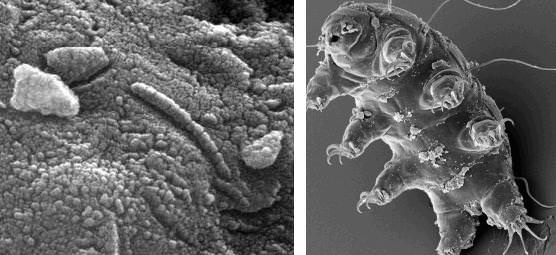
Put the term panspermia in a search engineand you get (left) ALH84001, a meteorite from Mars which has some funny looking structures which may just be mineral deposits; and (right) a tardigrade - a totally terrestrial organism that can endure high levels of radiation, desiccation and near vacuum conditions - although it much prefers to live in wet moss. Credit: NASA
The mechanism through which a dead alien genome usefully became the information template for further organic replication on Earth is not described in detail and the case for necropanspermia is not immediately compelling.
The theory still requires that the early Earth was ideally primed and ripe for seeding – with a gently warmed cocktail of organic compounds, shaken-but-not-stirred, beneath a protective atmosphere and a magnetosphere. Under these circumstances, the establishment of a primeval replicator through a fortuitous conjunction of organic compounds remains quite plausible. It is not clear that we need to appeal to the arrival of a dead interstellar virus to kick start the world as we know it.
Merapi Volcano on November 10, 2010, when the Moderate Resolution Imaging Spectroradiometer (MODIS) on NASA’s Terra satellite. Credit: NASA
[/caption]
For about three weeks, Indonesia’s Mount Merapi has been belching out lava, as well as ash and gas, clouding the atmosphere above. This satellite image, taken by NASA’s MODIS instrument on the Terra satellite, shows the volcano now settling down and is the most cloud-free satellite view of the volcano that we’ve been able to see. Thick ash is still rising and the volcano is still considered to be erupting at dangerous levels. Merapi is one of Indonesia’s most active volcanoes, and this eruption has been the most violent since the 1870’s.
The dark brown streak down the southern face of the volcano is ash and other volcanic material deposited by a pyroclastic flow or lahar. The volcano has been blamed for 156 deaths and about 200,000 people had to evacuate. The ash also caused flights to be delayed or canceled.
See below for a thermal image of the lava flow.
The Advanced Spaceborne Thermal Emission and Reflection Radiometer (ASTER) on NASA’s Terra satellite captured the thermal signature of hot ash and rock and a glowing lava dome on Mount Merapi on Nov. 1, 2010. Credit: NASA.
As a very active volcano, Merapi poses a constant threat to thousands of people in Indonesia. The Advanced Spaceborne Thermal Emission and Reflection Radiometer (ASTER) on NASA’s Terra satellite captured the thermal signature of hot ash and rock and a glowing lava dome. The thermal data is overlaid on a three-dimensional map of the volcano to show the approximate location of the flow. The three-dimensional data is from a global topographic model created using ASTER stereo observations.
For more information see NASA’s Earth Observatory website.
At best, the few extrasolar planets we have imaged directly are just points of light. But what can that light tell us about the planet? Maybe more than we thought. As you probably know the, Deep Impact spacecraft flew by comet Hartley 2 today, taking images from only 700 km away. But maneuvering to meet up with the comet is not the only job this spacecraft has been doing. The EPOXI mission also looked for ways to characterize extrasolar planets and the team made a discovery that should help identify distinctive information about extrasolar planets. How did they do it? By using the Deep Impact spacecraft to look at the planets in our very own solar system.
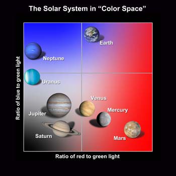
The spacecraft imaged the planetary bodies in our solar system — in particular the Earth, Mars and our Moon — (see here for movies of the Moon transiting Earth) and astronomer Lucy McFadden and UCLA graduate Carolyn Crow compared the reflected red, blue, and green light and grouped the planets according to the similarities they saw. The planets fall into very distinct regions on this plot, where the vertical direction indicates the relative amount of blue light, and the horizontal direction the relative amount of red light.
This suggests that when we do have the technology to gather light from individual exoplanets, astronomers could use color information to identify Earth-like worlds. “Eventually, as telescopes get bigger, there will be the light-gathering power to look at the colors of planets around other stars,” McFadden says. “Their colors will tell us which ones to study in more detail.”
On the plot, the planets cluster into groups based on similarities in the wavelengths of sunlight that their surfaces and atmospheres reflect. The gas giants Jupiter and Saturn huddle in one corner, Uranus and Neptune in a different one. The rocky inner planets Mars, Venus, and Mercury cluster off in their own corner of “color space.”
But Earth really stands out, and its uniqueness comes from two factors. One is the scattering of blue light by the atmosphere, called Rayleigh scattering, after the English scientist who discovered it. The second reason Earth stands out in color is because it does not absorb a lot of infrared light. That’s because our atmosphere is low in infrared-absorbing gases like methane and ammonia, compared to the gas giant planets Jupiter and Saturn.
“It is Earth’s atmosphere that dominates the colors of Earth,” Crow says. “It’s the scattering of light in the ultraviolet and the absence of absorption in the infrared.”
So, this filtering approach could provide a preliminary look at exoplanet surfaces and atmospheres, giving us an inkling of whether the planet is rocky or a gas planet, or what kind of atmosphere it has.
EPOXI is a combination of the names for the two extended mission components for the Deep Impact spacecraft: the first part of the acronym comes from EPOCh, (Extrasolar Planet Observations and Characterization) and the flyby of comet Hartley 2 is called the Deep Impact eXtended Investigation (DIXI).
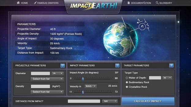
A 20-km asteroid has just been predicted to hit Earth and you want to know if a. You should run for it, b. You should call Bruce Willis, or c. You can rest easy because your part of the world won’t be affected. All you have to do is input the parameters of the asteroid on the recently updated “Impact Earth” website, and you’ll find out everything about what an impactor will do to Earth, including an estimate of the size of the crater, how far away you’ll need to be in order to avoid being affected by the impact (and if that is possible), tsunami wave height, and other details of the subsequent disaster. The fun part is, you can simulate the destruction of Earth multiple times, without hurting anyone.
The original Impact Earth website was created in 2002 for use by NASA and homeland security. The new version, built in a collaboration between Purdue University and Imperial College London, is more user-friendly for the general public, as well as providing more visual details of an impact. Besides being rather fun to play around with, the website is highly educational about what a various sized impacts would do Earth, depending on if it hit ground or water.
Fire scars in Australia are featured in this image photographed by an Expedition 5 crewmember on the International Space Station (ISS). Bright orange fire scars show up the underlying dune sand in the Simpson Desert, Credit: NASA
The International Space Station has been orbiting the Earth every day for over 10 years, and the astronauts all say their favorite pastime is looking at the Earth. During the past 10 years, the crews have taken some great pictures of our planet, and these images provide a unique look at our world. These are just a few of the spectacular views of Earth from the space station.
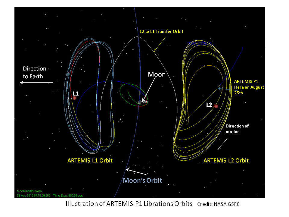
In another case of NASA reusing and recycling spacecraft, two of the five THEMIS spacecraft — which were studying the cause of geomagnetic substorms here on Earth — have a new mission. They made some very unique and complex maneuvers to reach two different LaGrange Points, and will turn their focus on the Moon. Particularly, they will try to determine how the solar wind electrifies, alters and erodes the lunar surface. This is timely since the discovery last year of water across the surface of the Moon which may be created by the solar wind interacting with the lunar surface.
The original THEMIS mission (Time History of Events and Macroscale Interactions during Substorms) featured five satellites that have now successfully completed their 2 year mission. Because they are continuing to work perfectly, NASA is re-directing the outermost two spacecraft to special orbits at and around the Moon. This new mission, which is called ARTEMIS: Acceleration, Reconnection, Turbulence and Electrodynamics of the Moon’s Interaction with the Sun.
[/caption]
It took more than a year and nearly all remaining fuel aboard the satellites to get them to the L1 and L2 Lagrangian points, where one is located on the far side of the Moon, and the other on the Earth-facing side. ARTEMIS-P1 is the first spacecraft to navigate to and perform stationkeeping operations around the Earth-Moon L1 and L2 Lagrangian points.
On August 25, 2010, ARTEMIS-P1 reached the L2 Lagrange point on the far side of the Moon. Following close behind, ARTEMIS-P2 entered the opposite L1 Lagrange point on Oct. 22nd.
As the Moon orbits the Earth, it passes in and out of the Earth’s magnetic field and the million-mile per hour stream of solar wind particles. While in these regions, the two ARTEMIS spacecraft will seek evidence for turbulence, particle acceleration, and magnetic reconnection, three fundamental phenomena that control the nature of the solar wind’s interaction with the Earth’s magnetosphere.
By using their instruments and unique two-point vantage points, the spacecraft will study the vacuum the Moon carves out in the solar wind, and the processes that eventually fill this lunar wake. Nearer the Moon, they will observe the effects of surface electric fields, ions sputtered off the lunar surface, and determine the internal structure of the Moon from transient variations in its magnetic field induced by external changes.
Apollo 9 astronaut Rusty Schweickart is among an international group of people championing the need for the human race to prepare for what will certainly happen one day: an asteroid threat to Earth. In an article on Universe Today published yesterday, Schweickart said the technology is available today to send a mission to an asteroid in an attempt to move it, or change its orbit so that an asteroid that threatens to hit Earth will pass by harmlessly. What would such a mission entail?
In a phone interview, Schweickart described two types of “deflection campaigns” for a threatening asteroid: a kinetic impact would roughly “push” the asteroid into a different orbit, and a gravity tractor would “tug slowly” on the asteroid to precisely “trim” the resultant change course by using nothing more than the gravitational attraction between the two bodies. Together these two methods comprise a deflection campaign.
Artist Impression of Deep Impact - Credit: NASA
“In a way, the kinetic impact was demonstrated by the Deep Impact mission back in 2005,” said Schweickart. “But that was a very big target and a small impactor that had relatively no effect on the comet. So, we haven’t really demonstrated the capability to have the guidance necessary to deflect a moderately sized asteroid.”
Most important, the gravity tractor spacecraft would arrive prior to the kinetic impactor, precisely determine the asteroid’s orbit and observe the kinetic impact to determine its effectiveness. Following the kinetic impact it would then determine whether or not any adjustment trim were required.
“You want to know what happens when you do a kinetic impact, so you want an ‘observer’ spacecraft up there as well,” Schweickart explained. “You don’t do a kinetic impact without an observation, because the impactor destroys itself in the process and without the observer you wouldn’t know what happened except by tracking the object over time, which is not the best way to find out whether you got the job done.”
So, 10-15 years ahead of an impact threat — or 50 years if you have that much time — an observer spacecraft is sent up. “This, in fact, would also be a gravity tractor,” Schweickart said. “It doesn’t have to be real big, but bigger gets the job done a little faster. The feature you are interested in the outset is not the gravity tractor but the transponder that flies in formation with the asteroid and you track the NEO, and back on Earth we can know exactly where it is.”
Schweickart said even from ground tracking, we couldn’t get as precise an orbit determination of an NEO as we could by sending a spacecraft to the object. Additionally, generally speaking, we may not know when we send an observer spacecraft what action will be required; whether an impact will be required or if we could rely on the gravity tractor. “You may launch at the latest possible time, but at that time the probability of impact may be 1 in 5 or 1 or 2,” Schweickart said. “So the first thing you are going to do with the observer spacecraft is make a precise orbit determination and now you’re going to know if it really will impact Earth and even perhaps where it will impact.”
Artist concept of an impactor heading towards an asteroid. Credit: ESA
After the precise orbit is known, the required action would be determined. “So now, if needed you launch a kinetic impactor and now you know what job has to be done,” Schweickart said. “As the impactor is getting ready to impact the asteroid, the observer spacecraft pulls back and images what is going on so you can confirm the impact was solid, –not a glancing blow — and then after impact is done, the observer spacecraft goes back in and makes another precision orbit determination so that you can confirm that you changed its velocity so that it no longer will hit the Earth.”
The second issue is, even if the NEO’s orbit has been changed so that it won’t hit Earth this time around, there’s the possibility that during its near miss it might go through what is called a “keyhole,” whereby Earth’s gravity would affect it just enough that it would make an impact during a subsequent encounter with Earth. This is a concern with the asteroid Apophis, which is projected to miss Earth in 2029, but depending on several factors, could pass through a keyhole causing it to return to hit Earth in 2036.
“So if it does go through that keyhole,” said Schweickart, “now you can use the gravity tractor capability of the spacecraft to make a small adjustment so that it goes between keyholes on that close approach. And now you have a complete verified deflection campaign.”
Schweickart said a Delta-sized rocket would be able to get a spacecraft to meet up with an asteroid. “A Delta rocket would work,” he said, “but if there is a more challenging orbit we might have to use something bigger, or we may have to use a gravity assist and do mission planning for type of thing which hasn’t been done yet. So we can get there, we can do it – but ultimately we will probably need a heavy lift vehicle.”
As for the spacecraft, we can use a design similar to vehicles that have already been sent into space.
“A gravity tractor could be like Deep Space 1 that launched in 1998,” Schweickart said. “ You can make any spacecraft into a gravity tractor fairly easily.”
Rusty Schweickart
But it hasn’t been demonstrated and Schweickart says we need to do so.
“We need to demonstrate it because we – NASA, the technical community, the international community — need to learn what you find out when you do something for the first time,” he said. “Playing a concerto in front of an audience is quite different from playing it alone in your house.”
A new NASA image of Earth, by Robert Simmon and Marit Jentoft-Nilsen, based on MODIS data.
[/caption]
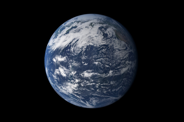
Despite recent news of potential habitable exoplanets and amazing images of Mars and the Saturn system returned from visiting spacecraft, the ol’ home planet is still about the most gorgeous-looking planetary body out there. We first saw it as a whole “blue marble” when the Apollo astronauts sent back pictures while circling the Moon, and it has been said that the original “Blue Marble” image taken by the Apollo 17 crew has been one of the most viewed and most influential images ever. But truth be told, that “Blue Marble” really wasn’t all that blue (see the original below). However, this new look at the home world shows how prevalent water really is. This composite image is based largely on observations from the Moderate Resolution Imaging Spectroradiometer (MODIS) on NASA’s Terra satellite.
It sure is pretty.
According to the NASA Earth Observatory website, Earth’s water content is about 1.39 billion cubic kilometers (331 million cubic miles), with the bulk of it, about 96.5%, being in the global oceans. As for the rest, approximately 1.7% is stored in the polar icecaps, glaciers, and permanent snow, and another 1.7% is stored in groundwater, lakes, rivers, streams, and soil. Only a thousandth of 1% of the water on Earth exists as water vapor in the atmosphere.
Here’s the original “Blue Marble,” the view of the Earth as seen by the Apollo 17 crew traveling toward the moon. This translunar coast photograph extends from the Mediterranean Sea area to the Antarctica south polar ice cap. This is the first time the Apollo trajectory made it possible to photograph the south polar ice cap. Almost the entire coastline of Africa is clearly visible. The Arabian Peninsula can be seen at the northeastern edge of Africa. The large island off the coast of Africa is Madagascar. The Asian mainland is on the horizon toward the northeast.
The original 'Blue Marble' taken by Apollo 17. Credit: NASA
Princeton University has developed software that can produce realistic “movies” of earthquakes based on complex computer simulations, and these visualizations will be available on the internet within hours of a disastrous upheaval. For example, this video of a 5.7 scale Earthquake off the coast of Peru occurred yesterday, September 22, 2010. “In our view, this could truly change seismic science,” said Princeton’s Jeroen Tromp, a professor of geosciences and applied and computational mathematics, who led the effort. “The better we understand what happens during earthquakes, the better prepared we can be. In addition, advances in understanding seismic waves can aid basic science efforts, helping us understand the underlying physics at work in the Earth’s interior. These visualizations, we believe, will add greatly to the research effort.”


 on NASA’s Terra satellite captured the thermal signature of hot ash and rock and a glowing lava dome on Mount Merapi on Nov. 1, 2010. Credit: NASA.")
. Bright orange fire scars show up the underlying dune sand in the Simpson Desert,")