Daring Russian Sample Return mission to Martian Moon Phobos aims for November Liftoff

Russian Phobos-Grunt spacecraft set to Launch in November 2011.The flight version of the Phobos-Grunt spacecraft minus its main solar panels is being lowered into a vacuum chamber at NITs RKP test facility in Peresvet, north of Moscow, for thermal, vacuum and electric tests around beginning of June 2011. Credit: NPO Lavochkin

[/caption]

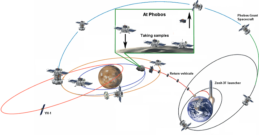
In just over 3 weeks’ time, Russia plans to launch a bold mission to Mars whose objective, if successful , is to land on the Martian Moon Phobos and return a cargo of precious soil samples back to Earth about three years later.

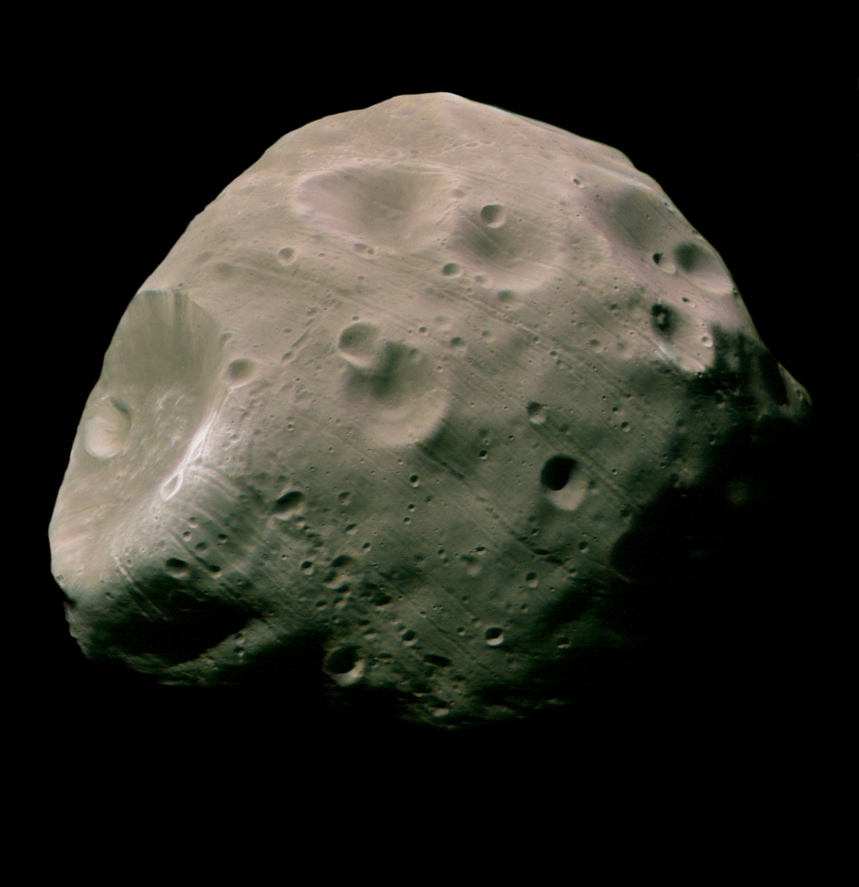
The purpose is to determine the origin and evolution of Phobos and how that relates to Mars and the evolution of the solar system.

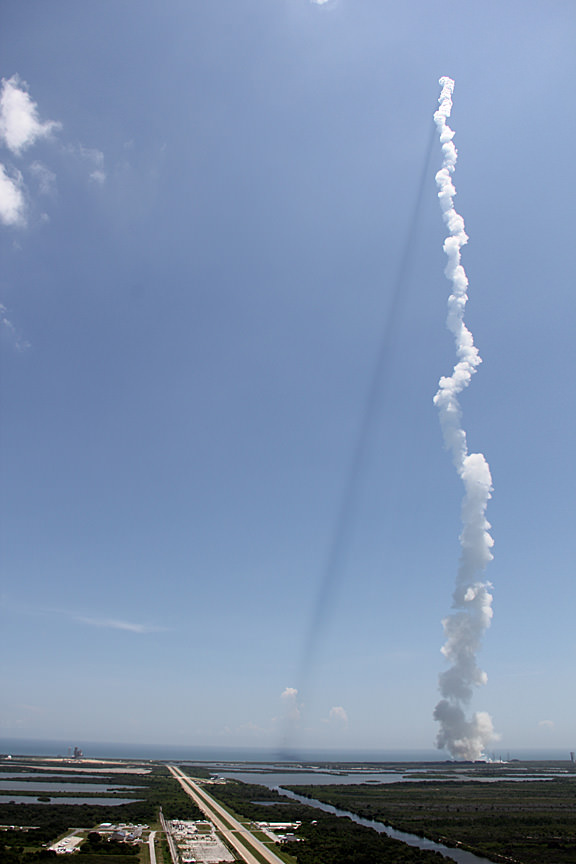
Liftoff of the Phobos-Grunt space probe will end a nearly two decade long hiatus in Russia’s exploration of the Red Planet following the failed Mars 96 mission and is currently scheduled to head to space just weeks prior to this year’s other Mars mission – namely NASA’s next Mars rover, the Curiosity Mars Science Laboratory (MSL).

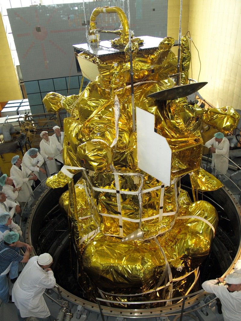
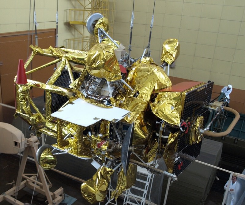
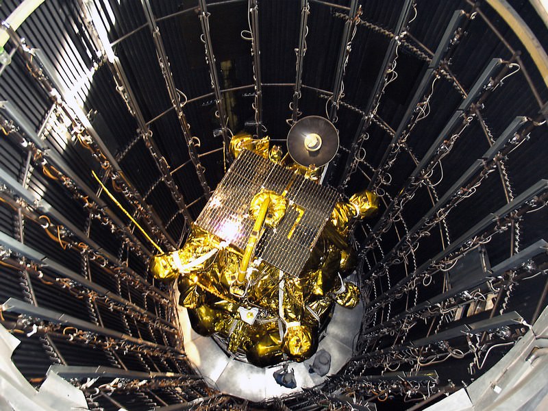
Blastoff of Phobos-Grunt may come as early as around Nov. 5 to Nov. 8 atop a Russian Zenit 3-F rocket from the Baikonur Cosmodrome in Kazakhstan. The launch window extends until about Nov. 25. Elements of the spacecraft are undergoing final prelaunch testing at Baikonur.

Flight version of the Phobos-Grunt spacecraft during assembly in preparation for critical testing in thermal and vacuum chamber at NITs RKP facility closely imitating harsh conditions of the real space flight. Credit: NPO Lovochkin

Baikonur is the same location from which Russian manned Soyuz rockets lift off for the International Space Station. Just like NASA’s Curiosity Mars rover, the mission was originally intended for a 2009 launch but was prudently delayed to fix a number of technical problems.

“November will see the launch of the Phobos-Grunt interplanetary automatic research station aimed at delivering samples of the Martian natural satellite’s soil to Earth’” said Vladimir Popovkin, head of the Russian Federal Space Agency, speaking recently at a session of the State Duma according to the Voice of Russia, a Russian government news agency.

Phobos-Grunt spacecraft

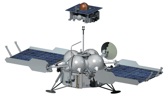
The spacecraft will reach the vicinity of Mars after an 11 month interplanetary cruise around October 2012. Following several months of orbital science investigations of Mars and its two moons and searching for a safe landing site, Phobos-Grunt will attempt history’s first ever touchdown on Phobos. It will conduct a comprehensive analysis of the surface of the tiny moon and collect up to 200 grams of soil and rocks with a robotic arm and drill.

Russian Phobos-Grunt spacecraft prepares for testing inside the vacuum chamber. Credit: NPO Lavochkin

After about a year of surface operations, the loaded return vehicle will blast off from Phobos and arrive back at Earth around August 2014. These would be the first macroscopic samples returned from another body in the solar system since Russia’s Luna 24 in 1976.

“The way back will take between nine and 11 months, after which the return capsule will enter Earth’s atmosphere at a speed of 12 kilometers per second. The capsule has neither parachute nor radio communication and will break its speed thanks to its conical shape,” said chief spacecraft constructor Maksim Martynov according to a report from the Russia Today news agency. He added that there are two soil collection manipulators on the lander because of uncertainties in the characteristics of Phobos soil.

Phobos-Grunt was built by NPO Lavochkin and consists of a cruise stage, orbiter/lander, ascent vehicle, and Earth return vehicle.

The spacecraft weighs nearly 12,000 kg and is equipped with a sophisticated 50 kg international science payload, in particular from France and CNES, the French Space Agency.

Also tucked aboard is the Yinghou-1 microsatellite supplied by China. The 110 kg Yinghou-1 is China’s first probe to launch to Mars and will study the Red Planet’s magnetic and gravity fields and surface environment from orbit for about 1 year.

“It will be the first time such research [at Mars] will be done by two spacecraft simultaneously. The research will help understand how the erosion of Mars’ atmosphere happens,” said Professor Lev Zelyony from the Space Research Institute of the Russian Academy of Science, according to Russia Today.

Phobos-Grunt mission scenario. Credit: CNES
Phobos seen by Mars Express. Credit: ESA

Read Ken’s continuing features about Phobos-Grunt, Curiosity and Opportunity starting here:
Assembling Curiosity’s Rocket to Mars
Encapsulating Curiosity for Martian Flight Test
Dramatic New NASA Animation Depicts Next Mars Rover in Action
Opportunity spotted Exploring vast Endeavour Crater from Mars Orbit
Twin Towers 9/11 Tribute by Opportunity Mars Rover
NASA Robot arrives at ‘New’ Landing Site holding Clues to Ancient Water Flow on Mars
Opportunity Arrives at Huge Martian Crater with Superb Science and Scenic Outlook
Opportunity Snaps Gorgeous Vistas nearing the Foothills of Giant Endeavour Crater
Opportunity Rover Heads for Spirit Point to Honor Dead Martian Sister; Science Team Tributes

Life In A Slice Of Ice

Image of the Harding Ice Field on Alaska’s Kenai Peninsula. Credit: US Fish and Wildlife Service

[/caption]

Thanks to a grant from the National Science Foundation, a University of Washington doctoral student named Adam Campbell has been conducting a research on photosynthetic algae. While this simple, light-loving form of life might not seem very important, it very well could have survived the global ice age by hiding in an area similar to the Red Sea.

“Under those frigid conditions, there are not a lot of places where you would expect liquid water and light to occur in the same area, and you need both of those things for photosynthetic algae to survive,” said Campbell.

How could this slice of ice endure against the massive force of a glacier? If there was a thin body of water about six and half times longer than it was wide, it would be possible for it to create enough physical resistance to stop a moving ice sheet. Chances are good that the ice would vaporize before it reached the end of the sea. This means at least enough open water for algae to survive.

“The initial results have shown pretty well that these kinds of channels could remain relatively free of thick glacial ice during a ‘snowball Earth’ event,” Campbell elucidates.

Through the use of an analytical model that simulates environmental conditions theorized to exist somewhere between 800 million and 550 million years ago, Campbell and his team of Edwin Waddington and Stephen Warren, UW professors of Earth and space sciences, were able to simulate ten million years of deep freeze. Their timeline began before the Cambrian explosion about 530 million years ago when Earth quickly changed tactics and became more heterogeneous. However, simple photosynthetic plankton have made their presence known in the records both before and after this studied time period… a presence which made scientists wonder how it could happen if the Earth had been totally covered in ice.

Campbell said it is assumed the algae survived these episodes, “unless they re-evolved each time, which creates a whole different problem for evolutionary biology.”

Why chose the Red Sea as an example? Quite simply put, because it’s perfect. It formed from a tectonic process called continental rifting, existed in the right time line and was correctly globally positioned. Campbell also noted that in a snowball Earth event, the exposed sea would have quickly evaporated if there weren’t a method of refill – such as created by a dam of glacial ice. Just a small amount… like enough to last 10 million years for the algae to take hold.

“Over 10 million years, you could evaporate the deepest lake in the world,” Campbell said. “If you’re in a desert, you’d have to have a supply of sea water.”

Original Story Source: University of Washington News.

Earth Vs. Stuff from the Sun

Compare the size of Eath to a prominence on the Sun on October 10, 2011. Credit: Ron Cottrell

[/caption]

The Sun is big. And comparatively, Earth is a tiny Lilliputian. We’ve all seen images comparing the size of Earth to the Sun, but here are two images from October 10, 2011 that really bring home the size-scale of features on the Sun when compared to the size of Earth. Amateur astronomer Ron Cottrell from Oro Valley, Arizona took these images of two different features on the the Sun yesterday, overlaying the size of the Earth for reference. Both are viewed in Hydrogen- Alpha light, and the first is a fiery-looking huge prominence from the northwest limb of the Sun. Yikes!

Below, see a comparison of Earth to a current sunspot:

The Earth compared to Sunspot 1312 on 10-10-11. Credit: Ron Cottrell.

This is sunspot 1312 which has a classic sunspot shape with a core a that’s larger than the Earth.

Ron used a 40mm Coronado telescope and a webcam to capture the images. He explains the colors of the Sun in Hydrogen-Alpha, and in particular why the prominence appears fiery red:

“The red color of the prominence is very close to the color collected in the image. The yellow disk is enhanced. I actually capture the disk image in black and white and add the color. I can choose any color. The final image is a composite of two separate images. Prominences are, in general, much fainter than the bright disk. Therefore, the prominence image is captured at a slower shutter speed, e.g. 1/25 sec, compared to the disk image captured at 1/100 sec. The two images are combined in PhotoShop.”

You can see more of Ron’s handiwork on his Flickr page.

And speaking of the Sun, activity on our closest star has been ramping up and last week a series of active regions were lined up one after the other across the upper half of the Sun. Interestingly, the Solar Dynamics Observatory was able to capture how these regions twisted and interacted with each other. The video shows activity from Sept. 28 – Oct. 2, 2011, as seen in extreme UV light. The magnetically intense active regions sported coils of arcing loops and numerous times these magnetic field lines above them can be seen connecting with the active region next door. Towards the end of the clip, a leading active region blasted out a coronal mass ejection, quickly succeeded by a blast from another active region. The disruption of the magnetic field from one likely triggered the second, a phenomenon that has been observed before by SDO.

What is Airglow?

Recent photo from the ISS showing the airglow layer

[/caption]

In many of the photos that we have featured recently from astronauts aboard the International Space Station, a glowing greenish-yellow band can be seen just above Earth’s limb. I’ve been asked before what this is, so I thought I’d explain it here. This is a phenomenon known as “airglow”.

A photochemical reaction that occurs high in the atmosphere, airglow is the result of various atoms, molecules and ions that get excited (chemistry-excited, that is… not “whee!”-excited) by ultraviolet radiation from the Sun and then release that energy as visible – as well as infrared – light when they return to their “normal” state. It’s not entirely unlike glow-in-the-dark toys or paint!

This light is most visible to the crew of the ISS when it is orbiting over the night side of the planet, and thus is seen in images like the one above. It appears like a thin band because viewing the atmosphere at a shallow angle – rather than directly down through it – increases the airglow layer’s relative visibility.

Most of visible airglow comes from oxygen atoms and molecules, which glow green… as commonly seen in the aurora. Other contributing elements include sodium and nitrogen. While present in the atmosphere at all layers, the region that glows visibly is typically constrained to a narrow band 85 – 95km (53-60 miles) high. The band itself is usually about 6 – 10km (4-6 miles) wide. The reason for this is that below those heights the atoms and molecules are more concentrated and collide more readily, releasing their energy sooner, and above it the density of the atoms is too low to do much colliding at all (to put it very simply.)

There are a lot of other factors involved with airglow as well, such as temperature and altitude, as well as different kinds of airglow depending on when in the day they occur. Nightglow is not exactly the same as dayglow, and then there’s even twilightglow… one could say there’s a lot glowing on in the upper atmosphere!

I’m here all week, folks.

You can read more about airglow in this informative article by the Institute of Astronomy and Astrophysics (Instituto de Astronomía y Física del Espacio) in Buenos Aires. Image credit: NASA.


Fires in the Sky, Fires on the Ground

The aurora australis seen from the ISS on September 17, 2011. Credit: NASA.


[/caption]

With all of the activity that’s been occurring on the Sun recently, the aurorae have been exceptionally bright and have created quite a show to viewers – both on Earth as well as above it!

The image above was taken over the southern Indian Ocean by astronauts aboard the International Space Station. The southern lights – a.k.a. aurora australis – glow bright green and red in the upper layers of the atmosphere, creating a dazzling aerial display. (Click here to watch a movie of this.)

Shortly after, fires can be seen on the ground as the ISS passes over Australia:

Wildfires in Australia seen from orbit. Credit: NASA.

From NASA’s Earth Observatory website:

Astronauts on the International Space Station (ISS) used a digital camera to capture several hundred photographs of the aurora australis, or “southern lights,” while passing over the Indian Ocean on September 17, 2011. You can see the flowing ribbons and rays below as the ISS passed from south of Madagascar to just north of Australia between 17:22 and 17:45 Universal Time. Solar panels and other sections of the ISS fill some of the upper right side of the photograph.

Auroras are a spectacular sign that our planet is electrically and magnetically connected to the Sun. These light shows are provoked by energy from the Sun and fueled by electrically charged particles trapped in Earth’s magnetic field, or magnetosphere. In this case, the space around Earth was stirred up by an explosion of hot, ionized gas from the Sun — a coronal mass ejection — that left the Sun on September 14, 2011.

In the second image above, and in the last frames of the movie, light from the ground replaces the light show in the sky. Wildfires and perhaps some intentionally set agricultural fires burn on the continent of Australia,with smoke plumes faintly visible in the night sky. A gold and green halo of atmospheric airglow hangs above the horizon in the distance.

______________

Airglow is created by particles in the upper atmosphere that have been charged by UV light from the Sun during the day releasing the energy at night as greenish-yellow visible light.

Fires on the ground, fires in the sky… the stars blazing all around, the Sun in its full glory and a never-ending view of our entire planet… what an incredible place the ISS must be to work in! Absolutely amazing!

And the skies of night were alive with light, with a throbbing, thrilling flame; Amber and rose and violet, opal and gold it came. It swept the sky like a giant scythe, it quivered back to a wedge; Argently bright, it cleft the night with a wavy golden edge.

— “The Ballad of the Northern Lights”, Robert Service

Read more on the NASA Earth Observatory.

Seen From Space: Sacred Rocks Of The Outback

Landsat 5 Image - Credits: USGS

[/caption]

Is this a close-up of what’s in that long forgotten plastic container you found on the back shelf of your refrigerator? No. It’s a Landsat 5 image of some of the most sacred areas in the Australian Outback. Let’s learn what they are…

The big picture is the Amadeus Basin – a sprawling area which covers much of the southern quarter of the Northern Territory and extends about 150 km into Western Australia. At the top of the image, you’ll see the salty Lake Amadeus. But looks here can be deceiving. Most of the time it isn’t a lake by traditional standards… it’s a huge salt deposit that awaits rainfall to become fluid.

The “bumps” at the center of the bottom of the image is Kata Tjuta, with its tallest peak being Mount Olga. Here the Pitjantjatjara Dreamtime legends begin, with nighttime ceremonies not revealed to outsiders. These legends are very beautiful and the formations echo their sentiments. Forty kilometres east of Kata Tjuta (and to the right) is one of the oldest formations on Earth – Ayers Rock – known to the Aboriginals as Uluru.

Ayers Rock by Joe Brimacombe

Formed some 500 million years ago when an ocean still covered the area, Uluru is thought of as the center of creation… not hard to imagine given that its singularity rises 1,142 feet above the desert and the base is an amazing 5 miles around. Ayers Rock consists of cave-covered walls with deep runnels caused by perpetual erosion. Aboriginal legend has it that the blood-red Uluru arose from the ocean in protest of war.

Perhaps a legend we’d all do well to listen to, eh?

Original Image: ESA – Observing Earth. Many thanks to the incomparable Joe Brimacombe for the use of his Ayers Rock image. Be sure to visit Joe’s Ayers Rock Area photo pages!

Report Earthquakes for Science!

We had a bit of a trembler here at Universe Today headquarters on Vancouver Island. According to the USGS, it was 6.4 magnitude, and the epicenter was located about 150 km from my house. It wasn’t the most severe earthquake I’ve felt, but there was no question… that was an earthquake.

Twitter user @OzoneVibe was good enough to pass along a link so I could report my experience for Science! The USGS provides a questionnaire for every earthquake so you can give your details about the shaking, any damage, etc. Here’s the one created for the Vancouver Island earthquake.

If you’re caught in an earthquake in the future, do a Google search for “did you feel it“. Then you can report your own experience and help geologists better understand earthquakes.

Now I’ve got to prepare for my kids coming home from school – they’ll hammer me with questions. I’m sure we’re going to be doing earth science late into the evening.

It Turns Out Some Borders *Are* Visible from Space

This picture shows the illuminated man-made border between India and Pakistan,the line snaking through the landscape, as seen from the International Space Station on August 21, 2011. Of the hundreds of clusters lights, the largest are the capital cities of Islamabad, Pakistan, and New Delhi, India. Credit: NASA/Ron Garan

[/caption]

There is an oft-repeated and perhaps beautiful saying that you can’t see political borders from space. Well, it turns out that saying isn’t true; not anymore. ISS astronaut Ron Garan took this image recently which clearly shows the border between India and Pakistan. Since 2003, India has illuminated the border with Pakistan by floodlights in attempt to prevent ammunition trafficking and the infiltration of terrorists.

“Since the beginning of human spaceflight fifty years ago, astronauts have reflected on how peaceful, beautiful, and fragile the Earth looks from space,” Garan wrote on his Fragile Oasis blog. “These reflections are not clichés that astronauts say because it feels good. It is truly moving to look at the Earth from space.”

But seeing this clearly visible political border was sobering for Garan and his crewmates.

“Realizing what this picture depicted had a big impact on me,” he said. “When viewed from space, Earth almost always looks beautiful and peaceful. However, this picture is an example of man-made changes to the landscape in response to a threat, clearly visible from space. This was a big surprise to me.”

Garan added, however, that the point here is not that we can look down at the Earth and see a man-made border between India and Pakistan. “The point is that we can look down at that same area and feel empathy for the struggles that all people face,” he said. “We can look down and realize that we are all riding through the Universe together on this spaceship we call Earth, that we are all interconnected, that we are all in this together, that we are all family.”

Garan said he believes our world is a place where possibilities are limited only by our imagination and our will to act. “It is within our power to eliminate the suffering and poverty that exist on our planet,” he said.

Read more on Fragile Oasis.

Exploring Geomagnetic Substorms

Schematic view of Cluster C3 and C1 satellite trajectories Copyright: ESA

[/caption]

Every now and again, a sudden pulse of energy in Earth’s magnetosphere just cuts loose. As a result, we have a bright polar auroral display. While we’re beginning to understand more about magnetism and the Sun/Earth connection, there’s still a few rogues left in the gallery. Just what is a geomagnetic substorm and what does it do?

Although we’ve known about them for years, the exact process behind a geomagnetic substorm has been a mystery… one that’s being solved with data from missions like ESA’s Cluster spacecraft. Earth is continually being bathed in incoming sheets of electrons and protons – the product of an active Sun. These highly energized particles are simply a part of solar winds flowing from coronal holes and even powerful blasts from events like coronal mass ejections. For the most part, we’re shielded by the magnetosphere – but sometimes a wee bit escapes and collects in the magnetotail – stored like a battery charge. At a point, it’s released… and when it does, it re-arranges our magnetic field lines. The energy then conducts itself along these lines like a filament in a light bulb. When the watts hit the fan? Wow… We have polar aurora!

It’s not a new concept, but there’s never been a clear understanding of where these geomagnetic storms originate. Do they come from a sudden disruption of electric current about 64 000 km from the planet? Or are the created by a process called magnetic reconnection which occurs much further down the magnetotail, at a distance of around 125 000 – 200 000 km? If you remember our recent study of Alfven waves, then you know current consensus points towards the reconnection theory. But there’s only one problem. Alfven waves are slow movers, traveling at a reconnection speed of about 250 seconds. What we’re seeing is an event that occurs about 60 seconds after reconnection… and the birth of a new movement. The kinetic Alfven wave (KAW).

“We ran a very simple system, and simulated how the reconnection event released energy in the plasma sheet of charged particles,” said Shay. “We were looking for a faster mechanism for propagating the signal from the explosion than the Alfven waves that were already widely recognized.”

Unlike its predecessor which motivates both ions and electrons, the KAW only excites the electron, moving them through the plasma at twice the speed. Through simulations, it’s been proved the kinetic Alfven wave could be spawned by reconnection, move away from the explosion and activate aurora. The data was returned by the Fluxgate Magnetometer (FGM) and the Electric Fields and Waves (EFW) instrument and found by Jonathan Eastwood, a Research Fellow at The Blackett Laboratory, Imperial College London.

“I found 18 events which occurred at the time the four spacecraft were flying through the tail region,” said Dr. Eastwood. “The fast signal predicted by Michael Shay showed up in the Cluster data, supporting the theory that kinetic Alfven waves generated by reconnection were rapidly energizing the auroras.”

“It’s rather like what happens in a thunderstorm,” he added. “The fast-moving lightning flash arrives first, followed some time later by the slower sound waves of the thunderclap.”

Fancy that… Coming from a substorm!

Original Story Source: ESA Science and Technology News. For Further Reading: Super-Alfvenic Propagation of Substorm Reconnection Signatures and Poynting Flux.

First Image Captured by NASAs Jupiter bound Juno; Earth – Moon Portrait

Earth & Moon Portrait - First Photo transmitted from Jupiter Bound Juno. This image of Earth (on the left) and the moon (on the right) was taken by NASA's Juno spacecraft on Aug. 26, 2011, when the spacecraft was about 6 million miles (9.66 million kilometers) away. It was taken by the spacecraft's onboard camera, JunoCam. Credit: NASA/JPL-Caltech

[/caption]

NASA’s solar powered Jupiter bound Juno orbiter has captured her first image – a beautiful portrait of the Earth & Moon – since the probe blasted off from the home planet.

Juno lifted off 25 days ago at 12: 25 p.m. on August 5 from Space Launch Complex 41 at Cape Canaveral Air Force Station in Florida. The spacecraft snapped the portrait with the onboard JunoCam camera on August 26 after journeying some 6 million miles (9.66 million km) from Earth and while traveling at a velocity of 77,600 miles per hour (124,900 kilometers per hour) relative to the sun.

“The image of the Earth Moon system is a rather unique perspective that we can get only by stepping outside of our home planet,” said Scott Bolton, Juno principal investigator, in an exclusive interview with Universe Today. Bolton is from the Southwest Research Institute in San Antonio.

“On our way to Jupiter, we’ve looked back at home and managed to take this amazing image.”

“Earth looking much like any other planet or star from a distance is glorious as this somewhat average looking “star” is home to all of humanity. Our companion, the moon, so beautiful and important to us, stands out even less.”

“We appear almost average and inconspicuous, yet all of our history originates here. It makes one wonder just how many other planets or solar systems might contain life like ours,” Bolton told me.

Juno casts a shadow back toward Earth and Space Shuttle Launch Pad 39A and the shuttle crawler way (at left) seconds after liftoff from adjacent Launch Pad 41 at Cape Canaveral, Florida. View from the VAB Roof. Credit: Ken Kremer

The Juno team commanded the probe to take the image as part of the checkout phase of the vehicles instruments and subsystems.

“The JunoCam instrument turn on and check out were planned activities. The instrument is working great and in fact, all the instruments that we’ve turned on thus far have been working great,” Bolton added.

So far the spacecraft is in excellent health and the team has completed the checkout of the Waves instrument and its two Flux Gate Magnetometer sensors and deployment of its V-shaped electric dipole antenna.

“We have a couple more instruments still to do,” Bolton noted.

The team reports that Juno also performed its first precession, or reorientation maneuver, using its thrusters and that the first trajectory control maneuver (TCM-1) was cancelled as unnecessary because of the extremely accurate targeting provided by the Atlas V rocket.

The portrait shot is actually not Juno’s last photo of her home.

The 8000 pound (3,600 kilogram) probe will fly by Earth once more on October 9, 2013 for a gravity assisted speed boost of 16,330 MPH (7.3 km/sec) to accelerate Juno past the asteroid belt on its long journey to the Jovian system.

Juno soars skyward to Jupiter on Aug. 5 from launch pad 41 at Cape Canaveral Air Force Station at 12:25 p.m. EDT. View from the VAB roof. Credit: Ken Kremer

JunoCam will collect new photos and the other science instruments will make measurements as Juno cartwheels past Earth during the slingshot to Jupiter.

Juno is on a 5 year and 1.7 Billion mile (2.8 Billion km) trek to the largest planet in our solar system. When she arrives at Jupiter on July 4, 2016, Juno will become the first polar orbiting spacecraft at the gas giant.

During a one year science mission – entailing 33 orbits lasting 11 days each – the probe will plunge to within about 3000 miles (5000 km) of the turbulent cloud tops and collect unprecedented new data that will unveil the hidden inner secrets of Jupiter’s genesis and evolution.

The goal is to find out more about the planets origins, interior structure and atmosphere, observe the aurora, map the intense magnetic field and investigate the existence of a solid planetary core.

“This is a remarkable sight people get to see all too rarely,” said Bolton in a NASA statement about the Earth-Moon photo. “This view of our planet shows how Earth looks from the outside, illustrating a special perspective of our role and place in the universe. We see a humbling yet beautiful view of ourselves.”

NASA’s Jet Propulsion Laboratory manages the Juno mission. The spacecraft was designed and built by Lockheed Martin Space Systems, Denver.

Juno and Booster Streak Across the Stars
NASA's Juno spacecraft and its spent Centaur upper rocket stage are captured in this telescope view as they move across the field of stars. The five-minute, timed exposure was acquired on Aug. 5 11:18pm Eastern time (Aug. 6 at 3:18 UTC) when Juno was at a distance of about 195,000 miles (314,000 kilometers) from Earth. The images were taken remotely by amateur astronomer Scott Ferguson using Global Rent-a-Scope's GRAS-016 Takahashi Widefield Refractor, which is located in Nerpio, Spain. Credit: Scott Ferguson
Juno Spacecraft Cruise Trajectory to Jupiter
This graphic shows Juno's trajectory, or flight path, from Earth to Jupiter. The spacecraft travels around the Sun, to a point beyond the orbit of Mars where it fires its main engine a couple of times. These deep space maneuvers set up the Earth flyby maneuver that occurs approximately two years after launch. The Earth flyby gives Juno the boost in velocity it needs to coast all the way to Jupiter. Juno arrives at Jupiter in July 2016. Credit: NASA/JPL-Caltech
View of Juno’s position on Aug. 24, 2011 nearly 6 million miles distant from Earth visualized by NASA’s Eyes on the Solar System website.

Read my continuing features about Juno
Juno Blasts off on Science Trek to Discover Jupiter’s Genesis
Juno Jupiter Orbiter poised at Launch Pad for Aug. 5 Blastoff
JUNO Orbiter Mated to Mightiest Atlas rocket for Aug. 5 Blastoff to Jupiter
Solar Powered Jupiter bound JUNO lands at Kennedy Space Center