Flawless Maiden Launch for Europe’s New Vega Rocket

On 13 February 2012, the first Vega lifted off on its maiden flight from Europe's South American Spaceport in French Guiana and deployed 9 science satellites. Credits: ESA - S. Corvaja

[/caption]

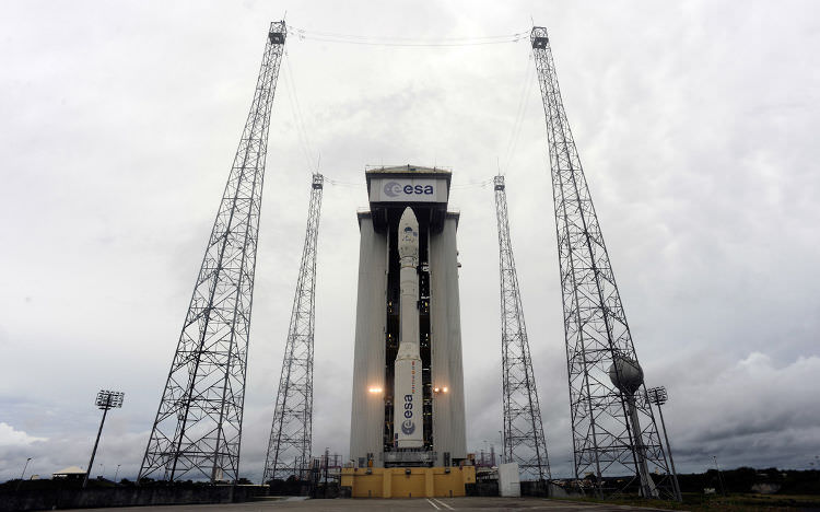
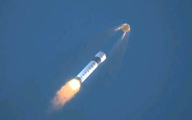
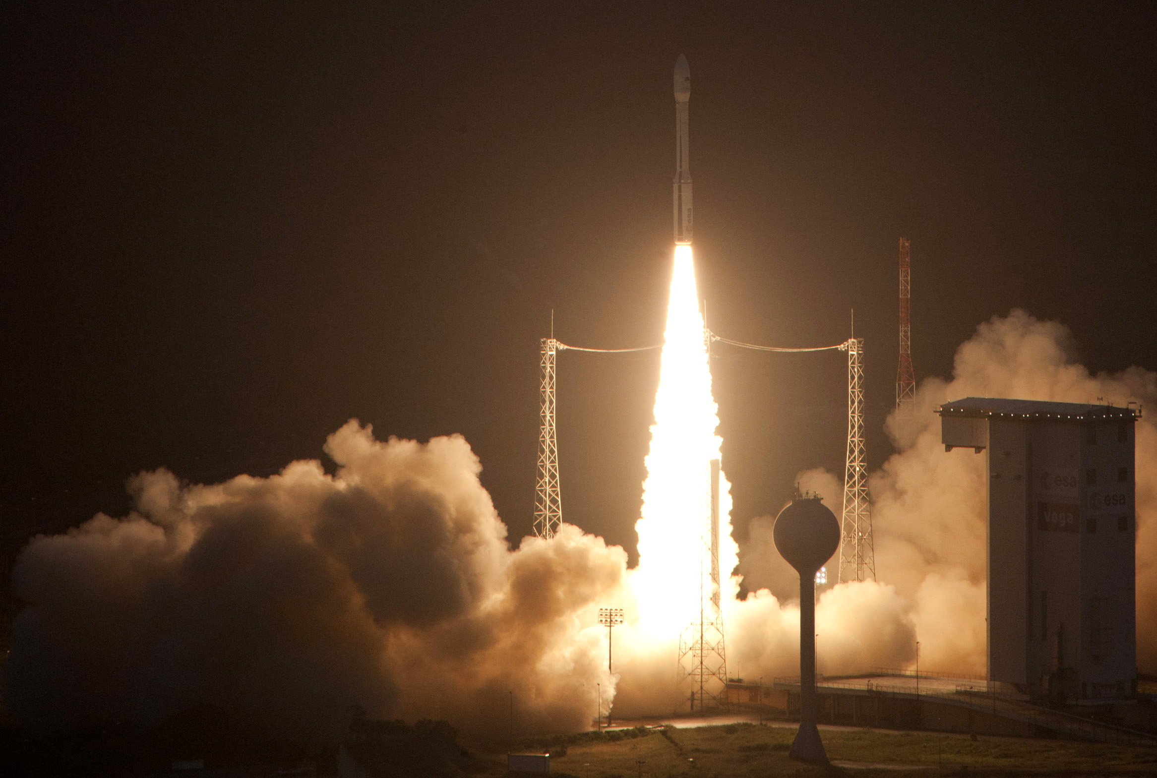
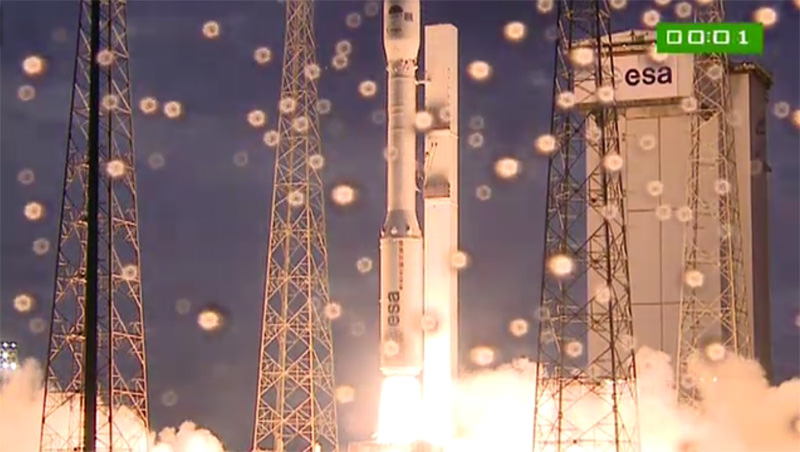
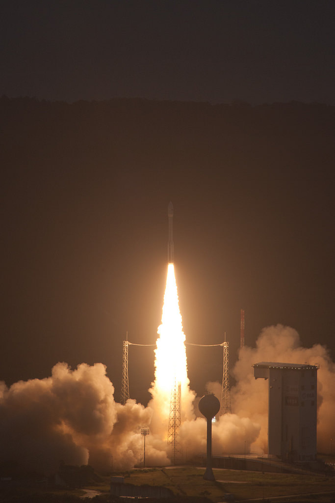
Europe scored a major space success with today’s (Feb. 13) flawless maiden launch of the brand new Vega rocket from Europe’s Spaceport in Kourou, French Guiana.

The four stage Vega lifted off on the VV01 flight at 5:00 a.m. EST (10:00 GMT, 11:00 CET, 07:00 local time) from a new launch pad in South America, conducted a perfectly executed qualification flight and deployed 9 science satellites into Earth orbit.

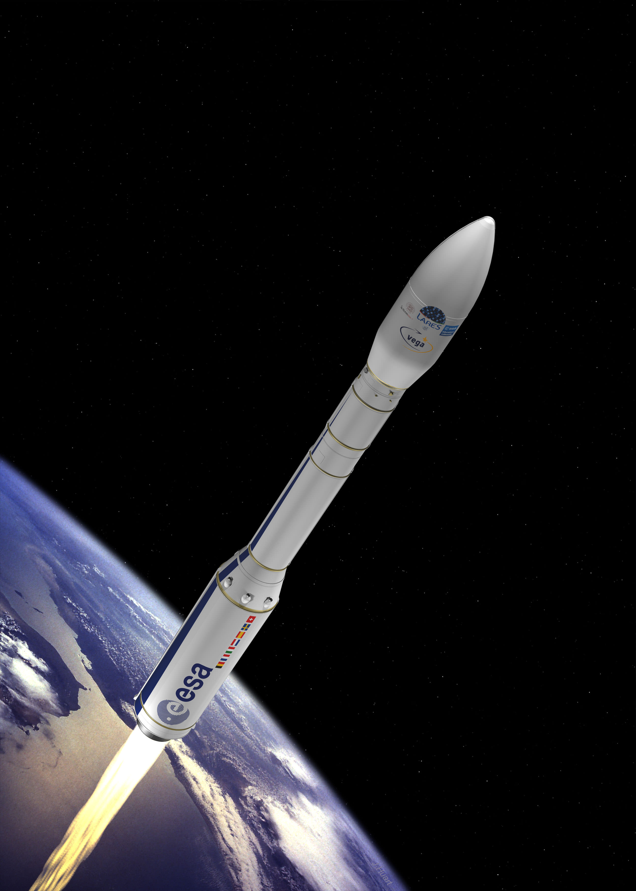
Vega is a small rocket launcher designed to loft science and Earth observation satellites.

Liftoff of Maiden Vega Rocket on Feb. 13, 2012 on VV01 flight from ESA Spaceport at French Guiana. Credit: ESA

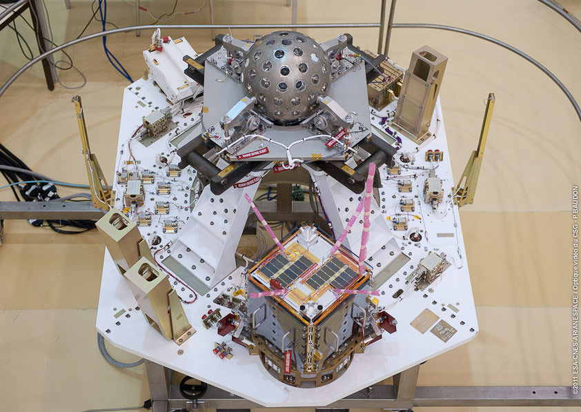
The payload consists of two Italian satellites – ASI’s LARES laser relativity satellite and the University of Bologna’s ALMASat-1 – as well as seven picosatellites provided by European universities: e-St@r (Italy), Goliat (Romania), MaSat-1 (Hungary), PW-Sat (Poland), Robusta (France), UniCubeSat GG (Italy) and Xatcobeo (Spain).

On 13 February 2012, the first Vega lifted off on its maiden flight from Europe's Spaceport in French Guiana. Credits: ESA - S. Corvaja

Three of these cubesats were the first ever satellites to be built by Poland, Hungary and Romania. They were constructed by University students who were given a once in a lifetime opportunity by ESA to get practical experience and launch their satellites for free since this was Vega’s first flight.

The 30 meter tall Vega has been been under development for 9 years by the European Space Agency (ESA) and its partners, the Italian Space Agency (ASI), French Space Agency (CNES). Seven Member States contributed to the program including Belgium, France, Italy, the Netherlands, Spain, Sweden and Switzerland as well as industry.

Vega's first launch, dubbed VV01, occurred on Feb 13, 2012 from Europe's Spaceport in Kourou, French Guiana. It carried nine satellites into orbit: LARES, ALMASat-1 and seven Cubesats. Credits: ESA - J. Huart
ESA can now boast a family of three booster rockets that can service the full range of satellites from small to medium to heavy weight at their rapidly expanding South American Spaceport at the Guiana Space Center.

Vega joins Europe’s stable of launchers including the venerable Ariane V heavy lifter rocket family and the newly inaugurated medium class Russian built Soyuz booster and provides ESA with an enormous commercial leap in the satellite launching arena.

“In a little more than three months, Europe has increased the number of launchers it operates from one to three, widening significantly the range of launch services offered by the European operator Arianespace. There is not anymore one single European satellite which cannot be launched by a European launcher service,” said Jean-Jacques Dordain, Director General of ESA.

“It is a great day for ESA, its Member States, in particularly Italy where Vega was born, for European industry and for Arianespace.”

Dordain noted that an additional 200 workers have been hired in Guiana to meet the needs of Europe’s burgeoning space programs. Whereas budget cutbacks are forcing NASA and its contractors to lay off tens of thousands of people as a result of fallout from the global economic recession.

LARES, ALMASat-1 and CubeSats satellites integration for 1st Vega launch.
Credits: ESA, CNES, Arianespace, Optique Video du CSG, P. Baudon

ESA has already signed commercial contracts for future Vega launches and 5 more Vega rockets are already in production.

Vega’s light launch capacity accommodates a wide range of satellites – from 300 kg to 2500 kg – into a wide variety of orbits, from equatorial to Sun-synchronous.

“Today is a moment of pride for Europe as well as those around 1000 individuals who have been involved in developing the world’s most modern and competitive launcher system for small satellites,” said Antonio Fabrizi, ESA’s Director of Launchers.

ESA’s new Vega rocket fully assembled on its launch pad at Europe’s Spaceport in Kourou, French Guiana.

Far Above the World

Astronaut Bruce McCandless untethered above the Earth on Feb. 12, 1984. (NASA)

[/caption]

28 years ago today, NASA astronaut Bruce McCandless left the relative safety of Challenger’s payload bay and went untethered into orbit around Earth, venturing farther than anyone ever before.

The historic photo above was taken when McCandless was 320 feet from the orbiter — about the length of an American football field, or just shy of the width of the International Space Station.

The free-flying endeavor was possible because of McCandless’ nitrogen-powered jet-propelled backpack, called a Manned Maneuvering Unit (MMU). It attached to the space suit’s life-support system and was operated by hand controls, allowing untethered access to otherwise inaccessible areas of the orbiter and was also used in the deployment, service and retrieval of satellites.

Astronaut Dale Gardner using the MMU during STS-51A in Nov. 1984 to travel to the Westar VI satellite. (NASA)

The MMU used a non-contaminating nitrogen propellant that could be recharged in the orbiter. It weighed 140 kg (308 lbs) and has a built-in 35mm camera.

After the Challenger disaster, the MMU was deemed too risky and was discontinued. But for a brief period of time in the early ’80s, humans had the means for really “soaring to new heights”.

Image credits: NASA

New Computer Simulations Show Earth’s Spaghetti-Like Magnetosphere

Supercomputer simulation showing the tangled magnetosphere surrounding Earth. Credit: OLCF

[/caption]

A new computer simulation is showing Earth’s magnetosphere in amazing detail – and it looks a lot like a huge pile of tangled spaghetti (with the Earth as a meatball). Or perhaps a cosmic version of modern art.

The magnetosphere is formed by the Sun’s magnetic field interacting with Earth’s own magnetic field. When charged particles from a solar storm, also known as a coronal mass ejection (CME), impact our magnetic field, the results can be spectacular, from powerful electrical currents in the atmosphere to beautiful aurorae at high altitudes. Space physicists are using the new simulations to better understand the nature of our magnetosphere and what happens when it becomes extremely tangled.

Using a Cray XT5 Jaguar supercomputer, the physicists can better predict the effects of space weather, such as solar storms, before they actually hit our planet. According to Homa Karimabadi, a space physicist at the University of California-San Diego (UCSD), “When a storm goes off on the sun, we can’t really predict the extent of damage that it will cause here on Earth. It is critical that we develop this predictive capability.” He adds: “With petascale computing we can now perform 3D global particle simulations of the magnetosphere that treat the ions as particles, but the electrons are kept as a fluid. It is now possible to address these problems at a resolution that was well out of reach until recently.”

It helps that the radiation from solar storms can take 1-5 days to reach Earth, providing some lead time to assess the impact and any potential damage.

The previous studies were done using the Cray XT5 system known as Kraken; with the new Cray XT5 Jaguar supercomputer, they can perform simulations three times as large. The earlier simulations contained a “resolution” of about 1 billion individual particles, while the new ones contain about 3.2 trillion, a major improvement.

So next time you are eating that big plate of spaghetti, look up – the universe has its own recipes as well.

The original press release from Oak Ridge National Laboratory is here.

Can you See the Pyramids from Space?

Click for a larger version of this image to see if you can see the Pyramids at Giza from the International Space Station. Via astronaut Nicole Stott's Twitpic feed.

[/caption]

Astronaut Nicole Stott posted this image on her Twitter account. If you can spot the Great Pyramids at Giza in this small image, you’ve pretty good eyesight! Click the image for a larger version if can’t find them.

Astronaut Soichi Noguchi posted an image of different set of pyramids at Dahshur, Egypt, from his stint on the ISS in 2010. He zoomed in a little more, making them easier to see, below:

The Red Pyramid and the Bent Pyramid in Dahshur, Egypt. Credit: Soichi Noguchi/NASA/JAXA

But there’s still the question, can you see the Great Wall of China from space?

ISS Night Flight in “Real Time”

We’ve featured wonderful time-lapse videos taken from the Space Station many times and each one is amazing to watch, but here’s something a little different: by taking photos at the rate of one per second and assembling them into a time-lapse, we can get a sense of what it’s like to orbit the planet at 240 miles up, 17,500 mph… in real time. Absolutely amazing!

Continue reading “ISS Night Flight in “Real Time””

Super Bowl Cities Seen From Space

Satellite image of RI and portions of southeastern Massachusetts. Credit: NASA/GSFC/Landsat 7

[/caption]

If you live in or are from the US, you probably know that today is Super Bowl Sunday. Whatever you happen to be doing, be it tailgating in Indianapolis, getting together with friends and family (and plenty of hot wings and nachos) in your living room or just waiting for all the fuss to be over, remember that, high above, NASA Earth-observing satellites are working hard doing what they do best: observing the Earth. Chances are they’ve imaged your home town many times.

Whichever team you’re rooting for, here’s a little bit of space science fun: the folks over at Goddard Space Flight Center in Greenbelt, MD, have shared some Landsat images of the home cities of this year’s big game.

The image above shows the central and northern RI and southeastern Massachusetts area, with Providence and Pawtucket seen as the densely-built central region and Foxborough, MA, where the Patriots’ home stadium is located, is just to the north of the image. This image was acquired by Landsat 7 in July 2002.

(Being of my home state, I admit I’m partial to that particular shot. I was down there somewhere!)

The NYC area seen from satellite. Credit: NASA/GSFC/Landsat 7

If you’re a die-hard Giants fan, you may recognize this area… you may even be in it! It’s a Landsat 7 image of the New York metro area acquired on August 8, 2002. Manhattan is in the center, most easily recognizable from space by the green rectangle of Central Park. New Jersey is on the left side, and Brooklyn on the center-right with Long Island stretching away to the east.

Indianapolis from Landsat 7 satellite. Credit: NASA/GSFC/Landsat 7

If you’re lucky enough to have tickets to the big game, you may be here: it’s a Landsat image of Indianapolis, IN acquired on July 11, 2001. The Colts may not have made it this year but right now the city is definitely “ready for some football!”

Of course, team and town loyalty aside, this gorgeous image from Expedition 30 crew members aboard the ISS shows everyone all in one place on the night of January 29, 2012 – with a nice touch of northern lights thrown in for good measure:

US East Coast on Jan. 29, 2012. (NASA)

Bright lights, big cities… but a small world, when you think about it. And remember, whichever team comes out on top today, tomorrow we’re all winners. (Until next season, of course!)

You can see these and more images from Goddard Space Flight Center on their Flickr album, and find out more about Landsat and how it benefits people around the world.

And you can follow Super Bowl XLVI news – and watch online – on the official NFL site here.

Cities at Night Panorama of Millions of US East Coast Earthlings

Nighttime Panorama of US East Coast from the ISS. Astronauts aboard the International Space Station (ISS) captured this stunning nighttime panorama of the major cities along the East Coast of the United States on Jan. 29. Credit: NASA

[/caption]

Do you live here?

Tens of millions of Earthlings live and work in the bustling and seemingly intertwined American mega-metropolis of the Philadelphia-New York City-Boston corridor (bottom-center splotch) captured in this stunning “Cities at Night” panorama of the East Coast of the United States along the Atlantic seaboard (image above).

Look northward and you’ll see the home to millions more Earthlings inhabiting the brilliantly lit Canadian cities of Toronto (launch site for “Lego Man in Space“) and Montreal to the west of Lake Ontario (dark oval at left-center).

The gorgeous panorama showing a portion of the Earth at Night and the atmospheric limb and light activity from the Aurora Borealis was snapped by the Expedition 30 crew living and working aboard the million pound International Space Station (ISS) on Jan. 29.

Lately, the 6 man international crew of Expedition 30 from Russia, Holland and the US have been on a roll taking one after another magnificent Nighttime pictures of our Home Planet, Auroras’ and celestial wonders like Comet Lovejoy.

Be sure to take a comparative look at the recent panorama of Western Europe at Night snapped by the ISS crew a week before on Jan 22 – here.

To test your geography smarts, here’s a map of the US East Coast highlighting much of what’s visible in the ISS panorama.

This Earthling has lived in cities on the US East Coast and Western Europe – images above and below

Western Europe at Night
European ‘Cities at Night’ from the ISS with station solar arrays and robotic hand in foreground. Credit: NASA

Two years ago in Feb. 2010, the US East Coast was struck by “Snowmageddon”, and this is how we looked from space

Meanwhile, two of the Expedition 30 crew members, Russian Flight Engineers Oleg Kononenko and Anton Shkaplerov, are preparing for a spacewalk on Friday, Feb. 16. They will be installing equipment outside the ISS on the Russian Pirs, Poisk and Zvezda modules.

How Plants May Have Helped Create Earth’s Unique Landscapes

Credit: Wikimedia Commons

[/caption]

According to conventional thinking, plant life first took hold on Earth after oceans and rivers formed; the soil produced by liquid water breaking down bare rock provided an ideal medium for plants to grow in. It certainly sounds logical, but a new study is challenging that view – the theory is that vascular plants, those containing a transport system for water and nutrients, actually created a cycle of glaciation and melting, conditions which led to the formation of rivers and mud which allowed forests and farmland to later develop. In short, they helped actually create the landscapes we see today.

The evidence was just published in two articles in a special edition of Nature Geoscience.

In the first article, analysis of the data proposes that vascular plants began to absorb the carbon dioxide in the atmosphere about 450 million years ago. This led to a cooling of temperatures on a global scale, resulting in widespread glaciation. As the glaciers later started to melt, they ground up the Earth’s surface, forming the kind of soils we see today.

The second article goes further, stating that today’s rivers were also created by vascular plants – the vegetation broke the rocks down into mud and minerals and then also held the mud in place. This caused river banks to start forming, acting as channels for water, which up until then had tended to flow over the surface much more randomly. As the water was channeled into more specific routes, rivers formed. This led to periodic flooding; sediments were deposited over large areas which created rich soil. As trees were able to take root in this new soil, debris from the trees fell into the rivers, creating logjams. This had the effect of creating new rivers and causing more flooding. These larger fertile areas were then able to support the growth of larger lush forests and farmland.

According to Martin Gibling, a professor of Earth science at Dalhousie University, “Sedimentary rocks, before plants, contained almost no mud. But after plants developed, the mud content increased dramatically. Muddy landscapes expanded greatly. A new kind of eco-space was created that wasn’t there before.”

The new theory also leads to the possibility that any exoplanets that happen to have vegetation would look different from Earth; varying circumstances would create a surface unique to each world. Any truly Earth-like exoplanets might be very similar in general, but the way that their surfaces have been modified might be rather different.

It’s an interesting scenario, but it also raises other questions. What about the ancient river channels on Mars? Some appear to have been formed by brief catastrophic floods, but others seem more similar to long-lived rivers here on Earth, especially if there actually was a northern hemisphere ocean as well. How did they form? Does this mean that rivers could form in a variety of ways, with or without plant life being involved? Could Mars have once had something equivalent to vascular plant life as well? Or could the new theory just be wrong? Then there’s Titan, which has numerous rivers still flowing today. Albeit they are liquid methane/ethane instead of water, but what exactly led to their formation?

From the editorial in Nature Geoscience:

Without the workings of life, the Earth would not be the planet it is today. Even if there are a number of planets that could support tectonics, running water and the chemical cycles that are essential for life as we know it, it seems unlikely that any of them would look like Earth. Even if evolution follows a predictable path, filling all available niches in a reproducible and consistent way, the niches on any Earth analogue could be different if the composition of its surface and atmosphere are not identical to those of Earth. And if evolution is random, the differences would be expected to be even larger. Either way, a glimpse of the surface of an exoplanet — if we ever get one — may give us a whole new perspective on biogeochemical cycling and geomorphology.

Just as the many exoplanets now being found are of a previously unknown and amazingly wide variety, and all uniquely alien, even the ones that (may) support life are likely to be just as diverse from each other as they are from Earth itself. Earth’s “twin” may be out there, but in terms of outward appearance, it may be somewhat more of a fraternal twin than an exact replica.

SpaceX Test Fires SuperDraco Abort Engines Critical To Astronaut Launch Safety

SpaceX test-fires its SuperDraco engine that powers the manned Dragon spacecraft launch escape system critical for Astronaut safety during launch to orbit. Credit: SpaceX

[/caption]

Space Exploration Technologies (SpaceX) has test fired a prototype of its new SuperDraco engine that will be critical to saving the lives of astronauts flying aboard a manned Dragon spacecraft soaring to orbit in the event of an in-flight emergency.

The successful full-duration, full-thrust firing of the new SuperDraco engine prototype was completed at the company’s Rocket Development Facility in McGregor, Texas. The SuperDraco is a key component of the launch abort system of the Dragon spacecraft that must fire in a split second to insure crew safety during launch and the entire ascent to orbit.

The Dragon spacecraft is SpaceX’s entry into NASA’s commercial crew development program – known as CCDEV2 – that seeks to develop a commercial ‘space taxi’ to launch human crews to low Earth orbit and the International Space Station (ISS).

The engine fired for 5 seconds during the test, which is the same length of time the engines need to burn during an actual emergency abort to safely thrust the astronauts away.

Watch the SpaceX SuperDraco Engine Test Video:

Nine months ago NASA awarded $75 million to SpaceX to design and test the Dragon’s launch abort system . The SuperDraco firing was the ninth of ten milestones that are to be completed by SpaceX by around May 2012 and that were stipulated and funded by a Space Act Agreement (SAA) with NASA’s Commercial Crew Program (CCP).

“SpaceX and all our industry partners are being extremely innovative in their approaches to developing commercial transportation capabilities,” said Commercial Crew Program Manager Ed Mango in a NASA statement. “We are happy that our investment in SpaceX was met with success in the firing of its new engine.”

Dragon will launch atop the Falcon 9 rocket, also developed by SpaceX.

SpaceX test-fires its SuperDraco engine that will eventually power the manned Dragon spacecrafts launch escape system critical for Astronaut safety during launch to orbit. Credit: SpaceX

“Eight SuperDracos will be built into the sidewalls of the Dragon spacecraft, producing up to 120,000 pounds of axial thrust to quickly carry astronauts to safety should an emergency occur during launch,” said Elon Musk, SpaceX chief executive officer and chief technology officer in a statement. “Those engines will have the ability to deep throttle, providing astronauts with precise control and enormous power.”

“Crews will have the unprecedented ability to escape from danger at any point during the launch because the launch abort engines are integrated into the side walls of the vehicle,” Musk said. “With eight SuperDracos, if any one engine fails the abort still can be carried out successfully.”

SuperDraco engines will power the launch escape system of SpaceX’s Dragon. Eight SuperDraco engines built into the side walls of the Dragon spacecraft will produce up to 120,000 pounds of axial thrust to carry astronauts to safety should an emergency occur during launch. Credit: SpaceX

SpaceX is one of four commercial firms working to develop a new human rated spacecraft with NASA funding. The other firms vying for a commercial crew contract are Boeing, Sierra Nevada and Blue Origin.

“SuperDraco engines represent the best of cutting edge technology,” says Musk. “These engines will power a revolutionarylaunch escape system that will make Dragon the safest spacecraft in history and enable it to land propulsively on Earth or another planet with pinpoint accuracy.”

The privately developed space taxi’s will eventually revive the capability to ferry American astronauts to and from the ISS that was totally lost when NASA’s Space Shuttle orbiters were forcibly retired before a replacement crew vehicle was ready to launch.

Because the US Congress slashed NASA’s commercial crew development funding by more than 50% -over $400 million – the first launch of a commercial space taxi is likely to be delayed several more years to about 2017. Until that time, all American astronauts must hitch a ride to the ISS aboard Russian Soyuz capsules.

This week the Russian manned space program suffered the latest in a string of failures when when technicians performing a crucial test mistakenly over pressurized and damaged the descent module of the next manned Soyuz vehicle set to fly to the ISS in late March, thereby forcing about a 45 day delay to the launch of the next manned Soyuz from Kazakhstan.

NASA’s Blue Marble…Side B.

Earth's eastern hemisphere made from Suomi NPP satellite images. (NASA/NOAA)

[/caption]

In response to last week’s incredibly popular “Blue Marble” image, NASA and NOAA have released a companion version, this one showing part of our planet’s eastern hemisphere.

The image is a composite, made from six separate high-resolution scans taken on January 23 by NASA’s recently-renamed Suomi NPP satellite.

From the description on NASA Goddard Space Flight Center’s Flickr page:

Compiled by NASA Goddard scientist Norman Kuring, this image has the perspective of a viewer looking down from 7,918 miles (about 12,742 kilometers) above the Earth’s surface from a viewpoint of 10 degrees South by 45 degrees East. The four vertical lines of ‘haze’ visible in this image shows the reflection of sunlight off the ocean, or ‘glint,’ that VIIRS captured as it orbited the globe. Suomi NPP is the result of a partnership between NASA, NOAA and the Department of Defense.

Last week’s “Blue Marble” image is now one of the most-viewed images of all time on Flickr, receiving nearly 3.2 million views!

See the previously released image here.

NASA launched the National Polar-orbiting Operational Environmental Satellite System Preparatory Project (or NPP) on October 28, 2011 from Vandenberg Air Force Base. On Jan. 24, NPP was renamed Suomi National Polar-orbiting Partnership, or Suomi NPP, in honor of the late Verner E. Suomi. It’s the first satellite designed to collect data to improve short-term weather forecasts and increase understanding of long-term climate change.

Image credit: NASA/NOAA

Added: check out a “zoomified” version of this image on John Williams’ StarryCritters site.