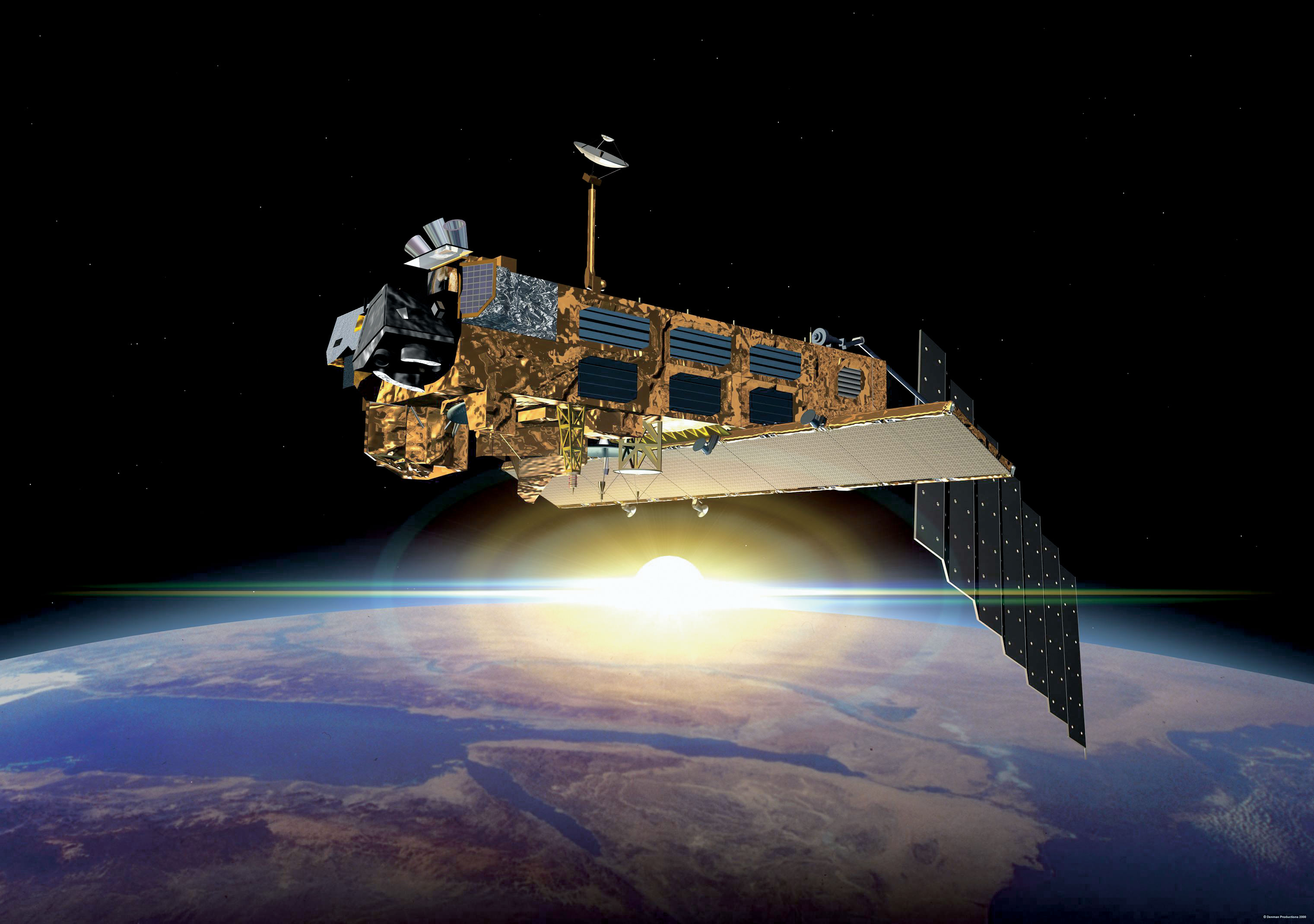
After ten years in orbit Envisat's mission has been declared over. (ESA)
[/caption]
Well, it’s official. After ten years of groundbreaking observation of our planet, ESA has declared the end of the Envisat mission after losing contact with the satellite on April 8, 2012. All attempts to re-establish communication with Envisat have so far been unsuccessful, and although recovery teams will continue to determine the cause of signal loss and try to regain a signal over the next several weeks, the mission — and the satellite — have been retired.
Having performed twice as long as originally planned, the hardworking Envisat has definitely earned its rest.
On April 8, the European Space Agency lost communication with the Earth-observation satellite, preventing reception of data as it passed over the Kiruna station in Sweden. Although later confirmed that the satellite is still in orbit, the recovery team has not been able to re-establish contact.
It’s thought that a loss of a power regulator could be blocking telemetry and telecommands from reaching Envisat, or else the satellite may have experienced a short-circuit and attempted to go into “safe mode” but experienced difficulties during the transition, leaving it in an unknown state.
ESA states that the chances of ever regaining communication with Envisat are extremely low.
While we had reported before on the last image received before falling silent, the image below is actually the final image from Envisat, an X-band image of the Canary Islands.
The final image from Envisat, acquired on April 8, 2012. (ESA/Edisoft)
During its lifetime, Envisat completed 50,000 orbits of Earth and returned over a thousand terabytes of data, containing invaluable measurements of our planet’s surface and atmosphere that were used in more than 2500 science publications.
The video below gives a fitting eulogy for a satellite that’s definitely overachieved and over-performed, giving us a decade of crucial observations of our world from orbit.
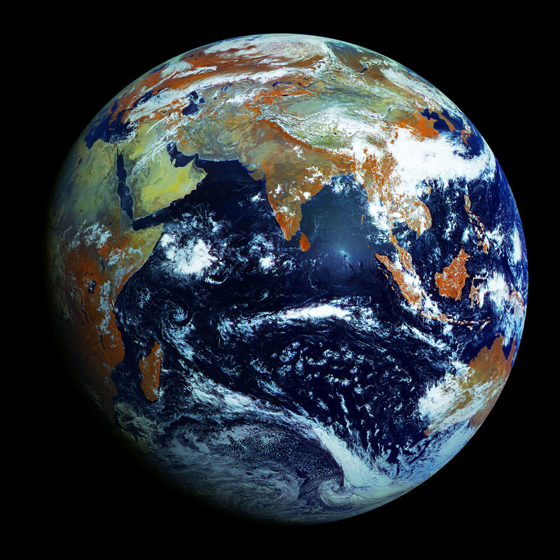
Full-disk image of Earth from Russia's Elektro-L satellite. (NTs OMZ)
[/caption]
Unlike most satellite images of Earth, this one was not assembled from multiple swath scans or digitally projected onto a globe model — it’s the full disk of our planet in captured as a single, enormous 121 megapixel image, acquired by Russia’s Elektro-L weather-forecasting satellite.
Like NASA’s GOES satellites, Elektro-L is parked in a geostationary orbit approximately 36,000 km (22,300 miles) above our planet. Unlike NASA’s satellites, however, Elektro-L captures images in near-infrared as well as visible wavelengths, providing detail about not only cloud movement but also vegetation variations. Its wide-angle Multichannel Scanning Unit (MSU) takes images every 15-30 minutes, showing the same viewpoint of Earth across progressive times of the day.
At a resolution of 0.62 miles per pixel, full-size Elektro-L images are some of the most detailed images of Earth acquired by a weather satellite.
Download the full-size image here (100+ megabytes).
Launched aboard a Zenit rocket on January 20, 2011, Elektro-L was the first major spacecraft to be developed in post-Soviet Russia. Parked over Earth at 76 degrees east longitude, Elektro-L provides local and global weather forecasting and analysis of ocean conditions, as well as “space weather” monitoring — measurements of solar radiation and how it interacts with Earth’s magnetic field. Its initial lifespan is projected to be ten years.
A second Elektro-L satellite is anticipated to launch in 2013.
Image credit: Russian Federal Space Agency / Research Center for Earth Operative Monitoring (NTS OMZ). See more images and video from Elektro-L on James Drake’s Planet Earth here. (Tip of the geostationary hat to Jesus Diaz at Gizmodo.)
All the water on Earth would fit into a sphere 860 miles (1,385 km) wide. (Jack Cook/WHOI/USGS)
[/caption]
If you were to take all of the water on Earth — all of the fresh water, sea water, ground water, water vapor and water inside our bodies — take all of it and somehow collect it into a single, giant sphere of liquid, how big do you think it would be?
According to the U. S. Geological Survey, it would make a ball 860 miles (1,385 km) in diameter, about as wide edge-to-edge as the distance between Salt Lake City to Topeka, Kansas. That’s it. Take all the water on Earth and you’d have a blue sphere less than a third the size of the Moon.
Feeling a little thirsty?
And this takes into consideration all the Earth’s water… even the stuff humans can’t drink or directly access, like salt water, water vapor in the atmosphere and the water locked up in the ice caps. In fact, if you were to take into consideration only the fresh water on Earth (which is 2.5% of the total) you’d get a much smaller sphere… less than 100 miles (160 km) across.
Even though we think of reservoirs, lakes and rivers when we picture Earth’s fresh water supply, in reality most of it is beneath the surface — up to 2 million cubic miles (8.4 million cubic km) of Earth’s available fresh water is underground. But the vast majority of it — over 7 million cubic miles (29.2 cubic km) is in the ice sheets that cover Antarctica and Greenland.
Of course, the illustration above (made by Jack Cook at the Woods Hole Oceanographic Institution) belies the real size and mass of such a sphere of pure liquid water. The total amount of water contained within would still be quite impressive — over 332.5 million cubic miles (1,386 cubic km)! (A single cubic mile of water equals 1.1 trillion gallons.) Still, people tend to be surprised at the size of such a hypothetical sphere compared with our planet as a whole, especially when they’ve become used to the description of Earth as a “watery world”.
Makes one a little less apt to take it for granted.
Read more on the USGS site here, and check out some facts on reducing your water usage here.
Water, water, every where,
And all the boards did shrink;
Water, water, every where,
Nor any drop to drink.
– from The Rime of the Ancient Mariner, Samuel Taylor Coleridge
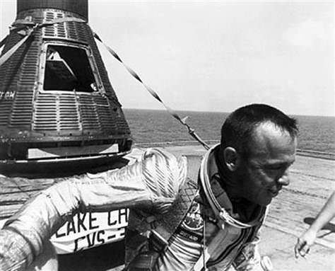
Alan Shepard on board the deck of the USS Champlain after recovery of Freedom 7. Credit: NASA
51 years ago today, on May 5, 1961, NASA launched the Mercury-Redstone 3 rocket carrying Alan B. Shepard, Jr. aboard the Freedom 7 capsule. Shepard successfully became America’s first man in space, making a brief but historic suborbital test flight that propelled American astronauts into the space race of the 1960s.
The video above is made from photographs taken by a film camera mounted to the Freedom 7 spacecraft and scanned by archivists at Johnson Space Center. It shows the view from Freedom 7 as the Redstone rocket launched it into space, getting an amazing view of Earth’s limb and the blackness beyond before falling back to splash down in the Atlantic.
The video is made from the entire film reel, so at the end there’s also some shots of a light experiment inside the spacecraft. (View the individual scans at ASU’s March to the Moon website here.)
What’s amazing to realize is that, at this point in time, the space surrounding our planet was a very empty place. This was a time before communication and weather satellites, before GPS, before Space Station and space shuttles — and space junk — and student-made weather balloon videos. Just 51 years ago low-Earth orbit was a new frontier, and guys like Shepard (and Gagarin and Glenn, etc.) were blazing the path for everyone that followed.
Even though images of Earth from space are still amazing to look at today, seeing these photos reminds us of a time when it was all just so very new.
Read more about Shepard and the MR-3 launch here.
Images and video: NASA/JSC/Arizona State University
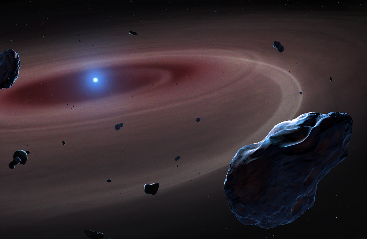
Astronomers have found four nearby white dwarf stars surrounded by disks of material that could be the remains of rocky planets much like Earth — and one star in particular appears to be in the act of swallowing up what’s left of an Earthlike planet’s core.
The research, announced today by the Royal Astronomical Society, gives a chilling look at the eventual fate that may await our own planet.
Astronomers from the University of Warwick used Hubble to identify the composition of four white dwarfs’ atmospheres, found during a survey of over 80 such stars located within 100 light-years of the Sun. What they found was a majority of the material was composed of elements found in our own Solar System: oxygen, magnesium, silicon and iron. Together these elements make up 93% of our planet.
In addition, a curiously low ratio of carbon was identified, indicating that rocky planets were at one time in orbit around the stars.
Since white dwarfs are the leftover cores of stellar-mass stars that have burnt through all their fuel, the material in their atmosphere is likely the leftover bits of planets. Once held in safe, stable orbits, when their stars neared the ends of their lives they expanded, possibly engulfing the innermost planets and disrupting the orbits of others, triggering a runaway collision effect that eventually shattered them all, forming an orbiting cloud of debris.
This could very well be what happens to our Solar System in four or five billion years.
“What we are seeing today in these white dwarfs several hundred light years away could well be a snapshot of the very distant future of the Earth,” said Professor Boris Gänsicke of the Department of Physics at the University of Warwick, who led the study. “During the transformation of the Sun into a white dwarf, it will lose a large amount of mass, and all the planets will move further out. This may destabilise the orbits and lead to collisions between planetary bodies as happened in the unstable early days of our solar systems.”
One of the white dwarfs studied, labeled PG0843+516, may even be actively eating the remains of an once-Earthlike world’s core.
The researchers identified an abundance of heavier elements like iron, nickel and sulphur in the atmosphere surrounding PG0843+516. These elements are found in the cores of terrestrial planets, having sunk into their interiors during the early stages of planetary formation. Finding them out in the open attests to the destruction of a rocky world like ours.
Of course, being heavier elements, they will be the first to be accreted by their star.
“It is entirely feasible that in PG0843+516 we see the accretion of such fragments made from the core material of what was once a terrestrial exoplanet,” Prof. Gänsicke said.
It’s an eerie look into a distant future, when Earth and the inner planets could become just some elements in a cloud.
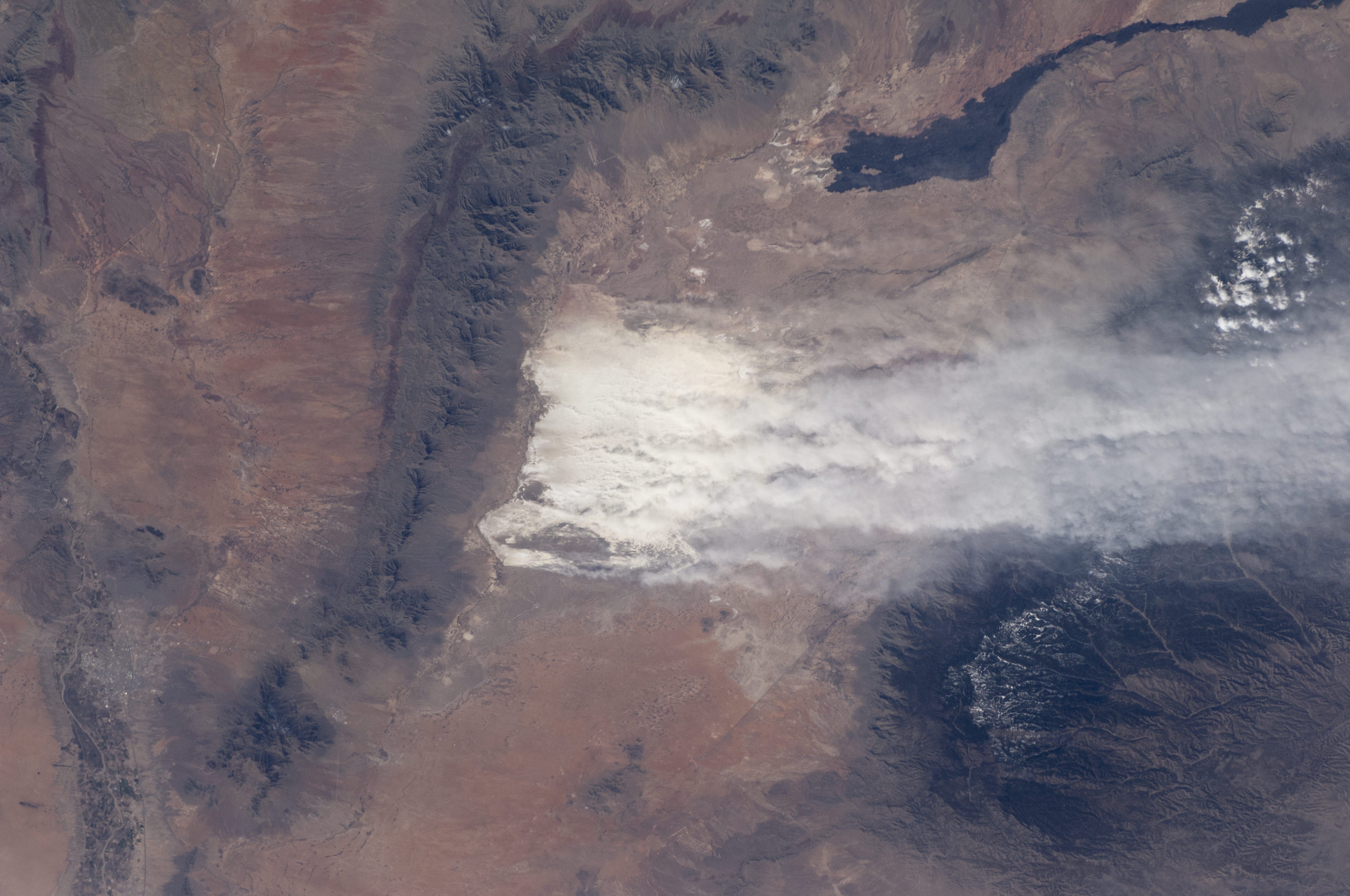
Driven by southwesterly winter winds, dust from the White Sands dune field in New Mexico rises thousands of feet from the valley floor and drifts over the snowy peaks of the Sacramento Mountains. Credit: NASA
[/caption]
It’s clear from this image of why a region in New Mexico, USA is called ‘White Sands.’ The dust plumes in this photograph taken by an astronaut on board the International Space Station show a dust storm in the White Sands National Monument. But this is a huge dust storm. The white dust plumes stretch across more than 120 kilometers (74 miles).
Caused by winds that channel the dust through a low point in the mountains, the vigorous winds are lifting dust particles from the valley floor to more than 1200 meters over the mountains. The Moderate Resolution Imaging Spectroradiometer (MODIS) on NASA’s Aqua satellite also captured a wider, regional view of the same storm on the same day.
The sand dunes of this national monument are white because they are composed of gypsum, a relatively rare dune-forming mineral. The dunes’ brilliance, especially contrasted against the nearby dark mountain slopes, makes them easily identifiable to orbiting astronauts. The white speck of the dunes was even visible to the Apollo astronaut crews looking back at Earth on the way to the Moon.
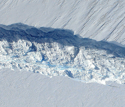
The 820-foot-wide crack in Antarctica's Pine Island Glacier, seen from DC-8 during Operation IceBridge (Credit: NASA/DMS)
Data collected from a NASA ice-watching satellite reveal that the vast ice shelves extending from the shores of western Antarctica are being eaten away from underneath by ocean currents, which have been growing warmer even faster than the air above.
The animation above shows the circulation of ocean currents around the western Antarctic ice shelves. The shelf thickness is indicated by the color; red is thicker (greater than 550 meters), while blue is thinner (less than 200 meters).
Launched in January 2003, NASA’s ICESat (Ice, Cloud and land Elevation Satellite) studied the changing mass and thickness of Antarctica’s ice from its location in polar orbit. An international research team used over 4.5 million surface height measurements collected by ICESat’s GLAS (Geoscience Laser Altimeter System) instrument from Oct. 2005 to 2008. They concluded that 20 of the 54 shelves studied — nearly half — were losing thickness from underneath.
[/caption]
Most of the melting ice shelves are located in west Antarctica, where the flow of inland glaciers to the sea has also been accelerating — an effect that can be compounded by thinning ice shelves which, when grounded to the offshore seabed, serve as dams to hold glaciers back.
Melting of ice by ocean currents can occur even when air temperature remains cold, maintaining a steady process of ice loss — and eventually increased sea level rise.
“We can lose an awful lot of ice to the sea without ever having summers warm enough to make the snow on top of the glaciers melt,” said Hamish Pritchard of the British Antarctic Survey in Cambridge and the study’s lead author . “The oceans can do all the work from below.”
The study also found that Antarctica’s winds are shifting in response to climate change.
“This has affected the strength and direction of ocean currents,” Pritchard said. “As a result warm water is funnelled beneath the floating ice. These studies and our new results suggest Antarctica’s glaciers are responding rapidly to a changing climate.”
ICESat completed operations in 2010 and was decommissioned in August of that year. Its successor ICESat-2 is anticipated to launch in 2016.
This is an artist’s depiction of a 10-kilometer (6-mile) diameter asteroid striking the Earth. New evidence in Australia suggests an asteroid 2 to 3 times larger than this struck Earth early in its life. Credit: Don Davis/Southwest Research Institute.
[/caption]
Even though the Late Heavy Bombardment is somewhat of a controversial idea, new research has revealed this period of impacts to the Earth-Moon system may have lasted much longer than originally estimated and well into the time when early life was forming on Earth. Additionally, this “late-late” period of impacts — 3.8 billion to 2.5 billion years ago — was not for the faint of heart. Various blasts may have rivaled those that produced some of the largest craters on the Moon, and could have been larger than the dinosaur-killing impact that created the Chicxulub crater 65 million years ago.
“Our work provides a rationale that the last big impacts hit over an extended time,” said William Bottke principal investigator of the impact study team at the NASA Lunar Science Institute’s Center of Lunar Origin and Evolution (CLOE), based at the Southwest Research Institute (SwRI) in Boulder, Colorado.
The evidence for these prodigious impacts comes from bead-like impact ‘spherules’ found in millimeter- to centimeter-thick rock layers on Earth and date from the Archean period of Earth’s history, more recent than the estimated LHB period of 4.1 to 3.8 billion years ago.
“The beds speak to an intense period of bombardment of Earth,” Bottke said. “Their source long has been a mystery.”
The millimeter-scale circles and more irregular gray particles are formerly molten droplets ejected into space when an asteroid hit the early Earth. The image at left is from the Monteville layer in South Africa. Courtesy Bruce Simonson, Oberlin College and Conservatory
The circles seen in the image above are all formerly molten droplets ejected into space when an asteroid struck the Earth about 2.56 billion years ago. The droplets returned to Earth and were concentrated at the base of the Reivilo layer in South Africa.
The spherules still contain substantial extraterrestrial material, such as iridium (176 parts per million), which rules out alternative sources for the spherules, such as volcanoes, according to Bruce Simonson, a geologist from the Oberlin College and Conservatory who has studied these ancient layers for decades.
The timing of these impacts also coincides with a record of large lunar craters being created more recently than 3.8-billion years ago.
At least 12 spherule beds deposited between 3.47 and 1.7 billion years ago have been found in protected areas on Earth, such as in shales deposited on the seafloor below the reach of waves.
From these beds, the team found evidence of approximately 70 impacts on Earth during this time period that were likely larger than the Chicxulub impact.
In their paper, which was published in Nature, the team created a computer model of the ancient main asteroid belt and tracked what would have happened when the orbits of the giant planets changed. They extended the work of the Nice Model, which supports the theory that Jupiter, Saturn, Uranus and Neptune formed in different orbits nearly 4.5 billion years ago and migrated to their current orbits about 4 billion years ago, triggering a solar system-wide bombardment of comets and asteroids called known as the LHB.
This image shows a representation of how the giant planets have migrated to the current orbits, destabilizing the extension of the primordial asteroid belt closest to Mars. This drove numerous big impactors onto orbits where they could hit the terrestrial planets, though over a long enough time span that this drawn-out barrage may have lasted more than a billion years. The frequency of these impacts on Earth was enough to reproduce the known impact spherule beds. Image Courtesy David Kring, Center for Lunar Science and Exploration, and the Lunar and Planetary Institute
The new computer model shows that the innermost portion of the asteroid belt could have become destabilized, delivering numerous big impacts to Earth and Moon over longer time periods.
Have there been any previous indications about this period of impacts?
“The problem is that we have almost no Archean rocks,” Bottke told Universe Today. “The oldest terrestrial craters, Sudbury and Vredefort, are 1.85 and 2.02 billion years old. The spherule beds are our only window into impacts prior to this time.”
Also, Bottke said, the number of people who look for impact spherules is almost equally scarce. “People such as Bruce Simonson, Don Lowe, Gary Byerly, and Frank Kyte, have been carrying on a long, lonely quest to try to get people to consider the implications of their work, which are deeply profound, in my opinion,” Bottke said.
As for finding evidence of this later period of impacts on the Moon, Bottke said the problem there is the lack of solid ages for most impact events.
“This means it is difficult say anything definitive about the timing of major impacts,” Bottke said. “We are working this problem now with Michelle Kirchoff, who is counting craters on top of large lunar craters. This can be done now that we have LRO data.” (Listen to a podcast interview of Kirchoff on the 365 Days of Astronomy.)
Still, Bottke said, without using “fancy dynamics,” they can address some issues.
“Studies in the post-Apollo era suggested that the Moon has four 160-300 km craters that formed after Orientale, whose age is 3.7-3.8 billion years ago and (i.e., K/T-sized events or larger),” he said. “Crater counts from the Galileo mission and Apollo-era geologic analyses suggest at least one of these events took place near 3.2-3.5 billion years ago. If we account for the gravitational cross section of the planets, we know that for every lunar event, we should get about 20 on the Earth. So, from this argument alone, one should get a lot of big impacts on the Earth after the formation of Orientale.”
The new study fits with the available constraints about impacts on the Moon as well as finding the right distribution of spherule beds on Earth.
The best way to confirm everything, however, Bottke said, would be if more lunar rocks from various locations were available for study.
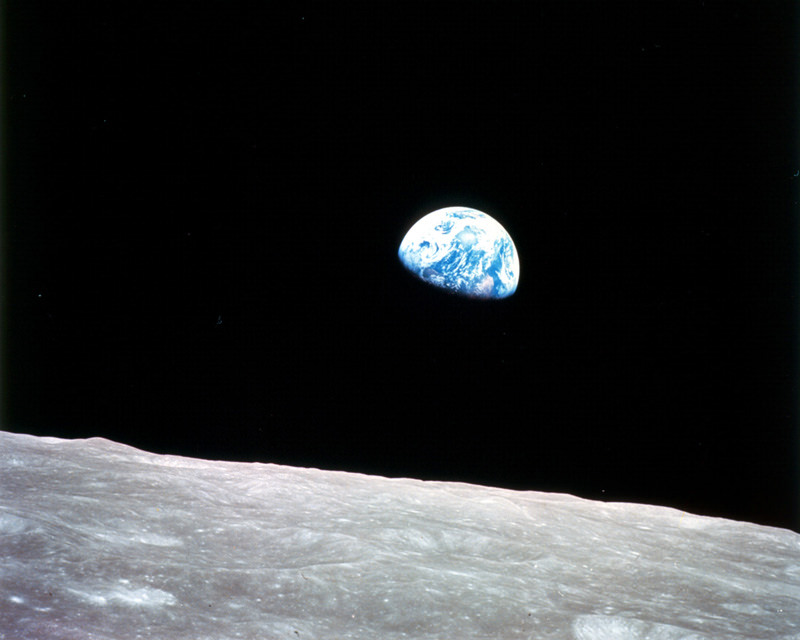
The first color photo of Earth taken from orbit around the Moon. (NASA)
On December 24, 1968, Apollo 8 astronauts Frank Borman, William Anders and Jim Lovell were the first humans to witness an Earthrise as our home planet came up over the lunar horizon. The photos they captured were the first of their kind, instantly inspiring the imaginations of millions and highlighting the beauty and fragility of our world.
Now, NASA has used modern satellite data to recreate the scenes that the Apollo 8 astronauts saw 44 years ago and combined them with their historic photographs to present a new “Earthrise”… version 2.0.
Created in recognition of Earth Day 2012, the Earthrise animation was made from data acquired by NASA’s Lunar Reconnaissance Orbiter’s laser altimeter, as well as the Moderate Resolution Imaging Spectroradiometer (MODIS) on the Terra Earth-observing satellite.
“This visualization recreates for everyone the wondrous experience of seeing Earth from that privileged viewpoint,” says LRO Project Scientist Rich Vondrak of NASA’s Goddard Space Flight Center.
Animator Ernie Wright recreated the scene using Apollo mission reports and photos taken by the crew. The audio is a recording of original communication from the astronauts.
[/caption]
“I think the one overwhelming emotion that we had was when we saw the earth rising in the distance over the lunar landscape… it makes us realize that we all do exist on one small globe. For from 230,000 miles away it really is a small planet.”
In honor of Earth Day, enjoy this beautiful timelapse compiled by science educator James Drake, who put together one of the first ISS flyover videos. This video was created from images produced by the Russian geostationary Electro-L Weather Satellite, and the images are some of the largest whole disk images of our planet, as the satellite is orbiting at about 40,000 km. Each image is 121 megapixels, and the resolution is 1 kilometer per pixel. They are taken every half hour in four different wavelengths of light — three visible, and one infrared. The infrared light is reflected by forests and vegetation, which appear orange in these images. Enjoy!
See more at Drake’s Planet Earth web page, including a zoomable, full resolution image of Earth, as well as other image downloads.