NASA Satellite Sees Ghostly Remains of Vanishing Arctic Sea Ice

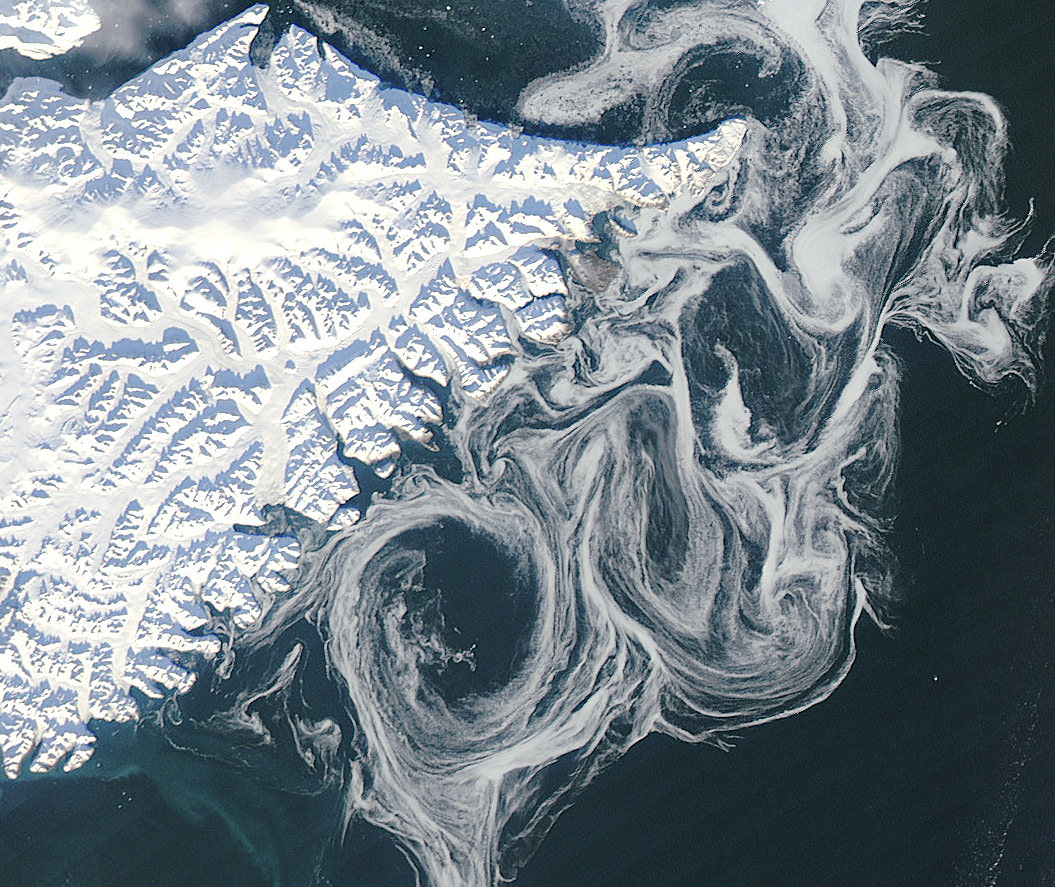
Sea ice swirls in ocean currents off the coast of Greenland (NASA/GSFC)

Spooky spectral swirls of last season’s sea ice drift in currents off the coast of eastern Greenland in this image from NASA’s Aqua satellite, acquired on October 17. Although sea ice in the Arctic will start forming again after September’s record low measurements, these ghostly wisps are likely made up of already-existing ice that has migrated south.

As global temperatures rise — both over land and in the ocean — thinner sea ice builds up during the Arctic winter and thus more of it melts during the summer, a pattern that will eventually lead to an ice-free Arctic if trends continue. The past several years saw sea ice in the Arctic below the 1979-2000 average, with this past September displaying the lowest volumes yet recorded.

The graph below, made from data modeled by the Polar Science Center at the University of Washington, show the chilling — or, perhaps, not-so-chilling — results of this century’s recent observations.

Along Greenland’s east coast, the Fram Strait serves as an expressway for sea ice moving out of the Arctic Ocean. The movement of ice through the strait used to be offset by the growth of ice in the Beaufort Gyre.

Until the late 1990s, ice would persist in the gyre for years, growing thicker and more resistant to melt. Since the start of the twenty-first century, however, ice has been less likely to survive its trip through the southern part of the Beaufort Gyre. As a result, less Arctic sea ice has been able to pile up and form multi-year ice.

Thin, free-drifting ice — as seen above — moves very easily with winds and currents.

Aqua is a NASA Earth Science satellite mission named for the large amount of information that the mission is collecting about the Earth’s water cycle, including evaporation from the oceans, water vapor in the atmosphere, clouds, precipitation, soil moisture, sea ice, land ice, and snow cover on the land and ice. Aqua was launched on May 4, 2002, and carries six Earth-observing instruments in a near-polar low-Earth orbit. MODIS, which acquired the image above, is a 36-band spectroradiometer that measures physical properties of the atmosphere, oceans and land.

Source: NASA Earth Observatory

NASA image courtesy Jeff Schmaltz, LANCE MODIS Rapid Response Team at NASA GSFC. Graph by Jesse Allen based on modeled ice volume data from the Polar Science Center, University of Washington. Caption portions by Michon Scott with information from Ted Scambos, National Snow and Ice Data Center.

Watch: Incredible Headcam Video from Felix’s Freefall

Felix Baumgartner salutes his suit-mounted camera before stepping off his capsule’s platform at 128,000 feet (Red Bull Stratos)

Yesterday, October 14, Austrian pilot and BASE jumper Felix Baumgartner became the first person to skydive from over 128,000 feet, breaking the sound barrier during his 4 minute, 20 second plummet from the “edge of space.” A new video from Red Bull Stratos includes views from Felix’s suit-mounted cameras as he drops through virtually no atmosphere, smoothly at first but then going into a wild spin… but eventually stabilizing himself for the remainder of his fall and opening his chute at just over 6,000 feet. Incredible!

Check out the video below:

Here’s how Baumgartner described the spin and how he got out of it during the press conference after his jump yesterday:

“It started out really good because my exit was perfect, I did exactly what I was supposed to do… It looked like for a second I was going to tumble two more times and then get it under control, but for some reason that spin became so violent over all axis and it was hard to know how to get out of it, because, if you are trapped in a pressurized suit – normally as a skydiver you can feel the air and get direct feedback from the air — but here you are trapped in a suit that is pressurized at 3.5 PSI so you don’t know how to feel the air. It is like swimming without touching the water. And it’s hard because every when time it turns you around you have to figure out what to do. So I was sticking my arm out and it became worse and then I stuck arm out the other side and it became less, so I was fighting all the way down to regain control because I wanted to break the speed of sound. And I hit it. I don’t know how many seconds, but I could feel air was building up and then I hit it.”

So, in that quote, Baumgartner seemed to describe that he could feel when he broke the speed of sound, but in answering the next question of how it felt, he kind of backtracked and said he didn’t feel it.

“It’s hard to describe because I didn’t feel it. When you are in the pressure suit, you don’t feel anything, it is like being in a cast…. We have to look at the data – at what point did it happen — was I still spinning or was I under control? If you want to chart speed you need a reference point of things that pass you by, or sound, or your suit if flapping. I didn’t have that.”

Read more about Baumgartner’s record (and sound!) -breaking achievement and see lots more images and video here.

ADDED: A version of the video showing his chute opening (and with some background music added) can be found here on iloveskydiving.org.

35 Years Ago: Our First Family Portrait of the Earth and Moon

A crescent Earth and Moon as seen by Voyager 1 on September 18, 1977 (NASA)

35 years ago today, September 18, 1977, NASA’s Voyager 1 spacecraft turned its camera homeward just about two weeks after its launch, capturing the image above from a distance of 7.25 million miles (11.66 million km). It was the first time an image of its kind had ever been taken, showing the entire Earth and Moon together in a single frame, crescent-lit partners in space.

The view of Earth shows eastern Asia, the western Pacific Ocean and part of the Arctic. Voyager 1 was actually positioned directly above Mt. Everest when the images were taken (the final color image was made from three separate images taken through color filters.)

The Moon was brightened in the original NASA images by a factor of three, simply because Earth is so much brighter that it would have been overexposed in the images were they set to expose for the Moon. (Also I extended the sides of the image a bit above to fit better within a square format.)

Read the latest on Voyager 1: Winds of Change at the Edge of the Solar System

Previous images may have shown the Earth and Moon together, but they were taken from orbit around one or the other and as a result didn’t have both worlds fully — and in color! — within a single frame like this one does. In fact, it was only 11 years earlier that the very first image of Earth from the Moon was taken, acquired by NASA’s Lunar Orbiter I spacecraft on August 23, 1966.

It’s amazing to think what was happening in the world when Voyager took that image:
• World population was 4.23 billion (currently estimated to be 7.04 billion)
• The Space Shuttle Enterprise made its first test flight from a 747
• Star Wars, Close Encounters of the Third Kind and Saturday Night Fever were out in U.S. theaters
• Charlie Chaplin and Elvis Presley died
• U.S. federal debt was “only” $706 billion (now over $16 trillion!)
• And, of course, both Voyagers launched on their Grand Tour of the Solar System, ultimately becoming the most distant manmade objects in existence
(See more world stats and events here.)

Image: NASA/JPL

“Once a photograph of the Earth, taken from outside, is available – once the sheer isolation of the Earth becomes known – a new idea as powerful as any in history will be let loose.”
– Sir Fred Hoyle

NASA Probes Play the Music of Earth’s Magnetosphere

Launched on August 30, 2012, NASA’s twin Radiation Belt Storm Probe (RBSP) satellites have captured recordings of audible-range radio waves emitted by Earth’s magnetosphere. The stream of chirps and whistles heard in the video above consist of 5 separate occurrences captured on September 5 by RBSP’s Electric and Magnetic Field Instrument Suite and Integrated Science (EMFISIS) instrument.

The events are presented as a single continuous recording, assembled by the (EMFISIS) team at the University of Iowa and NASA’s Goddard Space Flight Center.

Called a “chorus”, this phenomenon has been known for quite some time.

“People have known about chorus for decades,” says EMFISIS principal investigator Craig Kletzing of the University of Iowa. “Radio receivers are used to pick it up, and it sounds a lot like birds chirping. It was often more easily picked up in the mornings, which along with the chirping sound is why it’s sometimes referred to as ‘dawn chorus.’”

The radio waves, which are at frequencies that are audible to the human ear, are emitted by energetic particles within Earth’s magnetosphere, which in turn affects (and is affected by) the radiation belts.

The RBSP mission placed a pair of identical satellites into eccentric orbits that will take them from as low as 375 miles (603 km) to as far out as 20,000 miles (32,186 km). During their orbits the satellites will pass through both the stable inner and more variable outer Van Allen belts, one trailing the other. Along the way they’ll investigate the many particles that make up the belts and identify what sort of activity occurs in isolated locations — as well as across larger areas.

Read: New Satellites Will Tighten Knowledge of Earth’s Radiation Belts

Audio Credit: University of Iowa. Visualisation Credit: NASA/Goddard Space Flight Center. (H/T to Peter Sinclair at climatecrocks.com.)

What Are The Radiation Belts?

NASA’s twin Radiation Belt Storm Probe (RBSP) satellites, scheduled to launch from Cape Canaveral Friday, August 24* at 4:08 a.m. ET, will enter into an eccentric orbit around our planet, repeatedly passing through both of the Van Allen radiation belts that surround Earth like enormous high-intensity particle filled inner tubes. The plasma contained within these belts can affect satellites, spacecraft and communication here on Earth, and are affected in turn by outbursts of solar energy from the Sun — especially during periods of solar maximum. But how do these invisible yet powerful radiation belts actually work, and how will two six-foot-wide satellites help us learn more about them? Watch the video.

(And then read more here.)

Video: NASA

*UPDATE: After several delays due to weather and technical issues, the RBSP mission successfully launched on Thursday, August 30.

On the Hunt for High-Speed Sprites

Air glow (along with a lightning sprite) is visible in this image from the International Space Station. Credit: NASA

A bright red sprite appears above a lightning flash in a photo captured from the ISS

Back on April 30, Expedition 31 astronauts aboard the ISS captured this photo of a red sprite hovering above a bright flash of lightning over Myanmar. Elusive atmospheric phenomena, sprites are extremely brief bursts of electromagnetic activity that are associated with powerful lightning discharges, but exactly how and why they form isn’t yet known — although recent research (along with some incredible high-speed video) is shedding new light on sprites.

Although the appearance of bright high-altitude flashes above thunderstorms have been reported by pilots for nearly a century, it wasn’t until 1989 that a sprite was captured on camera — and the first color image of one wasn’t taken until 1994.

So-named because of their elusive nature, sprites appear as several clusters of red tendrils above a lighting flash followed by a breakup into smaller streaks, often extending as high as 55 miles (90 km) into the atmosphere. The brightest region of a sprite is typically seen at altitudes of 40-45 miles (65-75 km).

Because they occur above storms, only last for a thousandth of a second and emit light in the red portion of the visible spectrum (to which our eyes are the least sensitive) studying sprites has been notoriously difficult for atmospheric scientists. Space Station residents may get great views but they have lots of other things to do in the course of their day besides sprite hunting! Luckily, a team of scientists were able to capture some unprecedented videos of sprites from airplanes in the summer of 2011, using high-speed cameras and help from Japan’s NHK television.

Chasing storms over Denver via plane for two weeks, researchers were able to locate “hot zones” of sprites and capture them on camera from two planes flying 12 miles apart. Combining their videos with ground-based measurements they were able to create 3-dimensional maps of the formation and evolution of individual sprites.

Based on the latest research, it’s suggested that sprites form as a result of a positive electrical charge within a lightning strike that reaches the ground, which leaves the top of the cloud negatively charged — a one-in-ten chance that then makes conditions above the cloud “just right” for a sprite to form higher in the atmosphere.

“Seeing these are spectacular,” said Hans C. Stenbaek-Nielsen, a geophysicist at the University of Alaska in Fairbanks, Alaska, where much sprite research has been conducted. “But we need the movies, because not only are they so fast that you could blink and miss them, but they emit most of their light in red, where the human eye is relatively blind.”

An example of how energy can be exchanged between lower and higher regions of Earth’s atmosphere, it’s been suggested that sprites could also be found on other planets as well, and may provide insight into the exotic chemistries of alien atmospheres.

Read more on NASA Heliophysics here.

Main image: Image Science & Analysis Laboratory, NASA Johnson Space Center. Inset image: the first color image of a sprite  (NASA/UAF.) Video: NHK.

New Satellites Will Tighten Knowledge of Earth’s Radiation Belts


Surrounding our planet like vast invisible donuts (the ones with the hole, not the jelly-filled kind) are the Van Allen radiation belts, regions where various charged subatomic particles get trapped by Earth’s magnetic fields, forming rings of plasma. We know that the particles that make up this plasma can have nasty effects on spacecraft electronics as well as human physiology, but there’s a lot that isn’t known about the belts. Two new satellites scheduled to launch on August 23 August 24 will help change that.

“Particles from the radiation belts can penetrate into spacecraft and disrupt electronics, short circuits or upset memory on computers. The particles are also dangerous to astronauts traveling through the region. We need models to help predict hazardous events in the belts and right now we are aren’t very good at that. RBSP will help solve that problem.”
– David Sibeck, RBSP project scientist, Goddard Space Flight Center

NASA’s Radiation Belt Storm Probes (RBSP) mission will put a pair of identical satellites into eccentric orbits that take them from as low as 375 miles (603 km) to as far out as 20,000 miles (32,186 km). During their orbits the satellites will pass through both the stable inner and more variable outer Van Allen belts, one trailing the other. Along the way they’ll investigate the many particles that make up the belts and identify what sort of activity occurs in isolated locations and across larger areas.

“Definitely the biggest challenge that we face is the radiation environment that the probes are going to be flying through,” said Mission Systems Engineer Jim Stratton at APL. “Most spacecraft try to avoid the radiation belts — and we’re going to be flying right through the heart of them.”

Read: The Van Allen Belts and the Great Electron Escape

Each 8-sided RBSP satellite is approximately 6 feet (1.8 meters) across and weighs 1,475 pounds (669 kg).

The goal is to find out where the particles in the belts originate from — do they come from the solar wind? Or Earth’s own ionosphere? — as well as to find out what powers the belts’ variations in size and gives the particles their extreme speed and energy. Increased knowledge about Earth’s radiation belts will also help in the understanding of the plasma environment that pervades the entire Universe.

Read: What Are The Radiation Belts?

Ultimately the information gathered by the RBSP mission will help in the design of future science and communications satellites as well as safer spacecraft for human explorers.

The satellites are slated to launch aboard a United Launch Alliance Atlas V rocket from Cape Canaveral Air Force Station no earlier than 4:08 a.m. EDT on August 24.

Find out more about the RBSP mission here.

Video/rendering: NASA/GSFC.

New Stunning ISS Time-lapse: Earth Illuminated

“If you could see the Earth illuminated when you were in a place as dark as night, it would look to you more spendid than the Moon.”

— Galileo Galilei.

400 years ago, Galileo could only imagine what the view of Earth would be like from space. Today, we have people on board the International Space Station who see that view every day. This new beautiful time-lapse shows aurora, lightning, our Milky Way Galaxy, city lights and other sights as seen from orbit.

Below is a great still image from this video, an amazing look through the ISS’s Cupola as Earth whizzes by:

Image caption: A view out the Cupola of the ISS. Credit: NASA

For more time-lapse videos and imagery, visit NASA’s Gateway to Astronaut Photography of Earth website.

An Orbital Adagio: Nighttime Views from the ISS

People keep making these videos from ISS photography, and we keep loving them. Here’s the latest, assembled by photographer Knate Myers to a track by John Murphy (from the movie soundtrack for Sunshine) it’s a beautiful tour of nighttime passes of the Space Station over our planet. Stars, city lights, airglow, aurorae… it’s nothing you haven’t seen before, but everything worth seeing again. Watch it.

Video: Knate Myers. All images courtesy of the Image Science & Analysis Laboratory, NASA Johnson Space Center. Via the Gateway to Astronaut Photography of Earth.

Brazilian Band Soars to New Heights with a NASA-Inspired Video


Popular Brazilian rock band Fresno recently released a new video for their new song, “Infinito”, and it really rises above the rest — literally!

It’s a story of four guys who take their childhood dream of launching a package up into space and, after years apart, come back together to make it a reality. Along the way we get to see some great views from a camera that the band members actually sent up to the edge of space via weather balloon — an accomplishment that came with its fair share of challenges.

Fresno lead member Lucas Silveira shared some behind-the-scenes info with Universe Today. “We wasted two cameras. One of them landed on a military base — exactly in the middle of a mine field — and the other simply disappeared… completely lost due to the lack of cellular signal on the landing spot.”

And even on a successful third try there were some technical difficulties.

“In our third attempt we used a different balloon, with more capacity, and it managed to fly for over 3.5 hours… but our camera only survived for around 2.5 hours. So we had to send a smaller balloon just to capture the ‘popping up’ moment, and added it to the ‘main balloon ride’ on post production.”

Still, the results — a dizzying view of Earth from 35 km up — are well worth it, and the story is an inspiring one… inspired, in fact, by NASA.

“I wrote this song after watching a video by NASA in which they zoom out from the Himalayas to the edge of the universe, showing the areas that still yet to be mapped. We are so infinitely small in the middle of all this greatness, and suddenly our problems get as tiny in our heads as our lucky existence here. It’s about searching for better days, creating a better future through proactivity and not letting others letting you down.”

When you soar that high it’s hard to feel let down.

Video courtesy of Fresno. Technical and launch assistance provided by ACRUX Aerospace Technologies. Band photo by Gustavo Vara.