New Horizons trajectory and the orbits of Pluto and 2014 MU69.
New Horizons trajectory and the orbits of Pluto and 2014 MU69.
In an ‘Independence Day’ gift to a slew of US planetary research scientists, NASA has granted approval to nine ongoing missions to continue for another two years this holiday weekend.
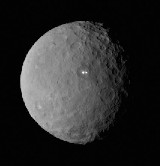
The biggest news is that NASA green lighted a mission extension for the New Horizons probe to fly deeper into the Kuiper Belt and decided to keep the Dawn probe at Ceres forever, rather than dispatching it to a record breaking third main belt asteroid.
And the exciting extension news comes just as the agency’s Juno probe is about to ignite a do or die July 4 fireworks display to achieve orbit at Jupiter – detailed here.
“Mission approved!” the researchers gleefully reported on the probes Facebook and Twitter social media pages.
“Our extended mission into the #KuiperBelt has been approved. Thanks to everyone for following along & hopefully the best is yet to come.
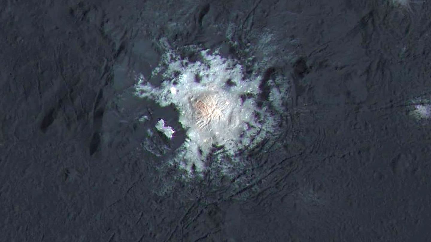
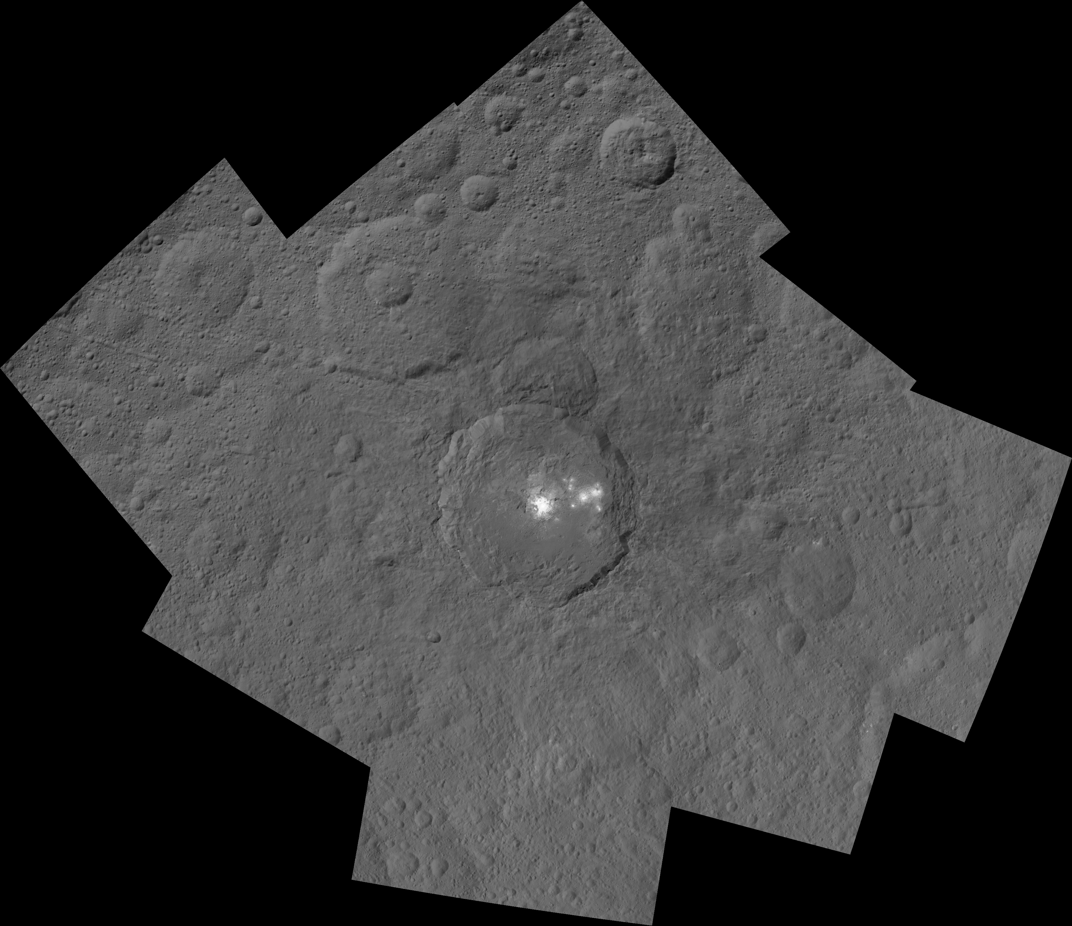
Dwarf planet Ceres is shown in this false-color renderings, which highlight differences in surface materials. The image is centered on Ceres brightest spots at Occator crater. Image credit: NASA/JPL-Caltech/UCLA/MPS/DLR/IDA
The New Horizons spacecraft will now continue on course in the Kuiper Belt towards an small object known as 2014 MU69, to carry out the most distant close encounter with a celestial object in human history.
“Here’s to continued success!”
The spacecraft will rendezvous with the ancient rock on New Year’s Day 2019.
Researchers say that 2014 MU69 is considered as one of the early building blocks of the solar system and as such will be invaluable to scientists studying the origin of our solar system how it evolved.
It was almost exactly one year ago on July 14, 2015 that New Horizons conducted Earth’s first ever up close flyby and science reconnaissance of Pluto – the most distant planet in our solar system and the last of the nine planets to be explored.
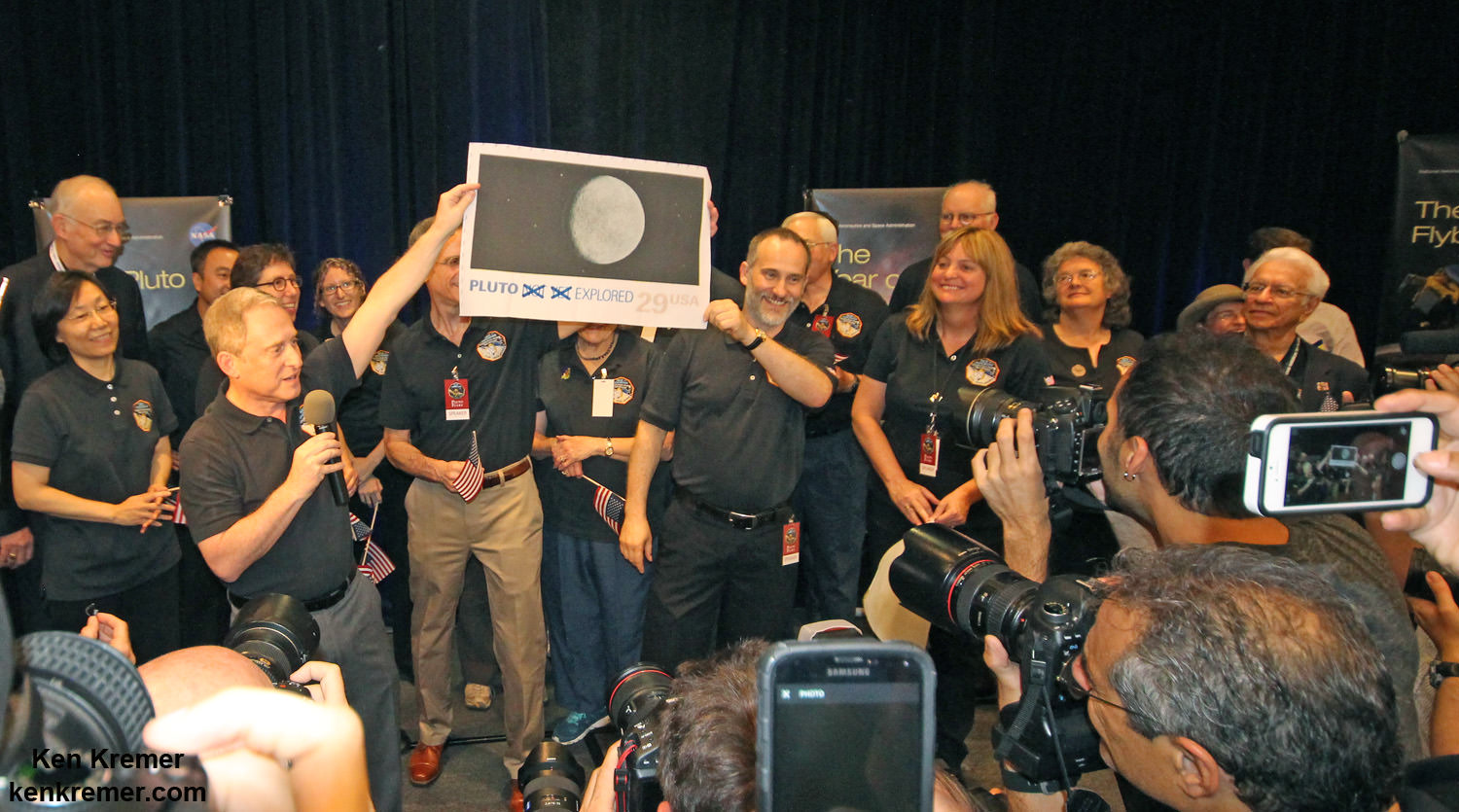
Pluto Explored at Last. The New Horizons mission team celebrates successful flyby of Pluto in the moments after closest approach at 7:49 a.m. EDT on July 14, 2015. New Horizons Principal Investigator Alan Stern of Southwest Research Institute (SwRI), Boulder, CO., left, Johns Hopkins University Applied Physics Laboratory (APL) Director Ralph Semmel, center, and New Horizons Co-Investigator Will Grundy Lowell Observatory hold an enlarged print of an U.S. stamp with their suggested update after Pluto became the final planet in our solar system to be explored by an American space probe (crossing out the words ‘not yet’) – at the Johns Hopkins University Applied Physics Laboratory (APL) in Laurel, Maryland. Credit: Ken Kremer/kenkremer.com
The immense volume of data gathered continues to stream back to Earth every day.
“The New Horizons mission to Pluto exceeded our expectations and even today the data from the spacecraft continue to surprise,” said NASA’s Director of Planetary Science Jim Green at NASA HQ in Washington, D.C.
“We’re excited to continue onward into the dark depths of the outer solar system to a science target that wasn’t even discovered when the spacecraft launched.”
This new global mosaic view of Pluto was created from the latest high-resolution images to be downlinked from NASA’s New Horizons spacecraft and released on Sept. 11, 2015. The images were taken as New Horizons flew past Pluto on July 14, 2015, from a distance of 50,000 miles (80,000 kilometers). This new mosaic was stitched from over two dozen raw images captured by the LORRI imager and colorized. Annotated with informal place names. Credits: NASA/Johns Hopkins University Applied Physics Laboratory/Southwest Research Institute/Marco Di Lorenzo/Ken Kremer/kenkremer.com
While waiting for news on whether NASA would approve an extended mission, the New Horizons engineering and science team already ignited the main engine four times to carry out four course changes in October and November 2015, in order to preserve the option of the flyby past 2014 MU69 on Jan 1, 2019.
Green noted that mission extensions into fiscal years 2017 and 2018 are not final until Congress actually passes sufficient appropriation to fund NASA’s Planetary Science Division.
“Final decisions on mission extensions are contingent on the outcome of the annual budget process.”
Tough choices were made even tougher because the Obama Administration has cut funding for the Planetary Sciences Division – some of which was restored by a bipartisan majority in Congress for what many consider NASA’s ‘crown jewels.’
NASA’s Dawn asteroid orbiter just completed its primary mission at dwarf planet Ceres on June 30, just in time for the global celebration known as Asteroid Day.
“The mission exceeded all expectations originally set for its exploration of protoplanet Vesta and dwarf planet Ceres,” said NASA officials.
The Dawn science team had recently submitted a proposal to break out of orbit around the middle of this month in order to this conduct a flyby of the main belt asteroid Adeona.
Green declined to approve the Dawn proposal, citing additional valuable science to be gathered at Ceres.
The long-term monitoring of Ceres, particularly as it gets closer to perihelion – the part of its orbit with the shortest distance to the sun — has the potential to provide more significant science discoveries than a flyby of Adeona,” he said.
The funding required for a multi-year mission to Adeona would be difficult in these cost constrained times.
However the spacecraft is in excellent shape and the trio of science instruments are in excellent health.
Dawn arrived at Ceres on March 6, 2015 and has been conducting unprecedented investigation ever since.
Dawn is Earth’s first probe in human history to explore any dwarf planet, the first to explore Ceres up close and the first to orbit two celestial bodies.
The asteroid Vesta was Dawn’s first orbital target where it conducted extensive observations of the bizarre world for over a year in 2011 and 2012.
The mission is expected to last until at least later into 2016, and possibly longer, depending upon fuel reserves.
Due to expert engineering and handling by the Dawn mission team, the probe unexpectedly has hydrazine maneuvering fuel leftover.
Dawn will remain at its current altitude at the Low Altitude Mapping Orbit (LAMO) for the rest of its mission, and indefinitely afterward, even when no further communications are possible.
Green based his decision on the mission extensions on the biannual peer review scientific assessment by the Senior Review Panel.
Dawn was launched in September 2007.
The other mission extensions – contingent on available resources – are: the Mars Reconnaissance Orbiter (MRO), Mars Atmosphere and Volatile EvolutioN (MAVEN), the Opportunity and Curiosity Mars rovers, the Mars Odyssey orbiter, the Lunar Reconnaissance Orbiter (LRO), and NASA’s support for the European Space Agency’s Mars Express mission.
Stay tuned here for Ken’s continuing Earth and planetary science and human spaceflight news.
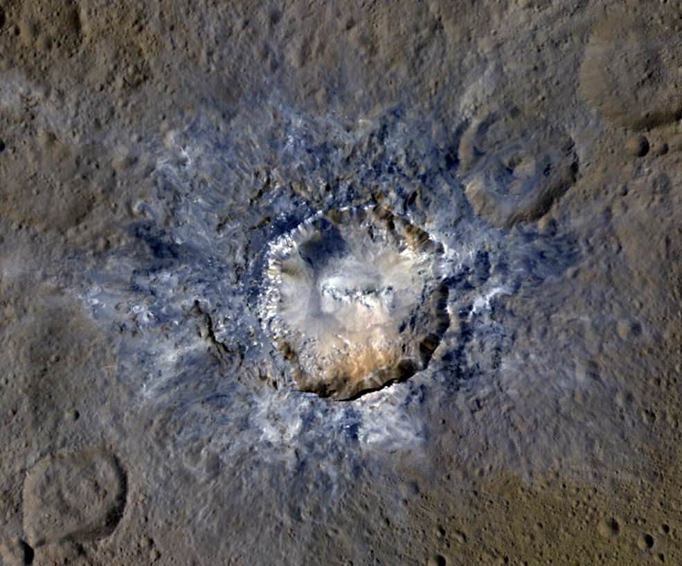
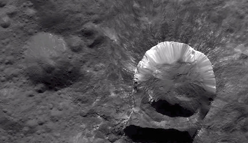
Ceres' Haulani Crater, with a diameter of 21 miles (34 kilometers), shows evidence of landslides from its crater rim. Credits: NASA/JPL-Caltech/UCLA/MPS/DLR/IDA
Ceres’ Haulani Crater, with a diameter of 21 miles (34 kilometers), shows evidence of landslides from its crater rim. Credits: NASA/JPL-Caltech/UCLA/MPS/DLR/IDA
Now in orbit for just over a year at dwarf planet Ceres, NASA’s Dawn spacecraft continues to astound us with new discoveries gleaned from spectral and imagery data captured at ever decreasing orbits as well as since the probe arrived last December at the lowest altitude it will ever reach during the mission.
Mission scientists have just released marvelous new images of Haulani and Oxo craters revealing landslides and mysterious slumps at several of the mysterious bright craters on Ceres – the largest asteroid in the main Asteroid Belt between Mars and Jupiter.
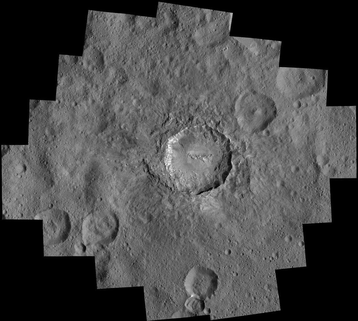
The newly released image of oddly shaped Haulani crater above, shows the crater in enhanced color and reveals evidence of landslides emanating from its crater rim.
“Rays of bluish ejected material are prominent in this image. The color blue in such views has been associated with young features on Ceres,” according to the Dawn science team.
“Enhanced color allows scientists to gain insight into materials and how they relate to surface morphology.”
Look at the image closely and you’ll see its actually polygonal in nature – meaning it resembles a shape made of straight lines – unlike most craters in our solar system which are nearly circular.
”The straight edges of some Cerean craters, including Haulani, result from pre-existing stress patterns and faults beneath the surface,” says the science team.
Haulani Crater has a diameter of 21 miles (34 kilometers) and apparently was formed by an impacting object relatively recently in geologic time and is also one of the brightest areas on Ceres.
“Haulani perfectly displays the properties we would expect from a fresh impact into the surface of Ceres. The crater floor is largely free of impacts, and it contrasts sharply in color from older parts of the surface,” said Martin Hoffmann, co-investigator on the Dawn framing camera team, based at the Max Planck Institute for Solar System Research, Göttingen, Germany, in a statement.
The enhanced color image was created from data gathered at Dawn’s High Altitude Mapping Orbit (HAMO), while orbiting at an altitude of 915 miles (1,470 kilometers) from Ceres.
Data from Dawn’s VIR instrument shows that Haulani’s surface is comprised of different materials than its surroundings.
“False-color images of Haulani show that material excavated by an impact is different than the general surface composition of Ceres. The diversity of materials implies either that there is a mixed layer underneath, or that the impact itself changed the properties of the materials,” said Maria Cristina de Sanctis, the VIR instrument lead scientist, based at the National Institute of Astrophysics, Rome.
Since mid-December, Dawn has been orbiting Ceres in its Low Altitude Mapping Orbit (LAMO), at a distance of 240 miles (385 kilometers) from Ceres, resulting in the most stunning images ever of the dwarf planet.
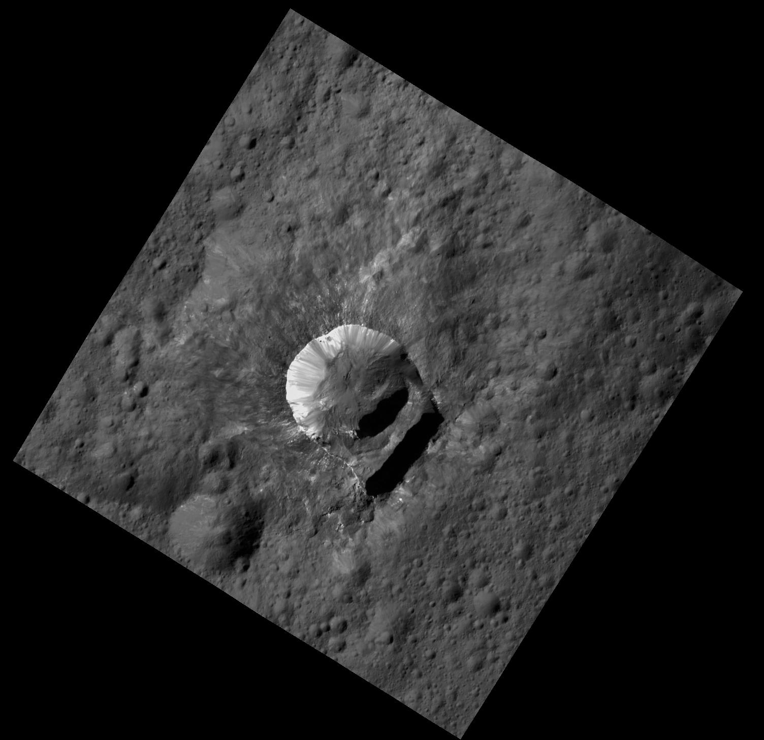
By way of comparison the much higher resolution image of Haulani crater below, is a mosaic of views assembled from multiple images taken from LAMO at less than a third of the HAMO image distance – at only 240 miles (385 kilometers) above Ceres.
Haulani Crater at LAMO. NASA’s Dawn spacecraft took this mosaic view of Haulani Crater at a distance of 240 miles (385 kilometers) from the surface of Ceres. Credits: NASA/JPL-Caltech/UCLA/MPS/DLR/IDA/PSI
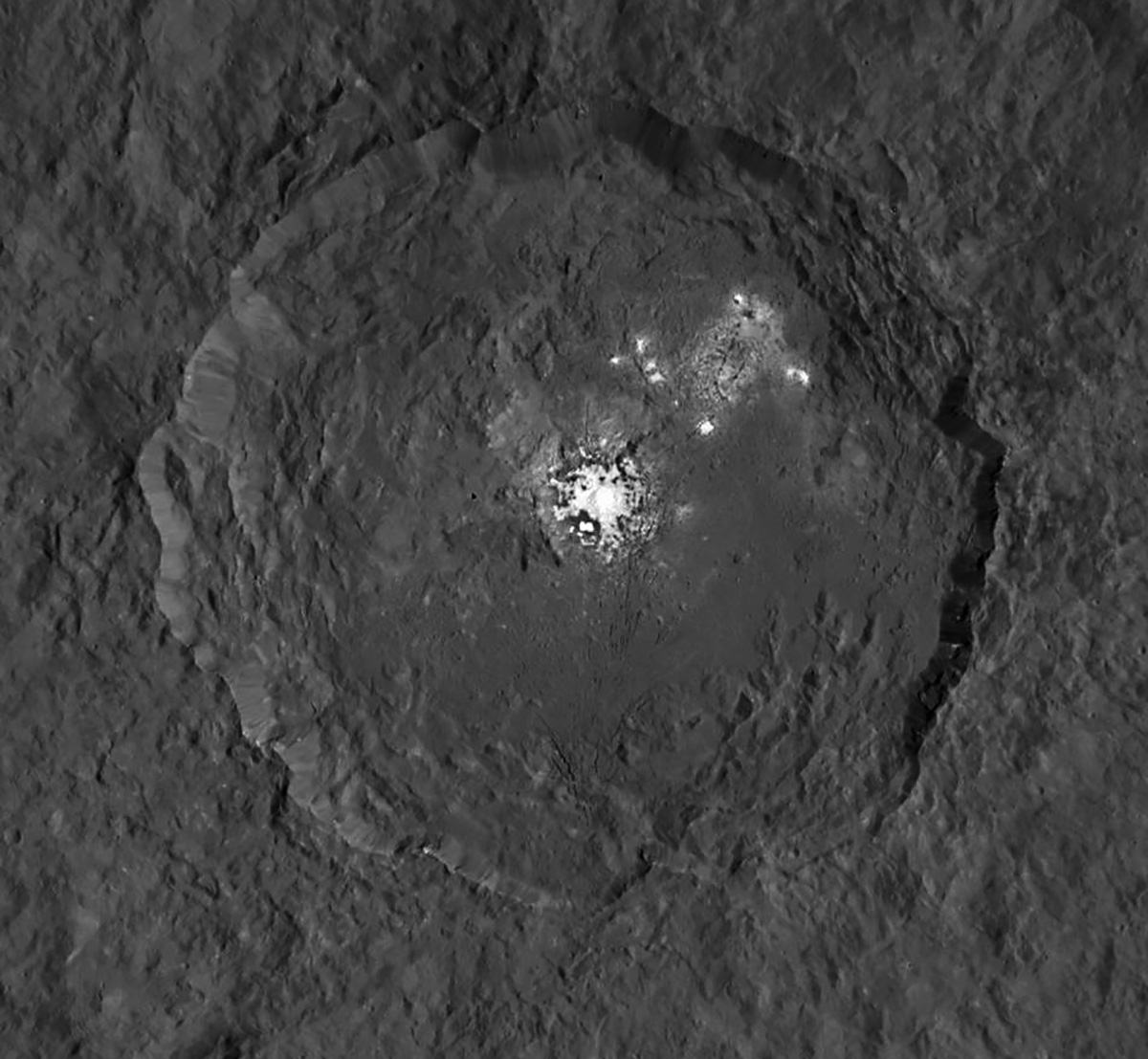
Dawn has also been busy imaging Oxo Crater, which despite its small size of merely 6-mile-wide (10-kilometer-wide) actually counts as a “hidden treasure” on Ceres – because it’s the second-brightest feature on Ceres!
Only the mysterious bright region comprising a multitude of spots inside Occator Crater shine more brightly on Ceres.
Most importantly, Oxo Crater is the only place on Ceres where Dawn has detected water at the surface so far. Via VIR, Dawn data indicate that the water exists either in the form of ice or hydrated minerals. Scientists speculate that the water was exposed either during a landslide or an impact.
“Little Oxo may be poised to make a big contribution to understanding the upper crust of Ceres,” said Chris Russell, principal investigator of the mission, based at the University of California, Los Angeles.
The signatures of minerals detected on the floor of Oxo crater appears to be different from the rest of Ceres.
Furthermore Oxo is “also unique because of the relatively large “slump” in its crater rim, where a mass of material has dropped below the surface.”
Oxo Crater on Ceres is unique because of the relatively large “slump” in its crater rim. The 6-mile-wide (10-kilometer-wide) Oxo crater is the second-brightest feature on Ceres. Credits: NASA/JPL-Caltech/UCLA/MPS/DLR/IDA/PSI
Dawn is Earth’s first probe in human history to explore any dwarf planet, the first to explore Ceres up close and the first to orbit two celestial bodies.
The asteroid Vesta was Dawn’s first orbital target where it conducted extensive observations of the bizarre world for over a year in 2011 and 2012.
The mission is expected to last until at least later into 2016, and possibly longer, depending upon fuel reserves.
Dawn will remain at its current altitude at LAMO for the rest of its mission, and indefinitely afterward, even when no further communications are possible.
Stay tuned here for Ken’s continuing Earth and planetary science and human spaceflight news.
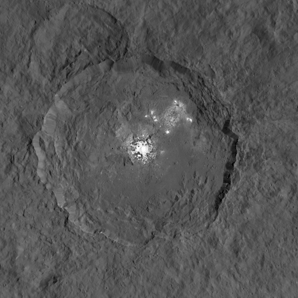
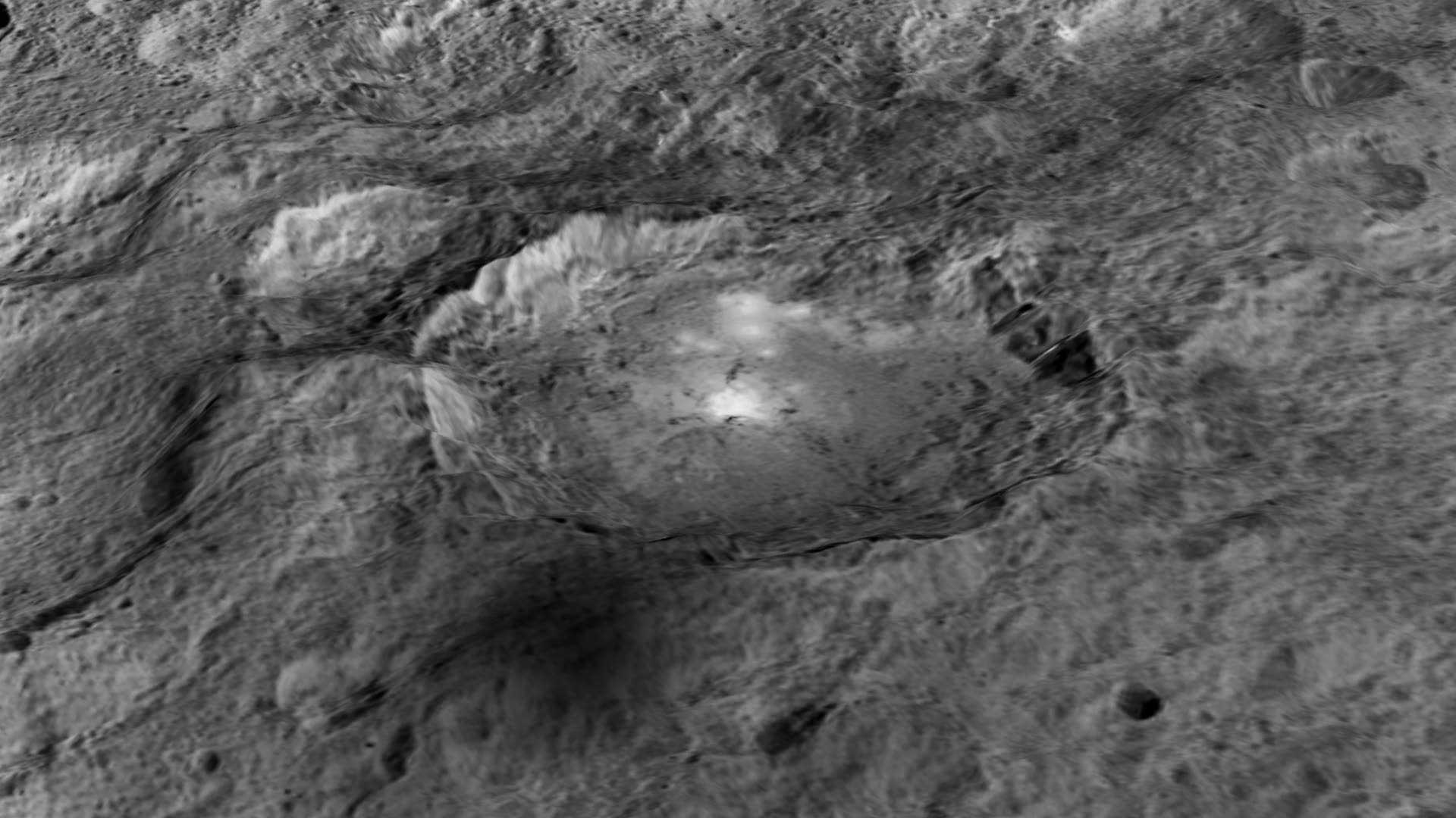
The bright central spots near the center of Occator Crater are shown in enhanced color in this view from NASA’s Dawn spacecraft. The view was produced by combining the highest resolution images taken in February 2016 at an image scale of 115 feet (35 meters) per pixel with color images obtained in September 2015 at a lower resolution added. Click for a highest-res view. Credit: NASA/JPL-Caltech/UCLA/MPS/DLR/IDA/PSI
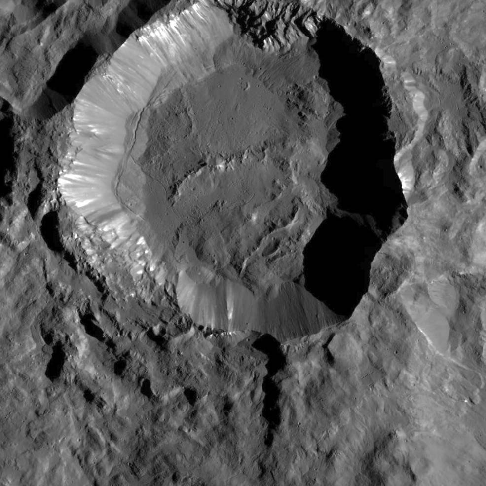
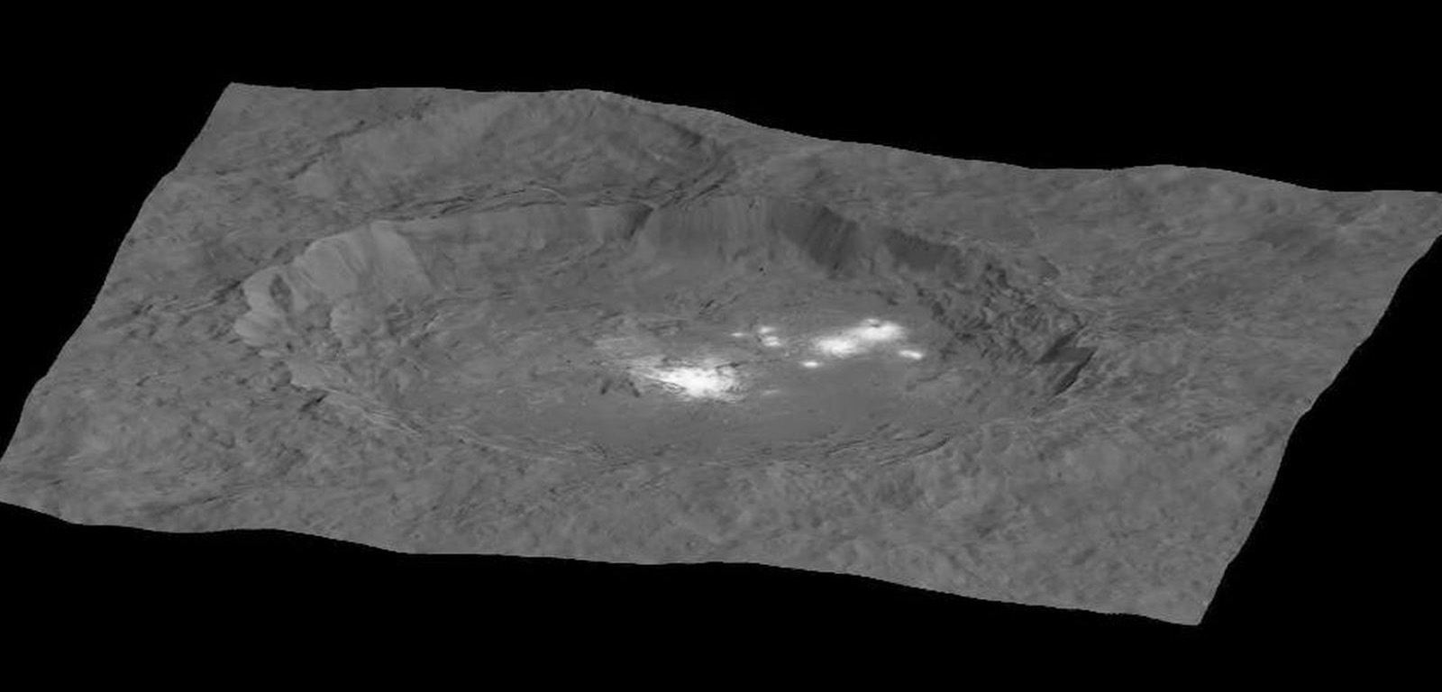
Ah, dome sweet dome. Scientists from NASA’s Dawn mission unveiled new images from the spacecraft’s lowest orbit at Ceres, including highly anticipated views of Occator Crater, at the 47th annual Lunar and Planetary Science Conference in The Woodlands, Texas, on Tuesday. The new images, taken from Dawn’s low-altitude mapping orbit (LAMO) of 240 miles (385 kilometers) above Ceres, reveal a dome in a smooth-walled pit in the bright center of the crater. Linear fractures crisscross the top and flanks of the dome with still more fractures slicing across the nearby plains.
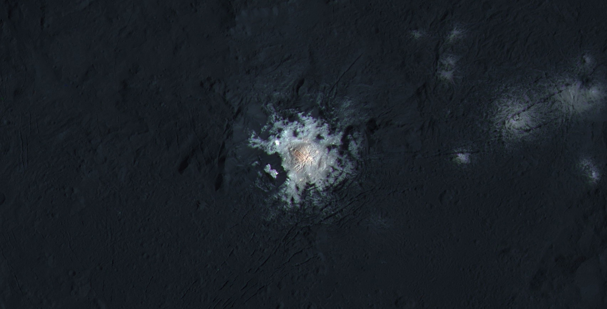
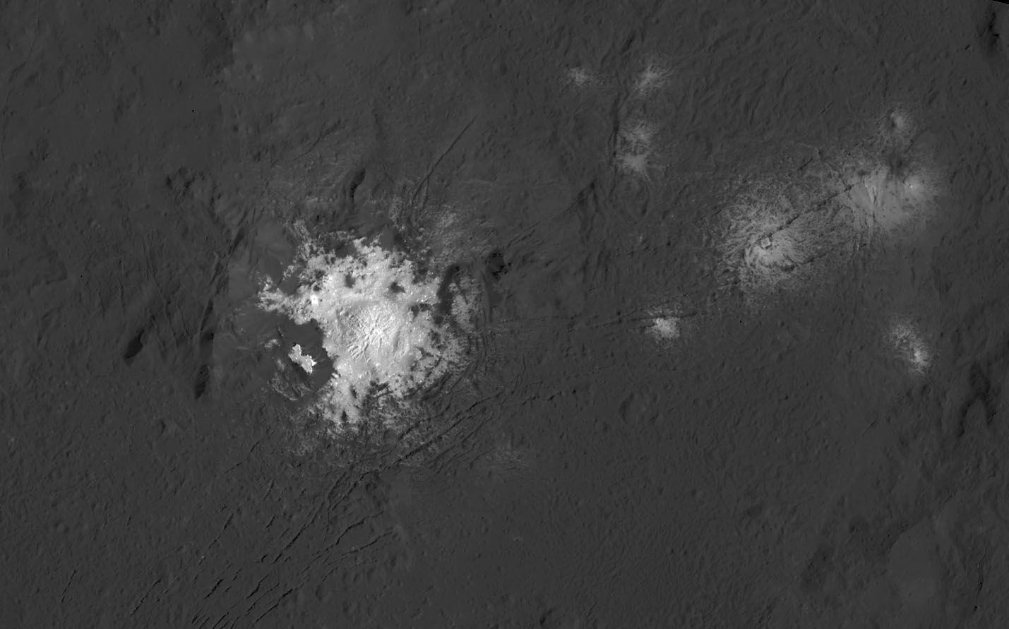
Occator Crater, measuring 57 miles (92 kilometers) across and 2.5 miles (4 kilometers) deep, contains the brightest area on Ceres. This photo has been exposed to show detail in the crater and landscape, so the bright spots are overexposed. The closeup photos on the other hand are correctly exposed to show detail in the spots but necessarily underexpose the landscape and make it look very dark. Credit: NASA/JPL-Caltech/UCLA/MPS/DLR/IDA/PSI
“Before Dawn began its intensive observations of Ceres last year, Occator Crater looked to be one large bright area. Now, with the latest close views, we can see complex features that provide new mysteries to investigate,” said Ralf Jaumann, planetary scientist and Dawn co-investigator at the German Aerospace Center (DLR) in Berlin. “The intricate geometry of the crater interior suggests geologic activity in the recent past, but we will need to complete detailed geologic mapping of the crater in order to test hypotheses for its formation.”
Black and white view of the bright spots in Occator Crater. Credit: NASA/JPL-Caltech/UCLA/MPS/DLR/IDA/PSI
Like me, you’ve probably been anticipating LAMO for months, when we’d finally get our clearest view of the famous “bright spots”. Spectral observations have shown that the patches are consistent with a magnesium sulfate called hexahydrite that resembles the more familiar Epsom salts here on Earth. Scientists think these salt-rich areas were residue left behind when water-ice sublimated in the past. Impacts from asteroids could have broken into Ceres’ crust and possibly unearthed salt-rich ices. Exposed to the vacuum of space, the ice would have sublimated (vaporized), leaving the salt behind.
This global map shows the surface of Ceres in enhanced color, including infrared wavelengths beyond human visual range. Photos were taken using infrared, green and blue filters and combined to create this view. Credit: NASA/JPL-Caltech/UCLA/MPS/DLR/IDA/PSI
The team also released an enhanced color map of the surface of Ceres that reveals a diversity of surface materials and how they relate to Ceres’ landforms. The dwarf planet doesn’t have as many large impact basins as scientists expected, but the number of smaller craters generally matches their predictions. The blue material highlighted in the color map is related to flows, smooth plains and mountains, which appear to be very young surface features.
“Although impact processes dominate the surface geology on Ceres, we have identified specific color variations on the surface indicating material alterations that are due to a complex interaction of the impact process and the subsurface composition,” Jaumann said. “Additionally, this gives evidence for a subsurface layer enriched in ice and volatiles.”
This map shows part of Ceres’ northern hemisphere with neutron counting data from Dawn’s gamma ray and neutron detector (GRaND) instrument and reflect the concentration of hydrogen in the upper yard (or meter) of regolith, the loose surface material on Ceres. Colors are based on the number of neutrons detected per second by GRaND. Counts decrease with increasing hydrogen concentration. The color scale of the map is from blue (lowest neutron count) to red (highest neutron count). Lower neutron counts near the pole suggest the presence of water ice within about a yard (meter) of the surface at high latitudes. Credit: NASA/JPL-Caltech/UCLA/MPS/DLR/IDA/PSI
We’re learning more about that subsurface ice thanks to Dawn’s Gamma Ray and Neutron Detector (GRaND). Neutrons and gamma rays produced by cosmic rays interacting with the topmost yard (meter) of the loose rock and dust called regolith provide a fingerprint of Ceres’ chemical makeup. Lower counts indicate the presence of hydrogen, and since water’s rich in hydrogen (H2o), the results from GRanD suggest concentrations of water ice in the near-surface at high latitudes.
“Our analyses will test a longstanding prediction that water ice can survive just beneath Ceres’ cold, high-latitude surface for billions of years,” said Tom Prettyman, the lead for GRaND and Dawn co-investigator at the Planetary Science Institute, Tucson, Arizona.
Ceres’ Oxo Crater (right) is the only place on the dwarf planet where water has been detected on the surface so far. Credit: NASA/JPL-Caltech/UCLA/MPS/DLR/IDA/PSI
Dawn scientists also reported that the Visual and Infrared Mapping Spectrometer (VIR) has detected water at Oxo Crater, a young, 6-mile-wide (9-kilometer-wide) feature in Ceres’ northern hemisphere. This water could either be bound up in minerals or exist as ice and may have been exposed during a landslide or impact or a combination of the two events. Oxo is the only place on Ceres where water has been detected at the surface so far.
Ceres’ Haulani Crater (21 miles, 34 kilometers wide) is shown in these views made with VIR. They reveal variations in the region’s brightness, mineralogy and temperature at infrared wavelengths in the types of rock and ejected material around the crater. Scientists see this as evidence that the material in this area is not uniform, and that the crater’s interior has a different composition than its surroundings. Credit: NASA/JPL-Caltech/UCLA/MPS/DLR/IDA/PSI
Not only have scientists found evidence of possible extensive subsurface ice, but the composition of the surface is variable. Using VIR, which measures mineral composition by how those minerals reflect sunlight, they found that Haulani Crater shows a different proportion of surface materials than its surroundings. While the surface of Ceres is mostly made of a mixture of materials containing carbonates and phyllosilicates (clays), their relative proportion varies across the surface.
“False-color images of Haulani show that material excavated by an impact is different than the general surface composition of Ceres. The diversity of materials implies either that there is a mixed layer underneath, or that the impact itself changed the properties of the materials,” said Maria Cristina de Sanctis, the VIR instrument lead scientist.
All these cool stuff we’re finding out about this small body makes it nearly as exciting as Pluto. Taking a closer look is the best form of education.
Bright reflective material in Ceres' Occator crater, imaged by NASA's Dawn spacecraft in Sept .2015. Credit: NASA/JPL-Caltech/UCLA/MPS/DLR/IDA.
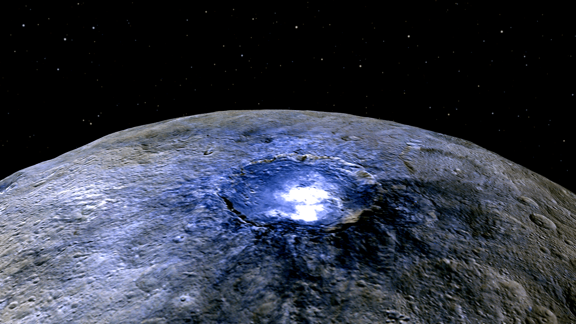
All right, maybe not blinking like a flashlight (or a beacon on the tippity-top of a communication tower—don’t even start that speculation up) but the now-famous “bright spots” on the dwarf planet Ceres have been observed to detectably increase and decrease in brightness, if ever-so-slightly.
And what’s particularly interesting is that these observations were made not by NASA’s Dawn spacecraft, currently in orbit around Ceres, but from a telescope right here on Earth.
Researchers using the High Accuracy Radial velocity Planet Searcher (HARPS) instrument on ESO’s 3.6-meter telescope at La Silla detected “unexpected” changes in the brightness of Ceres during observations in July and August of 2015. Variations in line with Ceres’ 9-hour rotational period—specifically a Doppler effect in spectral wavelength created by the motion of the bright spots toward or away from Earth—were expected, but other fluctuations in brightness were also detected.
“The result was a surprise,” said Antonino Lanza from the INAF–Catania Astrophysical Observatory, co-author of the study. “We did find the expected changes to the spectrum from the rotation of Ceres, but with considerable other variations from night to night.”
Watch a video below illustrating the rotation of Ceres and how reflected light from the bright spots within Occator crater are alternately blue- and red-shifted according to the motion relative to Earth.
First observed with Hubble in December 2003, Ceres’ curious bright spots were resolved by Dawn’s cameras to be a cluster of separate regions clustered inside the 60-mile (90-km) -wide Occator crater. Based on Dawn data they are composed of some type of highly-reflective materials like salt and ice, although the exact composition or method of formation isn’t yet known.
Since they are made of such volatile materials though, interaction with solar radiation is likely the cause of the observed daily brightening. As the deposits heat up during the course of the 4.5-hour Ceres daytime they may create hazes and plumes of reflective particles.
“It has been noted that the spots appear bright at dawn on Ceres while they seem to fade by dusk,” noted study lead author Paolo Molaro in the team’s paper. “That could mean that sunlight plays an important role, for instance by heating up ice just beneath the surface and causing it to blast off some kind of plume or other feature.”
Once day turns to night these hazes will re-freeze, depositing the particles back down to the surface—although never in exactly the same way. These slight differences in evaporation and condensation could explain the random variation in daily brightening observed with HARPS.
These findings have been published the journal Monthly Notices of the Royal Astronomical Society (full text on arXiv here.)
New Animation Takes a Colorful Flight Over Ceres
Simulated view of Dwarf planet Ceres using images from NASA's Dawn spacecraft. Image Credit: NASA/JPL-Caltech/UCLA/MPS/DLR/IDA.
Wow. This video will knock your socks off … at least it did mine. This new flyover video of Ceres was created using enhanced images taken by the Dawn spacecraft’s framing camera. It was produced by the camera team at the German Aerospace Center, DLR, using images from Dawn’s high-altitude mapping orbit of 900 miles (1,450 kilometers) above Ceres’ surface. The video shows a stark and stunning world.
“The viewer can observe the sheer walls of the crater Occator, and also Dantu and Yalode, where the craters are a lot flatter,” said Ralf Jaumann, a Dawn mission scientist at DLR.
The enhanced color used here helps to highlight subtle differences in the appearance of surface materials. There’s additional info at the end of the video, but for a quick reference, area with shades of blue contain younger, fresher material such as flows, pits and cracks, while brown areas clays, which, enticingly, usually form in the presence of water.
I had the chance to visit with Marc Rayman, Dawn’s chief engineer and mission director at JPL earlier this month, when I interviewed him for a book I’m working on about robotic space exploration. One thing he really stressed is that Ceres is a big place, with diverse terrain and a variety of features. This video really brings that home.
“Ceres has a surface area of 2,770,000 square kilometers … It’s a big surface and we haven’t seen all of it,” Rayman said. “It will be great to see what the new detail shows from the low altitude orbit, because those pictures will be four times better resolution than pictures we were able to get at our previous orbit.”
Dawn is now in its final and lowest mapping orbit, at about 240 miles (385 kilometers) from the surface.
This animated flight over Ceres emphasizes the most prominent craters, such as Occator, Dantu, and the tall, conical mountain Ahuna Mons.
The bright features seen in Occator Crater have been determined to be salts, which are quite reflective and look bright to our eyes (sorry no alien city lights) and the team will be providing more details and images soon.
Occator Crater (57 miles, 92 kilometers) on Ceres, home of the brightest spots on the dwarf planet, in a simulated view using Dawn images. Image Credit: NASA/JPL-Caltech/UCLA/MPS/DLR/IDA.
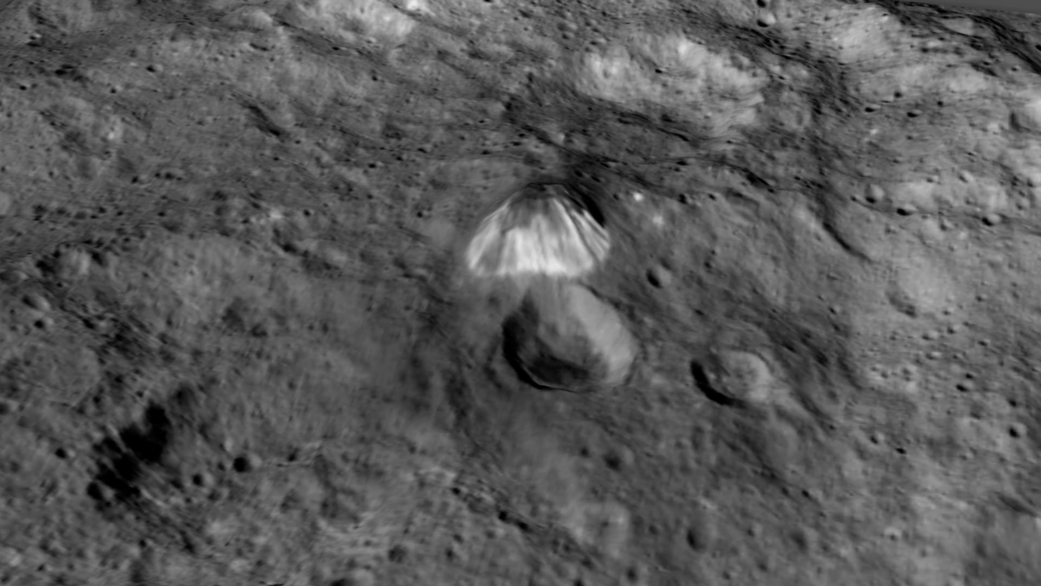
This image from NASA's Dawn spacecraft shows Kupalo Crater, one of the youngest craters on Ceres. The crater has bright material exposed on its rim and walls, which could be salts. Its flat floor likely formed from impact melt and debris. Credits: NASA/JPL-Caltech/UCLA/MPS/DLR/IDA
This image from NASA’s Dawn spacecraft shows Kupalo Crater, one of the youngest craters on Ceres. The crater has bright material exposed on its rim and walls, which could be salts. Its flat floor likely formed from impact melt and debris. Credits: NASA/JPL-Caltech/UCLA/MPS/DLR/IDA
NASA’s Dawn spacecraft has unveiled a new patch of intriguing bright features in the most recent series of striking close-up images taken just after the probe reached the lowest altitude it will ever reach during the mission.
From Dawn’s current altitude of 240 miles (385 kilometers) above Ceres, every image taken from now on of the “unique landforms” will be of the highest resolution attainable since the ship will never swoop down closer to the pockmarked surface for science. Continue reading “Dawn Unveils New Bright Features on Ceres in Striking Close-Ups”
This representation of Ceres' Occator Crater in false colors shows differences in the surface composition. Red corresponds to a wavelength range around 0.97 micrometers (near infrared), green to a wavelength range around 0.75 micrometers (red, visible light) and blue to a wavelength range of around 0.44 micrometers (blue, visible light). Occator measures about 60 miles (90 kilometers) wide. Credits: NASA/JPL-Caltech/UCLA/MPS/DLR/IDA
This representation of Ceres’ Occator Crater in false colors shows differences in the surface composition. Red corresponds to a wavelength range around 0.97 micrometers (near infrared), green to a wavelength range around 0.75 micrometers (red, visible light) and blue to a wavelength range of around 0.44 micrometers (blue, visible light). Occator measures about 60 miles (90 kilometers) wide. Credits: NASA/JPL-Caltech/UCLA/MPS/DLR/IDA
With NASA’s Dawn spacecraft set to enter its final and lowest orbit around the dwarf planet Ceres, spectral measurements are enabling researchers to gradually unravel the nature of the numerous mysterious and intriguing bright spots recently discovered, and now they conclude that briny mixtures of ice and salts apparently reside just beneath certain patches of the pockmarked surface and that “water is sublimating” from the surface of an “active crater”.
This mosaic shows Ceres' Occator crater and surrounding terrain from an altitude of 915 miles (1,470 kilometers), as seen by NASA's Dawn spacecraft. Occator is about 60 miles (90 kilometers) across and 2 miles (4 kilometers) deep. Credits: NASA/JPL-Caltech/UCLA/MPS/DLR/IDA
The most dazzling views ever seen of dwarf planet Ceres and its mysterious bright spots are what’s on tap by year’s end as NASA’s amazing Dawn spacecraft starts a gradual but steep descent over the next two months to its lowest and final orbit around the bizarre icy body.
Engineers at NASA’s Jet Propulsion Laboratory (JPL) successfully fired up the probes exotic ion propulsion system to begin lowering Dawn’s orbital altitude to less than a quarter of what it has been for the past two months of intense mapping operations.
On Oct. 23, Dawn began a seven-week-long dive that uses ion thruster #2 to reduce the spacecrafts vantage point from 915 miles (1,470 kilometers) at the High Altitude Mapping Orbit (HAMO) down to less than 235 miles (380 kilometers) above Ceres at the Low Altitude Mapping Orbit (LAMO).
Dawn is slated to arrive at LAMO by mid-December, just in time to begin delivering the long awaiting Christmas treats.
Ceres has absolutely tantalized researchers far beyond their wildest expectations.
When Dawn arrives at LAMO it will be the culmination of an eight year interplanetary voyage that began with a blastoff on September 27, 2007 by a United Launch Alliance (ULA) Delta II Heavy rocket from Space Launch Complex-17B (SLC-17B) at Cape Canaveral Air Force Station, Florida.
LAMO marks Dawn’s fourth, lowest and final science orbit at Ceres where the highest resolution observations will be gathered and images from the framing camera will achieve a resolution of 120 feet (35 meters) per pixel.
Dawn’s low altitude mapping orbit LAMO. This shows how the orbit naturally shifts slightly (relative to the sun) during the three months of LAMO, starting in blue and ending in red. The spacecraft completes each revolution in 5.5 hours, and Ceres rotates in 9.1 hours, so Dawn will be able to view the entire surface. Credit: NASA/JPL
At LAMO, researchers hope to finally resolve the enduring mystery of the nature of the bright spots that have intrigued science and the general public since they were first glimpsed clearly early this year as Dawn was on its final approach to Ceres.
Dawn arrived in orbit this past spring on March 6, 2015.
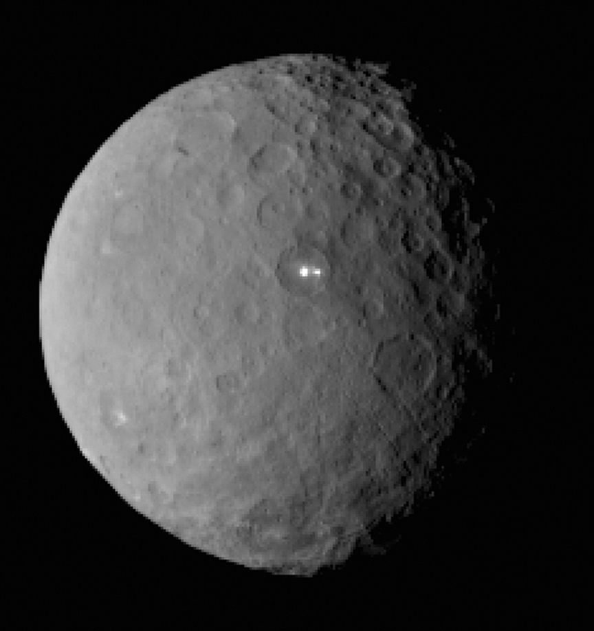
This image was taken by NASA’s Dawn spacecraft of dwarf planet Ceres on Feb. 19 from a distance of nearly 29,000 miles (46,000 km). It shows that the brightest spot on Ceres has a dimmer companion, which apparently lies in the same basin. See below for the wide view. Credit: NASA/JPL-Caltech/UCLA/MPS/DLR/IDA
The science team has just released a new mosaic of the brightest spots on Ceres found at Occator crater and the surrounding terrain – see above.
The images were taken from the HAMO altitude of 915 miles (1,470 kilometers) during the first of six mapping cycles. They have a resolution of 450 feet (140 meters) per pixel.
Occator measures about 60 miles (90 kilometers) across and 2 miles (4 kilometers) deep.
This image, made using images taken by NASA’s Dawn spacecraft during the mission’s High Altitude Mapping Orbit (HAMO) phase, shows Occator crater on Ceres, home to a collection of intriguing bright spots. Credits: NASA/JPL-Caltech/UCLA/MPS/DLR/IDA
Because the spots are so bright they are generally overexposed. Therefore the team took two sets of images, with shorter and longer exposure times, to maximize the details of the interior of Occator.
“This view uses a composite of two images of Occator: one using a short exposure that captures the detail in the bright spots, and one where the background surface is captured at normal exposure.”
The bright spots at Occator crater remain the biggest Cerean mystery.
So far the imagery and other science data may point to evaporation of salty water from the interior as the source of the bright spots.
“Occasional water leakage on to the surface could leave salt there as the water would sublime,” Prof. Chris Russell, Dawn principal investigator told Universe Today exclusively.
“The big picture that is emerging is that Ceres fills a unique niche.”
“Ceres fills a unique niche between the cold icy bodies of the outer solar system, with their rock hard icy surfaces, and the water planets Mars and Earth that can support ice and water on their surfaces,” Russell, of the University of California, Los Angeles, told me.
Dawn has peeled back Ceres secrets as the spacecraft orbits lower and lower. Detailed measurements gathered to date have yielded global mineral and topographic maps from HAMO with the best resolution ever as the science team painstakingly stitched together the probes spectral and imaging products.
And the best is yet to come at LAMO.
At HAMO, Dawn’ instruments, including the Framing Camera and Visible and Infrared Spectrometer (VIR) were aimed at slightly different angles in each mapping cycle allowing the team to generate stereo views and construct 3-D maps.
“The emphasis during HAMO is to get good stereo data on the elevations of the surface topography and to get good high resolution clear and color data with the framing camera,” Russell explained.
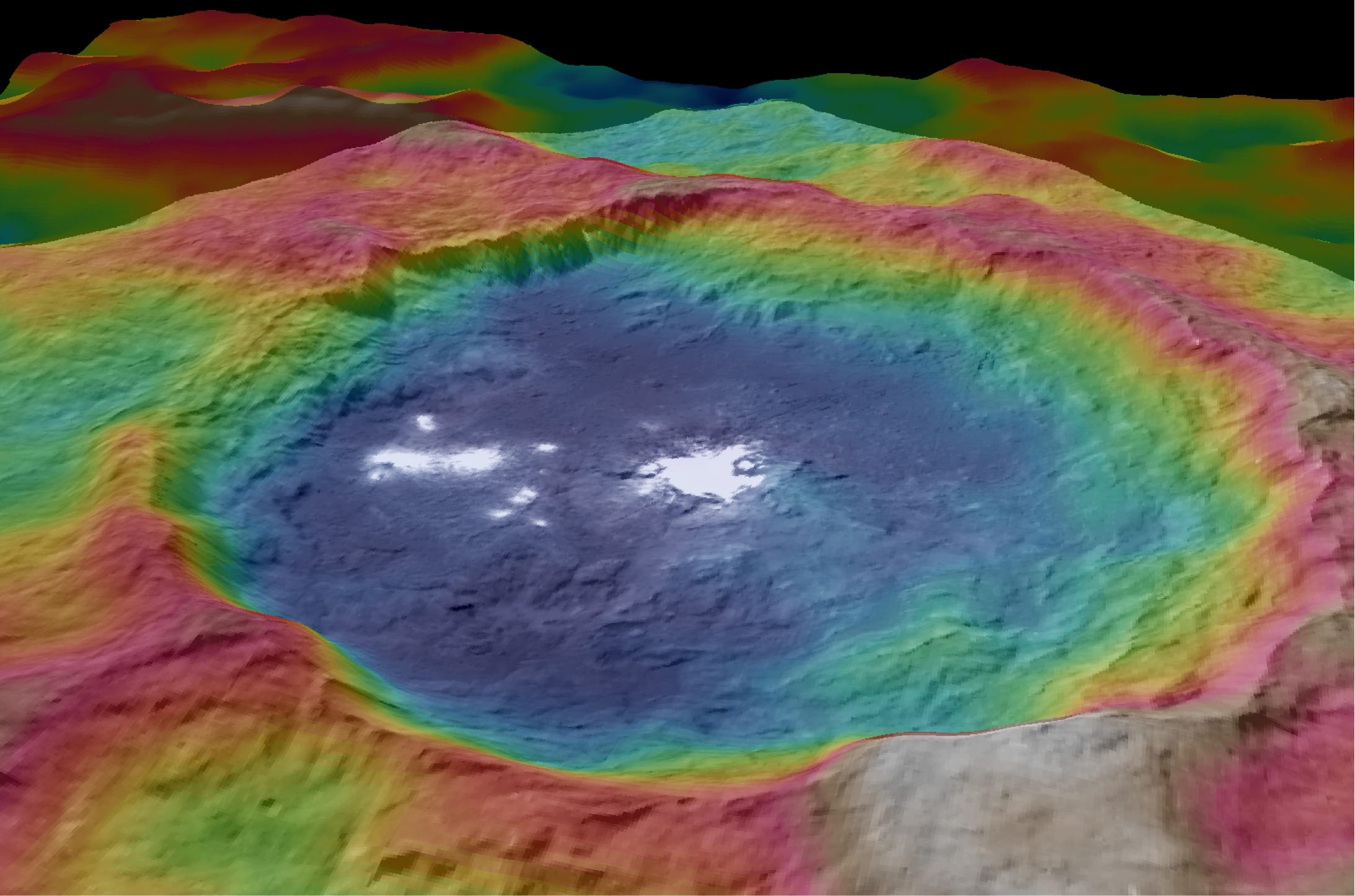
This view from NASA’s Dawn spacecraft is a color-coded topographic map of Occator crater on Ceres. Blue is the lowest elevation, and brown is the highest. The crater, which is home to the brightest spots on Ceres, is approximately 56 miles (90 kilometers wide). Credits: NASA/JPL-Caltech/UCLA/MPS/DLR/IDA
Dawn is Earth’s first probe in human history to explore any dwarf planet, the first to explore Ceres up close and the first to orbit two celestial bodies.
The asteroid Vesta was Dawn’s first orbital target where it conducted extensive observations of the bizarre world for over a year in 2011 and 2012.
Ceres is a Texas-sized world, ranks as the largest object in the main asteroid belt between Mars and Jupiter, and may have a subsurface ocean of liquid water that could be hospitable to life.
This map-projected view of Ceres was created from images taken by NASA’s Dawn spacecraft during its high-altitude mapping orbit, in August and September, 2015. This color coded map can provide valuable insights into the mineral composition of the surface, as well as the relative ages of surface features. Credits: NASA/JPL-Caltech/UCLA/MPS/DLR/IDA
The mission is expected to last until at least March 2016, and possibly longer, depending upon fuel reserves.
“It will end some time between March and December,” Dr. Marc Rayman, Dawn’s chief engineer and mission director based at NASA’s Jet Propulsion Laboratory, Pasadena, California, told Universe Today.
Stay tuned here for Ken’s continuing Earth and planetary science and human spaceflight news.
An artist’s conception shows NASA’s Dawn spacecraft flying above Ceres. This view incorporates actual imagery from the Dawn mission. Credit: NASA/JPL-Caltech/UCLA/MPS/DLR/IDA
This map-projected view of Ceres was created from images taken by NASA's Dawn spacecraft during its high-altitude mapping orbit, in August and September, 2015. This color coded map can provide valuable insights into the mineral composition of the surface, as well as the relative ages of surface features. Credits: NASA/JPL-Caltech/UCLA/MPS/DLR/IDA
Slowly but surely the mysteries of dwarf planet Ceres are being peeled back layer by layer as NASA’s Dawn spacecraft orbits lower and lower and gathers detailed measurements that have now yielded global mineral and topographic maps, tantalizing researchers with the best resolution ever.
The Dawn science team has been painstakingly stitching together the spectral and imaging products captured from the lowest orbit yet achieved into high resolution global maps of Ceres, released today Sept. 30, by NASA.
“Ceres continues to amaze, yet puzzle us, as we examine our multitude of images, spectra and now energetic particle bursts,” said Chris Russell, Dawn principal investigator at the University of California, Los Angeles, in a statement.
The color coded map above is providing researchers with valuable insights into the mineral composition of Ceres surface, as well as the relative ages of the surface features that were a near total mystery until Dawn arrived on March 6, 2015.
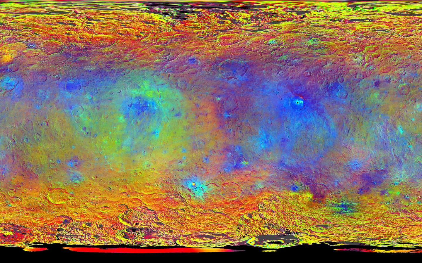
The false-color mineral map view combines images taken using infrared (920 nanometers), red (750 nanometers) and blue (440 nanometers) spectral filters.
“Redder colors indicate places on Ceres’ surface that reflect light strongly in the infrared, while bluish colors indicate enhanced reflectivity at short (bluer) wavelengths; green indicates places where albedo, or overall brightness, is strongly enhanced,” say officials.
“Scientists use this technique in order to highlight subtle color differences across Ceres, which would appear fairly uniform in natural color. This can provide valuable insights into the mineral composition of the surface, as well as the relative ages of surface features.”
Researchers say the mineral variations at Ceres “are more subtle than on Vesta, Dawn’s previous port of call.”
The asteroid Vesta was Dawn’s first orbital target and conducted extensive observations of the bizarre world for over a year in 2011 and 2012.
The Dawn team is meeting this week to review and publish the mission results so far at the European Planetary Science Conference in Nantes, France.
Dawn is Earth’s first probe in human history to explore any dwarf planet, the first to explore Ceres up close and the first to orbit two celestial bodies.
Ceres is a Texas-sized world, ranks as the largest object in the main asteroid belt between Mars and Jupiter, and may have a subsurface ocean of liquid water that could be hospitable to life.
This view from NASA’s Dawn spacecraft is a color-coded topographic map of Occator crater on Ceres. Blue is the lowest elevation, and brown is the highest. The crater, which is home to the brightest spots on Ceres, is approximately 56 miles (90 kilometers wide). Credits: NASA/JPL-Caltech/UCLA/MPS/DLR/IDA
The newly released maps were created from data gathered at Dawn’s current science orbit, known as the High Altitude Mapping Orbit (HAMO) phase of the mission, during August and September.
At HAMO, Dawn is circling Ceres at an altitude of barely 915 miles (1,470 kilometers) above the heavily cratered surface.
“Dawn arrived in this third mapping orbit [HAMO] on Aug. 13. It began this third mapping phase on schedule on Aug. 17,” Dr. Marc Rayman, Dawn’s chief engineer and mission director based at NASA’s Jet Propulsion Laboratory, Pasadena, California, told Universe Today.
Each HAMO mapping orbit cycle lasts 11 days and consists of 14 orbits lasting 19 hours each. Ceres is entirely mapped during each of the 6 cycles. The third mapping cycle started on Sept. 9.
Dawn’ instruments, including the Framing Camera and Visible and Infrared Spectrometer (VIR) will be aimed at slightly different angles in each mapping cycle allowing the team to generate stereo views and construct 3-D maps.
“The emphasis during HAMO is to get good stereo data on the elevations of the surface topography and to get good high resolution clear and color data with the framing camera,” Russell told me.
“We are hoping to get lots of VIR IR data to help understand the composition of the surface better.”
“Dawn will use the color filters in its framing camera to record the sights in visible and infrared wavelengths,” notes Rayman.
The new maps at HAMO provide about three times better resolution than the images captured from its previous orbit in June, and nearly 10 times better than in the spacecraft’s initial orbit at Ceres in April and May.
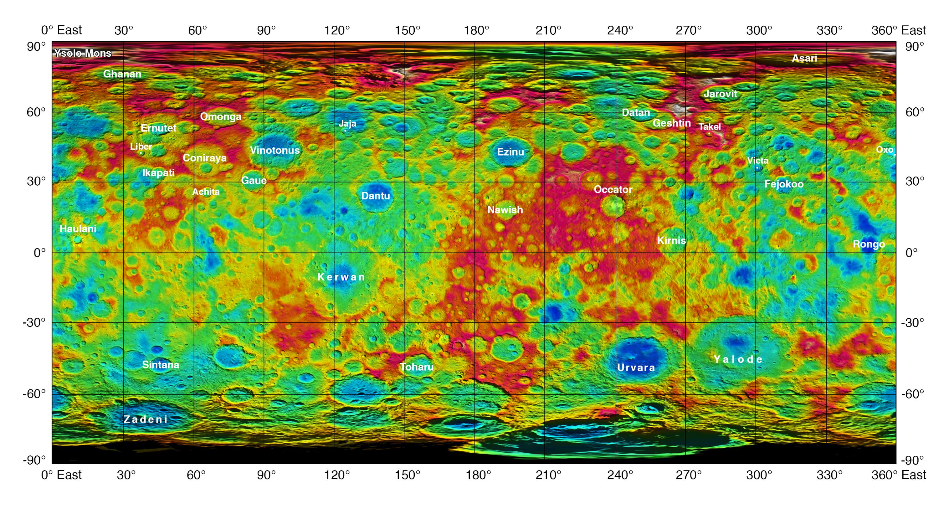
This color-coded map from NASA’s Dawn shows the highs and lows of topography on the surface of dwarf planet Ceres. It is labeled with names of features approved by the International Astronomical Union. The color scale extends about 5 miles (7.5 kilometers) below the reference surface in indigo to 5 miles (7.5 kilometers) above the reference surface in white. Credits: NASA/JPL-Caltech/UCLA/MPS/DLR/IDA
The science team also released a new color-coded topographic map annotated with over a dozen Cerean feature names recently approved by the IAU.
“The names for features on Ceres are all eponymous for agricultural spirits, deities and festivals from cultures around the world. These include Jaja, after the Abkhazian harvest goddess, and Ernutet, after the cobra-headed Egyptian harvest goddess. A 12-mile (20-kilometer) diameter mountain near Ceres’ north pole is now called Ysolo Mons, for an Albanian festival that marks the first day of the eggplant harvest.”
The biggest Cerean mystery of all remains the nature of the bright spots at Occator crater. It’s still under analysis and the team released a new color coded topographic map.
The imagery and other science data may point to evaporation of salty water as the source of the bright spots.
“Occasional water leakage on to the surface could leave salt there as the water would sublime,” Russell told me.
“The big picture that is emerging is that Ceres fills a unique niche,” Prof. Chris Russell, Dawn principal investigator told Universe Today exclusively.
“Ceres fills a unique niche between the cold icy bodies of the outer solar system, with their rock hard icy surfaces, and the water planets Mars and Earth that can support ice and water on their surfaces,” said Russell.
“The irregular shapes of craters on Ceres are especially interesting, resembling craters we see on Saturn’s icy moon Rhea,” says Carol Raymond, Dawn’s deputy principal investigator based at NASA’s Jet Propulsion Laboratory, Pasadena, California. “They are very different from the bowl-shaped craters on Vesta.”
This image was taken by NASA’s Dawn spacecraft of dwarf planet Ceres on Feb. 19 from a distance of nearly 29,000 miles (46,000 km). It shows that the brightest spot on Ceres has a dimmer companion, which apparently lies in the same basin. See below for the wide view. Credit: NASA/JPL-Caltech/UCLA/MPS/DLR/IDA
Dawn was launched on September 27, 2007 by a United Launch Alliance (ULA) Delta II Heavy rocket from Space Launch Complex-17B (SLC-17B) at Cape Canaveral Air Force Station, Florida.
Stay tuned here for Ken’s continuing Earth and planetary science and human spaceflight news.
This image, made using images taken by NASA’s Dawn spacecraft during the mission’s High Altitude Mapping Orbit (HAMO) phase, shows Occator crater on Ceres, home to a collection of intriguing bright spots. Credits: NASA/JPL-Caltech/UCLA/MPS/DLR/IDA
This image, made using images taken by NASA's Dawn spacecraft during the mission's High Altitude Mapping Orbit (HAMO) phase, shows Occator crater on Ceres, home to a collection of intriguing bright spots. Credits: NASA/JPL-Caltech/UCLA/MPS/DLR/IDA
This image, made using images taken by NASA’s Dawn spacecraft during the mission’s High Altitude Mapping Orbit (HAMO) phase, shows Occator crater on Ceres, home to a collection of intriguing bright spots. Credits: NASA/JPL-Caltech/UCLA/MPS/DLR/IDA
Story/imagery updated[/caption]
Since scientists believe that Ceres occupies a “unique niche” in the solar system and apparently harbors subsurface ice or liquid oceans, could the bright spots arise from subsurface “water leakage?” To find out Universe Today asked Dawn’s Principal Investigator and Chief Engineer.
“The big picture that is emerging is that Ceres fills a unique niche,” Prof. Chris Russell, Dawn principal investigator told Universe Today exclusively.
“Ceres fills a unique niche between the cold icy bodies of the outer solar system, with their rock hard icy surfaces, and the water planets Mars and Earth that can support ice and water on their surfaces,” said Russell, of the University of California, Los Angeles.
And with Dawn recently arrived at its second lowest science mapping orbit of the planned mission around icy dwarf planet Ceres in mid-August, the NASA spacecraft is capturing the most stunningly detailed images yet of those ever intriguing bright spots located inside Occator crater.
The imagery and other science data may point to evaporation of salty water as the source of the bright spots.
“Occasional water leakage on to the surface could leave salt there as the water would sublime,” Russell told me.
Circling the Lights of Occator crater on Ceres. This image, made using images taken by NASA’s Dawn spacecraft during the mission’s High Altitude Mapping Orbit (HAMO) phase and draped over a shape model, shows Occator crater on Ceres, home to a collection of intriguing bright spots. The image has been stretched by 1.5 times in the vertical direction to better illustrate the crater’s topography. Credits: NASA/JPL-Caltech/UCLA/MPS/DLR/IDA
Dawn is Earth’s first probe to explore any dwarf planet and the first to explore Ceres up close. It was built by Orbital ATK.
To shed more light on what still remains rather mysterious even today, NASA has just released the best yet imagery, which was taken at Dawn’s High Altitude Mapping Orbit (HAMO) phase and they raise as many questions as they answer.
Occator has captured popular fascination world-wide because the 60 miles (90 kilometers) diameter crater is rife with the alien bodies brightest spots and whose nature remains elusive to this day, over half a year after Dawn arrived in orbit this past spring on March 6, 2015.
The new imagery from Dawn’s current HAMO mapping orbit was taken at an altitude of just 915 miles (1,470 kilometers). They provide about three times better resolution than the images captured from its previous orbit in June, and nearly 10 times better than in the spacecraft’s initial orbit at Ceres in April and May, says the team.
So with the new HAMO orbit images in hand, I asked the team what’s the latest thinking on the bright spots nature?
Initially a lot of speculation focused on water ice. But the scientists opinions have changed substantially as the data pours in from the lower orbits and forced new thinking on alternative hypotheses – to the absolute delight of the entire team!
“When the spots appeared at first to have an albedo approaching 100%, we were forced to think about the possibility of [water] ice being on the surface,” Russell explained.
“However the survey data revealed that the bright spots were only reflecting about 50% of the incoming light.”
“We did not like the ice hypothesis because ice sublimes under the conditions on Ceres surface. So we were quite relieved by the lower albedo.”
“So what could be 50% reflective? If we look at Earth we find that when water evaporates on the desert it leaves salt which is reflective. We know from its density that water or ice is inside Ceres.”
“So the occasional water leakage on to the surface could leave salt there as the water would sublime even faster than ice.”
At this time no one knows how deep the potential ice deposit or water reservoir sources of the “water leakage” reside beneath the surface, or whether the bright salt spots arose from past or current activity and perhaps get replenished or enlarged over time. To date there is no evidence showing plumes currently erupting from the Cerean surface.
Video Caption: Circling Occator Crater on Ceres. This animation, made using data from NASA’s Dawn spacecraft, shows the topography of Occator crater on Ceres. Credits: Credit: NASA/JPL-Caltech/UCLA/MPS/DLR/IDA/PSI
Dawn is an international science mission and equipped with a trio of state of the art science instruments from Germany, Italy and the US. They will elucidate the overall elemental and chemical composition and nature of Ceres, its bright spots and other wondrous geological features like the pyramidal mountain object.
I asked the PI and Chief Engineer to explain specifically how and which of the instruments is the team using right now at HAMO to determine the bright spots composition?
“The instruments that will reveal the composition of the spots are the framing camera [from Germany], the infrared spectrometer, and the visible spectrometer [both from the VIR instrument from Italy], replied Dr. Marc Rayman, Dawn’s chief engineer and mission director based at NASA’s Jet Propulsion Laboratory, Pasadena, California.
“Dawn arrived in this third mapping orbit [HAMO] on Aug. 13. It began this third mapping phase on schedule on Aug. 17.”
But much work remains to gather and interpret the data and discern the identity of which salts are actually present on Ceres.
“While salts of various sorts have the right reflectance, they are hard to distinguish from one another in the visible,” Russell elaborated to Universe Today.
“That is one reason VIR is working extra hard on the IR spectrum. Scientists are beginning to speculate on the salts. And to think about what salts could be formed in the interior.”
“That is at an early stage right now,” Russell stated.
“I know of nothing exactly like these spots anywhere. We are excited about these scientific surprises!”
Occator crater lies in Ceres northern hemisphere.
“There are other lines of investigation besides direct compositional measurement that will provide insight into the spots, including the geological context,” Rayman told Universe Today.
Each of Dawn’s two framing cameras is also outfitted with a wheel of 7 color filters, explained Joe Makowski, Dawn program manager from Orbital ATK, in an interview.
Different spectral data is gathered using the different filters which can be varied during each orbit.
“So far Dawn has completed 2 mapping orbit cycles of the 6 cycles planned at HAMO.”
Each HAMO mapping orbit cycle lasts 11 days and consists of 14 orbits lasting 19 hours each. Ceres is entirely mapped during each of the 6 cycles. The third mapping cycle just started on Wednesday, Sept. 9.
The instruments will be aimed at slightly different angle in each mapping cycle allowing the team to generate stereo views and construct 3-D maps.
“The emphasis during HAMO is to get good stereo data on the elevations of the surface topography and to get good high resolution clear and color data with the framing camera,” Russell explained.
“We are hoping to get lots of VIR IR data to help understand the composition of the surface better.”
“Dawn will use the color filters in its framing camera to record the sights in visible and infrared wavelengths,” notes Rayman.
“Dawn remains at HAMO until October 23. Then it begins thrusting with the ion propulsion thrusters to reach its lowest mapping orbit named LAMO [Low Altitude Mapping Orbit],” Makowski told me.
“Dawn will arrive at LAMO on December 15, 2015.”
That’s a Christmas present we can all look forward to with glee!
This image was taken by NASA’s Dawn spacecraft of dwarf planet Ceres on Feb. 19 from a distance of nearly 29,000 miles (46,000 kilometers). It shows that the brightest spot on Ceres has a dimmer companion, which apparently lies in the same basin. Image Credit: NASA/JPL-Caltech/UCLA/MPS/DLR/IDA
What is the teams reaction, interplay and interpretation regarding the mountains of new data being received from Dawn? How do the geologic processes compare to Earth?
“Dawn has transformed what was so recently a few bright dots into a complex and beautiful, gleaming landscape,” says Rayman. “Soon, the scientific analysis will reveal the geological and chemical nature of this mysterious and mesmerizing extraterrestrial scenery.”
“We do believe we see geologic processes analogous to those on Earth – but with important Cerean twists,” Russell told me.
“However we are at a point in the mission where conservative scientists are interpreting what we see in terms of familiar processes. And the free thinkers are imagining wild scenarios for what they see.”
“The next few weeks (months?) will be a time where the team argues amongst themselves and finds the proper compromise between tradition and innovation,” Russell concluded elegantly.
Among the highest features seen on Ceres so far is a mountain about 4 miles (6 kilometers) high, which is roughly the elevation of Mount McKinley in Alaska’s Denali National Park. Vertical relief has been exaggerated by a factor of five to help understand the topography. Credits: NASA/JPL-Caltech/UCLA/MPS/DLR/IDA/LPI
A batch of new results from Dawn at Ceres are expected to be released during science presentations at the European Planetary Science Congress 2015 being held in Nantes, France from 27 September to 2 October 2015.
The Dawn mission is expected to last until at least March 2016, and possibly longer, depending upon fuel reserves.
“It will end some time between March and December,” Rayman told me.
The science objectives in the LAMO orbit could be achieved as soon as March. But the team wants to extend operations as long as possible, perhaps to June or beyond, if the spacecraft remains healthy and has sufficient hydrazine maneuvering fuel and NASA funding to operate.
“We expect Dawn to complete the mission objectives at Ceres by March 2016. June is a the programmatic milestone for end of the nominal mission, effectively a time margin,” Makowski told Universe Today.
“The team is working to a well-defined exploration plan for Ceres, which we expect to accomplish by March, if all goes well.”
“At launch Dawn started with 45 kg of hydrazine. It has about 21 kg of usable hydrazine onboard as of today.”
“We expect to use about 15 kg during the nominal remaining mission,” Makowski stated.
Therefore Dawn may have roughly 5 kg or so of hydrazine fuel for any extended mission, if all goes well, that may eventually be approved by NASA. Of course NASA’s budget depends also on what is approved by the US Congress.
The intriguing brightest spots on Ceres lie in a crater named Occator, which is about 60 miles (90 kilometers) across and 2 miles (4 kilometers) deep. Vertical relief has been exaggerated by a factor of five. Exaggerating the relief helps scientists understand and visualize the topography much more easily, and highlights features that are sometimes subtle. Credits: NASA/JPL-Caltech/UCLA/MPS/DLR/IDA/LPI
Dawn was launched on September 27, 2007 by a United Launch Alliance (ULA) Delta II Heavy rocket from Space Launch Complex-17B (SLC-17B) at Cape Canaveral Air Force Station, Florida.
Stay tuned here for Ken’s continuing Earth and planetary science and human spaceflight news.
Dawn launch on September 27, 2007 by a United Launch Alliance Delta II Heavy rocket from Cape Canaveral Air Force Station, Florida. Credit: Ken Kremer/kenkremer.com