Chandrayaan-1 Closer to the Moon; Snaps First Lunar Shot

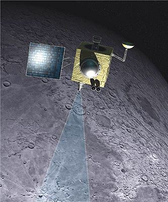
Artists impress of Chandrayaan-1 at the moon. Credit: ISRO

[/caption]
Following the fifth and final orbit raising maneuver which put Chandrayaan-1 closer to the moon, the spacecraft snapped the first picture of its final destination. This clear, crisp image of the moon While the images are still being processed and are not available yet, mission managers says the images bode well for spacecraft’s mission to map the entire moon’s surface with its Terrain Mapping Camera. And all systems are go for the final maneuver on November 8, which will put Chandrayaan-1 in lunar orbit.

After launch on October 22, the spacecraft was first injected into an elliptical 7-hr orbit around Earth, at 255 km from Earth at perigee (its closest point) and 22,860 km away at apogee, its farthest point. After five engine firings, Chandrayaan-1 has spiraled outwards in increasingly elongated ellipses around Earth, until it reached its lunar transfer orbit on November 4.

Chandrayaan-1 in its lunar transfer orbit.  Credit: ISRO
Chandrayaan-1 in its lunar transfer orbit. Credit: ISRO

In the final maneuver, engineers fired the spacecraft’s 440 Newton liquid-fuel propelled engine for about two and a half minutes. The lunar transfer orbit’s farthest point from Earth is about 380,000 km.

On November 8, as it nears the moon, the spacecraft’s engine will be fired again to slow the spacecraft, allowing the moon’s gravity to capture it, and then it will go into an initial elliptical orbit around the moon. A group of engineers from JPL are assisting the engineers from India, acting as experienced back-up for the “first-time-flyers” from India. And everything has gone smoothly thus far.

The spacecraft will make observations from the initial orbit, and then the orbit will be lowered a 100 km circular polar orbit. Following this, the Moon Impact Probe (MIP) will be ejected, impacting the lunar surface. Then the main mission will begin with Chandrayaan-1 exploring the moon from orbit with its array of instruments for two years.

Source: Bharat Chronicle

PAMELA Results Mean Only One Thing: Please Trust the Scientific Process

The PAMELA Spacecraft

[/caption]
Scientists from the PAMELA (Payload for Antimatter/Matter Exploration and Light-nuclei Astrophysics) orbiting spacecraft have published preliminary results, putting an end to months of speculation about the first direct detection of dark matter. The science team was, in essence, “forced” to publish before they had conclusive results because other scientists “pirated” data from the team. “We wanted to make our final results available to the scientific community once the data analysis was finalised,” PAMELA member Mirko Boezio said in an article in Physicsworld.com. “Given that our preliminary conference data are starting to be used by people, we felt this was a necessary step — not least because it provides a proper reference that correctly acknowledges the whole PAMELA collaboration and is available to the scientific community at large.” This is not the way the PAMELA team wanted to present their results, but really, they had no choice.

In a preprint on arXiv, the team says PAMELA has seen more positrons above a certain energy (10GeV) than can be explained by known physics. This excess seems to match what dark matter particles would produce if they were annihilating each other at the center of the galaxy. This excess, the authors say, “may constitute the first indirect evidence of dark-matter particle annihilations.” But they add that there could yet be other explanations, such as that positrons of this kind of energy can also be generated by nearby pulsars.

The science team will need to gather more data and do more work to be able to distinguish between the positron signature of dark matter annihilation and the positron signature of pulsars.

Two previous papers were published based on photos taken of slides of preliminary data that were shown at a science conference by the PAMELA team. See their papers here and here.

We humans are a curious and impatient lot. But we have to allow scientists to do their job, and do it the best way that science allows. Science done right does not mean secrecy or concealment. It means not speculating and waiting to announce results until proof positive. A similar event happened earlier this year with the Phoenix team and the detection of perchlorates. The Phoenix science team was forced to call a press conference to end all the speculation. Right now, the PAMELA team cannot say conclusively one way or the other whether they’ve made a direct detection of dark matter. Given enough time and more data, they will. Unless someone else steals the show again.

Sources: Physicsworld, arXiv, arXiv blog

Microbial Life on the Moon?

Shackelton Crater (and Earth) as seen by Kaguya. Credit: JAXA

[/caption]

One astrobiologist claims the deep, dark craters on the Moon might contain traces of early life from meteorites blasted off the Earth by asteroids billions of years ago. Joop Houtkooper, from the University of Giessen in Germany says studying these craters could reveal clues about the origin and evolution of life on Earth or even contain remnants of life from other planets in the Solar System, such as Mars. Houtkooper is also one of the few scientists who insist that the experiments done by the Viking Mars Landers in the 1970’s actually did reveal microbial life in the Martian soil, and earlier this year, Houtkooper predicted microbes could be detected by NASA’s Phoenix lander. So, could this new claim about microbes on the Moon be just the latest in a long series of contentious claims, or is Houtkooper onto something?

Houtkooper said the best place for finding evidence of life is on the moon is within the Shackleton Crater at the Moon’s south pole. Houtkooper presented his ideas at the recent 2008 European Planetary Science Congress in Germany. However, this was before results were released from the Japanese Kaguya lunar orbiter, which peered into Shackleton Crater and found no appreciable evidence of water ice. So, while ice on the moon hasn’t been ruled out completely, right now, the evidence isn’t there.

But Houtkooper said the evidence could come in the form of organic molecules, fossil remains, dead organisms, or even organisms in a dormant state that could be revived, such as bacterial spores. He said it is even possible that microbes could have survived for a short while after impact. Although there is no atmosphere to support life today, a temporary, thin atmosphere could have formed shortly after an impact event, as water and gases from the space rock vaporized, Houtkooper claimed.

The permanently shaded craters would be at almost a constant deep freeze temperature of -248ºC, ideal for freezing water and gases such as nitrogen, carbon dioxide or methane, and preserving traces of life undisturbed by sunlight and solar winds.

Other astrobiologists say the theory is possible, but would be a long shot.

“The microbial system on Earth extends to a depth of several kilometers into the crust, and so rocks blasted off the Earth by asteroid impacts could well have contained microbes,” said astrobiologist Malcolm Walter from the University of New South Wales in Sydney.

“I’d be very conservative about this idea,” said Lewis Dartnell, an astrobiologist at University College London (UCL) in the United Kingdom. “If, say, a comet landed right in the middle of a crater, then it’s possible”.

While Houtkooper agreed the idea is controversial, he maintains that there’s a good chance that remains of life could be found – and the latest mission to the Moon could provide the proof. India’s Chandrayaan-1 space probe launched in October will be specifically looking for ice deposits at the lunar poles.

“The long-existing knowledge about the Moon’s rotation axis implies that there are places in eternal shadow at the Moon’s poles,” Houtkooper said. “That means exceptionally low temperatures at, and some depth below, the surface there.”

Source: Cosmos Magazine

Where In The Universe Challenge #28

Here’s your image for this week’s “Where In The Universe” challenge. Take a look and see if you can name where in the Universe this image is from. Give yourself extra points if you can name the spacecraft responsible for the image. The new way we’re doing this challenge is that we’ll provide the image today, but won’t reveal the answer until tomorrow. This gives you a chance to mull over the image and provide your answer/guess in the comment section — if you dare. Check back tomorrow on this same post (reminder: no new post tomorrow — come back to this one) to see how you did!

UPDATE (11/6): The answer has now been posted below. If you haven’t made your guess yet, no peeking before you do!!


I have to say, I am impressed with the knowledge of you UT readers! Great job! Yes, it is Tycho’s Supernova Remnant, taken by the Chandra spacecraft. This is a bubble of hot gaseous supernova debris (green and red) inside a more rapidly moving shell of extremely high-energy electrons (blue). These features were created as the supersonic expansion of the debris into interstellar gas produced two shock waves – one that moves outward and accelerates particles to high energies, and another that moves backward and heats the stellar debris. The Chandra X-ray Observatory, which was launched and deployed by Space Shuttle Columbia on July 23, 1999, took this image in 2005.

Learn more about the image here.

And I’m sorry about the delay in posting the answer.

NASA News Too Depressing for a Headline

OK, I give up. I’ve sat here for about a half an hour trying to come up with a headline for this news piece. Actually, there are three different news items I’m combining into one article. One is fairly good news, the other two are very depressing.

First the good news: Today, the first major flight hardware of the Ares I-X rocket arrived in Florida to begin preparation for the inaugural test flight of NASA’s next-generation launch system. But amid this tangible event of moving toward the future comes bad financial news about the Constellation program. Congressional investigators have concluded that the Constellation program is likely to cost $7 billion more than budgeted if it is going to be ready to fly by its target date of March 2015. Without extra money, it could be delayed by 18 months or more.

At the same time another report concludes that NASA would need an extra $2 billion a year to keep its shuttle fleet flying beyond 2010, a measure which would shorten the gap where NASA wouldn’t have a human rated vehicle available for access to space. But doing so would hamper plans to convert a launch pad and other facilities for moon missions, likely delaying Constellation even more.

More money for either Constellation or the shuttle program is just not in NASA’s budget, and shifting money around from other programs “would be disastrous,” NASA shuttle program manager John Shannon said. “What we’re trying to do is find a path that continues to keep Americans flying on American vehicles, but does not mortgage the future of manned space flight,” he said. “We really have to step back and think very hard about what we want the future to look like, and make sure that we’re not going to make it something that is not achievable.”

I need ideas for a headline for this article. Readers — comments?

Both Republican presidential candidate John McCain and Democratic presidential candidate Barack Obama have said they would increase NASA’s budget by $2 billion to minimize the gap between shuttle retirement and the first piloted flights of Ares 1 rockets and Orion crew capsules. (This is being written before the election results are in.) But even that won’t be enough to solve all of the problems.

The Congressional Budget Office report listed several of problems facing the Ares I rocket and the Orion capsule, which NASA hopes will return astronauts to the moon by 2020. Among them are difficulties in developing an engine for Ares and a heat shield for Orion. “NASA has identified several problems associated with the Ares I that could delay successful development of the vehicle,” according to the 18-page report. Read the report here.

We’ve discussed all the issues previously on Universe Today, including intense shaking on liftoff, and concerns that Ares could crash into the launch gantry.

NASA officials said they were studying the report. But agency managers insist the program is on track.

At a news conference NASA held last week to counter reports of Constellation’s problems, Steve Cook, Ares project manager said, “The Ares I rocket is a sound design that not only meets the high safety standards required for a manned spacecraft, it is within budget, on schedule, and meets its performance requirements with margin.”

So what’s the real story? I’m not certain anymore. I desperately want to believe that the media (is that me, too?) overblowing the problems and NASA isn’t just looking through rose colored glasses. But the bad news keeps coming from all fronts.

NASA’s options other than the Ares appear limited.

One proposed option would extend the current space shuttle flight schedule through 2012, using the giant external fuel tanks and other hardware NASA has already planned to build. A second option calls for NASA to build more fuel tanks and hardware to keep flying three shuttle missions per year until 2015.

The CBO report also cautioned that the cost of more shuttle flights could only hurt Constellation under NASA’s limited budget.

Even by throwing more money at Constellation, the investigators also don’t think that NASA could speed up Constellation’s development, at least in the near term. They said NASA told them that “additional funding can no longer significantly change” the March 2015 target date of a first launch.

Even so, the Orlando Sentinel reports that NASA is looking at radical changes in the program to see if it can speed up development.

According to former astronaut Eileen Collins, currently a member of the NASA Advisory Council, one option under consideration would eliminate features needed to go to the moon and turn it a simple craft that could ferry crew and cargo to the space station. That would mean further delays for the real reason for Constellation: returning to the moon.

I thought we had some good news about Constellation last week. But this seems depressing. Too depressing for a headline.

Sources: NASA, Orlando Sentinel, Florida Today

5 Years At Mars: The Best of Mars Express

Water ice in a North Pole crater. Credit: ESA/DLR/FU Berlin (G. Neukum).

[/caption]
In December, the Mars Express spacecraft will celebrate the fifth anniversary of its arrival at Mars. In observation of this milestone the German Aerospace Center DLR has put together a collection of some of the best images from the High-Resolution Stereo Camera (HRSC), the main camera on board the spacecraft. The stunning, high resolution images this instrument has produced of Mars’ surface are nothing short of jaw dropping, and they have provided new perspectives and new discoveries about our neighboring planet. One of the iconic images from Mars Express is the image above of water ice inside a crater near Mars North Pole.

And here’s more from The Best of Mars Express:

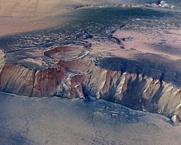
Echus Chasma mosaic.  Credits: ESA/DLR/ FU Berlin (G. Neukum)
Echus Chasma mosaic. Credits: ESA/DLR/ FU Berlin (G. Neukum)

My personal favorite is the image above of Echus Chasma, located in the Lunae Planum high plateau, north of Valles Marineris the ‘Grand Canyon’ of Mars. It doesn’t take much imagination to consider the possibility that once, gigantic water falls may have plunged over these 4,000 meter high cliffs on to the valley floor. See more of Echus Chasma here.

Here’a another of my favorites, this perspective color view of Coprates Chasma and the “Grabenkette” (a chain of depressions or rifts in Mars’ surface) Coprates Catena in an eastern section of Valles Marineris.
Coprates Chasma and the "Grabenkette" Coprates Catena in an eastern section of Valles Marineris. Credit: ESA/DLR/FU Berlin (G. Neukum).

The ability of the HRSC to provide “perspective” views — images that are not just straight down camera shots — are what sets the Mars Express mission apart from all the other orbiting spacecraft. When seen in full resolution (please, go download the biggie image here) these 3-D perspective views, are mind blowing!

In March of this year, Ian wrote about these high resolution and 3-D images from Hebes Chasma, one of the deepest canyons on Mars, so see more images there, along with links to additional images and information.

Hebes Chasma Credit: ESA/DLR/FU Berlin (G. Neukum).

The HRSC is imaging the entire planet in full color, 3-D and with a resolution of about 10 meters. Selected areas will be imaged at two-meter resolution. One of the camera’s greatest strengths is he unprecedented pointing accuracy achieved by combining images at the two different resolutions. Another is its ability for 3-D imaging which reveals the topography of Mars in full color.

Mars North Pole.  Credit: ESA/DLR FU Berlin (G. Neukum)
Mars North Pole. Credit: ESA/DLR FU Berlin (G. Neukum)

Here’s another look at Mars north arctic region, with water ice visible in Chasma Boreale.

Below is a view of Aureum Chaos, located in the eastern part of Valles Marineris. This “chaotic” landscape is dominated by randomly oriented, large-scale mesas and knobs that are heavily eroded. These mesas range from a few kilometres to tens of kilometers wide.

Perspective colour view of Aureum Chaos, northerly direction.   Credit: ESA/DLR/FU Berlin (G. Neukum).
Perspective colour view of Aureum Chaos, northerly direction. Credit: ESA/DLR/FU Berlin (G. Neukum).

For a little more history on Mars Express, the spacecraft was launched on June 2, 2003 from Baikonur Cosmodrome on a Soyuz-Fregat rocket. The goal of Mars Express is to search for water and the possibility of Martian life. Mars Express is a European Space Agency (ESA) mission to the Red Planet involving a consortium of countries (primarily France, Germany, Great Britain, Ireland, Italy, Japan, the Netherlands, Norway, Russia, Sweden, Spain, and the United States). The mission consisted of the orbiter and the Beagle lander, which unfortunately crash landed on Christmas Day 2003. Mars Express is currently in its second mission extension, which goes until May 2009.
Phobos from Mars Express.  Credit: ESA/DLR/FU Berlin (G. Neukum).
Phobos from Mars Express. Credit: ESA/DLR/FU Berlin (G. Neukum).

And finally, Mars Express not only takes images the surface of the Red Planet, but also of Mars’ moon Phobos. On July 23 of this year, the spacecraft flew only 93 kilometers from Mars’ moon Phobos, and took the most detailed images ever of the small, irregular moon. Read more about the flyby here.

That’s just a taste of all the wonderful images taken in the last five years by Mars Express. Check out more images at the DLR site.

Source: DLR

Rover Sand Traps Provide Clues on Mars Climate

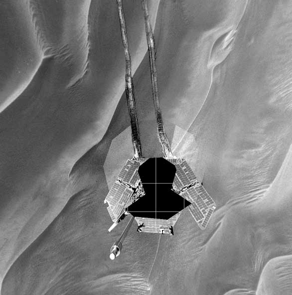
Opportunity's self portrait while stuck in the sand in 2005. Credit: NASA/JP

[/caption]

If you watched the “Five Years on Mars” documentary on the National Geographic channel about the Mars Exploration Rovers, you probably saw how both rovers have gotten stuck in some of the small sand dunes on Mars surface. These dune fields on Mars are a bit of a mystery to planetary geologists, and in fact, there is nothing like them on Earth. The fields of rippled sand on Mars, called Transverse Aeolian Ridges (TARs), are found over large areas across Mars. The dunes themselves are smaller than the gigantic dunes also found on Mars, but the fields are bigger than any sand ripple fields found on Earth. TARs hold clues to past and present climate processes, and since they can be death traps for rovers, scientists want to know more about these unusual features.

TARS are formed by the wind. If you frequently peruse the website for the HiRISE Camera on the Mars Reconnaissance Orbiter, you’ll see the word “aeolian” quite often in science themes and descriptions. Aeolian refers to any phenomena involving air movement.

TARS in the northern lowlands on Mars, as seen by HiRISE.  Credit: NASA/JPL/U of AZ
TARS in the northern lowlands on Mars, as seen by HiRISE. Credit: NASA/JPL/U of AZ

The ridges assume many shapes, such as simple ripples, forked ripples, snake-like sinuous waves, barchan-like (crescent-shaped) forms or complex, overlapping networks.

In 2005, the Opportunity rover got stuck in a small dune, called Purgatory Dune for six weeks with its wheels firmly mired in what planetary geologists believe was a small TAR. After the rover was finally freed, from images the rover took of the surrounding area, mission scientists noticed they were surrounded by dunes. (See this link for movies of the rover wheels turning in the sand.) They had to carefully drive around all the dunes, which slowed the progress down considerably. So it’s important to know where TARs are located to avoid landing among them on future rover missions.

One of the people studying TARs is Matt Balme, a research scientist with the the Planetary Science Institute. Balme and his colleagues have conducted a pole-to-pole planet survey of more than 10,000 images taken by the Mars Orbiter Camera, which was (is) on board the Mars Global Surveyor spacecraft.

Here’s what they found about TARs:

-They are more common in the southern hemisphere than in the northern.

-They are found in an equatorial belt between 30 degrees north and 30 degrees south latitude.

-They exist in two distinct environments: near layered terrain or adjacent to Large Dark Dunes (LLDs). Those adjacent to dunes have formed recently, while those near layered terrain are millions of years old.

-They are abundant in the Meridiani Planum region and in southern-latitude craters.

The Opportunity rover’s TAR encounter provided additional data, showing that at least that TAR was composed of an outer layer of granule-sized material ranging from about 2mm to 5 mm in diameter, Balme said. Beneath this was a mixed mass of fine and coarse particles.

Opportunity looks back at Purgatory Dune after escape.  See the other dunes in the surrounding area.  Credit: NASA/JPL
Opportunity looks back at Purgatory Dune after escape. See the other dunes in the surrounding area. Credit: NASA/JPL

TARs need two things to form, Balme explained: a supply of sediment and strong winds. The sediment requirement helps explain why they’re found near dunes and layered terrain and why they’re confined to a central belt around the planet, Balme said.

“My theory is that the very young TARs are found near the Large Dark Dunes, which are also very young, because the sand blowing off the dunes provides the energy needed to form TARs,” Balme said. “Meanwhile you have areas near layered landforms that used to have active sediment transport, but no longer. This shows a dynamic environment that has changed, and we might be able to use TARs as paleo markers to help decipher ancient climates.”

Current Martian circulation models don’t provide much evidence that wind patterns and atmospheric densities on Mars were significantly different in the past than from what they are today. “But I think the geology we are seeing suggests that there might have been different patterns and densities,” Balme said. “The observations we’re getting now from Mars Global Surveyor and the HiRISE camera are giving us really good data to drive the models.”

Although Blame and his team have discovered much about TARs, they still don’t know what materials compose the various TAR fields or why they’re seeing these large features on Mars but not on Earth.

“Over the next couple of years we should be seeing many more images from HiRISE that can give us more information, for example, about the heights versus spacing and whether TARs have more in common with dunes or the ripple fields found on Earth,” Balme said. “And they could provide insights into present and past climate patterns as we learn more about them and use that data to help drive general circulation models.”

Source: Planetary Science Institute

Phoenix Lander Weak But Responsive

The view from Phoenix. Credit: NASA/JPL/Caltech/U of AZ

[/caption]
After re-establishing communications with the Phoenix Mars Lander late last week, engineers have been able to communicate each day with the weakening spacecraft through relays with the Mars orbiters. But each day, Phoenix runs out of power by late afternoon or early evening. It is able to reawaken the next day after its solar arrays catch morning sunlight. Via Twitter, the lander said it is resting a lot, and hoping to get some strength back in order to do some more science. But each day the amount of time the sun is above the horizon at Mars north polar region diminishes. Additionally, dust raised by a storm last week continues to block some of the sunshine.

“This is exactly the scenario we expected for the mission’s final phase, though the dust storm brought it a couple weeks sooner than we had hoped,” said Phoenix Project Manager Barry Goldstein of NASA’s Jet Propulsion Laboratory, Pasadena, Calif. “We will be trying to gain some additional science during however many days we have left. Any day could be our last.”

Mission controllers at JPL and Lockheed Martin Space Systems are attempting this week to upload commands to be stored in the lander’s flash memory for science activities to be conducted when the lander wakes up each day.

“Weather observations are our top priority now,” said Phoenix Principal Investigator Peter Smith. “If there’s enough energy, we will try to get readings from the conductivity probe that has been inserted into the soil, and possibly some images to assess frost buildup.”

Source: JPL

Mars Methane Mystery Still Beckons

Discoveries of methane on Mars suggest it is actively being replenished. (Image: ESA/DLR/FU Berlin, G Neukum)

[/caption]
We’ve known about the methane in Mars’ atmosphere for over four years now. But we don’t know where it is coming from. On Earth, methane is produced from biological agents: rotting vegetation or flatulence from large animals like cows. But, of course, with our extensive explorations of Mars with rovers and high-resolution orbiting cameras, we’re fairly sure there are no Martian bovine equivalents chewing cud from the foliage on the Red Planet. Even if life existed in the past on Mars, methane is broken down quite quickly by sunlight, and scientists have calculated that methane should only exist for a few hundred years in the Martian atmosphere. The only possibility is that somehow, either chemically or biologically, the methane is being replaced on a regular basis. And now, two recent reports outlining separate discoveries on Mars make this methane mystery even more intriguing.

Methane was discovered on Mars by three independent groups in 2003 – 2004. One detection was made using the Mars Express spacecraft, another used observations from the Keck II and Gemini South telescopes, and the third used the Canada-France-Hawaii telescope.

And the mystery of how methane on Mars is being replenished has scientists continuing their observations in an effort to understand what’s happening on Mars. Michael Mumma of NASA’s Goddard Space Flight Center in Greenbelt, Maryland was one of the original methane discoverers. Observations he and his team have made over the last four years show methane is not spread evenly around Mars, but concentrated in a few “hotspots.” They have seen that methane clouds spanning hundreds of kilometers form over these hotspots and dissipate within a year – much shorter than the 300 – 600 years it was thought to take for atmospheric methane to be destroyed by sunlight. If methane is being destroyed so quickly, it also must be created at far higher rates than previously thought. Mumma reported these results at a planetary science conference last month.

Nili Fossae region on Mars, a methane "hotspot: Credit: NASA/JPL/U of AZ

One of the hotspots is Nili Fossae a fissure that has been eroded and partly filled in by sediments and clay-rich ejecta from a nearby crater. Could a living ecosystem be hidden here under the Martian surface? On Earth, subterranean microbes survive without sunlight, free oxygen, or contact with the surface. Additionally, the prospect becomes more intriguing when it is known on Earth, most deep-surface microbes are primitive, single-celled organisms that power their metabolism with chemical energy from their environment. These microbes are called “methanogens” because they make methane as a waste product.

Nili Fossae is one of the possible landing sites for the Mars Science Laboratory, the next generation of rover currently set to head off the Red Planet next year.

A pair of pit caves on Mars.  Could life exist inside? Credit: NASA/JPL/University of Arizona
A pair of pit caves on Mars. Could life exist inside? Credit: NASA/JPL/University of Arizona

But astrobiologists aren’t ruling out the possibility of some type of ongoing chemical process on Mars, which could be producing the methane. But even this is intriguing, because it means there are active processes going on inside Mars. One idea proposed in a recent paper is that methane clathrates are near the Martian surface, and are constantly releasing small amounts of methane as temperatures and pressure near the surface change.
Methane clathrates are solid forms of water that contain a large amount of methane within its crystal structure.

Caroline Thomas and her colleagues at the Universite de Franche-Comte say the clathrates could only exist near the surface of Mars if the atmosphere had once been methane rich. Otherwise the clathrates could never have formed. One possibility is that the atmosphere was once temporarily enriched by a comet impact. Also, the discovery of gray crystalline hematite deposits on the surface could be a proof of an early methane-rich Martian atmosphere.

Otherwise, the researchers say, the only other possibility is a biological source.

“Our results show that methane enriched clathrate hydrates could be stable in the subsurface of Mars only if a primitive CH4-rich atmosphere has existed or if a subsurface source of CH4 has been (or is still) present,” the researchers write.

So what does all this mean? The Mars Science Laboratory rover might have the ability to find out, or at least bring us closer to solving this mystery. Otherwise it will take a fairly large breakthrough from the other spacecraft and telescopes observing Mars. But it’s possible we might not fully understand why Mars has methane until humans actually go there themselves to find out.

Sources: arXiv, arXiv blog, New Scientist, Nature

Cassini’s ‘Skeet Shoot’ of Enceladus Produces Spectacular Images

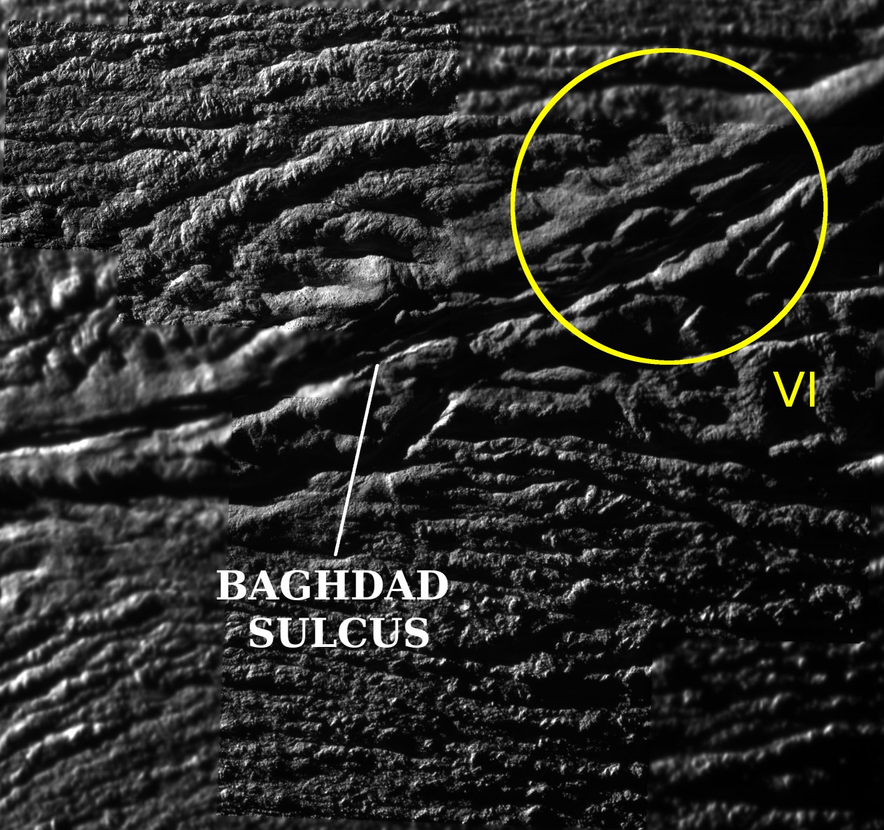
Baghdad Sulcus on Enceladus. Credit: CICLOPS

[/caption]
The Cassini spacecraft performed another ‘skeet shoot’ over Enceladus’ south pole on Friday, and returned some absolutely stunning images. Or as Carolyn Porco, the imaging team leader for the spacecraft said, “a bounty of positively glorious views of one of the most fabulous places in the solar system.” The resolution of the mosaic shown here is just 12.3 meters per pixel! Visible are large house-sized boulders, and the deep “tiger stripes” from which the plumes of material are being produced. One source of the jets producing the plumes is identified in the upper right on this image. Enjoy these great images now because the next flyby of Enceladus won’t be for another year. And at that time, the sun won’t be shining as predominantly on moon’s south pole, so next year the view of this region of Enceladus will be much dimmer. Here’s more…

This Cassini image was the first and highest resolution ‘skeet shoot’ narrow angle image captured during the October 31st flyby of Enceladus.

The image was taken with the Cassini spacecraft narrow-angle camera on October 31, 2008 at a distance of approximately 1691 kilometers (1056 miles) from Enceladus and at a Sun-Enceladus-spacecraft, or phase, angle of 78 degrees. Image scale is 9 meters (30 feet).

Enceladus.  Credit: CICLOPS
Enceladus. Credit: CICLOPS

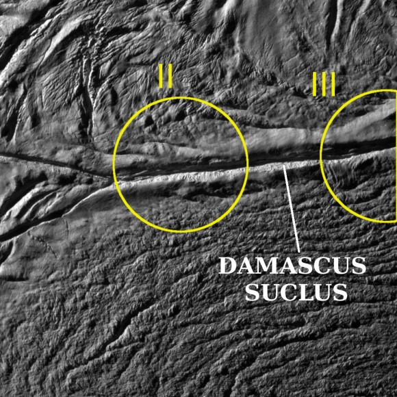
Here’s the 8th image from the flyby using the narrow angle camera The source region for jets II and III are identified. To identify jet source locations on the surface, imaging scientists carefully measured the locations and orientations of individual jets observed along the moon’s limb in Cassini images taken from multiple viewing angles. For each jet measurement, the researchers then computed a curve, or ground track, on the surface of Enceladus along which that jet might lie. The researchers were able to isolate eight areas as jet sources.

The image was taken with the Cassini spacecraft narrow-angle camera at a distance of approximately 5568 kilometers (3480 miles) from Enceladus and at a Sun-Enceladus-spacecraft, or phase, angle of 75 degrees. Image scale is 32 meters (105 feet) per pixel.

More Enceladus.  Credit: CICLOPS
More Enceladus. Credit: CICLOPS

Sources: CICLOPS (here and here)