Dr. Ken Kremer is a speaker, research scientist, freelance science journalist (KSC area,FL) and photographer whose articles, space exploration images and Mars mosaics have appeared in magazines, books, websites and calendars including Astronomy Picture of the Day, NBC, FOX, BBC, SPACE.com, Spaceflight Now, Science and the covers of Aviation Week & Space Technology, Spaceflight and the Explorers Club magazines. Ken has presented at numerous educational institutions, civic & religious organizations, museums and astronomy clubs. Ken has reported first hand from the Kennedy Space Center, Cape Canaveral, NASA Wallops, NASA Michoud/Stennis/Langley and on over 80 launches including 8 shuttle launches. He lectures on both Human and Robotic spaceflight - www.kenkremer.com. Follow Ken on Facebook and Twitter
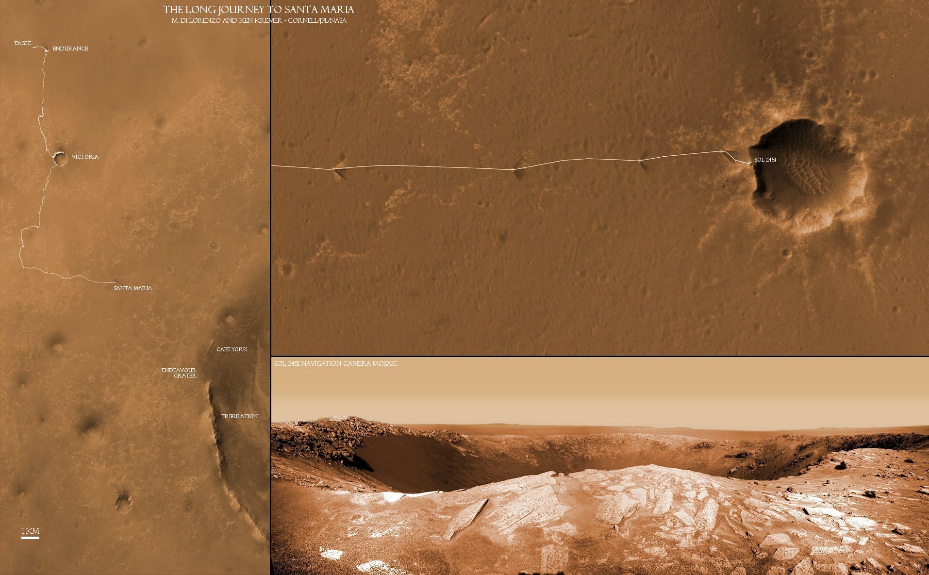
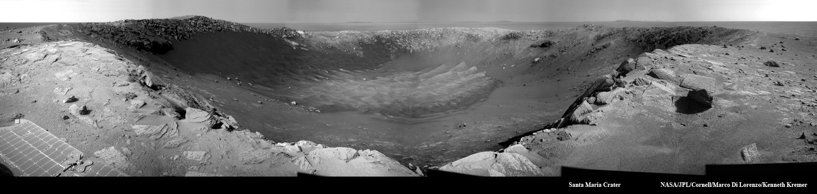
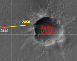
The Long Journey to Santa Maria: This collage of two maps and a new close up panorama of Santa Maria crater (bottom right) shows the route traversed by the Opportunity Mars rover during her nearly 7 year long overland expedition across the Meridiani Planum region of Mars. Opportunity arrived at the rim of Santa Maria Crater on Dec. 16, 2010 on Sol 2451. The rover has been on a crater tour since landing inside Eagle crater on Jan. 3, 2004. During her more than 26 km long journey she made numerous scientific discoveries along the way at Endurance and Victoria Craters. The rovers next destination is Endurance Crater - some 22 km wide - to investigate water bearing minerals at Cape York and Cape Tribulation which she will reach sometime in 2011. Credit: NASA/JPL/Cornell, Marco Di Lorenzo, Kenneth Kremer
[/caption]
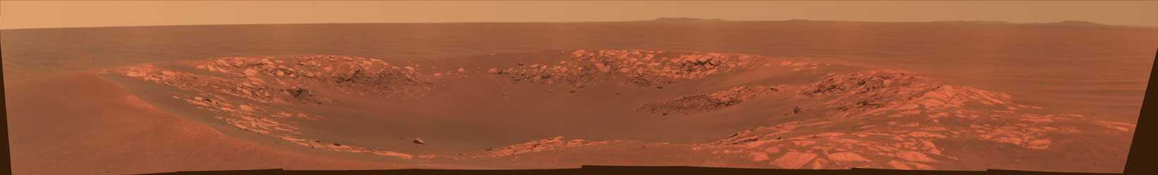
The Opportunity rover is now sending back a plethora of awesome views of Santa Maria Crater since just arriving at the western edge of the crater on Dec. 15 (Sol 2450). This intermediate stop on the rovers 19 km long journey from Victoria Crater to giant Endeavour Crater looks to be well worth the trip and affords another fine feather in the science teams cap.
Santa Maria appears to be “relatively unweathered and fresh”, according to Ray Arvidson, of Washington University in St. Louis. Arvidson is the deputy principal investigator for the Spirit and Opportunity rovers. A bounty of boulders and rocks from the ejecta ring the rim. The crater is roughly 90 meters in diameter with an estimated depth between 9 to 14 meters. It is somewhat oval in shape, not perfectly circular.
Opportunity looks back to the long road to Santa Maria
After initially driving to a distance of about five meters from the rim on Dec. 16 (Sol 2451), Opportunity has now carefully crawled even nearer to the precipice of the craters steep cliffs. At each spot the rover snaps a series of panoramic images to document the site scientifically and esthetically and plan the next sols drive.
The team back on Earth – and millions of kilometers away – must tread with extreme caution as Opportunity creeps ever closer to the edge lest she fall off a cliff. Whereas the cameras revealed a dramatic gaping hole on Dec. 16, Opportunity is now positioned close enough to point her cameras directly at the steep walled cliffs and towards the sand dunes at the crater floor crater unveiling another stunningly gorgeous Martian vista.
Compare the panoramas from Sols 2451 and 2454 above and below as Opportunity pulled up to the rim in stages and began exploring the crater environment from different vantage points.
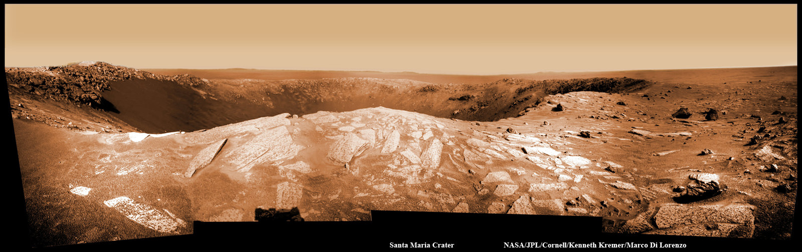
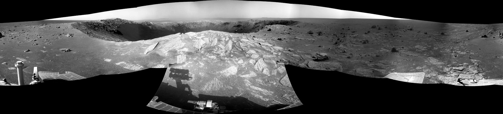
Panoramic view of Santa Maria Crater taken by Opportunity Mars rover about 5 meters from the rim on Dec 16, 2010 on Sol 2451. CRISM results suggest water bearing materials are located at the southeastern edge of the rim located roughly at the center of this image. Portions of distant Endeavour Crater are faintly visible as bumps on the horizon in the background. The northern and eastern rims are located from left to center. Cape Tribulation is to the right. Credit: NASA/JPL/Cornell, Kenneth Kremer, Marco Di LorenzoThe complete panoramic view of Santa Maria Crater taken by Opportunity Mars rover about 5 meters from the rim on Dec 16, 2010 on Sol 2451. Credit: NASA/JPL/Cornell, Jan van DrielPeering into Santa Maria Crater. Opportunity drove closer to within 5 meters of the rim and snapped this gorgeous panoramic vista unveiling the whole interior on Sols 2453 & 2354. Note the steep walls and sand dunes on the floor. Credit: NASA/JPL/Cornell, James CanvinPanoramic view revealing interior steep cliffs and sand dunes of Santa Maria Crater was taken within 5 meters of the rim on Sol 2454. Credit: NASA/JPL/Cornell, Marco Di Lorenzo, Kenneth Kremer
The rover handlers are highly adept at precisely maneuvering the 175 kg vehicle back and forth inside the danger zone at crater rims. After all Opportunity has been on a crater tour for her entire 7 year extended mission to the red planet and controllers at NASA’s Jet Propulsion Laboratory (JPL) have honed their driving techniques at countless locales both treacherous and dazzling, especially about the precipitous 50 meter cliff drops at Victoria Crater.
High priority activity on the west side of Santa Maria includes collecting the first pair in a series of long-baseline, high resolution stereo panoramas which will be used to create a digital elevation map in 3 D, according to Guy Webster, the Public Affairs Officer at NASA’s Jet Propulsion Laboratory (JPL) in Pasadena, Calif., which manages the Mars Rover mission for NASA.
The newly assembled crater maps – see the first mosaics herein – will be scrutinized and utilized for planning the best locations to visit during the upcoming multi-week science campaign. .
JPL engineers will move Opportunity in a counterclockwise direction around the rim from the Sol 2450 approach point.
“One last drive before the Christmas break will take us ~ 20m away to a lookout point, to set us up for another drive next week,” tweeted JPL Rover driver Scott Maxwell. “Last weekend’s drive around Santa Maria took us to this gorgeous new outlook. It’s grand here.”
“There are no plans to enter the crater.” Webster confirmed to me. There is no reason to take a risk when Opportunity is so close to those phyllosilicate clays at Endeavour which formed in water and have never before been directly analyzed on the Martian surface.
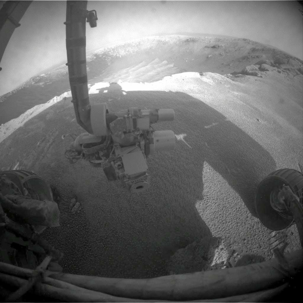
“Fisheye view of Santa Maria from the front hazcam camera with robotic arm instruments and two wheels. The RAT science drill is pointing to the left. . Credit: NASA/JPL/Cornell
The current plan calls for Opportunity to stay at Santa Maria through the upcoming Solar conjunction which starts in late January and ends in mid-February,” Webster stated.
The rover will remain stationary during that period and conduct a lengthy focused investigation of a specific spot using the instruments on the robotic arm – which include a rock drill, microscope and spectrometers.
“We will use the ‘no-new-commanding’ time of conjunction for a long-integration assessment of the composition of a selected target,” added Webster.
“The team plans to use Opportunity’s RAT- or Rock Abrasion Tool – on a target at Santa Maria,” says rover project manager John Callas of JPL. The RAT is a high tech device that uses a grinding wheel to cut into martian rocks and has performed far beyond expectation. The diamond embedded abrader teeth still have some life left, and the team wants to save some abrasion capability for the Endeavour rim targets.
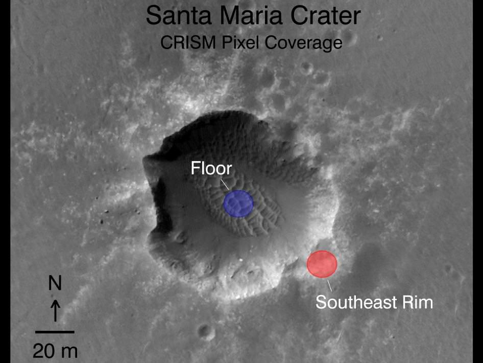
Orbital Observations at Santa Maria Crater. Opportunity arrived at the western rim of Santa Maria Crater, some 90 meters wide, on Dec. 16, 2010. Researchers are using data collected by a powerful mineral mapping spectrometer (CRISM) aboard NASA’s Mars Reconnaissance Orbiter (MRO) to direct the route which Opportunity is traversing on Mars during the long term journey to Endeavour crater. Spectral observations recorded by CRISM indicates the presence of water-bearing sulfate minerals at the location shown by the red dot on the southeast rim crater whereas the crater floor at the blue dot does not. This image was taken by the High Resolution Imaging Science Experiment (HiRISE) camera also on MRO. Credit: NASA/JPL-Caltech/Univ. of Arizona
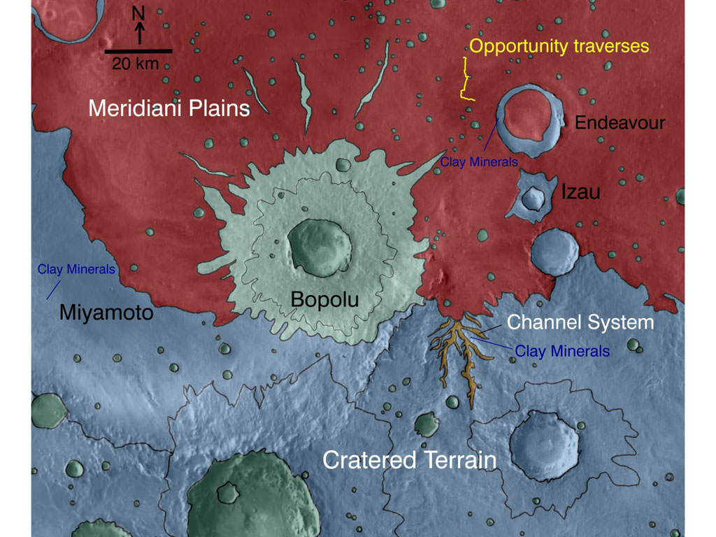
This map indicates geological units in the region of Mars around a smaller area where Opportunity has driven from early 2004 through late 2010. The blue-coded unit encompassing most of the southern half of the mapped region is ancient cratered terrain. In the northern region, it is overlain by younger sediments of the Meridiani Plains, punctuated by the even younger Bopulu impact. At Endeavour Crater, in the upper right near the gold line of Opportunity's traverse, ancient cratered terrain is exposed around the crater rim. Locations where orbital observations have detected clay minerals are indicated at the western edge of Endeavour and at two locations in the southern portion of the map. The mineral mapping was done by Sandra Wiseman and Ray Arvidson of Washington Universty in St. Louis based on observations by the Compact Reconnaissance Imaging Spectrometer for Mars (CRISM) on NASA's Mars Reconnaissance Orbiter.
[/caption]
NASA is using its powerful science surveyor orbiting more than 241 kilometers above Mars to target the surface explorations of the long lived Opportunity rover to compelling science targets on the ground. Opportunity is currently on a long term trek to the giant crater named Endeavour, some 22 kilometers in diameter, which shows significant signatures of clays and water bearing sulfate minerals which formed in the presence of flowing liquid water billions of years ago.
An armada of orbiters and rovers from Earth are carrying out a coordinated attack plan to unlock the mysteries of the red planet, foremost being to determine whether life ever arose on Mars.
On Dec. 15 (Sol 2450), Opportunity arrived at Santa Maria crater which is just 6 km distant from the western rim of Endeavour. Over the past 2 years, the rover has traversed more than two thirds of the 19 km distance from Victoria crater -her last big target – to Endeavour.
High resolution spectral and imaging mappers aboard NASA’s Mars Reconnaissance Orbiter (MRO) are enabling researchers on the rover team to prioritize targets and strategically guide Opportunity to the most fruitful locations for scientific investigations.
The on board CRISM mapping spectrometer has detected clay minerals, or phyllosilicates, at multiple locations around Endeavour crater including the western rim closest to Opportunity. CRISM is the acronym for Compact Reconnaissance Imaging Spectrometer for Mars. Images from MRO’s HiRISE camera are utilized to scout out the safest and most efficient route. See maps above and below.
“This is the first time mineral detections from orbit are being used in tactical decisions about where to drive on Mars,” said Ray Arvidson of Washington University in St. Louis. Arvidson is the deputy principal investigator for the Spirit and Opportunity rovers and a co-investigator for CRISM.
Clay minerals are a very exciting scientific find because they can form in more neutral and much less acidic aqueous environments which are more conducive to the possibility for the formation of life. They have never before been studied up close by science instruments on a landed mission.
Opportunity may soon get a quick taste of water bearing sulfate minerals at Santa Maria because spectral data from CRISM suggest the presence of sulfate deposits at the southeast rim of the crater. Opportunity has previously investigated these sulfate minerals at other locations along her circuitous traverse route – but which she discovered without the help of orbital assets.
“We’ve just pulled up to the rim of Santa Maria, and the workload is very high,” Steve Squyres informed me. Squyres, of Cornell University, is the Principal Scientific Investigator for NASA’s Spirit and Opportunity Mars rovers.
Opportunity drove to within about 5 meters of the crater rim on Dec. 16 (Sol 2451). JPL Mars rover driver Scott Maxwell tweeted this message ; “Today’s NAVCAM mosaic of Santa Maria Crater. Woo-hoo! Glorious and beautiful!” and this twitpic
Orbital Observations at Santa Maria Crater.
Opportunity just arrived at the western side of Santa Maria Crater, some 90 meters wide, on 15 December 2010. Researchers are using data collected by a powerful mineral mapping spectrometer (CRISM) aboard NASA’s Mars Reconnaissance Orbiter (MRO) to direct the route which Opportunity is traversing on Mars during the long term journey to Endeavour crater. Spectral observations recorded by CRISM indicates the presence of water-bearing sulfate minerals at the location shown by the red dot on the southeast rim crater whereas the crater floor at the blue dot does not. This image was taken by the the High Resolution Imaging Science Experiment (HiRISE) camera also on MRO. Credit: NASA/JPL-Caltech/Univ. of Arizona
The rover will conduct an extensive science campaign at Santa Maria by driving to different spots over the next several weeks and gathering data to compare observations on the ground to those from CRISM in orbit.
Opportunity Navcam camera view of Santa Maria Crater just 5 m from the rim on Sol 2451, Dec. 16, 2010. Click to enlarge
Santa Maria crater appears to be relatively fresh and steep walled and was likely created by a meteor strike only a few million years ago. Endeavour is an ancient crater with a discontinuous rim that is heavily eroded at many points. By exploring craters, scientists can look back in time and decipher earlier geologic periods in Mars history.
Scientists believe that the clay minerals stem from an earlier time period in Martian history and that the sulfate deposits formed later. Mars has experiences many episodes of wet environments at diverse locations in the past and climate-change cycles persist into the present era.
After the upcoming Solar Conjunction in February 2011, Opportunity will depart eastwards for the last leg of the long march to Endeavour. She heads for a rim fragment dubbed Cape York which spectral data show is surrounded by exposures of water bearing minerals. Cape York is not yet visible in the long distance images because it lies to low. See maps below.
Thereafter, Opportunity alters direction and turns south towards her next goal –
Cape Tribulation – which is even more enticing to researchers because CRISM has detected exposures of the clay minerals formed in the milder environments more favorable to life. Cape Tribulation has been clearly visible in rover images already taken months ago in early 2010.
Opportunity could reach Endeavour sometime in 2011 if she can continue to survive the harsh environment of Mars and drive at her current accelerated pace. Opportunity arrived at Mars in January 2004 for a planned 90 day mission. The rover has far surpassed all expectations and will soon celebrate 7 earth years of continuous operations on the red planet. Virtually all the data from Spirit and Opportunity are relayed back to Earth via NASA’s Mars Odyssey orbiter.
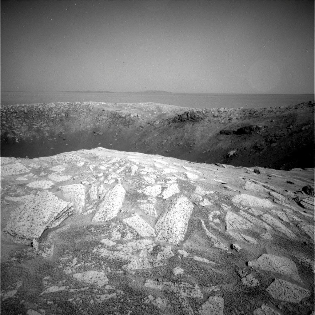
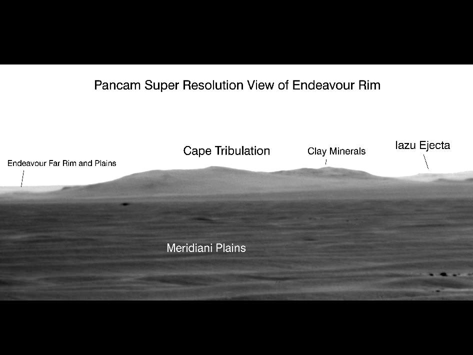
Opportunity used its panoramic camera in a super-resolution technique to record this view of the horizon on Sol 2298 (July 11, 2010) which shows the western rim of Endeavour Crater, including the highest ridge informally named “Cape Tribulation”. CRISM data revealed exposures of clay minerals at Cape Tribulation.
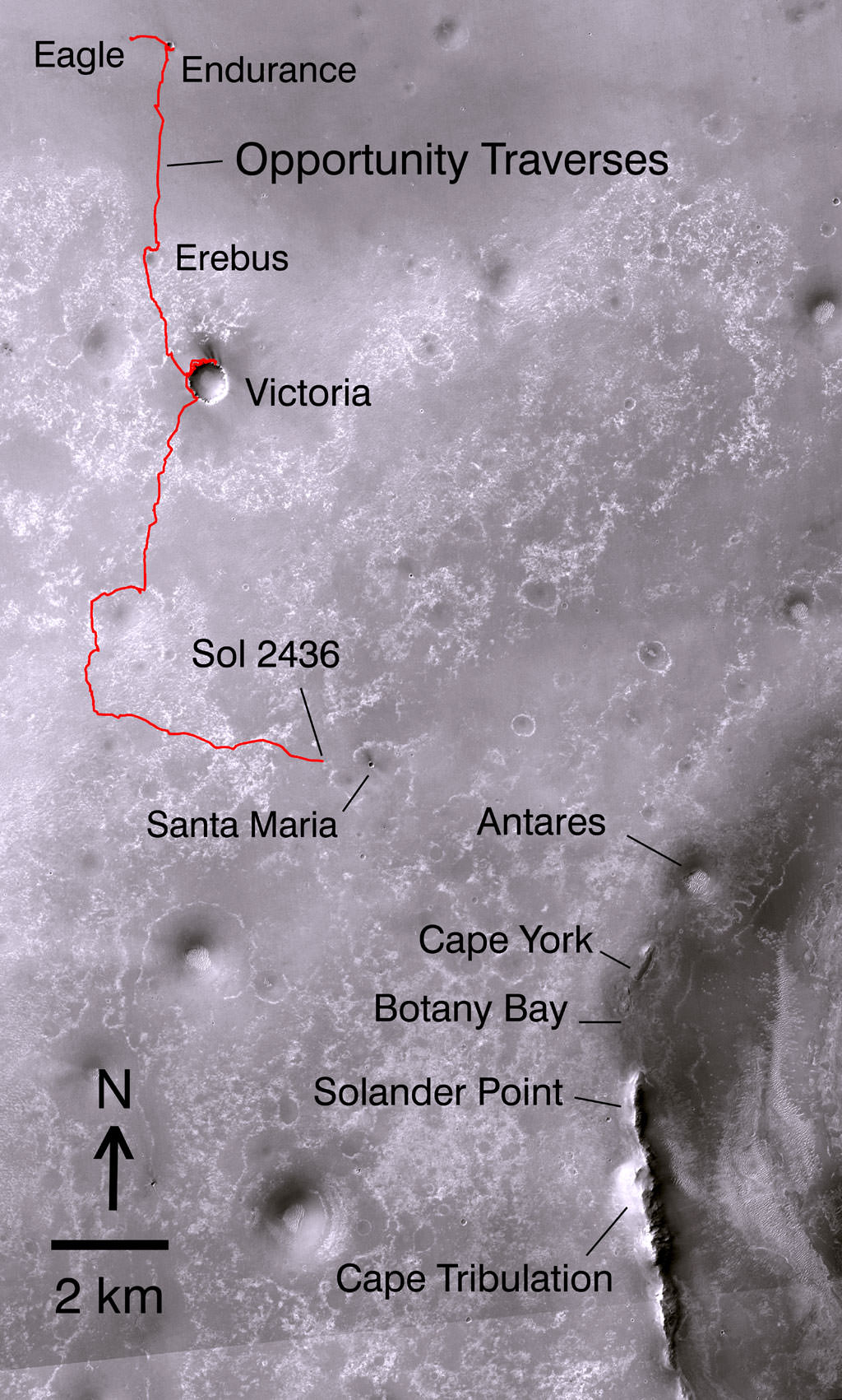
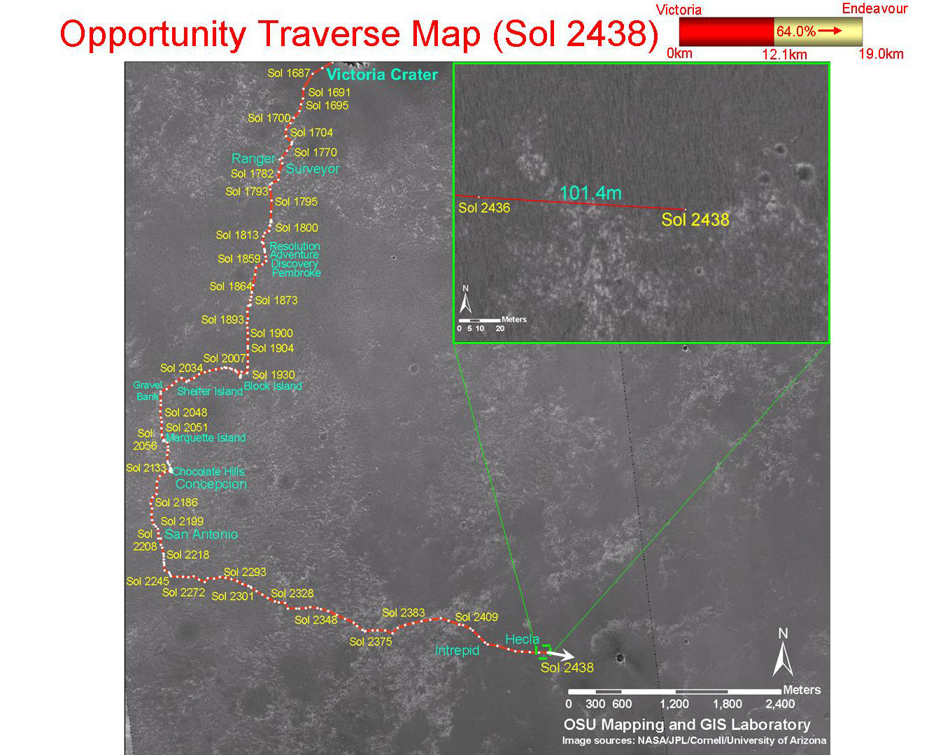
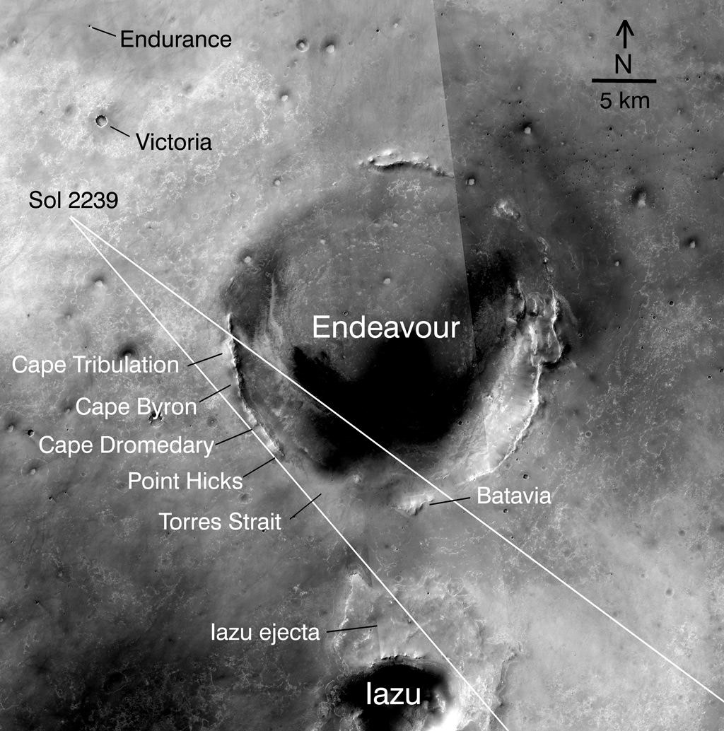
Opportunity’s Path on Mars Through Sol 2436
The red line shows where Opportunity has driven from the place where it landed in January 2004 — inside Eagle Crater, at the upper left end of the track — to where it reached on the 2,436th Martian day, or sol, of its work on Mars (Nov. 30, 2010). The map covers an area about 15 kilometers (9 miles) wide. North is at the top. Subsequent drives brought Opportunity to Santa Maria Crater, which is about 90 meters (295 feet) in diameter. After investigating Santa Maria the rover heads for Endeavour Crater. The western edge of 22-kilometer-wide (14-mile-wide) Endeavour is in the lower right corner of this map. Some sections of the discontinuous raised rim and nearby features are indicated with informal names on the map: rim segments “Cape York” and “Solander Point”; a low area between them called “Botany Bay”; “Antares” crater, which formed on sedimentary rocks where the rim was eroded down; and rim fragment “Cape Tribulation,” where orbital observations have detected clay minerals. The base map is a mosaic of images from the Context Camera on NASA’s Mars Reconnaissance Orbiter.
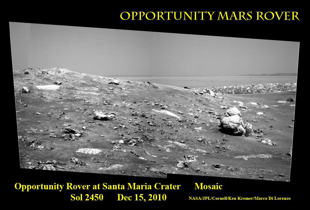
Opportunity arrived at Santa Maria crater on Sol 2450 (Dec 15, 2010) and will spend the next few weeks exploring around the 80 meter wide crater. In the background is Endeavour crater, 6 km away. This mosaic was assembled from pancam images. Credit: NASA/JPL/Cornell/ Ken Kremer, Marco Di Lorenzo
[/caption]
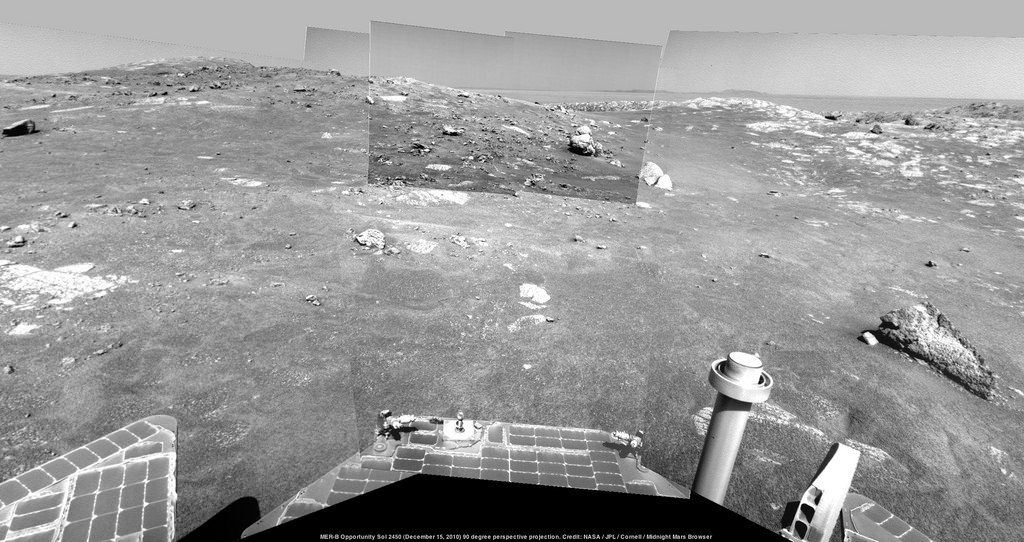
NASA’s Opportunity Mars rover arrived today (Dec .15) at Santa Maria crater on Sol 2450. She sits just 20 meters from the crater rim. A multitude of inviting rocks and boulders are strewn about the 80 meter diameter crater, making this a Martian geologists dream.
And so it goes too for a Martian photographer with lots to shoot and with the giant 14 km wide Endeavour crater serving as backdrop and coming into ever clearer focus.
Santa Maria is just 6 km from the western rim of Endeavour (see panoramic mosaics above and below).
MRO image of Santa Maria crater from orbit with Sol markers. Credit: NASA/JPL/UA/MSSS/Eduardo Tesheiner
Opportunity has been on a swift advance since departing from Intrepid crater in mid-November and driven about 1.5 km over very smooth terrain. The rover continues to benefit from a bounty of solar power and upgraded software enabling longer and more frequent days of drives. Opportunity has now driven a total of 26.4 km.
Opportunity Sol 2450 (Dec 15, 2010) 90 degree perspective projection around Santa Maria crater. Credit: NASA/JPL/Cornell/Midnight Mars Browser
The rover team is planning for an extensive and multi week science campaign at Santa Maria using all the instruments and cameras at their disposal.
Opportunity will spend the holiday season and the upcoming Solar conjunction exploring around Santa Maria according to Matt Golembek, Mars Exploration Program Landing Site Scientist at the Jet Propulsion Laboratory (JPL), Pasadena, Calif.
There will be no uplink commanding to the spacecraft around the actual conjunction period from Jan. 28 to Feb. 12 (UTC) out of caution that the command transmission could be disrupted.
The team plans a sophisticated wide-baseline stereo-imaging survey of Santa Maria by having Opportunity drive to several positions halfway around the crater. A mineral survey will be carried out using the spectrometers, microscope and drill – known as the RAT or rock abrasion tool – located at the terminus of the rover’s robotic arm.
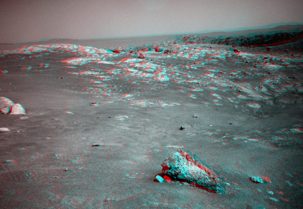
3 D view of the feature resembling an “Alligator’s Tail” near the rim of Santa Maria crater on Sol 2450. Credit: NASA/JPL/Cornell/Stu Atkinson
See several additional amateur mosaics below – including 3 D images – from all of us at unmannedspaceflight .com.
The rover is now at the two thirds mark of a 19 km (12 mile) journey from Victoria crater on the road to reach the rim of the scientifically rich environs of Endeavour crater sometime later in 2011. Opportunity explored the rim and interior of Victoria from mid-2006 to mid-2008.
Santa Maria is the largest feature that Opportunity will explore between Victoria and Endeavour craters. The team assigns informal names to craters visited by Opportunity based on the names of historic ships of exploration in human history. See Opportunity traverse maps below.
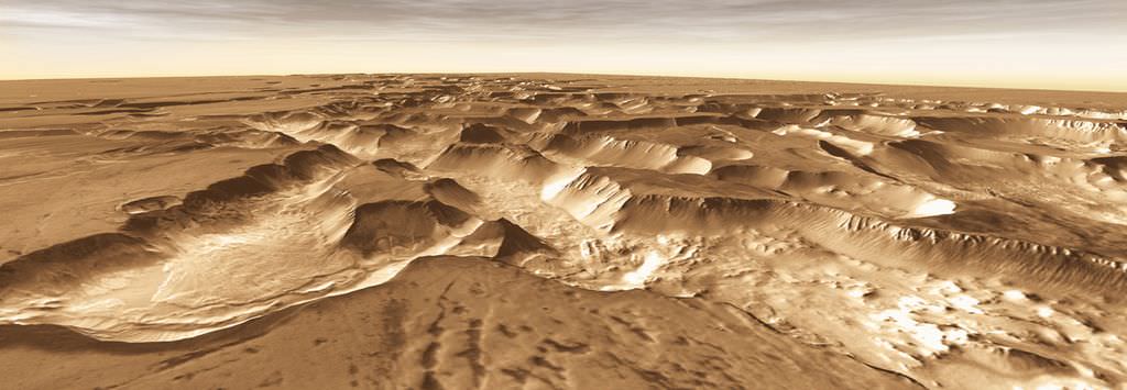
Noctis Vista: West of Valles Marineris lies a checkerboard named Noctis Labyrinthus, which formed when the Martian crust stretched and fractured. As faults opened, they released subsurface ice and water, causing the ground to collapse. This westward view combines images taken during the period from April 2003 to September 2005 by the Thermal Emission Imaging System instrument on NASA's Mars Odyssey orbiter. It is part of a special set of images marking the occasion of Odyssey becoming the longest-working Mars spacecraft in history. The pictured location on Mars is 13.3 degrees south latitude, 263.4 degrees east longitude. Image Credit: NASA/JPL-Caltech/ASU
[/caption]
At 3,340 days and counting, NASA’s Mars Odyssey orbiter established a new record for longevity as of Dec. 15 and thereby worked longer at the red planet than any other spacecraft in human history.
The previous Martian record holder was the Mars Global Surveyor (MGS) orbiter which operated in orbit from Sept. 11, 1997 to Nov. 2, 2006 until contact was lost following a computer glitch.
Odyssey has made numerous high impact scientific discoveries along the way. The probe also relayed most of the science data from Spirit, Opportunity and Phoenix and will continue that task for NASA’s upcoming Mars Science Laboratory (MSL) rover named Curiosity.
The spacecrafts name – 2001 Mars Odyssey – was chosen as a tribute to the vision and spirit of space exploration as embodied in the works of renowned science fiction author Arthur C. Clarke – including the movie “2001: A Space Odyssey”.
It was way back on Oct. 24, 2001 that the Odyssey spacecraft fired its main engine to brake the crafts speed and allow it to be captured by Mars and enter a highly elliptical orbit. A technique known as aerobraking was used over the next three months to fly through the upper atmosphere and utilize drag to gradually lower the crafts altitude and eventually enter its mapping orbit.
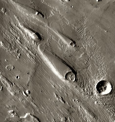
Ares Vallis: In Ares Vallis, teardrop mesas extend like pennants behind impact craters, where the raised rocky rims diverted the floods and protected the ground from erosion. Scientists estimate the floods had peak volumes many times the flow of today's Mississippi River. The pictured location on Mars is 15.9 degrees north latitude, 330 degrees east longitude. Image Credit: NASA/JPL-Caltech/ASU
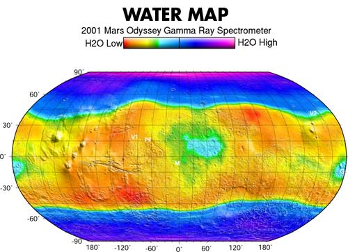
Science operations began in earnest in February 2002. Within a few months, Odyssey made the key discovery of the entire mission when it found that the polar regions harbored substantial caches of water ice within a meter of the dry surface of Mars.
The detection of water – in the form of hydrogen — from orbit using the crafts Gamma Ray Spectrometer led directly to the proposal for the Phoenix mission which confirmed the discovery in 2008. Phoenix landed directly on top of vast sheets of frozen water ice in the northern polar region of Mars and scooped up samples of ice for analysis by the landers science suite.
Another notable achievement by Odyssey during the primary mission phase was to complete a survey of the radiation environment to determine the radiation-related risk to any future human explorers who may one day go to Mars.
In another first, Odyssey’s instruments globally mapped the amount and distribution of many chemical elements and minerals that make up the martian surface. Such data helps explain how the planet’s landforms developed over time, provides clues to the geological and climatic history of Mars, informs about the potential for finding past or present life and where are the best locations to search for life and send future landers such as the Curiosity rover set to launch in November 2011.
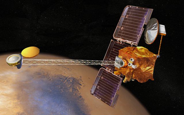
Artist concept of Mars Odyssey probe in orbit since Oct. 24, 2001
Mars Odyssey is equipped with three primary science instruments to accomplish the goals set out in NASA Mars Exploration Program:
• THEMIS (Thermal Emission Imaging System), for determining the distribution of minerals, particularly those that can only form in the presence of water;
• GRS (Gamma Ray Spectrometer), for determining the presence of 20 chemical elements on the surface of Mars, including hydrogen in the shallow subsurface (which acts as a proxy for determining the amount and distribution of possible water ice on the planet); and,
• MARIE (Mars Radiation Environment Experiment), for studying the radiation environment.
The primary mission lasted until August 2004. Since then the mission lifetime has been extended several times and further extensions are in the works according to Guy Webster, the Public Affairs Officer at NASA’s Jet Propulsion Laboratory (JPL) in Pasadena, Calif., which manages the Odyssey mission.
“We are currently in the fourth extended mission which is funded through the end of September 2012,” Webster told me. “Extended missions are funded for about a one-Mars-year period, which is approximately equal to two years. The next extended mission period will be during the MSL’s prime surface mission and Odyssey is an integral part of the effort to relay MSL’s data from the surface and back to Earth.”
MSL is slated for an August 2012 landing on Mars. “It is expected that Odyssey will be approved for a fifth extended mission,” said Webster.
“The total investment in this mission so far — including development, assembly & test, launch, and operations — is $508 million,” added Webster.
Udzha Crater: Although it is 45 kilometers (28 miles) wide, countless layers of ice and dust have all but buried Udzha Crater. Udzha lies near the edge of the northern polar cap, and only the topmost edges of its crater rim rise above the polar deposits to hint at its circular shape. The pictured location on Mars is 81.8 degrees north latitude, 77.2 degrees east longitude. Image Credit: NASA/JPL-Caltech/ASU
A huge bonus of scientific accomplishments has been enabled during the extended mission phase that otherwise would not have been possible.
“The extra years have allowed us to build up the highest-resolution maps covering virtually the entire planet,” said Odyssey Project Scientist Jeffrey Plaut of JPL.
The maps were constructed using nearly 21,000 images taken by the THEMIS camera which was built and is operated by Arizona State University, Tempe. Surface details as small as 100 meters (330 feet) wide are visible. Check out this slide show of some of Odyssey’s greatest hits as compiled by the camera team and NASA: http://www.nasa.gov/mission_pages/odyssey/images/all-stars.html
Chasma Boreale is a long, flat-floored valley that cuts deep into Mars' north polar icecap. Its walls rise about 1,400 meters (4,600 feet) above the floor. Where the edge of the ice cap has retreated, sheets of sand are emerging that accumulated during earlier ice-free climatic cycles. Winds blowing off the ice have pushed loose sand into dunes and driven them down-canyon in a westward direction, toward our viewpoint. This scene combines images taken during the period from December 2002 to February 2005 by the Thermal Emission Imaging System instrument on NASA's Mars Odyssey orbiter. The pictured location on Mars is 84.9 degrees north latitude, 359.1 degrees east longitude. Image Credit: NASA/JPL-Caltech/ASU
The ability to monitor seasonal changes on Mars from year-to-year, such as the cycle of carbon-dioxide freezing out of the atmosphere in polar regions during each hemisphere’s winter, is another example of bonus science from the extended mission.
“It is remarkable how consistent the patterns have been from year to year, and that’s a comparison that wouldn’t have been possible without our mission extensions,” Plaut said.
The science team comprises numerous additional partners including the Russian Aviation and Space Agency, the University of Arizona, and Los Alamos National Laboratory.
Odyssey has served as the primary means of communications for NASA’s Mars surface explorers in the past decade and will continue that role for the upcoming Curiosity rover.
“More than 95 percent of the data from Spirit and Opportunity and approximately 79 percent of the data from Phoenix was relayed by Odyssey,” Webster stated.
Given the propellant reserves on board, Odyssey could continue operating until at least about 2016 and perhaps even well beyond if the ships systems remain healthy.
“21.6 kg of propellant remains with an average consumption rate of about 1.4 kg per year,” according to Webster. “However, there are other elements of the spacecraft that might suggest that Odyssey’s life expectancy could be closer to six years. Lifetime issues are extremely difficult to estimate. The best policy is to reevaluate the spacecraft’s health at regular intervals, and prior to important events, and determine if we’re up to a given task. So far we have been.”
Odyssey remains in good shape overall and will continue to actively pursue many science investigations in the years ahead.
Among the top priorities are extended coverage of Mars with mid-afternoon imaging by THEMIS. The orbit was adjusted last year to enable surface observations in mid-afternoon instead of late afternoon. Another goal is to extend year-to-year comparisons of seasonal changes on Mars.
Concerning the status of the science instruments, Webster informed me, “THEMIS and two parts of the GRS suite — the neutron spectrometer and the high-energy neutron detector — are currently in use. The third sensor for that suite — the gamma ray detector — is no longer in use. The payload’s MARIE radiation experiment stopped taking measurements several years ago.”
Lockheed Martin Space Systems, Denver built the Odyssey spacecraft which is operated in partnership with JPL.
Mars Odyssey was launched on April 7, 2001. For more information visit the mission website: http://mars.jpl.nasa.gov/odyssey/
Noctis Canyon: A false-color mosaic focuses on one junction in Noctis Labyrinthus where canyons meet to form a depression 4,000 meters (13,000 feet) deep. Dust (blue tints) lies on the upper surfaces, while rockier material (warmer colors) lies below. The pictures used to create this mosaic image were taken from April 2003 to September 2005 by the Thermal Emission Imaging System instrument on NASA's Mars Odyssey orbiter. The pictured location on Mars is approximately 13 degrees south latitude, 260 degrees east longitude. Image Credit: NASA/JPL-Caltech/ASU Bunge Crater Dunes: Fans and ribbons of dark sand dunes creep across the floor of Bunge Crater in response to winds blowing from the direction at the top of the picture. The frame is about 14 kilometers (9 miles) wide.The pictured location on Mars is 33.8 degrees south latitude, 311.4 degrees east longitude. Image Credit: NASA/JPL-Caltech/ASDual Crater: If a meteorite breaks in two shortly before hitting the ground, the typical bowl shape of a single impact crater becomes doubled. The two circular blast regions intersect, creating a straight wall separating the two craters. At the same time, 'wings' of ejected debris shoot out to the side. The image covers an area 13 kilometers (8 miles) wide. Image Credit: NASA/JPL-Caltech/ASU
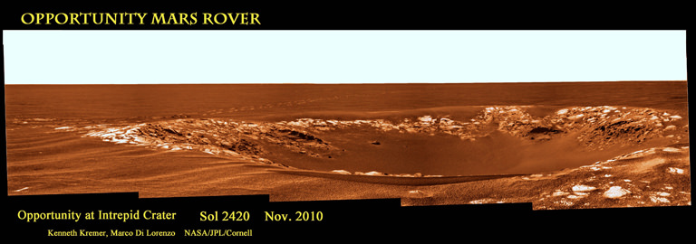
Opportunity arrived at ‘Intrepid’ Crater on Mars during November 2010 and drove around crater rim. See rover wheel tracks at left. Intrepid crater was named in honor of the Apollo 12 lunar module named “Intrepid” – which landed two men on the moon on 19 November 1969. This false color mosaic was assembled from pancam images taken by Opportunity on Sol 2420 (Nov 14, 2010). Mosaic Credit: Kenneth Kremer, Marco Di Lorenzo NASA/JPL/Cornell
[/caption]
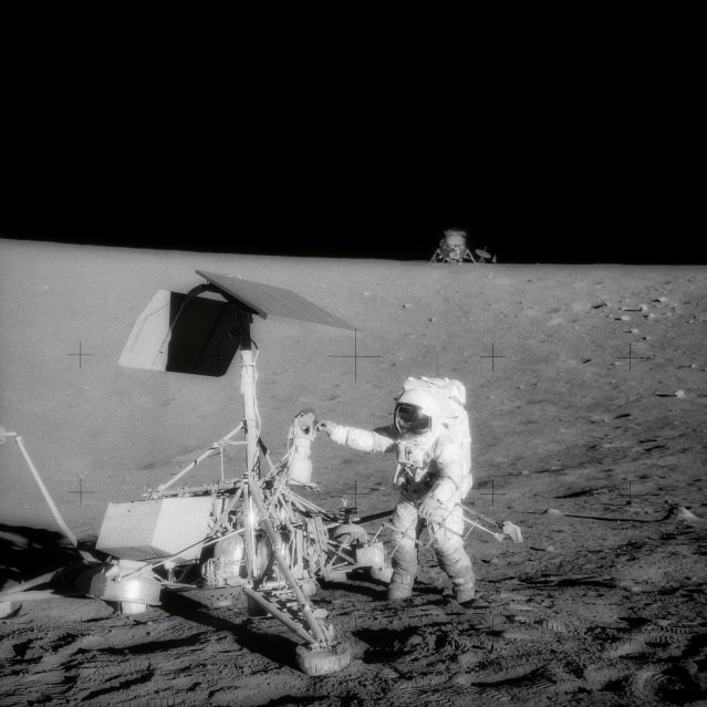
NASA recently celebrated the anniversary of the historic Apollo 12 lunar landing mission with another history making craft – the long lived Opportunity Mars rover. Opportunity traversed around and photographed ‘Intrepid’ crater on Mars in mid November 2010. The crater is informally named in honor of the ‘Intrepid’ lunar module which landed two humans on the surface of the moon on 19 November 1969, some forty one years ago.
Apollo 12 was only the second of NASA’s Apollo missions to place humans on the Earth’s moon. Apollo astronauts Pete Conrad and Gordon Bean precisely piloted their lunar landing spacecraft nicknamed ‘Intrepid’ to a safe touchdown in the ‘Ocean of Storms’, a mere 180 meters (600 feet) away from the Surveyor 3 robotic lunar probe which had already landed on the moon in April 1967. The unmanned Surveyor landers paved the way for NASA’s manned Apollo landers.
As Conrad and Bean walked on the moon and collected lunar rocks for science, the third member of the Apollo 12 crew, astronaut Dick Gordon, orbited alone in the ‘Yankee Clipper’ command module and collected valuable science data from overhead.
On the anniversary of the lunar landing, the rover science team decided to honor the Apollo 12 mission as Opportunity was driving east and chanced upon a field of small impact craters located in between vast Martian dune fields. Informal crater names are assigned by the team to craters spotted by Opportunity in the Meridiani Planum region based on the names of historic ships of exploration.
Opportunity rover took first panorama of Intrepid crater on Sol 2417 (Nov.11, 2010) which shows the rim of distant Endeavour crater in the background. Mosaic Credit: NASA/JPL/Cornell
Rover science team member James Rice, of NASA’s Goddard Space Flight Center, Greenbelt, Md., suggested using names from Apollo 12 because of the coincidental timing according to NASA. “The Apollo missions were so inspiring when I was young, I remember all the dates. When we were approaching these craters, I realized we were getting close to the Nov. 19 anniversary for Apollo 12,” Rice said. He sent Bean and Gordon photographs that Opportunity took of the two craters named for the two Apollo 12 spaceships.
Bean wrote back the following message to the Mars Exploration Rover team: “I just talked with Dick Gordon about the wonderful honor you have bestowed upon our Apollo 12 spacecraft. Forty-one years ago today, we were approaching the moon in Yankee Clipper with Intrepid in tow. We were excited to have the opportunity to perform some important exploration of a place in the universe other than planet Earth where humans had not gone before. We were anxious to give it our best effort. You and your team have that same opportunity. Give it your best effort.”
On November 4, Opportunity drove by and imaged ‘Yankee Clipper’ crater. After driving several more days she reached ‘Intrepid’ on November 9. The rover then traversed around the crater rim and photographed the crater interior from different vantage points, collecting two panoramic views along the way.
Opportunity soon departed Intrepid on Sol 2420 (Nov. 14) to resume her multi-year trek eastwards and took a series of crater images that day – from a very different direction – which we were inspired to assemble into a panoramic mosaic (in false color) in tribute to the Apollo 12 mission (see above).
Our mosaic tribute clearly shows the rover wheel tracks as Opportunity first approached Intrepid on Nov. 9 – which is fittingly reminiscent of the Apollo 12 astronauts walking on the moon 41 years ago as they explored a lunar crater. By comparison, the arrival mosaic from Sol 2417 shows distant Endeavour crater in the background.
Intrepid crater is about 16 meters in diameter, thus similar in size to ‘Eagle’ crater inside which Opportunity first landed on 24 January 2004 after a 250 million mile ‘hole in one shot’ from Earth. Eagle was named in honor of the Apollo 11 mission.
“Intrepid is fairly eroded with sand filling the interior and ejecta blocks planed off by the saltating sand”, said Matt Golembek, Mars Exploration Program Landing Site Scientist at the Jet Propulsion Laboratory (JPL), Pasadena, Calif. Asked about the age of Intrepid crater, Golembek told me; “Based on the erosional state it is at least several million years old, but less than around 20 million years old.”
Opportunity is blazing ahead towards a huge 22 km (14 mile) wide crater named ‘Endeavour’, which shows distinct signatures of clays and past wet environments based on orbital imagery thus making the crater a compelling science target.
“Intrepid is 1.5 km from Santa Maria crater and about 7.5 km from Endeavour.”
“We should be at Santa Maria crater next week, where we will spend the holidays and conjunction. Then it will be 6 km to Endeavour,” Golembek said.
The road ahead looks to be alot friendlier to the intrepid rover. “The terrain Opportunity is on is among the smoothest and easiest to traverse since Eagle and Endurance. Should be smooth sailing to Endeavour, averaging about 100 meters per drive sol. We should easily beat MSL to the phyllosilicates,” Golembek explained.
Phyllosilicates are clay minerals that form under wet, warm, non-acidic conditions. They have never before been studied on the Martian surface.
MSL is the Mars Science Lab, NASA’s next Mars lander mission and which is scheduled to blast off towards the end of 2011. Golembek leads the landing site selection team.
The amazing Opportunity rover has spent nearly seven years roving the Martian surface, conducting a crater tour during her very unexpectedly long journey at ‘Meridiani Planum’ on Mars which now exceeds 26 km (16 miles). The rovers were designed with a prime mission “warranty” of just 90 Martian days – or sols – and have vastly exceeded their creators expectations.
“What a ride. This still does not seem real,” Rob Manning told me. Manning headed the Entry, Descent and Landing team at JPL for both the Spirit and Opportunity rovers. “That would be fantastic if Opportunity could get to the phyllosilicates before MSL launches.”
Stay tuned.
This map of the region around NASA's Mars Exploration Rover Opportunity shows the relative locations of several craters and the rover location in May 2010. Credit: NASA/JPL-Caltech/Malin Space Science Systems/WUSTLAS12-48-7133 (20 Nov. 1969) --- This unusual photograph, taken during the second Apollo 12 extravehicular activity (EVA), shows two U.S. spacecraft on the surface of the moon. The Apollo 12 Lunar Module (LM) is in the background. The unmanned Surveyor 3 spacecraft is in the foreground. The Apollo 12 LM, with astronauts Charles Conrad Jr. and Alan L. Bean aboard, landed about 600 feet from Surveyor 3 in the Ocean of Storms. The television camera and several other pieces were taken from Surveyor 3 and brought back to Earth for scientific examination. Here, Conrad examines the Surveyor's TV camera prior to detaching it. Astronaut Richard F. Gordon Jr. remained with the Apollo 12 Command and Service Modules (CSM) in lunar orbit while Conrad and Bean descended in the LM to explore the moon. Surveyor 3 soft-landed on the moon on April 19, 1967.
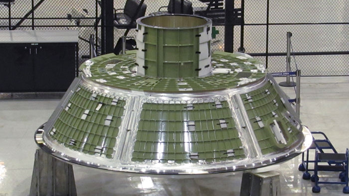
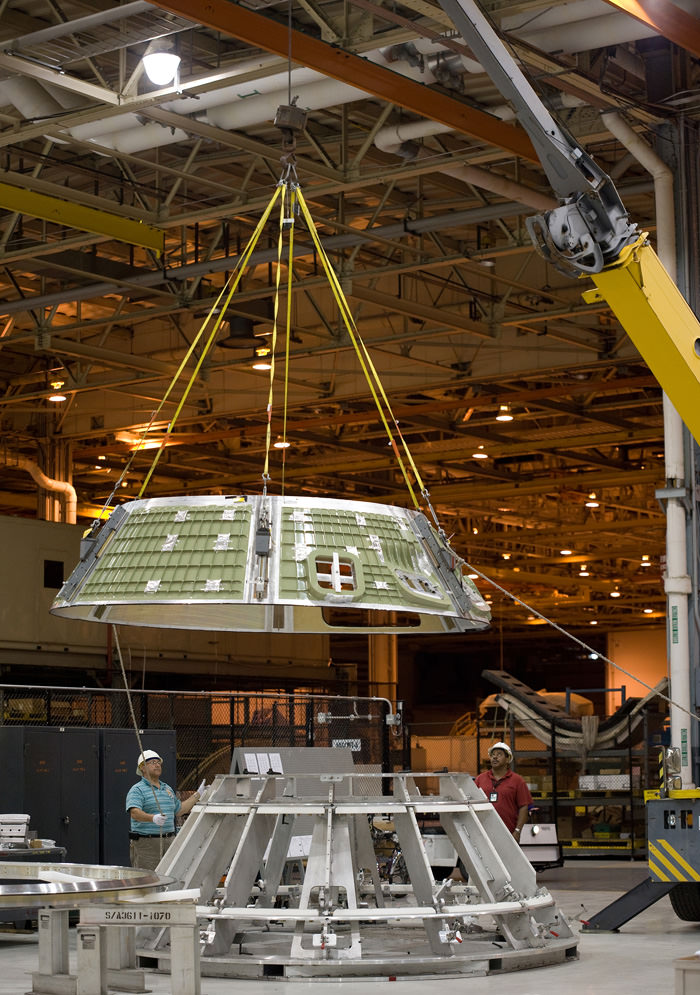
The first mated Forward Assembly of an Orion Crew Module has been built by Lockheed Martin team at NASA Michoud Assembly Facility by welding together the Cone Assembly and the Crew Tunnel segments during May 2010. The final weld for the Ground Test Article (GTA) will join this Forward Assembly to the Aft Assembly. An aeroshell covered with thermal protection tiles will be attached later after the GTA skeleton is completed and mass simulators have been installed inside. Astronauts would enter the International Space Station through the tunnel after docking. Credit: Lockheed Martin
“The Orion capsule is the Congressionally approved program of record and we are moving forward with it”, says Larry Price, Lockheed’s Orion Deputy Program Manager in an interview with me. “Our work is continuing with the funding which is still approved until September 2010. Orion is a very functional vehicle. All subsystems will be state of the art.
“Orion is not Apollo on Steroids”, Price emphasized.
“We are building on what is known and it’s a very contemporary approach. The flight avionics are very similar to commercial airliners. We can take advantage of the latest advances in avionics and computing. Orion has been designed for long duration interplanetary functionality to operate beyond Low Earth Orbit (LEO) for 6 months or more to visit the Moon, Asteroids, Lagrange points and other targets of interest for scientific investigation”, Price explained.
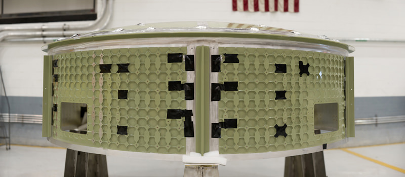
The Orion Cone assembly for the GTA is shown here with “Confidence panels” and equipment slings and clamps which were used to “practice“ and validate the crucial friction stir welding procedures for welding together the hardware segments which form the first Orion GTA pathfinder vehicle. Credit: Lockheed Martin
“The Orion project status is we have just one more weld remaining on the crew cabin”, says Tim Knowles. He is the Orion GTA Vehicle manager for Lockheed Martin and discussed Orion development in an interview with me. “When all follow on work to prepare the GTA is done, the final Orion GTA crew cabin will look very much like a real Orion capsule,” Knowles said.
“The final close out weld will join the Forward Cone Assembly and Crew Tunnel to the barrel shaped Aft Assembly. This combined piece then comprises the habitable volume and forms the first structural framework for the first Orion Crew Cabin”.
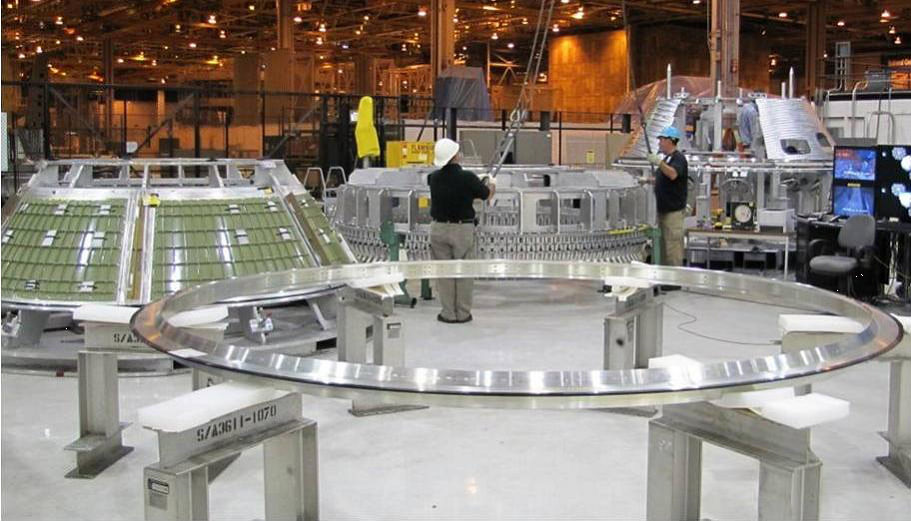
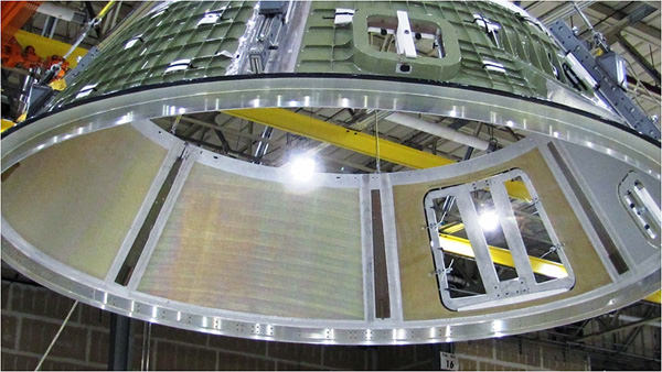
Interior view of Cone Assembly and crew hatch welded to the mid-ring (silver colored) at base. The 5 meter diameter Cone Assembly weighs about 650 lbs and will be welded to the Aft Assembly. The 18 cm thick mid-ring joins the barrel of the Aft Assembly to the Cone. The bent “T” shaped ring adds stiffness to the structure and also provides an attach point for the aeroshell support structure. Credit: Lockheed Martin“Inside the Aft Assembly is the backbone skeleton which provides structural stiffness to the cabin and also hardware mounting locations. The Aft Assembly is where the crew seats, storage lockers and other systems are installed onto compartments inside the backbone skeleton”.
“The welding process uses a technique called Friction Stir Welding (FSW)”, Knowles said. “It has produced acceptable results so far. It’s a learning process and not flawless, and improves each time we do it” added Knowles.
Orion Crew Module Cone for the Ground Test Article is hoisted and moved in preparation for welding at the NASA Michoud Assembly Facility in New Orleans, La. Credit: Lockheed MartinThe welds for the final large segments ranged from about 300 to 450 inches in length. “These are the longest FSW welds ever attempted”, according to Larry Price.
“We use sound to evaluate the work and detect any flaws”, explained Knowles. “The testing method is called Phased Array Ultrasonic Testing (PAUT). It’s a Non-Destruction Evaluation (NDE) technique. Remember, the GTA is intended as a manufacturing pathfinder as well as a structural test article”.
“The actual welding times to combine the individual segments requires only about 45 minutes to an hour. Of course the real trick to getting a good weld is that it takes many many days of preparation work to get the parts and equipment and everything else set up properly,” explained Knowles.
Orion Aft Assembly, with Barrel and Bulkhead, will house the Backbone Assembly and be welded to the Forward Cone/Tunnel Assembly to form the complete Orion GTA structural assembly Credit: Lockheed Martin
“Most of the work on the parts needed to complete the GTA after completion of the welding is well along. They will be installed inside following a pressure test of the crew cabin that is scheduled for June. These include mass and volume simulators for items like the crew seats and consoles, lockers, waste management etc. On the outside we’ll add simulators for the parachutes, compressed gases, propellants and thrusters all around the shell we welded together”.
“Then we’ll add the simulated [cone shaped] thermal protection system (TPS) aeroshell around that, including a few real TPS tiles. We will also add a heat shield.”
“When we are done adding everything, the final Orion GTA will look very much like a real flight article of the Orion capsule”.
Mock up of the Orion Capsule at the Kennedy Space Center Visitor Center. 4300 people are working on the Orion project across the US. Credit: Ken Kremer
“The GTA will then be placed in a chamber and bombarded with acoustic energy for environmental correlation tests. These tests simulate the flight environment to collect data for the purpose of comparing the results to our predictive models, updating the models, and then refining the design of the crew cabin”.
“We are planning to ship the GTA to our Lockheed facility in Denver around the end of October. It will be integrated with a simulated Launch Abort System to form a launch abort vehicle (LAV) that will subjected to further vibro-acoustic tests next spring. Then the GTA crew module will be shipped to NASA Langley for water drop landing testing to simulate the impact. Those tests will run into 2012”.
“About 86 people are currently working on various aspects of the Orion GTA project at Michoud”, according to Lockheed spokesman Kevin Barre.
The GTA is a key pathfinder vehicle and the first full-sized, flight-like test article for Orion. It will be subjected to numerous stringent tests which are crucial learning exercises that will help validate the cabin design and will be used to incorporate changes to the tools and manufacturing processes that will eventually lead to a human rated production vehicle.
This Orion GTA capsule is an indispensible forerunner to the next generation Orion vehicle which NASA had planned for human flights to shot to the Moon and the International Space Station (ISS). It is not an unmanned “rescue capsule”, or lifeboat, as recently proposed by President Obama at his April 15 space policy speech at the Kennedy Space Center (KSC).
President Obama’s new announcement to resuscitate Orion as a “rescue capsule” was a significant refinement to his original plan of February 2010 to wholly terminate Orion and Project Constellation as part of his initial 2011 NASA Budget proposal which would radically alter the future path of NASA.
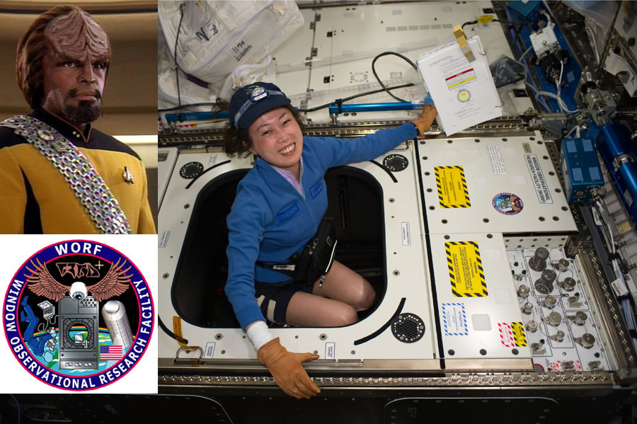
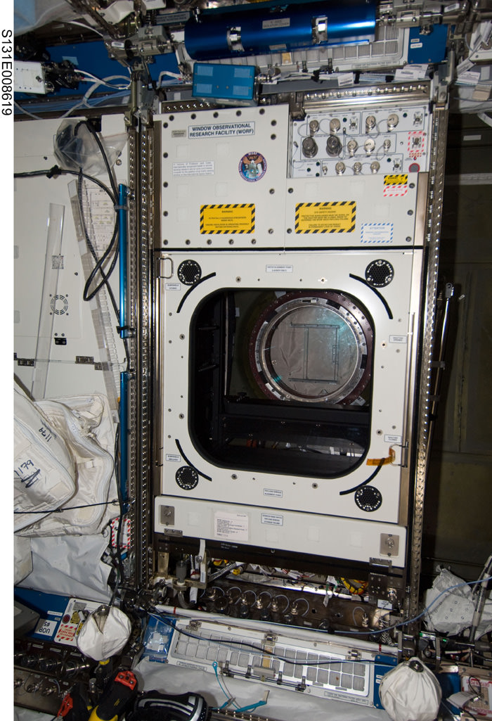
Japan Aerospace Exploration Agency (JAXA) astronaut Naoko Yamazaki, STS-131 mission specialist, works inside the Window Observational Research Facility (WORF) in the Destiny laboratory of the International Space Station while shuttle Discovery was still docked. WORF is a platform for cameras, multispectral scanners, and other sensors to capture science imagery of Earth imagery through Destiny's earth facing window. WORF is named after the Klingon character Worf beloved in the Star Trek Universe (top left). The WORF patch (lower left) is inscribed with Commander Worf’s name in Klingon script and was created by Tony Boatright. Credit: NASA images. WORF Patch: NASA/Tony Boatright. Mosaic: Ken Kremer
[/caption]
WORF has finally joined the crew aboard the International Space Station (ISS). That’s great news for NASA as well as members and fans of the Klingon High Council who are delighted to occupy a prime location for exquisite surveillance of the Earth and Federation activities.
WORF is the acronym for the Window Observational Research Facility, a new science imaging platform on the ISS, which is named after the popular Klingon character from the “Star Trek: The Next Generation” science fiction television series. The surface panel on WORF sports a beautiful patch with a Klingon language inscription – spelling out the name WORF in Klingon script (see photo). Although seemingly innocent, Universe Today has learned that the Klingon High Council may have more sinister plans afoot for WORF involving future imperial undertakings.
WORF was designed by Earthlings to function as a photographic darkroom for precision remote space sensing of the Earth. As such, it’s also the only rack on the station that ISS astronauts and cosmonauts can actually physically float into and then maneuver equipment around to conduct their science research. “The working volume to accommodate instruments is about 23 cubic ft (0.8 cubic m)”, according to Dennis Toney of Boeing, Huntsville, Al, who I interviewed at the Kennedy Space Center during the STS 131 launch.
Panels, shelving and brackets inside WORF provide numerous attach points for digital cameras, multispectral and hyperspectral scanners, camcorders, sensors and other instruments to capture Earth imagery through Destiny’s nadir – Earth facing – window.
The experiments will focus on studies of atmospheric and climate properties, land and sea formations, geology, agriculture, ranching, environmental and coastal changes, and also be linked to public outreach and education efforts.
“EarthKAM is an example of a remotely controlled digital camera system that will be commanded to take pictures by middle school students across the US using web based tools”, Toney explained to me. The kids will learn how to work as real scientists. See WORF graphics provided to the author by Boeing/Denis Toney.
Graphics show WORF ‘darkroom’ science rack loaded with cameras and spectral payloads (left) and after closing with hatch (right) to exclude stray light from entering the payload volume. Crewmembers control the experiments loaded inside WORF using a laptop computer mounted on the front of the rack. NASA will use WORF for high resolution Earth observation experiments. Middle school students will be able to remotely control the EarthKAM digital camera payload inside WORF to take photos of the earth and learn how to work as real scientists. Graphics courtesy of Boeing/Dennis Toney were specially provided to the author for this story.
Astronauts installed the WORF darkroom inside the US Destiny Laboratory module and purposely “placed it in a bay directly over the labs 20 inch (508 mm) diameter observation window to provide direct access to the window from inside WORF”, said Toney.
“WORF provides the infrastructure to maximize the usability of the window. Up to 5 science payloads can be accommodated at once”, explained Toney. Numerous instrument connector ports and jacks for Ethernet computer connections, power, video and cooling are built directly into the rack to transmit the multispectral and high resolution experimental imaging data to the ground.
The Destiny window is the highest quality optical glass science window ever flown on any manned spacecraft. The window is constructed from 4 panes of optical quality glass pressed together that permit greater than 95% transmission across most of the visible spectrum and 90% transmission in the near infrared.
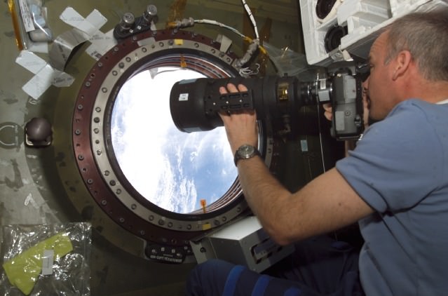
Jeff Williams, Expedition 13 Science Officer, at the U.S. Destiny Laboratory Science Window on the ISS. Williams recently served as the ISS Expedition 22 Commander.WORF was mounted on top of the Destiny window by the STS 131 crew.
The photographic and spectral gear – up to 350 mm aperture – mounted inside WORF can be remotely operated from Earth or by astronauts on board, who may also work in a hand held mode as required by the particular piece of equipment to maximize the scientific return.
An external shutter protects the window from micrometeoroid and orbital debris floating outside the station. The hinged cover can be manually opened and closed by the crew inside the cabin with a hand crank.
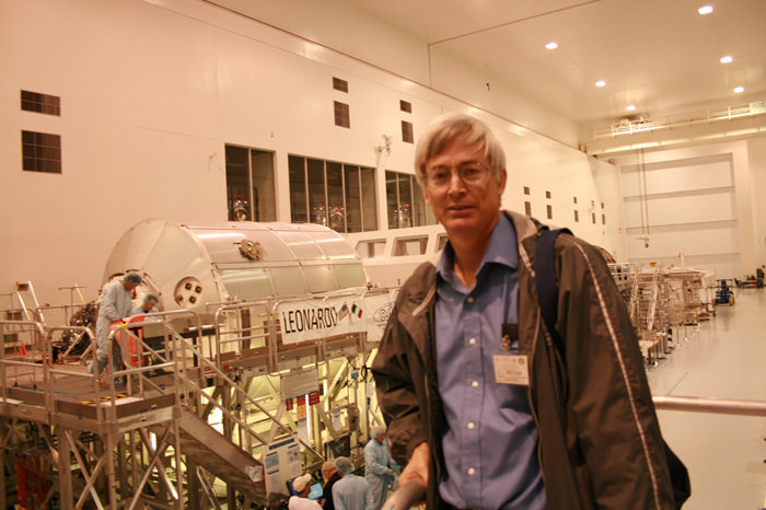
The “Leonardo’ Multi-purpose Logistics Module (MPLM) weighs over 27,000 pounds and is one of three such modules built by the Italian Space Agency. The module serves as a space moving van and was loaded with 16 science and storage racks – including WORF – holding over 17,000 pounds of science supplies and experiments, crew life support provisions, spare parts, a new astronaut sleep quarter and a minus 80 degree freezer to stow science samples collected by the resident ISS crew.
The Leonardo resupply module and Ken Kremer inside the Space Station Processing Facility at the Kennedy Space Center as the module was being prepared for launch aboard shuttle Discovery on the STS 131 mission. WORF science rack and over 17,000 pounds of science equipment and supplies were loaded inside Leonardo. Credit: Ken Kremer
After Discovery docked to the ISS, Leonardo was hoisted out of Discovery’s cargo bay and berthed to the station for the duration of the flight. The massive orbiting outpost is 98% complete – by habitable volume – and weighs in at 800,000 pounds and spans the length of an American football field.
Space Shuttle Discovery undocked from the ISS on Saturday morning (April 17) in preparation for a Monday April 19 landing at 8:51 AM. Credit: NASAThe STS 131 mission of Space Shuttle Discovery is nearing a close. Discovery undocked from the ISS early this morning at 8:52 AM and about 213 miles above earth and is set to land at KSC on Monday morning at 8:51 AM, weather permitting.
Authors Note: This paragraph is just for fun excepting Federation Counterintelligence agents. Unbeknownst to the crew members and NASA, top secret Klingon military surveillance technology was embedded deep within the WORF unit, according to a source who requested anonymity. Whilst the STS 131 crew was innocently hooking up umbilical line connections to the ISS electrical and computer systems, they unwittingly activated the Klingon Empires cloaking chip previously hidden inside WORF by time traveling Klingon spies dispatched by the High Council. The chip instantaneously began transmitting encoded data via sub space frequencies to eagerly waiting intelligence operatives working for the Klingon Chancellor. Stay tuned for more on WORF and the Klingon infiltration of the ISS.
Dennis Toney (Boeing) and Ken Kremer discuss the science goals of the WORF facility at the Kennedy Space Center Press Site during the STS 131 launch of shuttle Discovery on April 5, 2010. Discovery delivered WORF to the ISS. Credit: Ken Kremer
What role will NASA play in the future of US manned space flight after the shuttle is retired at the height of its capability ?
[/caption]A few details have finally emerged about Presidents Obama’s short visit to the Kennedy Space Center on April 15 to discuss his new plans for NASA as part of his 2011 NASA Budget Request to Congress. Obama’s visit to KSC will begin at 1:30 PM and end at 3:45 PM, when he departs for a longer visit to a political fundraiser. Check this story from the Miami Herald about the fundraiser.
In February 2010 President Obama announced the complete termination of Project Constellation including the Ares 1 and Ares 5 booster rockets and the Orion Manned Capsule. Project Constellation was proposed by President Bush in 2004 with a new vision to return humans to the moon by 2020 and then Mars thereafter.
Instead, Obama proposes to rely on commercial providers to develop ‘space taxis’ to ferry US astronauts to low earth orbit and the International Space Station. No one can say with any certainty when these vehicles will be available.
President Obama has not announced any specific plans, targets, destinations or timelines for NASA to replace those cancelled as part of Constellation. There are no current plans to develop a Heavy Lift booster. there are only funds for technology development.
There has been harsh criticism of the Presidents new plans for NASA from both Democrats and Republicans who see a loss of US Leadership in Space. Even Sen. Bill Nelson (D) of Florida says “President Obama made a mistake [cancelling Constellation]. Because that is the perception. That he killed the space program.”
This visit was initially dubbed a “Space Summit” by the White House, but will now span barely 2 hours in length (including travel time between KSC venues) and apparently not involve significant interaction with or questions from the many thousands of space workers who are about to lose their jobs.
The format of the visit has also been changed from a sort of town hall meeting to a formal address by President Obama to a selected audience of about 200. His remarks will be followed by brief breakout sessions on a few space topics to implement the new directives given to NASA by the White House.
Here is a portion of the Statement from the White House dealing with the President’s Remarks:
THE WHITE HOUSE April 12, 2010
Office of Media Affairs MEDIA ADVISORY: M10-054
PRESIDENT OBAMA TO DELIVER REMARKS AT KENNEDY SPACE CENTER
WASHINGTON – On the afternoon of Thursday, April 15 President Barack Obama will visit Cape Canaveral, Florida and deliver remarks on the bold new course the Administration is charting for NASA and the future of U.S. leadership in human space flight.
Both the arrival and departure of Air Force One at the Shuttle Landing Facility and his remarks at the NASA Operations and Checkout Building are open to the media.
Air Force One Scheduled Arrival: 1:30 PM
Air Force One Scheduled Departure: 3:45 PM
President Obama Remarks at Kennedy Space Center
NASA Operations and Checkout Building
The opening session, including the President’s remarks, and the closing session of the conference are open to pre-credentialed media. The breakout sessions in between will be closed press and streamed at http://www.nasa.gov/ntv.
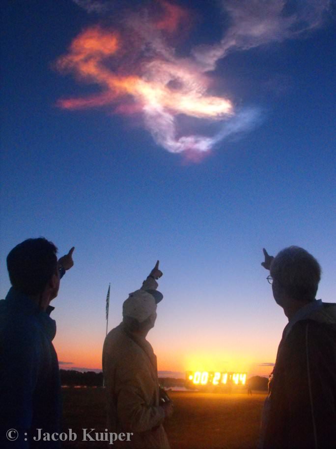
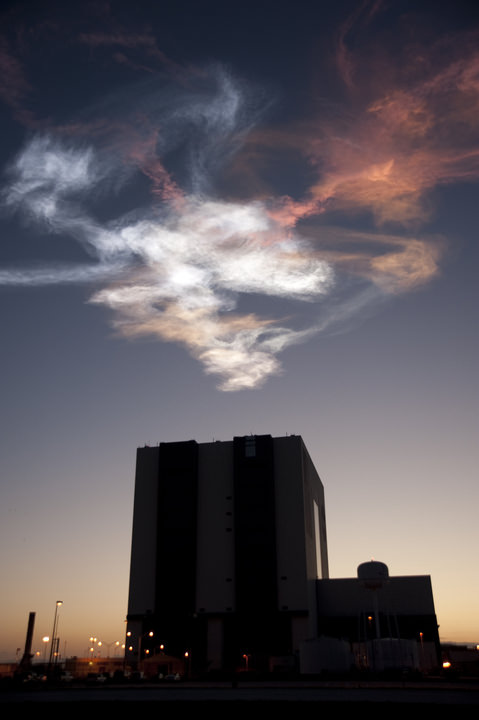
‘Mother of Pearl’ Colored Clouds form above the Countdown clock at the Kennedy Space Center Press Site about 23 minutes after the April 5, 2010 launch of Space Shuttle Discovery, as 3 excited Science Journalists point out (from left, Rob van Mackelenbergh, Jacob Kuiper and Ken Kremer). Credit: Jacob Kuiper
[/caption]
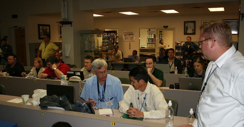
(Editor’s Note: Ken Kremer is at the Kennedy Space Center for Universe Today covering the flight of Discovery)
Well I’ve never witnessed anything like the magnificently colored clouds following Monday’s (April 5) predawn launch of Shuttle Discovery. They are known as “Mother of Pearl” clouds – according to Jacob Kuiper, Senior Meteorologist with the Royal Netherlands Meteorological Institute (KNMI).
Kuiper and myself observed the launch together with journalist Rob van Mackelenbergh (Dutch Society for Spaceflight, NVR) at the Kennedy Space Center (KSC) Press Site, located across the street from the iconic Vehicle Assembly Building where Shuttle’s are prepared for launch. See our STS 131 Launch day photo mosaic below of the day’s thrilling events.
At first the wispy clouds were nearly all white and set against the still dark sky. Then the sky overhead was suddenly lit on fire with a growing multitude of these pastel colored “Mother of Pearl” clouds – also called “Nacreous” clouds.
“The Mother of Pearl Clouds began turning from white to hues of pink and yellow. Starting about 10 minutes after the launch of Space Shuttle Discovery, its exhaust plume turned into a magnificently colorful panorama. Generally, this continues until about 40 minutes or more after blast off”, Kuiper told me as we stood next to the world famous Countdown clock and gazed in awe at the colored clouds above.
STS 131 Launch Day Mosaic: Crew walkout to Astro Van and ride to launch pad; Discovery Blast off and Countdown Clock at KSC Press site at T Plus 4 Seconds; Pastel Colored ‘Mother of Pearl’ Clouds which formed above the Countdown Clock at T Plus 23 Minutes as three science journalists are in awe. Click to Enlarge. Credit: Rob van Mackelenbergh, Ken Kremer and Jacob Kuiper
“Launching northeast in the predawn sky here on the ground means as the shuttle and its exhaust plumes head to orbit they’re going to catch the rising sunlight and that’s what creates the spectacular clouds we saw on launch morning !” KSC spokesman Allard Beutel explained to me.
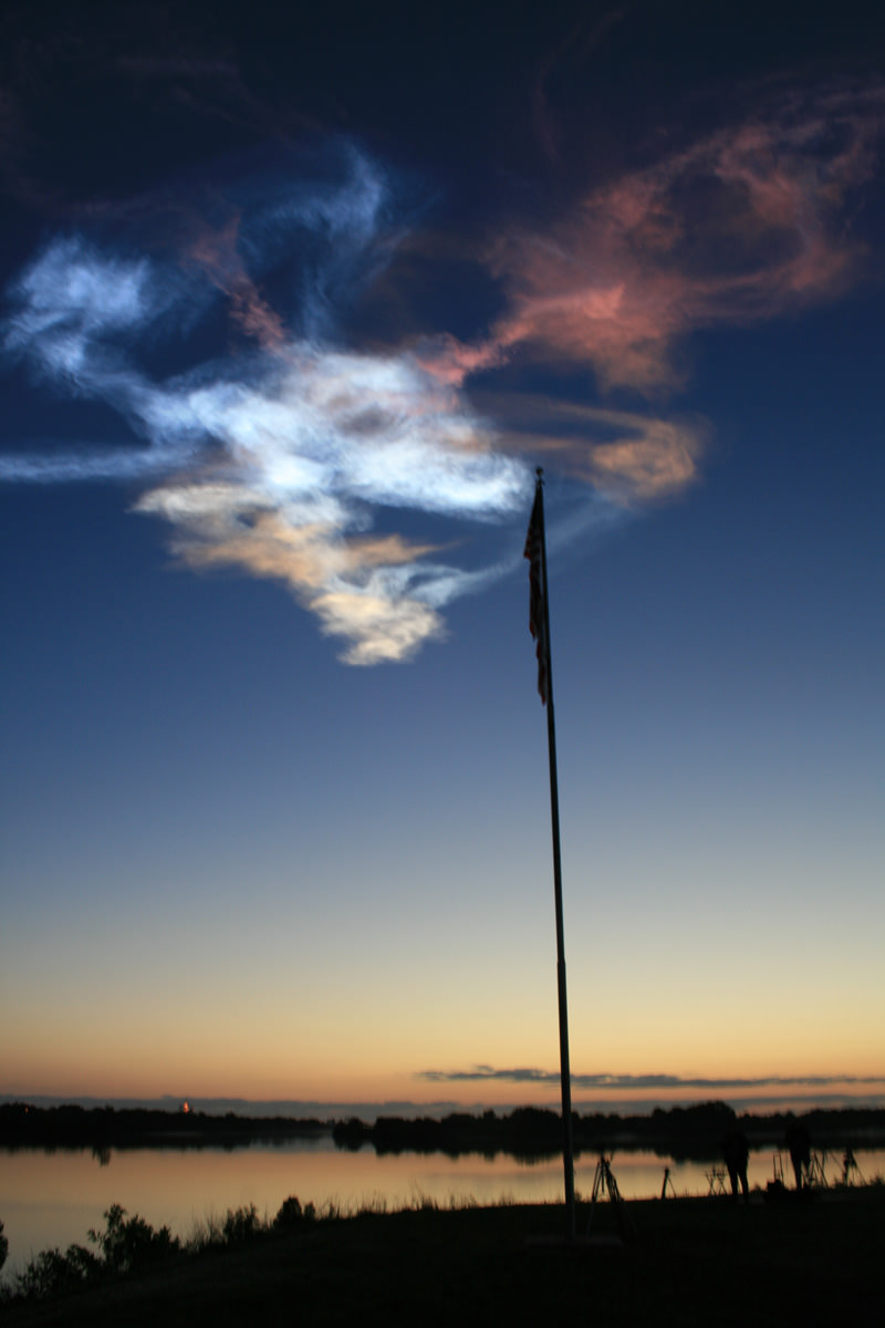
Mother of Pearl Clouds form above US Flag at Kennedy Space Center from STS 131 Launch Exhaust Plume. Credit: Ken KremerThe wispy clouds are transient events – constantly evolving in mere seconds as they are blown in a multitude of directions. Indeed it’s quite easy to let your imagination run wild and dream all sorts of fantastical things ranging from mythical creatures to assorted life forms and even people. Certainly someone has sighted Elvis in the rocket plumes.
“Atmospheric layers between 15 and 85 kilometers height normally contain very low quantities of water vapor. But the final exhaust product of the Shuttle’s external tank (hydrogen and oxygen) provides an enormous amount of water vapor”, Kuiper said.
“In the very cold atmosphere layers, the vapor turned into a tremendous mass of ice crystals and tiny super cooled water droplets. These crystals reflect and bend the solar rays very efficiently and create a nice spectrum of colors”.
“The lowest clouds, turned pink and orange, because at that height the sun just rises and most rays are a bit more reddish due to a certain extinction of the atmosphere. The higher portions of the exhaust plume hardly experience any extinction,” Kuiper explained.
“In layers around the Mesopause (about 85 km), clouds sometimes appear in the weeks around June 21 (northerly latitudes). These clouds are called Noctilucent clouds – or NLC. Both types can be produced due to the exhaust plumes from a Space Shuttle launch”, said Kuiper.
By far the largest and most long lasting rocket exhaust clouds derive from the Space Shuttle because it’s the most powerful rocket in the US Fleet – although not for much longer after the shuttle is retired and the US completely loses its Heavy Lift boost capability.
STS 131 Launch Contrails over the Kennedy Space Center on 5 April 2010. Credit: John O’Connor
Flock of Birds fly in front of Pastel colored clouds which formed above Kennedy Space Center from STS 131 Launch Exhaust Plume. Credit: Ken Kremer Wispy contrails from the launch of space shuttle Discovery on the STS-131 mission glow in rainbow colors in the early morning hours as the sun rises over the Vehicle Assembly Building at NASA's Kennedy Space Center in Florida. Shuttle Discovery lifted off at 6:21 a.m. EDT on April 5, 2010. Credit: NASA/Kim Shiflett
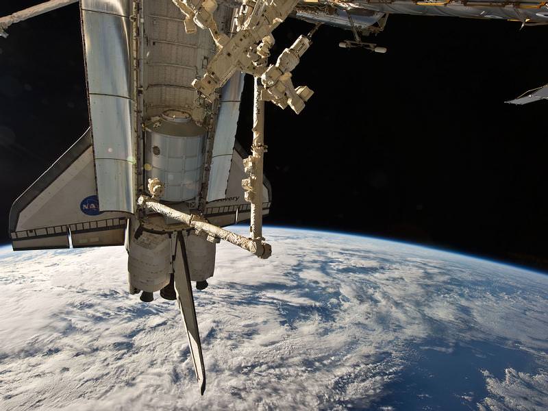
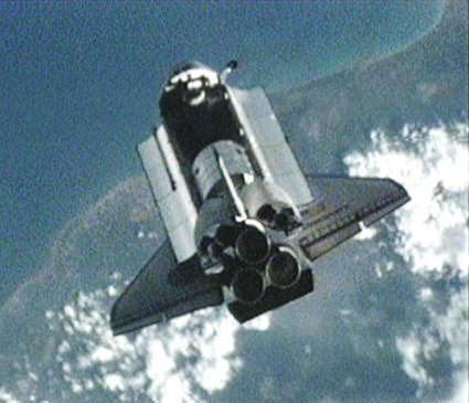
Space shuttle Discovery comes out of its 8 minute long back flip maneuver underneath the International Space Station as ISS astronauts collect high resolution photos of the heat shield for analysis to confirm it is intact and safe to land. Credit: NASA TV
Hatches between Discovery and the ISS were opened at 5:11 AM EDT this morning, bringing together the seven-person shuttle crew and the six-person space station crew, to begin nine days of joint work and operations. The primary goal of the STS 131 mission is to outfit the station with numerous new science experiments, install a new crew sleeping quarter and to resupply stocks of essential parts and provisions.
[/caption]Discovery’s cargo bay is packed with the 27,000 pound Leonardo Multi Purpose Logistics module built by the Italian Space Agency and a nearly 4,000 pound ammonia cooling tank.
The joint crew of 13 people marks several notable historic firsts in space exploration, including the largest ever gathering of female astronauts and Japanese astronauts in space.
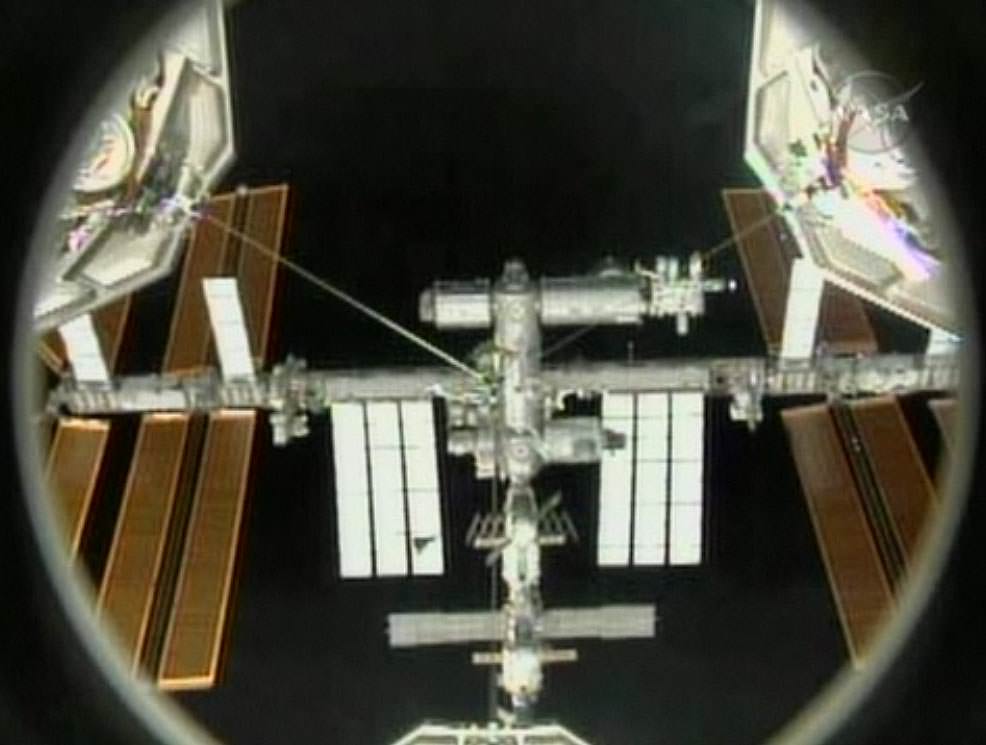
This NASA image was taken by the centerline camera inside Discovery’s docking port as she initiates final approach to the International Space Station shortly before docking at 3:44 AM on April 7, 2010 during the STS-131 mission. Credit: NASA TV
Expedition 23 Flight Engineer Soichi Noguchi and Mission Specialist Yamazaki are the first JAXA Astronauts to fly in space at the same time. A horde of Japanese media and officials were on hand at KSC to witness the launch of Discovery. This space first is a source of great pride in Japan.
The STS 131 astronaut crew led by Shuttle Commander Alan Poindexter had to rely on back up navigation systems to precisely track the station and guide Discovery to a position in front of the ISS and then gently dock at the Harmony module (Node 2). The crew are trained to rendezvous and dock without radar.
Station Commander Oleg Kotev and NASA astronaut TJ Creamer took high resolution images of Discovery’s heat shield during the 8 minute back flip maneuver to document the condition and integrity of the many thousands of critical thermal protection tiles fastened to the belly, wing leading edges and nose cap of Discovery.
The pair snapped hundreds of photos using 400 mm and 800 mm cameras through portholes from their location inside the Russian Zvezda Service Module. These photos will be thoroughly scrutinized by imagery experts back at Mission Control in Houston to look for any signs of damage to the heat shield before NASA commits Discovery to the scorching heat of reentry and a return landing back on Earth.