Dr. Ken Kremer is a speaker, research scientist, freelance science journalist (KSC area,FL) and photographer whose articles, space exploration images and Mars mosaics have appeared in magazines, books, websites and calendars including Astronomy Picture of the Day, NBC, FOX, BBC, SPACE.com, Spaceflight Now, Science and the covers of Aviation Week & Space Technology, Spaceflight and the Explorers Club magazines. Ken has presented at numerous educational institutions, civic & religious organizations, museums and astronomy clubs. Ken has reported first hand from the Kennedy Space Center, Cape Canaveral, NASA Wallops, NASA Michoud/Stennis/Langley and on over 80 launches including 8 shuttle launches. He lectures on both Human and Robotic spaceflight - www.kenkremer.com. Follow Ken on Facebook and Twitter
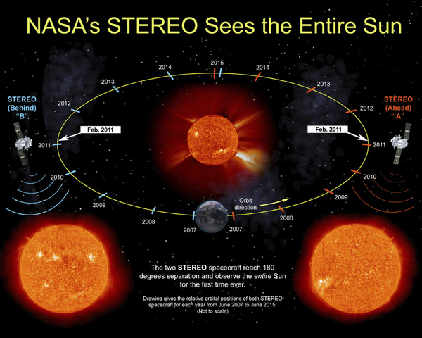
On Super Bowl SUNday - Feb 6, 2011; the two NASA STEREO spacecraft willl see the entire Sun ! Superbowl SUNday will truly mark a milestone for solar observations. On Ferbruary 6, the two STEREO spacecrafts will be 180 degrees apart and for the next 8 years the STEREO spacecrafts and SDO will be able to observe the entire 360 degrees of the Sun. Credit: NASA. Watch the cool STEREO Whole Sun Preview Video below. Plus Launch Video and more photos below.
“For the first time in the history of humankind we will be able to see the front and the far side of the Sun … Simultaneously,” Madhulika Guhathakurta told Universe Today. Guhathakurta is the STEREO Program Scientist at NASA HQ.
And the noteworthy event is timed to coincide just perfectly with ‘Super Bowl SUNday’ – Exactly one week from today on Feb. 6 during Super Bowl XLV !
“This will be the first time we can see the entire Sun at one time,” said Dean Pesnell, NASA Solar Astrophysicist in an interview for Universe Today. Pesnell is the Project Scientist for NASA’s Solar Dynamics Observatory at the NASA Goddard Spaceflight Center in Greenbelt, MD.
This remarkable milestone will be achieved when NASA’s two STEREO spacecraft reach position 180 degrees separate on opposite sides of the Sun on Sunday, Feb. 6, 2011 and can observe the entire 360 degrees of the Sun.
“We are going to celebrate by having a football game that night!” Pesnell added in jest.
The nearly identical STEREO spacecraft – dubbed STEREO Ahead and STEREO Behind – are orbiting the sun and providing a more complete picture of the Suns environment with each passing day. One probe follows Earth around the sun; the other one leads the Earth.
STEREO is the acronym for Solar TErrestrial RElations Observatory. Their mission is to provide the very first, 3-D “stereo” images of the sun to study the nature of coronal mass ejections.
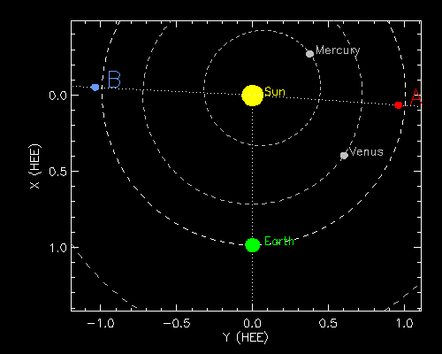
Today, (Jan 30) the twin STEREO spacecraft are 179.1 degrees apart and about 90 degrees from Earth, and thus virtually at the midpoint to the back of the sun. See the orbital location graphics above and below.
Both probes were flung into space some four years ago and have been hurtling towards this history making date and location ever since. The wedge of unseen solar territory has been declining.
As the STEREO probes continue flying around to the back side of the sun, the wedge of unseen solar territory on the near side will be increasing and the SDO solar probe will play a vital gap filling role.
“SDO provides the front side view of the sun with exquisite details and very fast time resolution,” Gutharka told me. For the next 8 years, when combined with SDO data, the full solar sphere will still be visible.
The Whole Sun will be simultaneously Imaged for the First tIme ever on Super Bowl SUNday Feb. 6.
For the past 4 years, the two STEREO spacecraft have been moving away from the Earth and gaining a more complete picture of the sun. On February 9, 2011, NASA will hold a press conference to reveal the first ever images of the entire sun and discuss the importance of seeing all of our dynamic star.
Credit: NASA
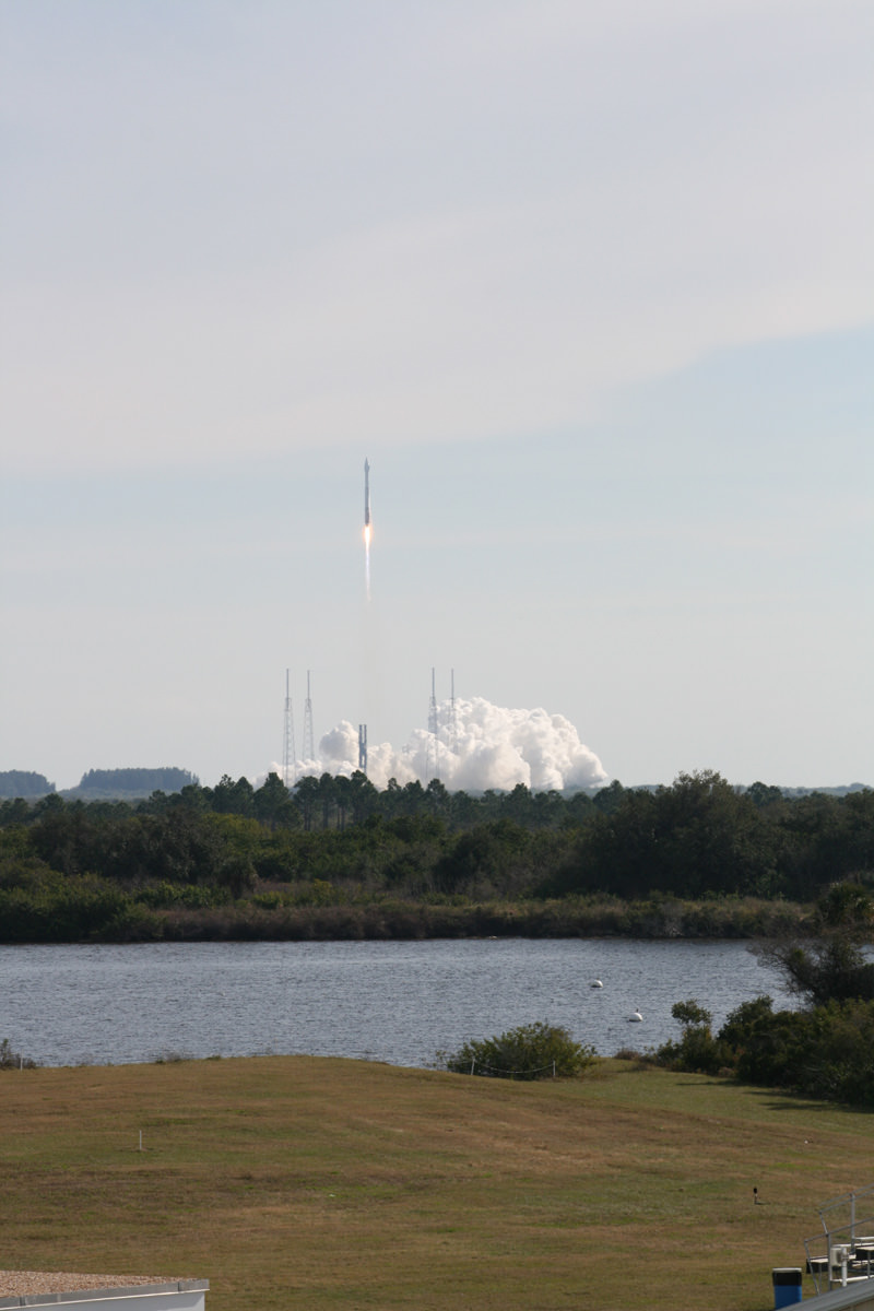
The solar probes were launched together aboard a Delta II rocket from Launch Complex 17B at Cape Canaveral Air Force Station (CCAFS) in Florida on October 25, 2006. See Launch Video and Photos below.
Whole Solar Sphere A Goldmine for Science
I asked Pesnell and Guhathakurta to explain why this first ever whole Sun view is a significant scientific milestone.
“Until now there has always been an unseen part of the Sun,” Pesnell explained. “Although that unseen part has always rotated into view within a week or two, a global model must include all of the Sun to understand where the magnetic field goes through the surface.”
“Also, from the Earth we can see only one pole of the Sun at a time, while with STEREO we can see both poles at the same time.
“The next few years of overlapping coronal images will be a goldmine of information for predicting space weather at the Earth and understanding of how the Sun works. It is like getting the GOES images of the Earth for the first time. We haven’t missed a hurricane since, and now we won’t miss an active region on the Sun,” said Pesnell.
How will the science data collected be used to understand the sun and its magnetic field?
“Coronal loops trace out the magnetic field in the corona,” Pesnell elaborated. “Understanding how that magnetic field changes requires seeing where on the surface each loop starts and stops.”
Why is it important to image the entire Sun ?
“Once images of the entire Sun are available we can model the entire magnetic field of the Sun. This has become quite important as we are using STEREO and SDO to study how the entire magnetic field of the Sun reacts to the explosions of even small flares.”
“By seeing both poles we should be able to understand why the polar magnetic field is a good predictor of solar activity,” said Pesnell.
“Seeing both sides will help scientists make more accurate maps of global coronal magnetic field and topology as well as better forecasting of active regions – areas that produce solar storms – as they rotate on to the front side. Simultaneous observations with STEREO and SDO will help us study the sun as a complete whole and greatly help in studying the magnetic connectivity on the sun and sympathetic flares, ” Guhathakurta amplified.
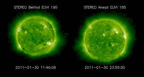
Latest EUVI Images from STEREO. These Extreme Ultra Violet Images from STEREO Ahead and Behind were taken on Jan. 30, 2011. Credit: NASA Watch a solar rotation animation here combining EUVI and SDO/AIA:
What is the role and contribution of NASA’s SDO mission and how will SDO observations be coordinated with STEREO?
“As the STEREO spacecraft drift around the Sun, SDO will fill in the gap on the near of the Sun,” explained Pesnell. “For the next 4 or more years we will watch the increase in sunspots we call Solar Cycle 24 from all sides of the Sun. SDO has made sure we are not doing calibration maneuvers for a few days around February 6.”
“On Feb 6th we will view 100% of the sun,” said Guhathakurta.
At a press conference on Feb. 9, 2011, NASA scientists will reveal something that no one has even seen – The first ever images of ‘The Entire Sun’. All 360 degrees
STEREO spacecraft location map Caption: Positions of STEREO A and B for 31-Jan-2011 05:00 UT. The STEREO spacecraft are 179.2 degrees apart and about 90 degrees from Earth on Jan. 31, 2011. This figure plots the current positions of the STEREO Ahead (red) and Behind (blue) spacecraft relative to the Sun (yellow) and Earth (green). The dotted lines show the angular displacement from the Sun. Units are in A.U. (Astronomical Units). Credit: NASA
STEREO Launch Video
Launch Video Caption: The Delta II rocket lights the evening sky as STEREO heads into space on October 25, 2006 at 8:52 p.m. The Delta II rocket lights the evening sky as STEREO heads into space. STEREO (Solar Terrestrial Relations Observatory) is a multi-year mission using two nearly identical observatories, one ahead of Earth in its orbit and the other trailing behind. The duo will provide 3-D measurements of the sun and its flow of energy, enabling scientists to study the nature of coronal mass ejections and why they happen.
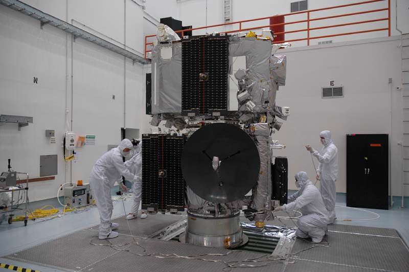
Fully fueled, technicians prepare the STEREO spacecraft for spin testing in the cleanroom in Titusville, Fl, while being prepared for launch. Credit: nasatech.net
Delta Launch Complex 17 comprises two launch pads and towers, 17 A & 17 B, at Cape Canaveral Air Force Station, FL. Credit: Ken Kremer View of Delta II Launch Complex 17 by Ken Kremer
Fully clear of the smoke, STEREO streaks skyward during launch on October 25, 2006 from Pad 17B at Cape Canaveral, FL. Credit: nasatech.net
More STEREO Cleanroom and Launch photos from nasatech.net here
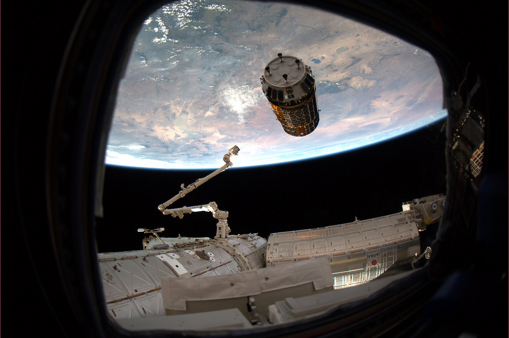
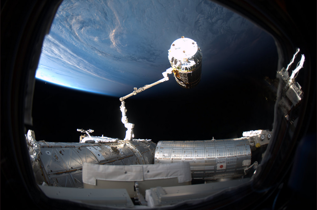
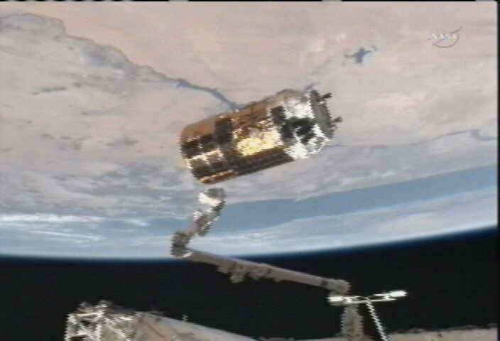
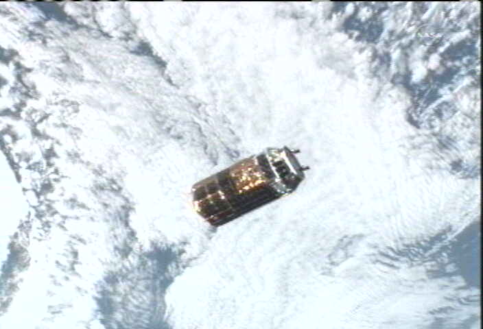
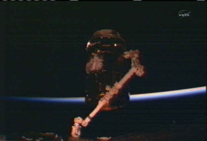
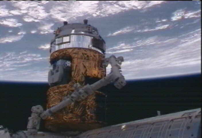
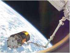
Japans Kounotori2 –or ‘White Stork’ – cargo carrier rendezvous with the International Space Station on Jan. 27, 2010. It was grappled by the ISS crew and firmly bolted to the station today. Credit: NASA/Paolo Nespoli
[/caption]
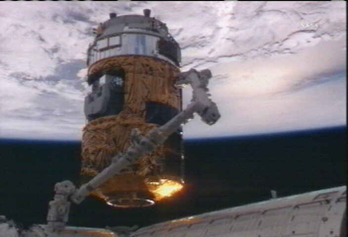
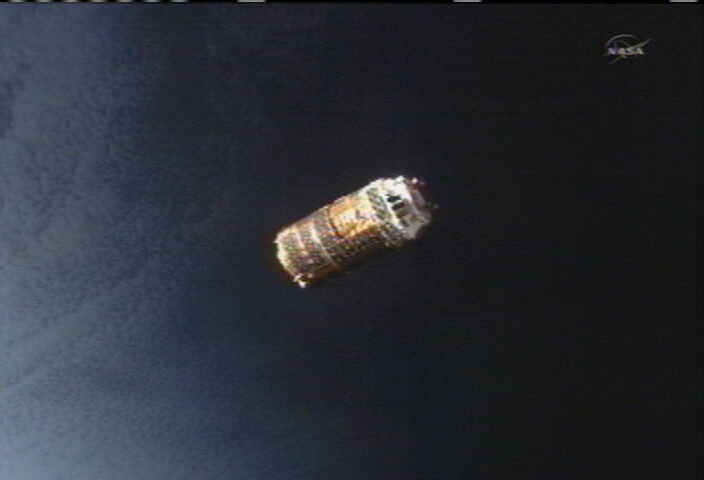
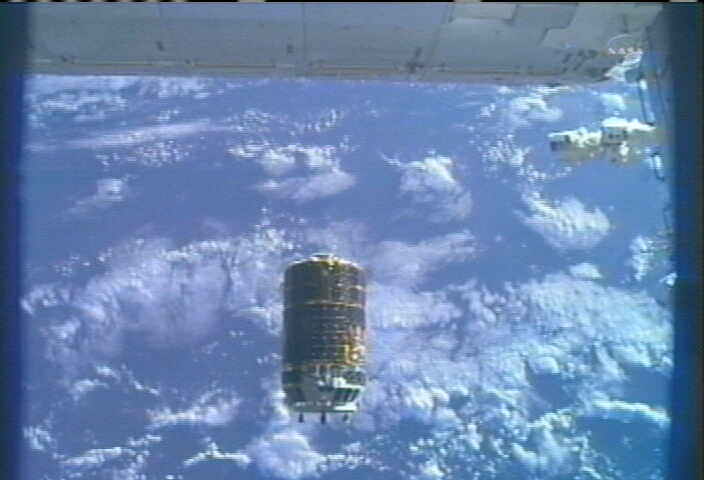
Japans critical new resupply spaceship – nicknamed Kounotori2, (HTV2) – was successfully berthed today (Jan. 27) at the International Space Station (ISS). Kounotori2 – which translates as ‘White Stork’ in Japanese – was grappled by the ISS crew and then manually nested to an Earth facing docking port on the Harmony module.
Kounotori2 was launched aboard a Japanese H-IIB rocket from the Tanegashima Space Center in southern Japan at 12:37 a.m. (2:27 p.m. Japan time) on Jan. 22 to begin a five day orbital chase of the station.
View the Video and a Photo album below of the rendezvous and docking sequence
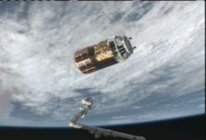
The two ships became one as Astronaut Cady Coleman grappled the free flying ‘White Stork’ at 6:41 a.m. EST with the stations robotic arm while the vessels were flying in formation about 220 miles above the south Indian Ocean in an easterly direction.
“Grapple completed, Kounotori is grappled!”
Kounotori2 was grappled by ISS crewmate Cady Coleman at 6:41 a.m. EST with the stations robotic arm while flying about 220 miles above the south Indian Ocean. ISS Tweet and Twitpic Credit: NASA/Paolo Nespoli
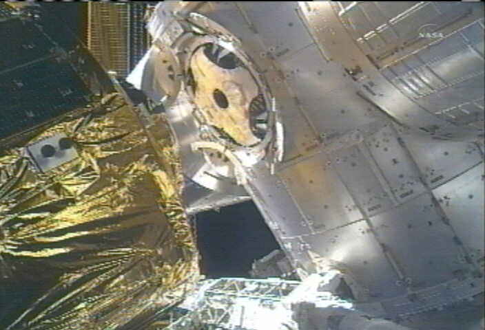
After an automatic rendezvous early this morning, the unmanned HTV2 cargo carrier slowly approached the space station from below to a series of ever closer hold points- 250 m, 30 m and 10 m.
Mission controllers on Earth carefully maneuvered the 35,000 pound ship to the final capture distance of about 33 feet (10 meters). The HTV thrusters were disabled and it was placed into ‘free drift’ mode.
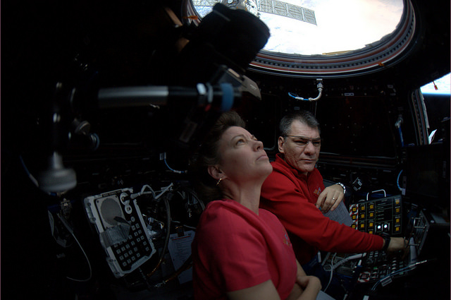
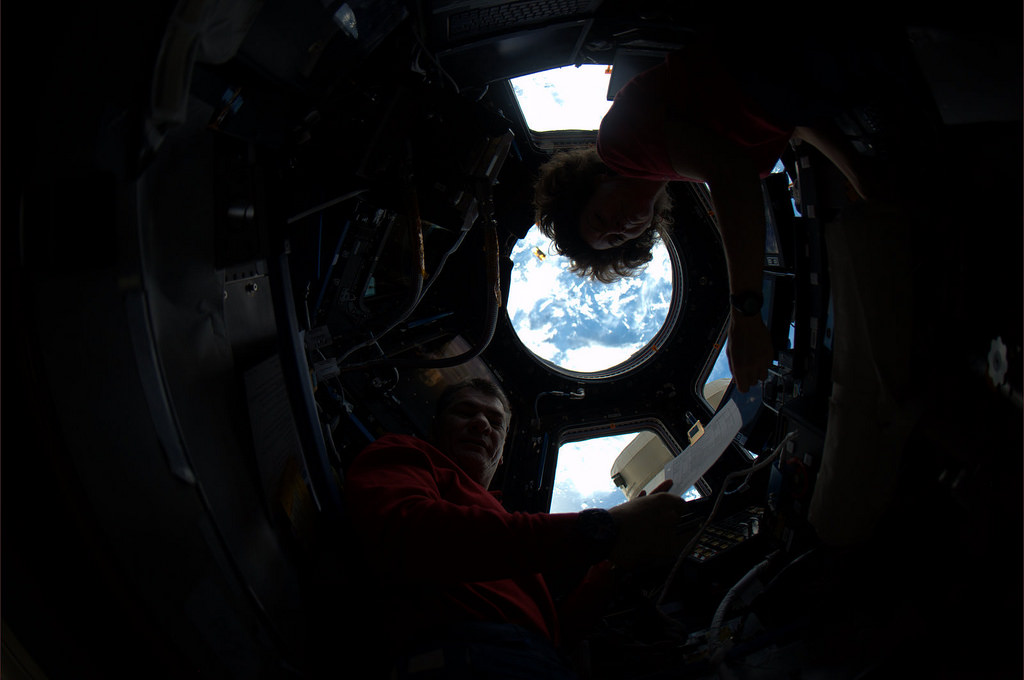
ISS astronauts Paolo Nespoli, Cady Coleman and Commander Mark Kelly crew monitored the approach from inside the ISS. The crew was deftly working at the controls of the robotics work station of the Cupola Observation dome.
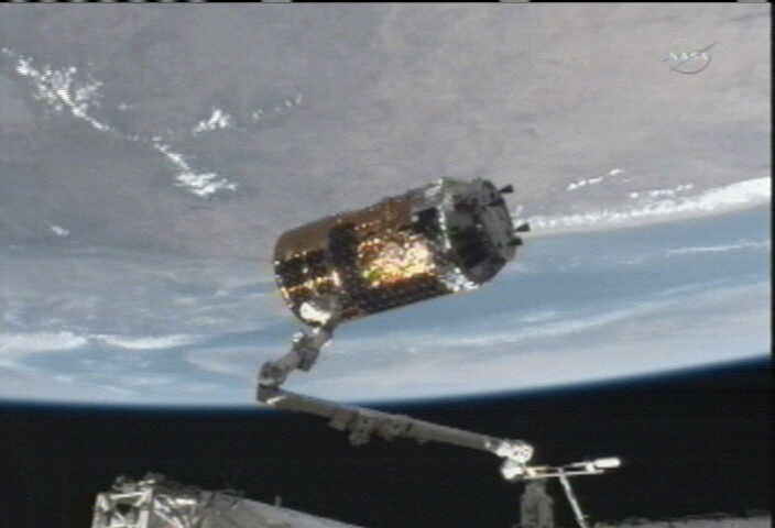
The unpiloted Japanese Kounotori2 H-II Transfer Vehicle (HTV2) is about to be attached to the Earth-facing port of the Harmony module by the station’s robotic arm. Credit: NASA TV
Finally, Coleman gently grabbed the ‘White Stork’ with the 58 foot long Space Station Robotic arm, built and contributed by Canada.
“Grapple completed, Kounotori is grappled!” tweeted and twitpiced Paolo Nespoli from the ISS.
“This demonstrates what we can do when humans and robots work together,” radioed Cady Coleman.”We look forward to bringing HTV 2 – Kounotori – aboard the International Space Station.”
Video caption: Japanese Cargo Craft Arrives at ISS.
From: NASAtelevision | January 27, 2011 An unpiloted Japanese resupply ship, the “Kounotori”2 H-2B Transfer Vehicle (HTV2 ), was captured and berthed to the Earth-facing port of the Harmony module of the International Space Station Jan. 27, 2011. The berthing took place after an automated five-day flight following its launch on the Japan Aerospace Exploration Agency’s H-2B rocket Jan. 22 from the Tanegashima Space Center in southern Japan. The ‘Kounotori’, which means “white stork” in Japanese, is loaded with more than four tons of supplies and spare parts for the six crew members on the orbital laboratory. Expedition 26 Flight Engineers Cady Coleman and Paolo Nespoli were at the controls of the robotic work station in the space station’s Cupola module to maneuver the Canadarm2 robotic arm for the grapple and berthing of the HTV2, which will remain at the orbital outpost until the end of March
Italian astronaut Paolo Nespoli had the honor of driving Kounotori2 to a hard dock at the station. The attachment was completed at 9:51 a.m. EST after Kelly inspected the docking mechanism and confirmed it was clear of debris and ready. 16 bolts firmly latched the cargo freighter into place a few hours later.
The crew will open the hatch to Kounotori2 on Friday, (Jan. 28) at about 7:30 a.m. This is only the second flight of the Kounotori. The barrel shaped vehicle is coated with 57 solar panels.
HTV-2, we are ready for you! HTV-2, siamo pronti per te! ISS Tweet and Twitpic Credit: NASA/Paolo Nespoli
Kounotori2 is loaded with over 4 tons of pressurized and unpressurized cargo, including science experiments, research gear, space parts, clothing, food and water and other provisions from Japan, NASA and Canada.
HTV2 will remain docked at the ISS for about two months until late March. During that time the ISS crew will retrieve all the equipment and supplies for transfer to locations both inside and outside the ISS.
Using the Canadian robotic arm and Dextre robot, a pallet loaded with large spare parts for the station will be extracted from a slot on the side of the cargo ship robot and attached to an experiment platform outside the Japanese Kibo module.
The White Stork “ Kounotori’ flying high above the Nile river, Egypt as it is about to be grappled by the ISS crew with the station’s robotic arm on Jan. 27, 2011. Credit: NASA TV
On Feb. 18, the ISS crew will move the HTV from the Earth facing port. They will relocate it 180 degrees to the other side of the Harmony module to the space facing zenith port. This maneuver is required to provide enough clearance for Space Shuttle Discovery so that the orbiter can also safely dock at the Harmony module in late February. Discovery is set to launch on Feb. 24.
The HTV2 docking marks the start of an extremely busy time of orbital comings and goings at the ISS.
A Russian Progress resupply ship launches later today, at 8:31 p.m. EST. Following a two day chase, the Progress will dock on Saturday night (Jan. 29) at 9:39 p.m. and deliver over 6000 pounds of cargo to the station. Watch NASA TV
The European ATV cargo ship – named ‘Johannes Kepler – blasts off on Feb. 15.
HTV2 Rendezvous & Docking Photo Album: Jan 27, 2011
All photos Credit NASA and NASA TV
ISS astronauts Cady Coleman and Paolo Nespoli work inside the Cupola robotics work station. They grappled the free flying White Stork 'Kounotori' for attachment to the ISS today, Jan. 27, 2011. ISS Twitpic Credit: NASA/ESA
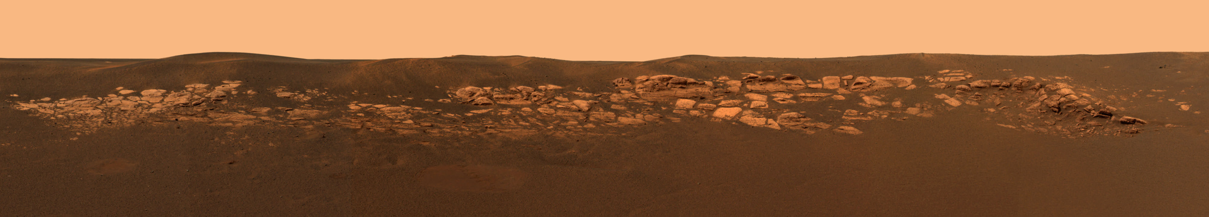
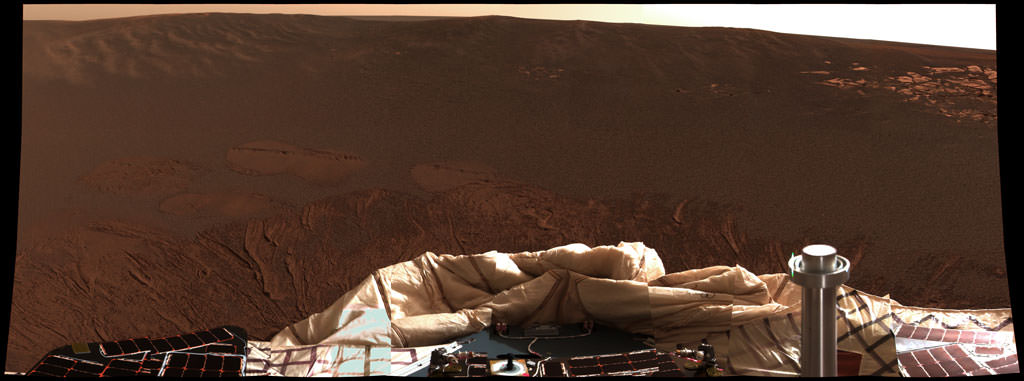
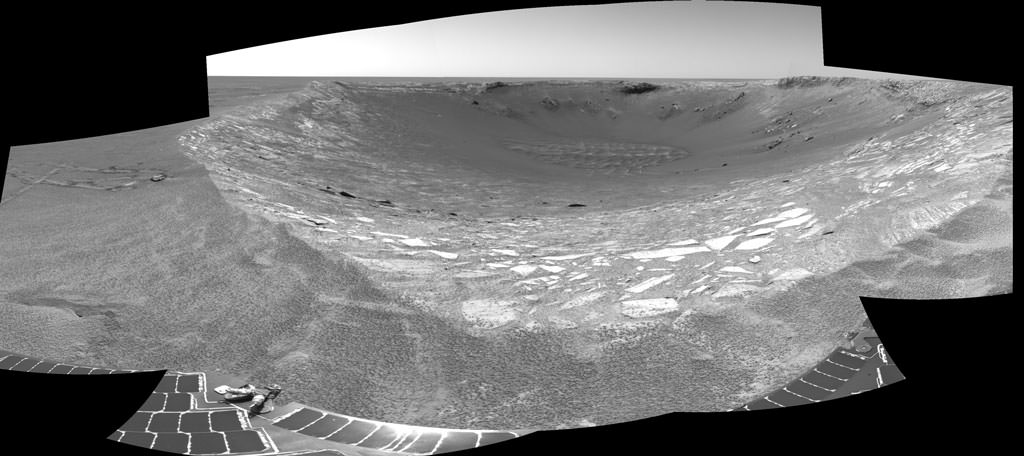
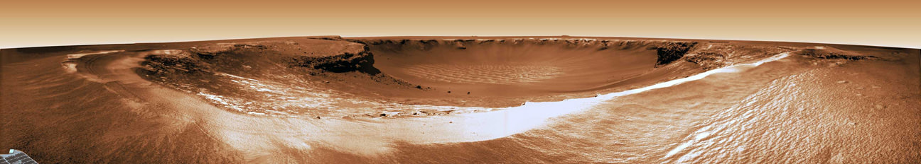
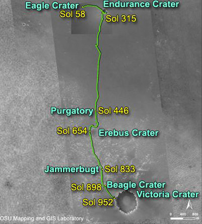
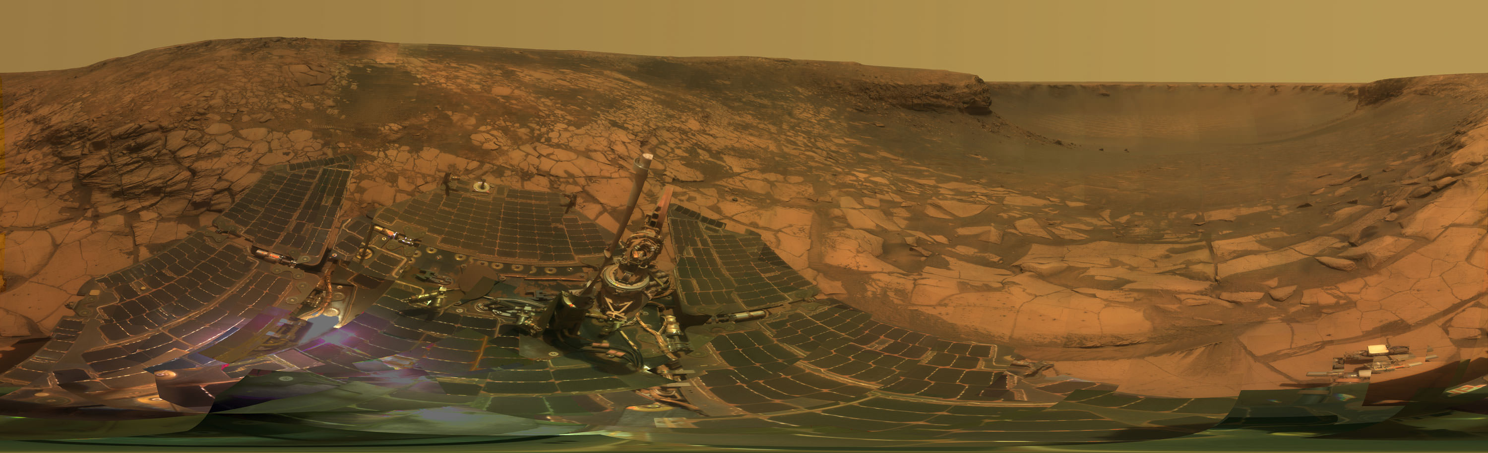
The Long Journey of Opportunity to Santa Maria Crater. This collage of three maps (left, top) and a new close up panoramic mosaic of Santa Maria crater on Sol 2464, Dec 29, 2010 (bottom right) shows the route traversed by the Opportunity Mars rover during her nearly 7 year long overland expedition across the Meridiani Planum region of Mars. Opportunity landed inside Eagle crater on Jan. 24, 2004 and has driven over 26 km (16 mi) since then. Opportunity arrived at the western rim of Santa Maria Crater on Dec. 16, 2010 on Sol 2451 and is driving around the edge in a counterclockwise direction on her way to the huge 22 km wide Endeavour crater which shows signatures of water bearing minerals. The rover is visible in top map taken from orbit by MRO spacecraft. The Panoramic Mosaic of Santa Maria Crater on Sol 2464 - at bottom right – was stitched together from raw images taken by Opportunity’s navigation camera. The rover was about 5 meters from the rim and nearing water bearing materials located roughly at the right of this photomosaic. Credit: NASA/JPL/Cornell Marco Di Lorenzo, Kenneth Kremer
[/caption]
Today, Jan. 24, 2011 marks the 7th anniversary of the safe landing of the Opportunity Mars Exploration Rover (MER). Opportunity will soon celebrate another remarkable milestone – 2500 Sols, or Martian days, roving the red planet. Together with her twin sister Spirit, the NASA rovers surely rank as one of the greatest feats in the annals of space exploration.
“No one expected Spirit or Opportunity to go on this long,” says Ray Arvidson in an interview from Washington University in St. Louis. Arvidson is the deputy principal investigator for the Spirit and Opportunity rovers.
7 Years ago today on Jan. 24, 2004, NASA’s Opportunity rover daringly smashed into the Martian atmosphere at about 12,000 MPH on a one shot, do or die mission with no certainty as to the outcome. Thus began “The Six Minutes of Terror” as the plummeting probes heat shield endured temperatures exceeding 1400°C (2600 F) during the fiery entry, descent and landing phase (EDL).
The spectacular plunge was slowed by atmospheric friction on the heat shield and a complex pre-programmed combination of parachutes and retro rockets, and in the last moments by inflatable airbags designed to allow the robot to bounce about two dozen times and gently and gradually roll to a complete stop.
A Geologist's Treasure Trove at Eagle Crater. Jan 28, 2004.
This high-resolution image captured by the Mars Exploration Rover Opportunity's panoramic camera on Sol 3 highlights the puzzling rock outcropping that scientists were eagerly planning to investigate after safely landing. Opportunity was on its lander facing northeast; the outcropping lies to the northwest. These layered rocks measure only 10 centimeters (4 inches) tall and are thought to be either volcanic ash deposits or sediments carried by water or wind. Data from the panoramic camera's near-infrared, blue and green filters were combined to create this approximate, true-color image. Image credit: NASA/JPL/Cornell
Ultimately, Opportunity survived intact just like her twin sister Spirit who landed safely three weeks earlier on Jan. 3, 2004. EDL was the culmination of a seven month interplanetary cruise of over 250 million miles from Earth. Both rovers were launched from Cape Canaveral, Florida in the summer of 2003 on board Delta 2 rockets. The dynamic duo landed on opposite sides of the Red planet.
Opportunity is now 84 months into the 3 month mission – still alive and blazing a trail of Exploration and Discovery across the Meridiani Planum region of Mars.
The amazing Martian robot has driven more than 16.5 miles (26.7 km) and snapped over 148,000 pictures. She has suffered remarkable few mechanical failures and they have only minimally impaired her ability to traverse across the surface and conduct science operations.
Both rovers survived far beyond the mere 3 month “warranty” proclaimed by NASA as the mission began with high hopes following the nail biting “Six Minutes of Terror”. At the time, team members and NASA officials hoped they might function a few months longer.
“The rovers are our priceless assets” says Steve Squyres, of Cornell University who is the Principal Scientific Investigator for the mission. Squyres and the entire rover team treat every day with a “sense of urgency” and as “a gift to science”.
A Hole in One. Jan. 24, 2004. Sol 1.
The interior of a crater surrounding the Mars Exploration Rover Opportunity at Meridiani Planum on Mars can be seen in this color image from the rover's panoramic camera. This is the darkest landing site ever visited by a spacecraft on Mars. The rim of the crater is approximately 10 meters (32 feet) from the rover. The crater is estimated to be 20 meters (65 feet) in diameter. Scientists are intrigued by the abundance of rock outcrops dispersed throughout the crater, as well as the crater's soil, which appears to be a mixture of coarse gray grains and fine reddish grains. Data taken from the camera's near-infrared, green and blue filters were combined to create this approximate true color picture, taken on the first day of Opportunity's journey. The view is to the west-southwest of the rover. Credit: NASA/JPL/Cornell
Since 2004, the rover’s longevity has surpassed all expectations and nobody on the science and engineering teams that built and operate the twins can believe they lasted so long and produced so much science.
“We have a new Opportunity overview article publishing shortly in the Journal of Geophysical Research (JGR). The Spirit overview paper appeared recently. In addition, there will be about 24 new scientific papers coming out in the new few months as JGR special issues covering more of the MER results. ”
The incredible longevity is “way beyond the wildest expectations of even the people who built the twin sisters” according to fellow Cornell University Professor Jim Bell. “To say the rovers have surpassed expectations is an understatement. We’ve blown them out of the water”. Bell is the lead scientist responsible for the rovers’ high resolution color imaging system called Pancam.
“After 7 years it is still very exciting,“ Arvidson told me. “I am delighted to come to work every day. It’s great to work on the engineering plan for driving and operating the rovers and then see the results the next day.”
Spirit and Opportunity have accomplished a remarkable series of scientific breakthroughs, far surpassing the wildest dreams of all the researchers and NASA officials. Indeed both Mars rovers are currently stationed at scientific goldmines.
Santa Maria is just 6 km from the western rim of Endeavour which shows spectral signatures of phyllosilicates, or clay bearing minerals, which formed in water about 4 billion years ago and have never before been directly analyzed on the Martian surface.
Phyllosilicates form in neutral aqueous conditions that could have been more habitable and conducive to the formation of life than the later Martian episodes of more harshly acidic conditions in which the sulfates formed that Opportunity has already been exploring during her 7 year long overland expedition.
Since the moment she landed inside ‘Eagle’ crater, Opportunity has been on a Martian crater tour her entire lifetime.
Opportunity “scored a 300-million mile interplanetary hole in one,” Steve Squyres said at that time, by improbably rolling to a stop smack inside the small 66 foot wide ‘Eagle’ crater (see map) after bouncing across the virtually flat and featureless dusty plains of Meridiani. She has been a lucky princess from the moment of her birth, spying layered sedimentary rocks in a bedrock outcrop from first light in her cameras a mere 26 feet or so away. That’s unlike any previous lander.
Eagle-eye View of 'Eagle Crater'. March 2004. This image shows the Mars Exploration Rover Opportunity's view on its 56th sol on Mars, before it left its landing-site crater. To the right, the rover tracks are visible at the original spot where the rover attempted unsuccessfully to exit the crater. After a one-sol delay, Opportunity took another route to the plains of Meridiani Planum. This image was taken by the rover's navigation camera. Image credit: NASA/JPL
Seven days later she drove off the landing pad, drilled into the outcrops and collected the “ground truth” science data to prove that hematite was present and liquid water had indeed flowed at Meridiani as a lake or shallow sea on ancient Mars.
After completing her science campaign, she climbed up and over the rim, departed ‘Eagle’ and arrived at ‘Endurance’ about 3 months after landing day.
After numerous tests, Opportunity was commanded to slowly crawl down into the crater. She gradually descending about 30 vertical feet, frequently drilling into the sedimentary rocks and layers to reveal Mars watery past in unprecedented scientific detail for about six months.
In Dec. 2004, Opportunity departed for “Victoria” crater, which many believed would be her final destination. The robot nearly perished in a sand trap at Purgatory along the way during a nearly two year drive across the treacherous martian sand dunes.
Opportunity arrived in Sept. 2006 to unveil Victoria’s Secrets in color. The rover actually wound up spending two years driving to different vantage points around the rim of and then inside the half mile wide crater before departing in Sept 2008 for the unimaginable goal of giant ‘Endeavour’ crater.
The rover team hopes to reach the slopes of Endeavour sometime later in 2011 if all goes well – before her 8th anniversary !
See below some of the best images taken by Opportunity during her 7 Year Martian Trek
Martian Moon Phobos eclipsing the sun on Sol 45Ready to Enter Endurance.
This view looking was taken by the navigation camera on June 6, 2004. That was two sols before Opportunity entered the crater, taking the route nearly straight ahead in this image. This view is a cylindrical projection with geometric seam correction. Credit: NASA/JPLWopmay in False Color .
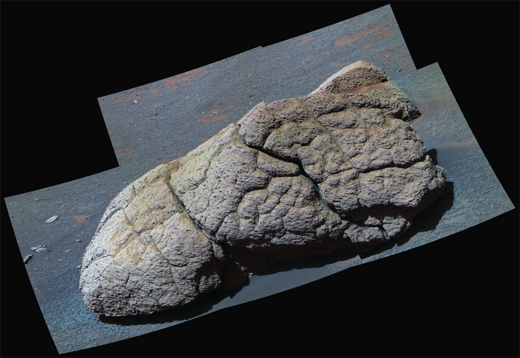
NASA's Mars Exploration Rover Opportunity examined a boulder called Wopmay before heading further east inside Endurance Crater. The frames combined into this false-color view were taken by Opportunity's panoramic camera during the rover's 251st martian day (Oct. 7, 2004). The coloring accentuates iron-rich spherical concretions as bluish dots embedded in the rock and on the ground around it. The rock is about one meter (3 feet) across. Credit: NASA/JPL/CornellBurns Cliff.
Opportunity captured this view of Burns Cliff after driving right to the base of this southeastern portion of the inner wall of Endurance Crater. The view combines frames taken by Opportunity's panoramic camera between the rover's 287th and 294th martian days (Nov. 13 to 20, 2004). The mosaic spans more than 180 degrees side to side. Because of this wide-angle view, the cliff walls appear to bulge out toward the camera. In reality the walls form a gently curving, continuous surface. Image credit: NASA/JPL/CornellOpportunity's Heat Shield in Color, Sol 335.
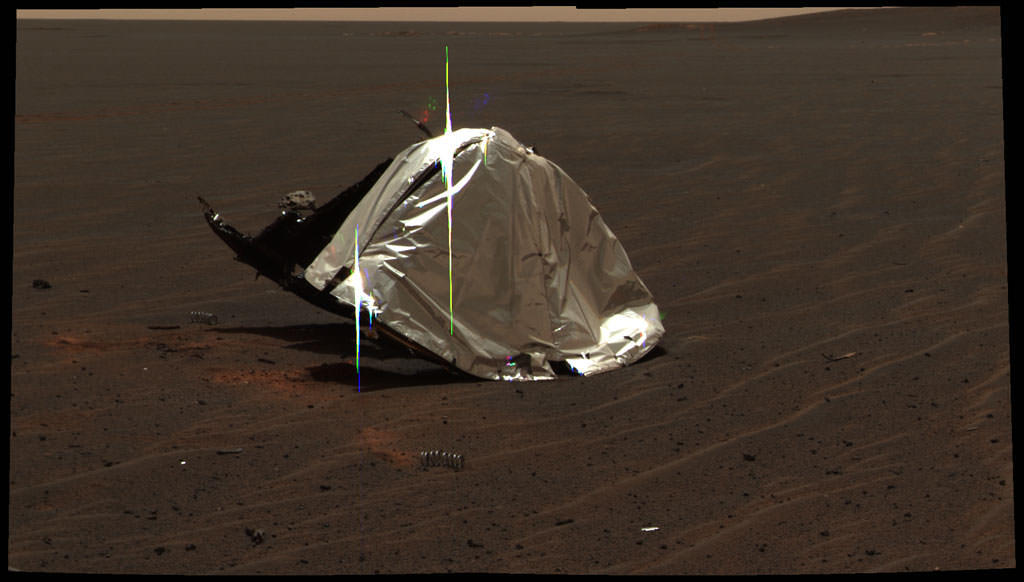
This image from the panoramic camera on NASA's Mars Exploration Rover Opportunity features the remains of the heat shield that protected the rover from temperatures of up to 2,000 degrees Fahrenheit as it made its way through the martian atmosphere. This two-frame mosaic was taken on Sol 335 (Jan. 2, 2005). The view is of the main heat shield debris seen from approximately 10 meters (about 33 feet) away from it. Many rover-team engineers were taken aback when they realized the heat shield had inverted, or turned itself inside out. The height of the pictured debris is about 1.3 meters (about 4.3 feet). The original diameter was 2.65 meters (8.7 feet), though it has obviously been deformed. The Sun reflecting off of the aluminum structure accounts for the vertical blurs in the picture. Iron Meteorite on Mars.
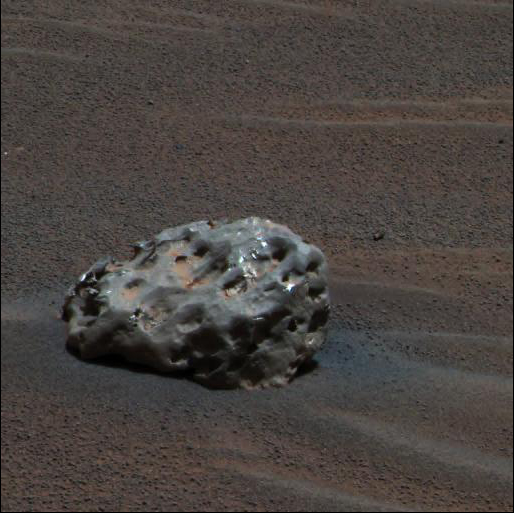
Opportunity finds an iron meteorite on Mars, the first meteorite of any type ever identified on another planet. The pitted, basketball-size object is mostly made of iron and nickel. Opportunity used its panoramic camera to take the images used in this approximately true-color composite on the Sol 339 (Jan. 6, 2005). Credit: NASA/JPL/CornellOpportunity at Crater's Cape Verde in October 2006.
This image from the High Resolution Imaging Science Experiment on NASA's Mars Reconnaissance Orbiter shows the Mars Exploration Rover Opportunity near the rim of Victoria Crater. Victoria is an impact crater about 800 meters (half a mile) in diameter at Meridiani Planum near the equator of Mars. Five days before this image was taken, Opportunity arrived at the rim of Victoria, after a drive of more than 9 kilometers (over 5 miles). It then drove to the position where it is seen in this image. This view is a portion of an image taken by the High Resolution Imaging Science Experiment (HiRISE) camera onboard the Mars Reconnaissance Orbiter spacecraft on Oct. 3, 2006. Credit: NASA/JPL/UA
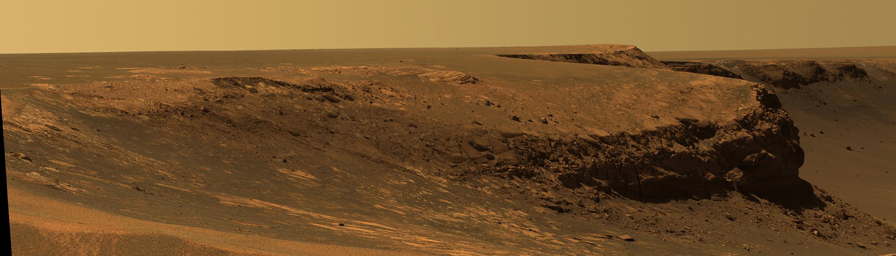
Victoria’s Secret Revealed in Color.
This Opportunity panorama reveals 2,500 ft-wide, 230 ft-deep Victoria Crater from the lip at Duck Bay alcove. Geologic layers reveal the history of Martian water here. The panorama was taken about 8 feet from the crater rim on Sol 952 (28 Sept 2006) as the rover sat between two steep promontories, Cape Verde and Cabo Frio. This vista exposes a thick stack of geologic layers which revealed the hidden watery secrets of the Martian environment farther back in time than any other location visited previously by the rovers. One can see a ½ mile to the distant cliff walls of the crater, above a windswept dune field in the center. This mosaic was assembled from navcam images and featured in Aviation Week & Space Technology magazine and on the Astronomy Picture of the Day (APOD) on 2 Oct. 2006 in high resolution. Credit: NASA/JPL/Cornell, Bernhard Braun, Marco Di Lorenzo, Kenneth Kremer. http://antwrp.gsfc.nasa.gov/apod/ap061002.htmlAstronomy Picture of the Day (APOD) on 2 Oct. 2006 in high resolution
Check out this spherical projection panorama of Opportunity descending inside Victoria Crater on Sol 1332. Credit: NASA/JPL/Cornell/Nasatech.net
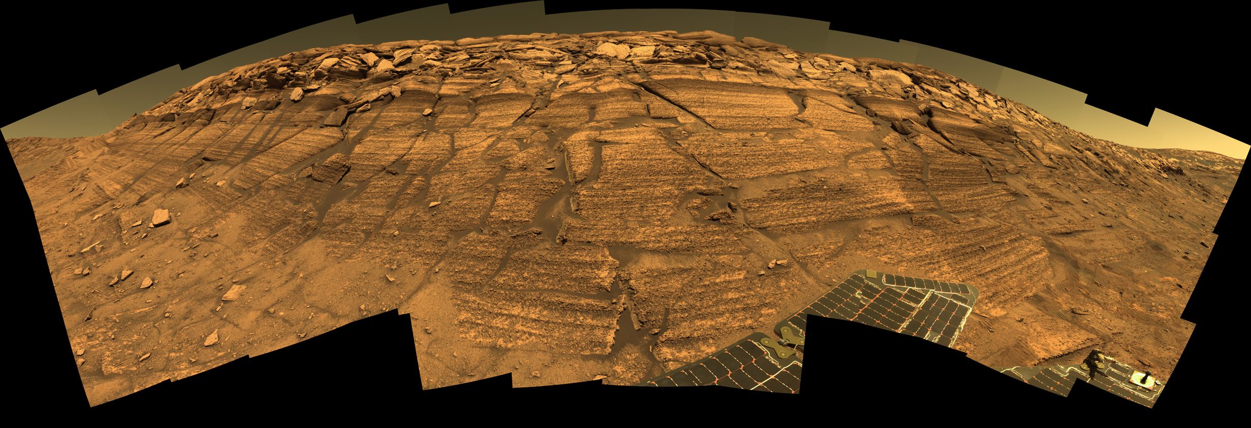
Layers of Cape Verde in Victoria Crater.
This view of Victoria crater is looking north from Duck Bay towards the dramatic promontory called Cape Verde. The dramatic cliff of layered rocks is about 50 meters (about 165 feet) away from the rover and is about 6 meters (about 20 feet) tall. The taller promontory beyond that is about 100 meters (about 325 feet) away, and the vista beyond that extends away for more than 400 meters (about 1300 feet) into the distance. This is an approximately true color rendering of images taken by the panoramic camera (Pancam) on NASA's Mars Exploration Rover Opportunity during Sol 952 (Sept. 28, 2006) using the camera's 750-nanometer, 530-nanometer and 430-nanometer filters. Credit: NASA/JPL/CornellOpportunity Traverse Map, Eagle to Victoria.
NASA's Mars Exploration Rover Opportunity reached the rim of Victoria Crater on Sept. 28, 2006, Sol 952. Opportunity drove 9.28 kilometers (5.77 miles) in the explorations that took it from Eagle Crater, where it landed in January 2004, eastward to Endurance Crater, which it investigated for about half of 2004, then southward to Victoria.Lyell Panorama inside Victoria Crater.
During four months prior to the fourth anniversary of its landing on Mars, Opportunity examined rocks inside an alcove called Duck Bay in the western portion of Victoria Crater. The main body of the crater appears in the upper right of this panorama, with the far side of the crater lying about 800 meters (half a mile) away. Bracketing that part of the view are two promontories on the crater's rim at either side of Duck Bay. They are Cape Verde, about 6 meters (20 feet) tall, on the left, and Cabo Frio, about 15 meters (50 feet) tall, on the right. This view combines many images taken by Opportunity's panoramic camera (Pancam) from the Sol 1,332 through 1,379. (Oct. 23 to Dec. 11, 2007).
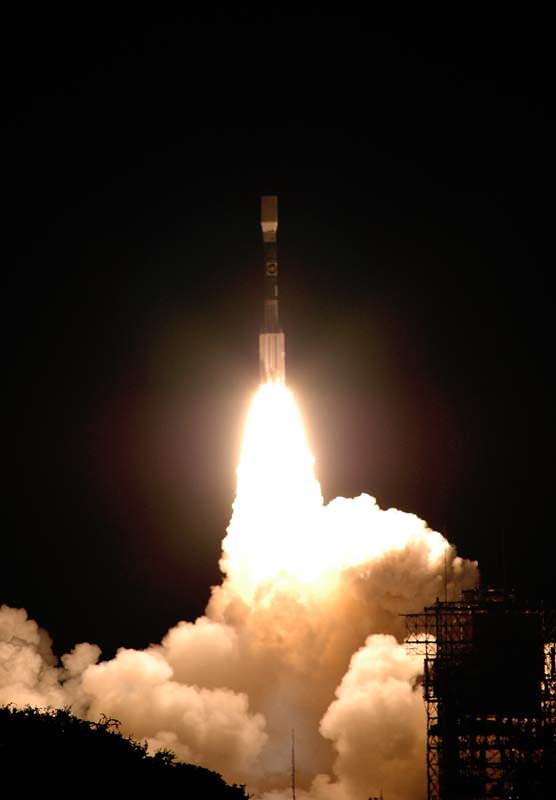
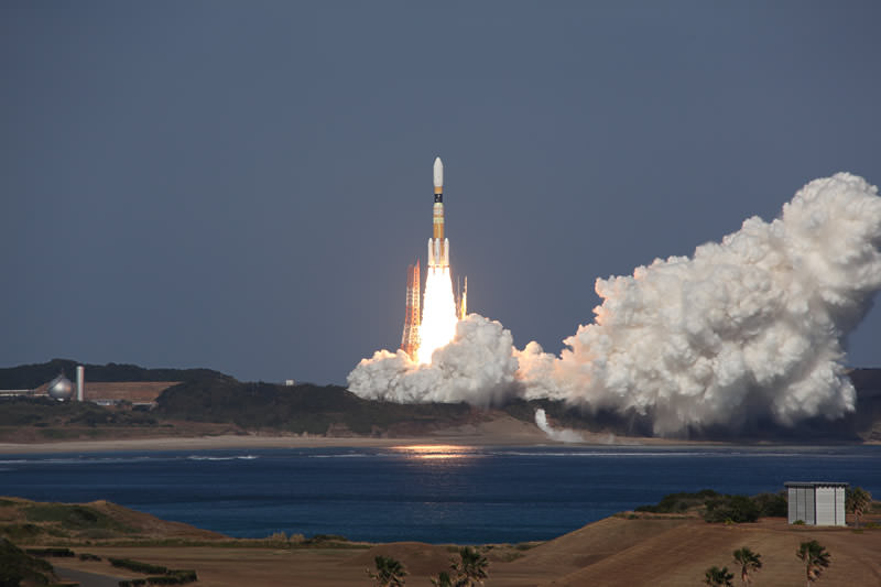
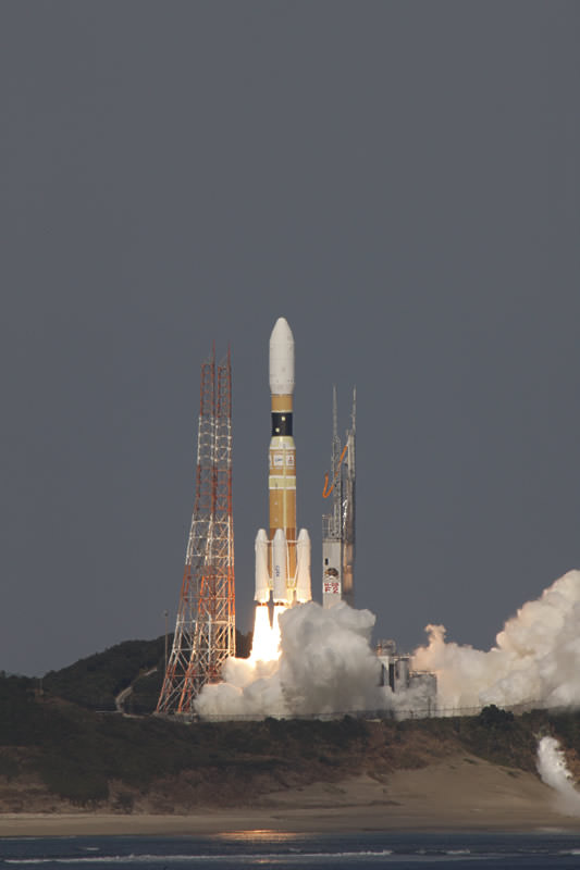
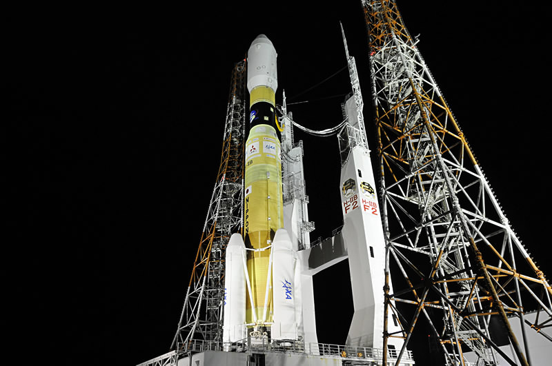
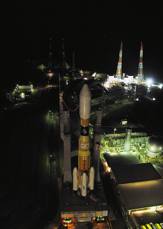
Japan’s H-IIB rocket blasts off with the Kounotori2 cargo resupply transporter at 2:37:57 p.m. on January 22, Japan Standard Time, (12:37:57 a.m. EST) from the remote island launching base at Tanegashima Space Center in southern Japan. Kounotori2 is loaded with crucial supplies destined for the International Space Station (ISS). Credit: JAXA. Watch 2 Launch Videos Below. Japanese video captures exquisite receding view of the Earth’s curvature and Solid Rocket Booster (SRB) separation during climb to orbit.
[/caption]
A Japanese rocket successfully blasted off early this morning (Jan. 22) on a vital mission bound for the International Space Station (ISS). The launcher carried the Kounotori2 – which means ‘White Stork’ in Japanese – cargo resupply vessel. Kounotori2, also dubbed HTV2, is stocked with over 3800 kilograms (8000 pounds) of crucial science experiments, research gear, food and provisions for the six person international crew living aboard the Earth orbiting outpost.
Liftoff of the unmanned H-IIB rocket from Launch Pad No. 2 at the Tanegashima Space Center occurred earlier today at 2:37:57 p.m. on January 22, local Japan Standard Time (12:37:57 a.m. EST), from a remote island rocket base located in southern Japan.
Watch 2 Videos of the launch below. Especially be sure to view the Japanese version (interspersed with English) which captured dramatic rear-looking video of the receding Earth and its curvature and the separation of the Solid Rocket Boosters (SRBs) – during the ascent to orbit.
The launch was flawless in all respects. The Japanese Space Agency – JAXA – confirmed that the Kounotori2 cargo carrier separated from the launch vehicle as expected at about 15 minutes and 13 seconds after liftoff.
Blast off of the 186 foot tall rocket had been delayed two days by poor weather. By the time of Saturday’s launch, the weather had cleared with a wind speed of 8.3 meters/second from the north-west and the temperature was 10.6 degrees Celsius according to JAXA.
The H-IIB is a two-stage rocket powered by liquid oxygen and liquid hydrogen with four strap-on solid rocket boosters (SRBs) powered by polybutadiene. The SRB’s were jettisoned as planned about two minutes into the flight (see video).
Rendezvous at the ISS is scheduled to take place on Jan. 27.
After the HTV2 arrives in close proximity, astronauts on board will manually dock the cargo ship to the station. Using the stations Canadian built robotic arm, known as Canadarm2, the Expedition 26 crew of Cady Coleman and Scott Kelly from the US and Paolo Nespoli from Italy will grapple HTV2 and berth it to the Earth-facing port on the Harmony module.
Japanese Space Agency – JAXA – HTV Launch Video. In Japanese – interspersed with English
Video Caption: The H-IIB Launch Vehicle No. 2 with the KOUNOTOR 2 (HTV 2) cargo transporter onboard launched from the Tanegashima Space Center in southern Japan at 2:37:57 p.m. on January 22, Sat., Japan Standard Time, (12:37:57 a.m. EST) and is bound for the International Space Station (ISS). KOUNOTORI 2 translates as ‘White Stork’ in Japanese.
HTV Launch with NASA Commentary
HTV1 in flight to the ISS. The HTV, or KOUNOTORI, is an unmanned cargo transporter to be launched by the H-IIB launch vehicle. It is designed to deliver up to six tons of supplies including food, clothes, and experiment devices to the ISS in orbit at an altitude of about 400 kilometers and return with spent equipment, used clothing, and other waste material. Credit: NASA HTV2 weighs 16,061 kilograms (35,408 pounds) and measures 10 meters long by 4 meters wide (33 feet by 13 feet). The vehicle can deliver both internal and external cargo to the station. In addition to Japanese equipment, the freighter is also loaded with over 2200 kg of experiments and supplies from NASA and Canada including both pressurized and unpressurized items.
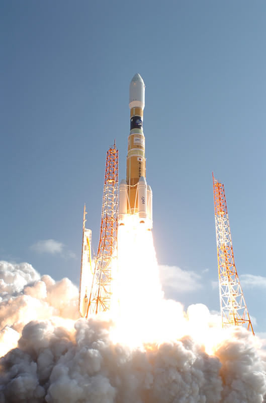
The H-II Transfer Vehicle 2 (Kounotori 2) during media day at the JAXA Tanegashima Space Center, Kagoshima Prefecture, Japan on Nov. 25, 2010. Vehicle is fully assembled. Credit: Japan Aerospace Exploration Agency
This was the second launch of the HTV cargo carrier which was developed by the Japan Aerospace Exploration Agency (JAXA). The maiden launch occurred in September 2009 and was a test flight to demonstrate the autonomous and remotely-controlled rendezvous capabilities while also delivering cargo and supplies to the ISS.
Japan expects to construct and launch about one HTV per year with the capability to ramp up production to two vehicles per year if necessary and if the Japanese government approves funding.
JAXA is evaluating the possibility to convert the HTV into a vehicle capable of flying humans to space.
China, the other Asian superpower, has already established a human spaceflight program.
China has successfully launched three manned capsules to space and is vigorously moving forward with plans to orbit a manned space station.
After the forced retirement of the Space Shuttle later this year, NASA will be completely dependent on commercial companies and foreign governments to launch all of its future cargo requirements to the ISS.
More HTV 2 launch and launch processing photos below from JAXA
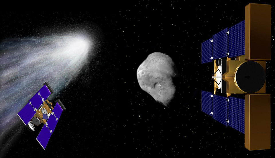
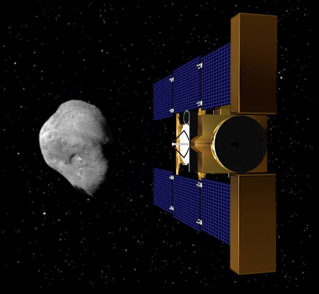
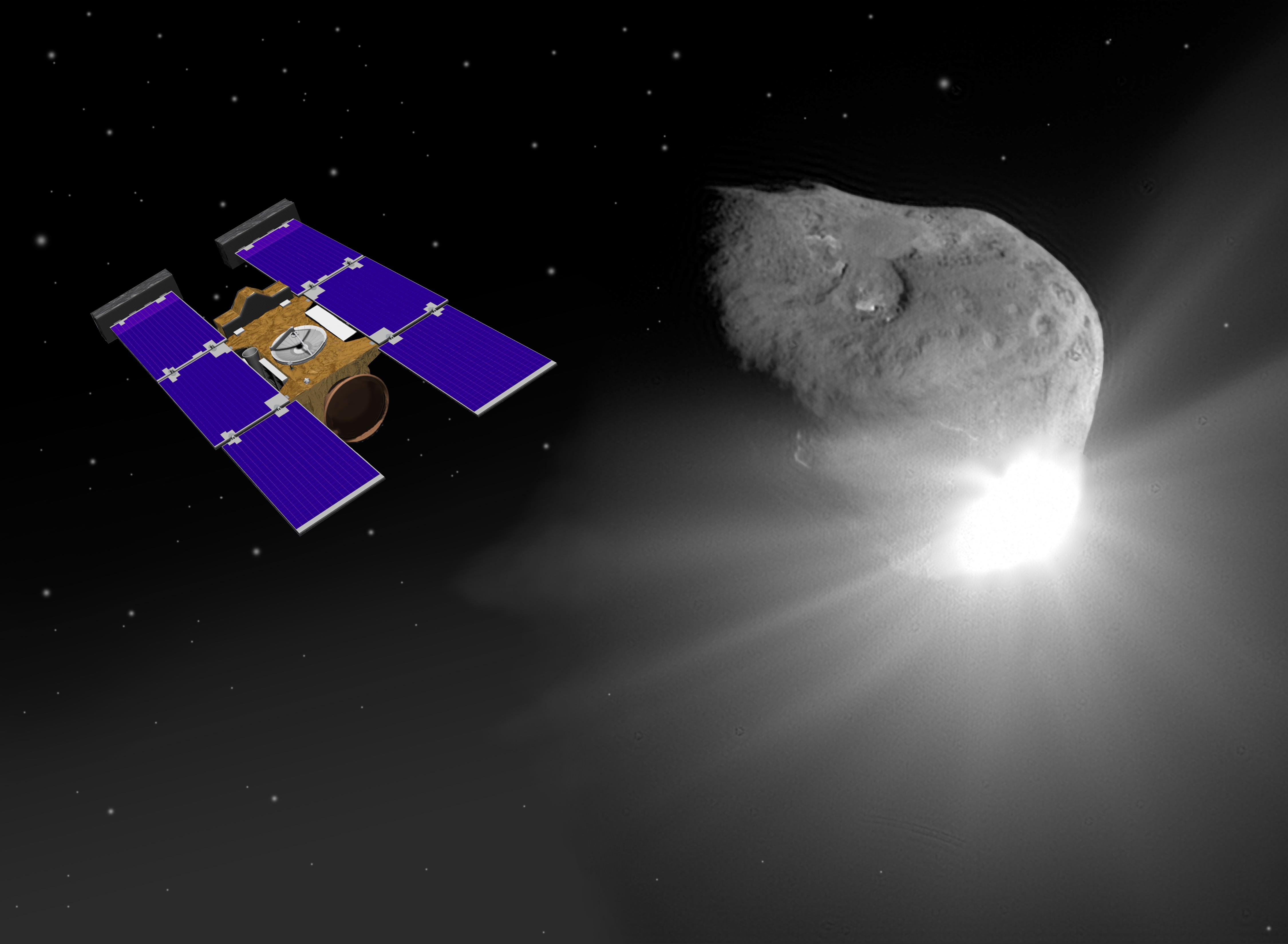
Stardust-NExT: 2 Comet Flybys with 1 Spacecraft. Stardust-NExT makes history on Valentine’s Day - February, 14, 2011 – by becoming the first spacecraft to visit 2 comets and gather science data: Comet Wild 2 in 2004 (left) and Comet Tempel 1 in 2011 (right). Artist renderings Credit: NASA. Collage: Ken Kremer. See video below of Jan 19, 2011 Media briefing from the Science Team about plans for the Temple 1 cometary encounter
[/caption]
After a more than decade long journey of 6 billion kilometers, hopes are high for a celestial date in space between an icy comet and a thrusting probe on Valentine’s Day 2011. The rendezvous in space between NASA’s approaching Stardust-NExT spacecraft and Comet Tempel 1 takes place nearly on the exact opposite side of the Sun on Feb 14, 2011 at approximately 11:37 p.m. EST (8:37 p.m. PST).
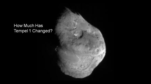
The top science goal is to find out “how much the comet’s surface has changed between two close passages to the sun” since it was last visited in 2005, said principal investigator Joe Veverka of Cornell University, Ithaca, N,Y at a media briefing today, Jan 19, at NASA Headquarters. Indeed it’s the first time in history that a comet has been visited twice by space probes from Earth.
The lead scientists and engineers outlined the plans for the cometary flyby at the briefing. See a video of the entire briefing below.
Since the last visit in 2005, the comet has completed another orbit around the sun. “It will be the first time we’ll be able to see changes after a comet has passed through one perihelion,” explained Veverka. Tempel 1 belongs to the Jupiter family of comets and orbits between Mars and Jupiter.
Comet Tempel 1 suffered a cosmic collision during that first encounter with an emissary from Earth when NASA’s Deep Impact smashed a copper projectile directly into the comets nucleus. The blast created an impact crater and ejected an enormous cloud of gas and debris. Reflected light off the dust particles totally obscured the view of the crater and prevented any images from being taken. Researchers had hoped to determine the size of the crater. A lot of bets hinge on that determination.
“We have a chance to complete the Deep Impact experiment. We hope to see how big the impact crater is and what that tells us about the mechanical properties, ” said Veverka.
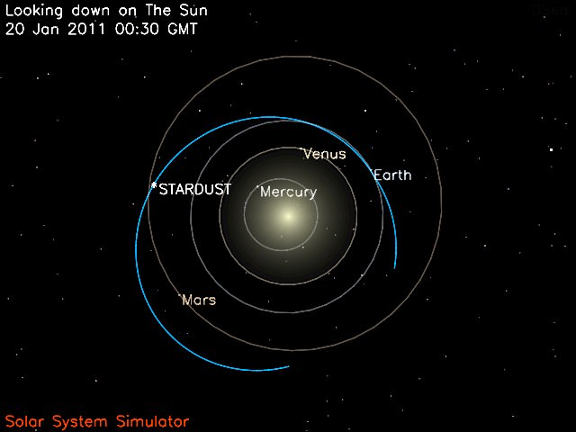
20 Jan. 2011 Position of STARDUST-NExT probe - Looking Down on the Sun.
This image shows the current position of the STARDUST-NExT spacecraft and the spacecraft's trajectory (in blue) around the Sun. Credit: NASA
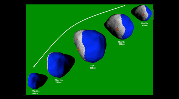
With just over 3 weeks remaining, the craft is approximately 24.6 million kilometers (15.3 million miles) away from its encounter. Stardust-NExT will zoom past the nearly 6-kilometer-wide comet (3.7 miles) at a distance of approximately 200 kilometers (124 miles) and at a speed of 10 km/sec according to Tim Larson, the mission’s project manager from the Jet Propulsion Laboratory (JPL), Pasadena, Calif.
“The spacecraft is still working well 12 years after launch. This is a bonus mission with a scientifically desirable target which we can get close to,” said Larson.
“Everything will happen autonomously,” stated Larson. “The craft will be about 2 AU away from Earth at encounter. Since the round trip signals will take about 40 minutes there is no chance for any real time changes.”
Different features on Tempel 1 discovered by Deep Imapct in 2005. Credit: NASA
“Stardust-NExT will take 72 high resolution images during the close approach encounter. These will be stored in an onboard computer and relayed back to Earth starting about an hour later. It will take about 12 hours to get them all back.”
NASA says that after processing, the images are expected to be available at approximately 4:30 a.m. EST (1:30 a.m. PST) on Feb. 15.
“For the first time we’ll go back to see what happens to a comet since our last visit,” explained Pete Schultz, co-investigator of Brown University, Providence, R.I. “The comet has been out to the orbit of Jupiter and back to Mars and had several outbursts of gas and dust. In 2005 we saw old and new surfaces. So it has a complicated geologic history. We hope to resolve the crater and see ejecta. But there are many unknowns. What we see – whether its the crater or the other unseen side – all depends on the rotation of the comet nucleus.”
“The comet dynamics are complex and erratic, not inert,” said Steve Chesley, a co-investigator at JPL. “They are like a rocket with no one at the controls. The orbit can change. So it is a huge challenge to target a spacecraft for a flyby or rendezvous.”
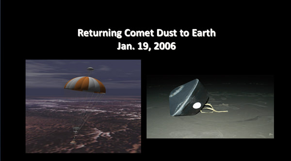
Stardust successful original mission was to fly by Comet Wild 2 on Jan 2, 2004. It then returned cometary dust particle in a sample return canister to Earth on Jan. 19, 2006 which reentered the atmosphere at the highest speed ever and parachuted to a safe landing. Credit: NASA
Stardust-NeXT is a repurposed spacecraft. The Valentine’s Day encounter will be the last hurrah for the aging probe. Stardust was originally launched way back in 1999. It flew by Comet Wild 2 on Jan. 2, 2004 and collected cometary dust particles which were returned to Earth in a sample return capsule in Jan. 2006. Since then it has continued its solitary voyage through the void of the space.
The craft is nearly out of fuel and all movements consume fuel. It is totally dependent on the reaction control thrusters for navigating through space and pointing its camera and science instruments, said Larson.
“We are confident that we will have enough fuel to finish up this mission. It has been a big, big challenge to maintain a reserve supply. After the mission there won’t be much left that the spacecraft can do. The last trajectory correction maneuver is two days before arrival. That is also when we will take our last optical navigation images for targeting the spacecraft.”
.
Only about a third of the surface of Tempel 1 was photographed by Deep Impact in 2005. “We’ll be looking at old territory and new and some overlap,” explained Veverka. “The science team is awfully excited and just can’t wait to see the pictures on Valentine’s day.”
“We have no idea how quickly the surface features change and whether its millions of years or days,” concluded Veverka.
“We expect new discoveries no matter what we see,” Larson summed up
Stardust-NExT Spacecraft & Comet Tempel 1. Artist rendering of Stardust-NExT spacecraft nearing Comet Tempel 1 for upcoming flyby on February, 14, 2011. Credit: NASA
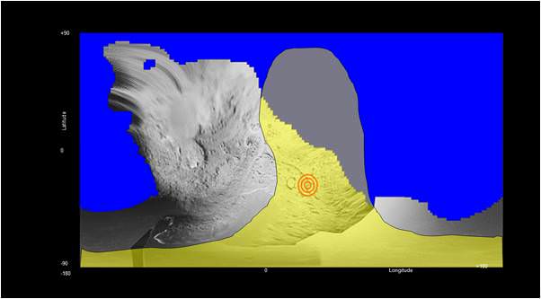
See video and graphics below of Jan 19, 2011 Media briefing from the Science Team about plans for the cometary encounterPlanned imaging of Comet Tempel 1 by Stardust-NExT during flyby. Blue area is unseen and unmapped territory never imaged by Deep Impact during 2005 flyby. Bulls eye in yellow area is expected location of 2005 impact crater and expected new coverage. There is some overlap. Credit: NASAPlanned imaging of Comet Tempel 1 by Stardust-NExT during flyby. Blue area is unseen and unmapped territory never imaged by Deep Impact during 2005 flyby. Credit: NASA
Jan. 19, 2010: Science Team Media Briefing
The Stardust spacecraft has been repackaged for the Stardust-NexT mission. Stardust-NExT will rendezvous with Comet Tempel 1 on February 14, giving scientists an opportunity, for the first time, to search a comet’s surface for changes following its orbit around the sun. Mission scientists discussed the relevance of the mission at a briefing at NASA headquarters in Washington Stardust successful original mission was to fly by Comet Wild 2 on Jan 2, 2004 and return cometary dust particle to earth in Jan. 2006. It is equipped with 3 science instruments. Credit: NASA
Developing coronal holes. Two coronal holes that develop over several days stand out in this image taken of the Sun from SDO's AIA instrument on Jan. 12, 2010. Coronal holes are areas of the Sun's surface that are the source of open magnetic field lines that head way out into space. Credit: NASA
[/caption]
A pair of coronal holes on the Sun newly imaged by NASA’s flagship solar probe, the Solar Dynamics Observatory (SDO) may cause auroral activity here on Earth soon.
The pair of holes were captured in images taken from Jan 9-12, 2011 by SDO’s AIA instrument in the extreme untraviolet (UV). The images – shown above and below – were also made into a cool timelapse video (shown below) of the rotating sun and were released by NASA as “SDO Pick of the Week” for Jan. 14, 2011.
SDO research results on the solar corona are featured as the cover photo and story for the current issue of Science magazine on Jan. 7, 2011. Updated
Science magazine Jan. 7 2011, COVER.
Multiwavelength extreme ultraviolet image of the Sun taken by the Solar Dynamics Observatory's Atmospheric Imaging Assembly. Colors represent different gas temperatures: ~800,000 kelvin (K) (blue), ~1.3 million K (green), and ~2 million K (red). New observations reveal a link between hot plasma and jets propelled upward from the region immediately above the Sun's surface and help explain why the Sun's outer atmosphere, or corona, is much hotter than its surface. Image: NASA/Solar Dynamics Observatory/Atmospheric Imaging Assembly (AIA)
Click to enlarge all images
Coronal holes on the sun’s surface are the source of open magnetic field lines and are areas from which high-speed solar wind particles stream out into space. The fast solar wind travels at approximately 800 km/s (about 1.8 million mph). After traveling through space for a few days the particles will impact the Earth and may spark the formation of some auroral activity for lucky spectators.
The two holes developed over several days. In a video here, one hole is above the suns equator and the other is below. According to a NASA press release, the coronal holes appear dark at the extreme UV wavelength of 193 Angstroms because there is just less of the material – ionized iron- that is being imaged.
2 D Video: A Hole in the Sun’s Corona
Caption: This timelapse video shows a coronal hole, as captured in ultraviolet light by NASA’s Solar Dynamics Observatory around Jan. 10, 2011. Coronal holes are areas of the sun’s surface that are the source of open magnetic field lines that head way out into space. They are also the source regions of the fast solar wind, which “blows” at a relatively steady clip of 1.8 million mph. (No audio). Credit: NASA
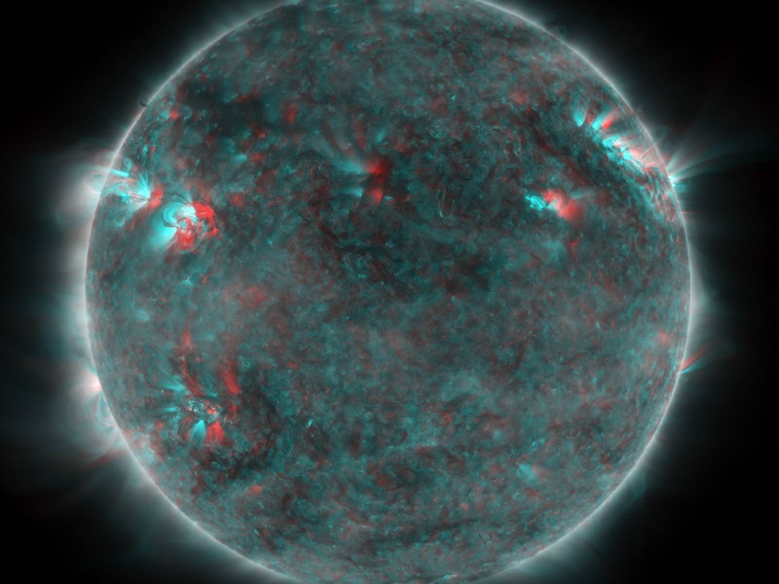
3 D Video: Coronal holes from STEREO
Check out this 3 D movie of a coronal hole snapped by NASA’s twin STEREO solar probes orbiting the sun. You’ll need to pull out your red-cyan 3 D anaglyph glasses. First, watch the short movie with you 3 D glasses. Then, I suggest to pause the movie at several intervals for a longer look. Remember – its red on the left eye.
Caption: This STEREO image features an active region and a coronal hole. The hole is the large dark spot in the middle of the sun. Coronal holes are the source of solar wind and a generator for space weather activity. Credit: NASA
SDO roared to space on February 11, 2010 atop a powerful Atlas V rocket from Cape Canaveral Air Force Station in Florida. Launch photo below.
The billion dollar probe is the “crown jewel” in NASA’s solar fleet and will soon celebrate its first anniversary in space. SDO’s mission is to explore the Sun and its complex interior mechanisms in unprecedented detail. It is equipped with three science instruments (HMI, AIA, and EVE)
This Solar Dynamics Observatory image of the Sun taken on January 10, 2011 in extreme ultraviolet light captures a dark coronal hole just about at sun center. Coronal holes are areas of the Sun's surface that are the source of open magnetic field lines that head way out into space. Credit: NASASDO blast off on Feb. 11, 2010 atop Atlas V rocket from Pad 41 at Cape Canaveral as viewed from the KSC press site. Credit: Ken KremerSolar 3 D in Extreme UV - from SDO.
This 3 D image was created by combined two images that were taken in one extreme UV wavelength about 8 hours apart on June 25, 2010. The Sun's rotation created enough of a perspective change for this to work. Although the SDO mission cannot produce true 3D images of the Sun like STEREO, 3D solar images can still be made from SDO images. Credit: NASA/SDO
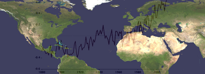
World map with global temperature changes from 1880 to 2010. Credit: NASA GISS
[/caption]
Newly released scientific data shows that 2010 equals 2005 as the Earths warmest year on record over the last 131 years, say researchers from NOAA and NASA. Temperature measurements from instrumented monitoring stations date back to 1880.
The past decade from 2001 to 2010 was the warmest on record and includes 9 of the 10 hottest years. A NOAA ranking of the 15 hottest years globally shows they all occurred in the last 15 years since 1995.
2010 was the 34th consecutive year with global temperatures above the 20th century average of 57.0 F (13.9°C), according to NOAA data. 1976 was the last year with a below average global temperature. Updated.
Global surface temperature anomalies for 2010. Credit: NOAA
Overall, the combined global land and ocean surface temperatures for 2010 and 2005 has risen 1.12 F (0.62 C) compared with the 20th century average, according to NOAA. The average global temperature in 2010 was 58.12 degrees compared to 57.0 F (13.9°C) as the average for all of 20th century. 2010 was also the wettest year on record.
The rise in Earths’ global temperature has been accompanied by a decline in arctic sea ice. Specifically, surface air temperatures in the arctic were warmer than normal during the summer of 2010. The sea ice extent measured in September 2010, was the 3rd lowest on record since accurate monitoring began in 1979, states NOAA in the annual Arctic report card. See Video below.
Scientists from NOAA’s National Climatic Data Center (NCDC) in Asheville, N.C. and NASA’s Goddard Institute for Space Studies (GISS) in New York City announced the findings on Jan 12. The temperature data are collected by weather stations that span across the globe.
Global measurements by independent researchers in the UK at the Met Office Hadley Centre and at the Japanese Meteorological Agency closely match the trend of warming temperatures gathered by NOAA NCDC and NASA GISS.
The graphic below combines the actual temperature data collected independently by the four research agencies. The temperature trend lines are remarkably consistent.
Multiple institutions monitor global surface temperatures. Despite subtle differences in the ways the scientists perform their analyses, these four widely referenced records show remarkable agreement. Credit: NASA Earth Observatory/Robert Simmon
Much of the rise in global temperatures has taken place since the late 1970’s, says NASA. The rate of increase has been about 0.36 F per decade. The NASA GISS weather data were collected using over 1000 meteorological stations around the world, satellite observations of sea surface temperature and Antarctic research station measurements.
2010 average annual temperature ranks by state in the US. Credit: NOAA
The data are fed into a computer program which then calculates temperature anomalies — the difference between surface temperature in a given month and the average temperature for the same period during 1951 to 1980. NASA GISS uses that three-decade period as the baseline for analysis against which climate change can be tracked. NOAA uses the entire 20th century.
For the contiguous United States, NOAA analysis shows that “2010 was the 14th consecutive year with an annual temperature above the long-term average. Since 1895, the temperature across the US has increased at an average rate of approximately 0.12 F per decade.”
There are large areas in the Arctic without weather stations. NASA GISS approaches the problem by filling in gaps with data from the nearest land stations. The Climatic Research Unit at the University of East Anglia, which works jointly with the Met Office Hadley Centre, leaves much of the region out of its global temperature analysis. Credit: NASA Earth Observatory/Robert Simmon2010 Global Significant Weather and Climate Events. Credit: NOAA Global Temperatures.
The year 2010 tied with 2005 as the warmest year since records began in 1880. The annual global combined land and ocean surface temperature was 0.62°C (1.12°F) above the 20th century average. The range associated with this value is plus or minus 0.07°C (0.13°F). The 2010 combined land and ocean surface temperature in the Northern Hemisphere was also the warmest on record, while the combined land and ocean surface temperature in the Southern Hemisphere was the sixth warmest such period on record. Credit: NOAA
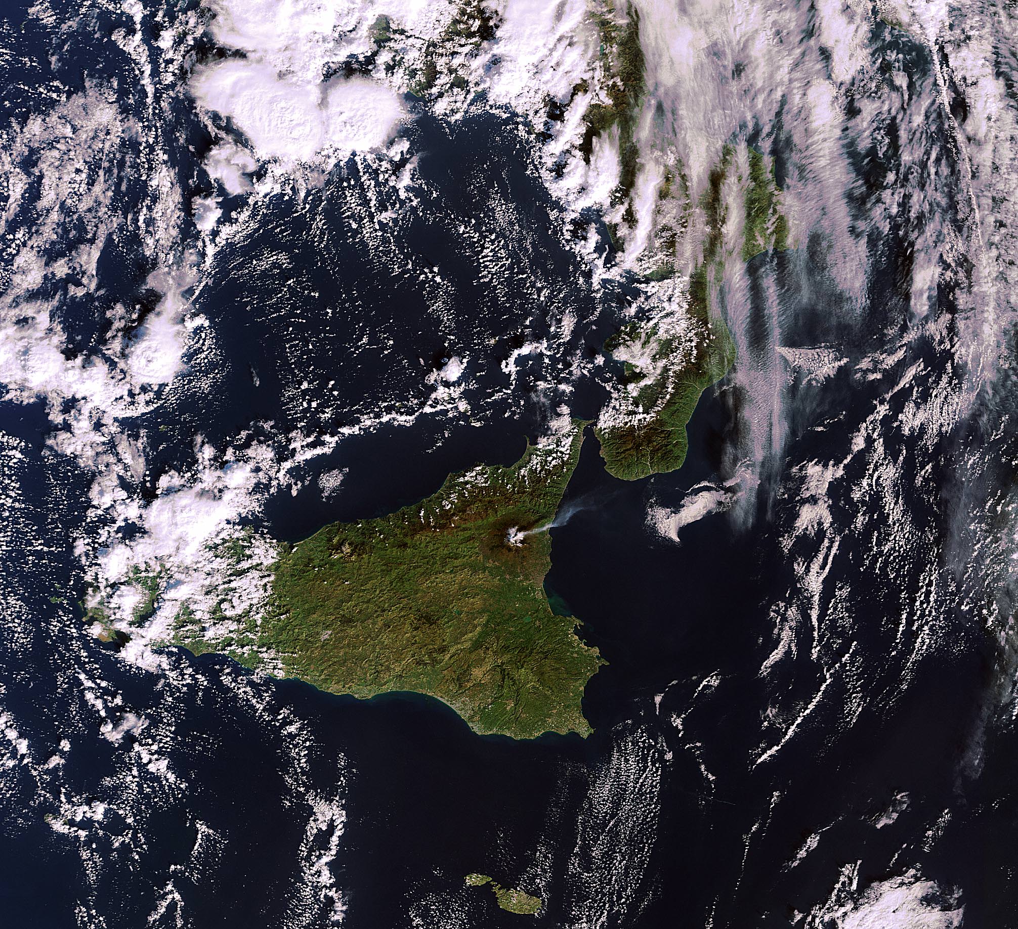
Volcanic eruptions at Mt. Etna from orbiting NASA Terra Satellite. Acquired on January 11, 2011. NASA Earth Observatory Image of the Day on January 15, 2011. Credit: NASA Terra Satellite
[/caption]
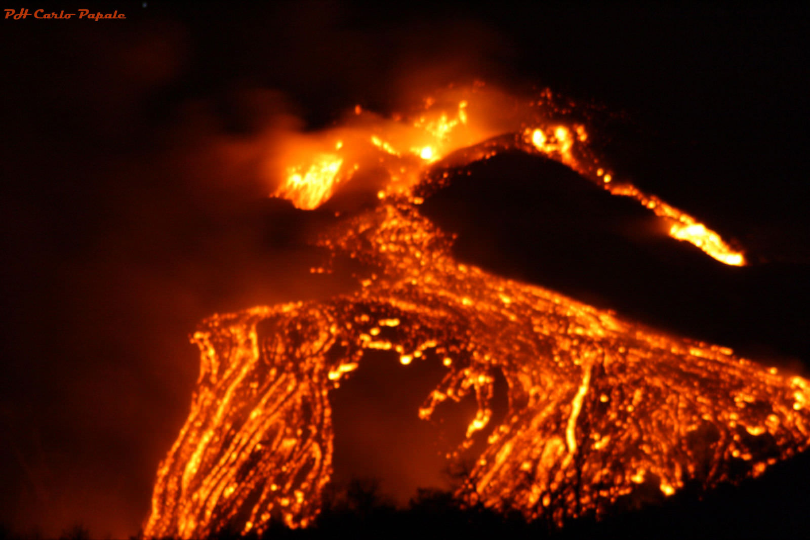
Spectacular eruptions from Mt Etna are spewing massive quantities of lava, smoke and ash many hundreds of meters high into the skies above the island of Sicily. Mt Etna is the most active volcano in Europe and one of the most active on all of Earth. The volcano rumbled to life again this week on the evening of January 12, 2011 and lit up the night sky. Mt Etna is 3350 meters high and located on the northeast coast of Sicily near the boot of Italy (see above, below).
Updated: comment or send me your Etna erupting photos/accounts to post below.
This fearsome natural wonder is providing an awe inspiring show from both Earth and Space. Local residents and lucky tourists nearby took stunning videos and photos (below) showing fountains of brilliant lava eruptions streaming mightily from the volcano.
This Envisat MERIS image, acquired on 11 January 2011, shows the plume of smoke billowing into the atmosphere from Mount Etna, Sicily, Italy. Activity gradually increased the following day, peaking in the evening. Credits: ESA
Click to Enlarge all images
Amazing photos from space were captured by Earth orbiting satellites from NASA and ESA. NASA’s Terra satellite took the above image on Jan. 11 as Mt Etna was spewing forth smoke or ash just prior to the volcanic eruptions on Jan. 12. The photo of Etna is NASA’s Earth Observatory Image of the Day, today, Jan. 15, 2011.
ESA’s Envisat likewise snapped a gorgeous view of the billowing plume of smoke rising to space (photo at left) and the international crew aboard the ISS, which currently includes Italian astronaut Paolo Nespoli. Perhaps he’ll send us a shot !
Local news and eyewitness accounts say that tremors from the volcano began increasing on Jan. 11. Emissions of volcanic gases and water vapor have been ongoing since late September 2010. The sounds of explosive tremors from deep inside were also detected months ago.
This sizzling hot video – “Etna at Maximum Activity” – is set to music and records the magnificent flowing streams of lava and the thunderous sounds of the crackling, explosive eruptions. Be sure to view at full screen, then just sit back and enjoy !
Plumes of volcanic ash from the eruptions spread across Sicily and forced the closure of the local Fontanarossa airport – nearby to the city of Catania, which is 24 kilometers away.
Rumblings of Mt Etna have been recorded in historical documents dating back to about 1500 BC.
Another short, dramatic video with the raw sounds of the eruption from a group of German tourists visiting the beautiful city of Taormina, Sicily
Eyewitness Description:
“Mount Etna erupted in the evening of January 12, 2011 for around four hours, providing an amazing scenery. We shot this unique video from Taormina on January 12, 2011 at 11.45 p.m. and uploaded it on YouTube.
On the evening of 11th January 2011 an increase in volcanic tremor was recorded at the summit of the volcano. The recorded seismic activity reached a peak at 7 a.m. on 12th January when the source moved from north of NE crater to the SE crater. The eruption started with strombolian explosive activity at SE crater at around 9.p.m. Lava overflowed the eastern rim of SE crater and fed a flow that moved toward the western wall of the Valle del Bove (Valley of the oxen), an ancient huge uninhabited depression on the NE side of the volcano.
The Sicilian communities near the volcano were not threatened by this latest fascinating eruption. Best place to watch the fascinating eruptions of Mount Etna is the town of Taormina, nestled on a hill at 220 meters / 722 feet above the sea level and at a safe linear distance of approx. 28 Km / 17,4 miles from the top craters of the Sicilian volcano.” Fearsome lava eruptions spewing from Mt Etna on Jan. 11, 2011
A few years back, I visited Mt Etna and was incredibly lucky to witness this spectacle of nature myself. It was an unforgettable experience to see the glowing red-orange colored lava flowing out from the bowels of the Earth. It was like a living being with circulating blood.
In the excitement, I did something that in retrospect was incredibly stupid. I stood on a ledge, perhaps 50 cm thick, right above the porthole of the scalding hot lava erupting from the earth beneath my feet. Many others did too.
Sicily is a lovely place of manmade and natural wonders. Don’t pass up an opportunity to see Etna aflame
Look at Etnaweb (in Italian, but Universal) for a fantastic collection of local photos and webcams of the eruption.
Volcanic eruptions are breathtaking events to behold. The residual plumes of smoke and ash can stay aloft for many years and can also effect how we see other astronomical events such as our view of solar and lunar eclipses.
For a more tranquil view of Earth and inspiration from Carl Sagan, click here
NASA’s Spirit robot is positioned next to an ancient and extinct volcanic feature on Mars. Learn more here
Can you envision a place hotter than Etna ? … A scorching, molten hellish world where the temperatures are unimaginably hot
Comment or send me your photos and eyewitness accounts of erupting Mt Etna
Signs of activity at the summit of Mount Etna, Europe’s most active volcano.
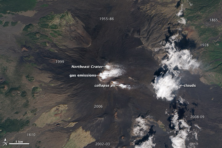
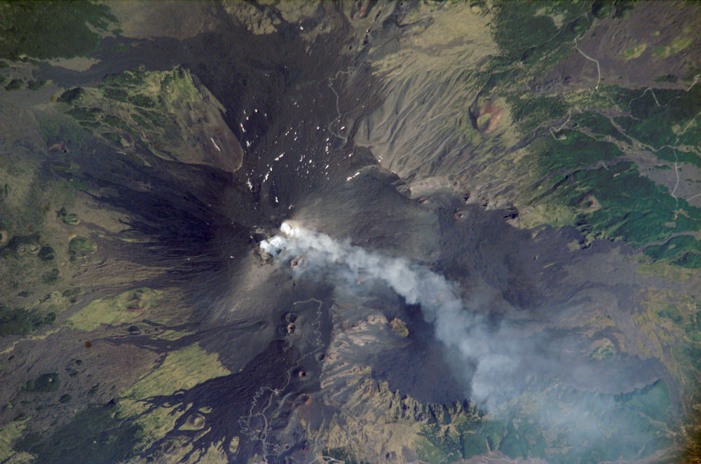
Water vapor and other volcanic gases overflow Etna’s summit craters, spilling out over the volcano’s upper slopes. A steam plume rises from a collapse pit that formed in late 2009, the newest volcanic feature on Etna. Dark lava flows from recent eruptions cover the peak, overlaying lighter, weathered flows from hundreds or thousands of years ago. (Numbers on the image indicate when a flow was erupted.) The oldest lavas are covered by green vegetation. Eruptive cones and fissures also dot the landscape. Frequent explosions deep within the Northeast Crater, which may presage an upcoming eruption, are audible at the summit. These explosions were occurring sporadically every few minutes, as recorded by nearby seismometers. This natural-color satellite image was acquired by the Advanced Land Imager (ALI) aboard (EO-1) on September 26, 2010.Mt Etna photographed by astronauts aboard the International Space Station on August, 2, 2006.
One of the most consistently active volcanoes in the world, Sicily’s Mount Etna has a historical record of eruptions dating back to 1500 BC. This astronaut photograph captures plumes of steam and possibly ash originating from summit craters on the mountain: the Northeast Crater and Central Crater, which includes two secondary craters (Voragine and Bocca Nuova). Locals heard explosions coming from the rim of the Northeast Crater on July 26, 2006, and the plumes shown in this image are likely a continuation of that activity. Credit: NASA.
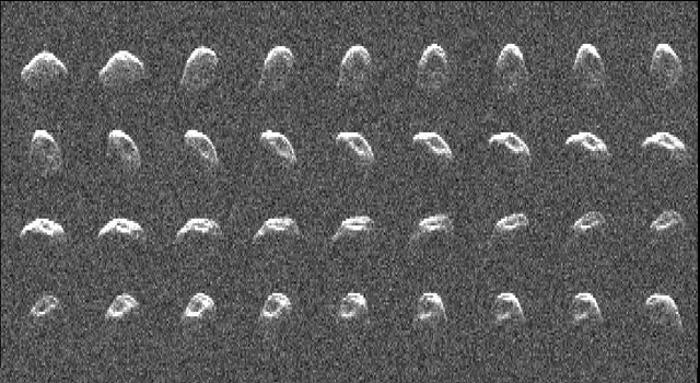
A radar image of asteroid 2010 JL33, generated from data taken by NASA's Goldstone Solar System Radar on Dec. 11 and 12, 2010. Image credit: NASA/JPL-Caltech
[/caption]
Intriguing details about the physical properties and characteristics of a recently discovered asteroid have just been unveiled in amazing images obtained using a large radar dish in California. The radar dish serves as a key component of NASA’s Deep Space Network (DSN). The Near Earth asteroid, dubbed 2010 JL33, was imaged by radar on Dec. 11 and 12, 2010 at NASA’s Goldstone Solar System Radar in California’s Mojave Desert when a close approach to Earth offered an outstanding opportunity for high quality science.
Asteroids studies have taken on significantly increased importance at NASA ever since President Obama decided to cancel the Constellation ‘Return to the Moon’ program and redirect NASA’s next human spaceflight goal to journeying to an Asteroid by around 2025.
Update: Orbital diagram added below
A sequence of 36 amazingly detailed images has been assembled into a short movie (see below) by the science team at NASA’s Jet Propulsion Laboratory (JPL) in Pasadena, Calif. The movie shows about 90 percent of one rotation.
The data gathered by radar revealed that the asteroid measures roughly 1.8 kilometers (1.1 miles) in diameter and rotates once every nine hours.
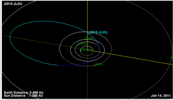
Orbital diagram of Asteroid 2010 JL33 shows location as of Jan 14, 2011. Credit: NASA
click to enlage all images
“Asteroid 2010 JL33 approached within 17 Earth-Moon distances [some 7 million km] in December 2010 and offered an outstanding opportunity to study it with radar,” said Lance Benner, a scientist at JPL who studies asteroids.
“To get detailed radar images, an asteroid must be close to Earth,” Benner told me, for Universe Today.
The object was only discovered on May 6 by the Mount Lemmon Survey in Arizona. The radar observations were led by a team headed by JPL scientist Marina Brozovic.
Video Caption: While safely passing Earth, NASA’s Goldstone Solar System Radar captured the rotation of asteroid 2010 JL33 — an irregular, elongated object roughly 1.8 kilometers (1.1) miles wide. The video consists of 36 frames.
“The radar images we got enabled us to estimate the asteroid’s size, rotation period, and to see features on its surface, most notably, the large concavity that appears as a dark region in the collage,” Benner elaborated.
“It was discovered so recently that little else is known about it.”
The object was revealed to be elongated and irregularly shaped.
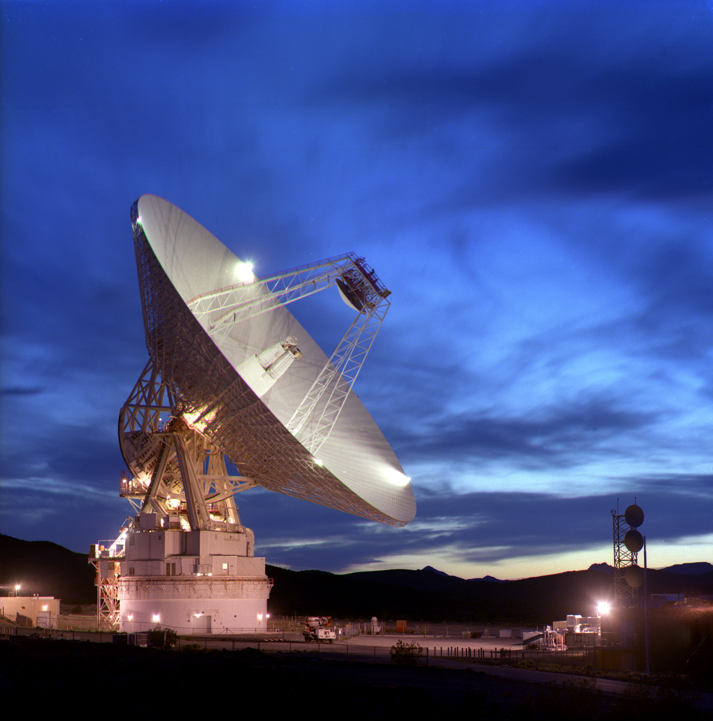
70-meter diameter NASA Deep Space Network (DSN) antenna at Goldstone, California.
The 70-meter (230-foot) diameter antenna is the largest, and therefore most sensitive, DSN antenna, and is capable of tracking a spacecraft travelling more than 16 billion kilometers (10 billion miles) from Earth.
The surface of the 70-meter reflector must remain accurate within a fraction of the signal wavelength, meaning that the precision across the 3,850-square-meter (41,400 sq. ft.) surface is maintained within one centimeter (0.4 in.). Credit: NASA
The large concavity is clearly visible in the images and may be an impact crater. It took about 56 seconds for the radio signals from the 70-meter (230-foot) diameter Goldstone radar dish to make the roundtrip from Earth to the asteroid and back to Earth again.
“When we get deeper into our analysis of the data, we will use the images to estimate the three-dimensional shape of the asteroid as well,” Benner added.
Benner belongs to a team that is part of a long-term NASA program to study asteroid physical properties and to improve asteroid orbits using radar telescopes at Goldstone and also at the Arecibo Observatory in Puerto Rico. The 1,000-foot-diameter (305 meters) Arecibo radar dish antenna is operated by the National Science Foundation.
“Each close approach by an asteroid provides an important opportunity to study it, so we try to exploit as many such opportunities as possible to investigate the physical properties of many asteroids. In the bigger picture, this helps us understand how the asteroids formed,” Benner told me.
“Asteroid 2010 JL33 is in an elongated orbit about the Sun. On average, it’s about 2.7 times farther from the Sun than the Earth is, but its distance from the Sun varies from 0.7 to 4.6 times that of the Earth.” That takes the asteroid nearly out to Jupiter at Aphelion. It takes about 4.3 years to complete one orbit around the sun.
But, there’s no need to fret about disaster scenarios. “The probability of impact with Earth is effectively zero for the foreseeable future,” Benner explained.
“On rare occasions it approaches closely to Vesta,” he said. Vesta is the second most massive asteroid and will be visited for the first time by NASA’s Dawn spacecraft later this year.
In addition to the ground based radar imaging, the tiny space rock was investigated by an Earth orbiting telescope.
“This asteroid was also studied by NASA’s Wide-field Infrared Survey Explorer (WISE) spacecraft,” according to Benner. “Our observations will help WISE scientists calibrate their results because we provided an independent means to estimate the size of this object.”
More at this JPL press release. The NASA-JPL Near-Earth Object Program website has an interactive map that allows you to see the asteroid’s position at any time you desire. Go to here
To see the trajectory of any other near-Earth asteroid, go to here
For more information about asteroid radar research, go to here
Check out this awesome pair of inspiring videos about NASA and Space Exploration. They are set to the ever inspiring words of Carl Sagan – reading from his book, “The Pale Blue Dot”. And these beautifully crafted videos were not created by NASA, but rather by people inspired by NASA and Carl Sagan to dream about distant frontiers even in these times of tough budgets for NASA.
The original, highly praised video – see below – was created by Director Michael Marantz, who was inspired by the words of Carl Sagan. Now a completely new version – above – by a fellow going by “damewse”, has been set to the same stirring words and music and the video has gone viral.
[/caption]
“damewse” posted that he created the new video treatment because he feels NASA’s PR sucks, resulting in massive funding cuts. He pleads with NASA to use social media to relate to the public with videos like these to rekindle public interest in the space program.
Both videos are included here for all to enjoy and compare – moving and thought provoking in their own right.
“damewse” elaborated; “I got frustrated with NASA and made this video. NASA is the most fascinating, adventurous, epic institution ever devised by human beings, and their media sucks.”
“Seriously. none of their brilliant scientists appear to know how to connect with the social media crowd, which is now more important than ever. In fact, NASA is an institution whose funding directly depends on how the public views them.”
Earth: The Pale Blue Dot
The original film and comments by Director Michael Marantz
“Carl Sagan provides the epic narration to this piece. His great ability to convey such overwhelming topics in relatable ways inspired me to make this.”
The Pale Blue Dot. Most distant image of Earth, snapped by the Voyager 1 spacecraft in 1990 at a distance of 6.1 billion kilometers. Credit: NASA
“This piece contains readings from Carl Sagan’s “Pale Blue Dot”. I have edited his words to tell this short narrative.
I took the time lapse images in Mexico and Utah.
The piano is self-composed.
Everything in this video is created by myself except for the words of Carl Sagan.
I hope you enjoy this piece, it has given me hope once again.”
– Michael Marantz
…………..
Well NASA does need to do a more effective job at PR to grab the attention of the public – especially the younger generations – and explaining the agency’s exploration goals in ways that folks will find value in and support. But it’s also true that NASA has embraced many forms of social media. Take a look at almost any NASA Center or Mission homepage and you’ll see buttons for Twitter, Facebook, YouTube, flickr, blogs and more. I’ve found these sources to be invaluable, especially during beaking news events.
It hinges more I think on the quality of the presentation of the content and the organization of outstanding material at those websites. Look here for a thoughtful perspective from Spaceref Canada
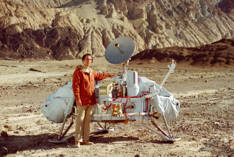
The lengthy list of exciting and worthy ideas and lost opportunities for space exploration that have gone unfunded in our lifetimes, is truly sad. Carl Sagan with a model of the Viking Lander that landed on Mars in 1976 in the search for life.


