Ceres Prank Lands Bart Simpson In Detention For Eternity

Do you see Bart Simpson's face on these surface features on Ceres? Researchers studying the surface of the dwarf planet for evidence of the presence of ice do. Credit: NASA/JPL-Caltech/UCLA/MPS/DLR/IDA, taken by Dawn Framing Camera

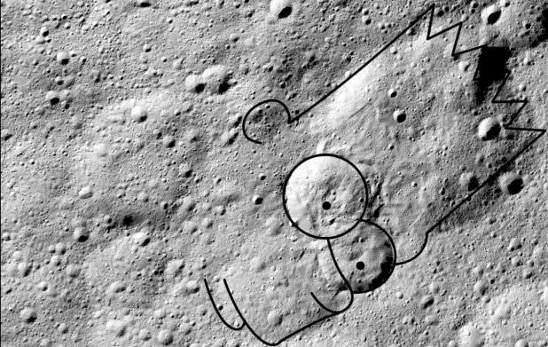
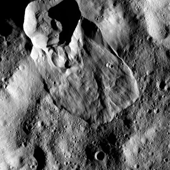
Human-kind has a long history of looking up at the stars and seeing figures and faces. In fact, there’s a word for recognizing faces in natural objects: pareidolia. But this must be the first time someone has recognized Bart Simpson’s face on an object in space.

Researchers studying landslides on the dwarf planet Ceres noticed a pattern that resembles the cartoon character. The researchers, from the Georgia Institute of Technology, are studying massive landslides that occur on the surface of the icy dwarf. Their findings are reinforcing the idea that Ceres has significant quantities of frozen water.

Dwarf planet Ceres is the largest object in the asteroid belt between Mars and Jupiter. Credit: NASA/JPL-Caltech/UCLA/MPS/DLR/IDA, taken by Dawn Framing Camera

In a new paper in the journal Nature Geoscience, the team of scientists, led by Georgia Tech Assistant Professor and Dawn Science Team Associate Britney Schmidt, examined the surface of Ceres looking for morphologies that resemble landslides here on Earth.

Research shows us that Ceres probably has a subsurface shell that is rich with water-ice. That shell is covered by a layer of silicates. Close examination of the type, and distribution, of landslides at different latitudes adds more evidence to the sub-surface ice theory.

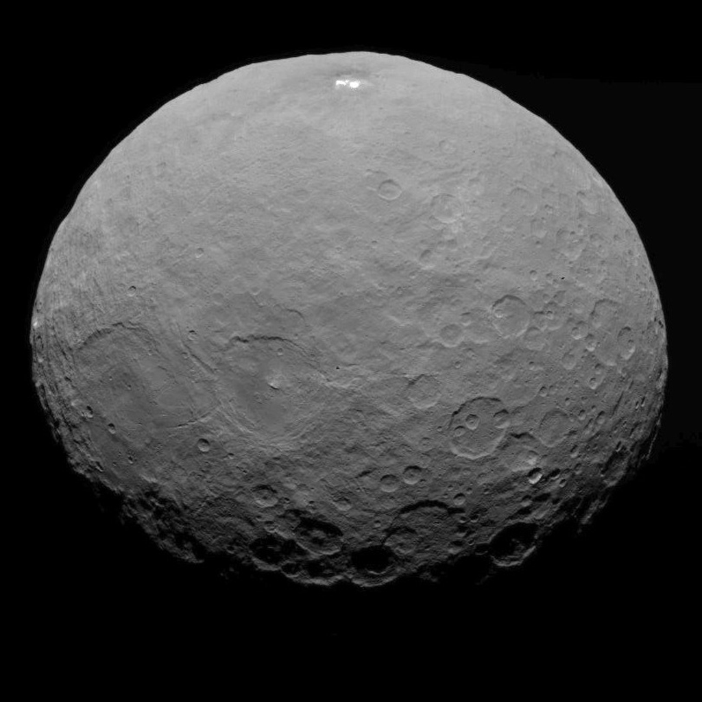
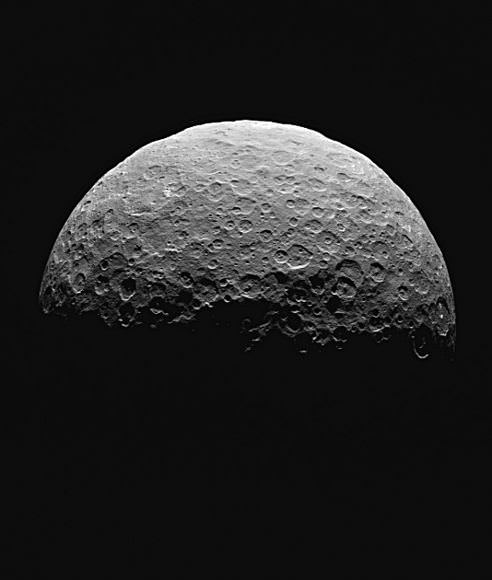
Ceres is pretty big. At 945 km in diameter, it’s the largest object in the asteroid belt between Mars and Jupiter. It’s big enough to be rounded by its own gravity, and it actually comprises about one third of the mass of the entire asteroid belt.

Credit: NASA/JPL-Caltech/UCLA/MPS/DLR/IDA, taken by Dawn Framing Camera
Type 1 landslides on Ceres are large and occur at higher latitudes. Image: Credit: NASA/JPL-Caltech/UCLA/MPS/DLR/IDA, taken by Dawn Framing Camera

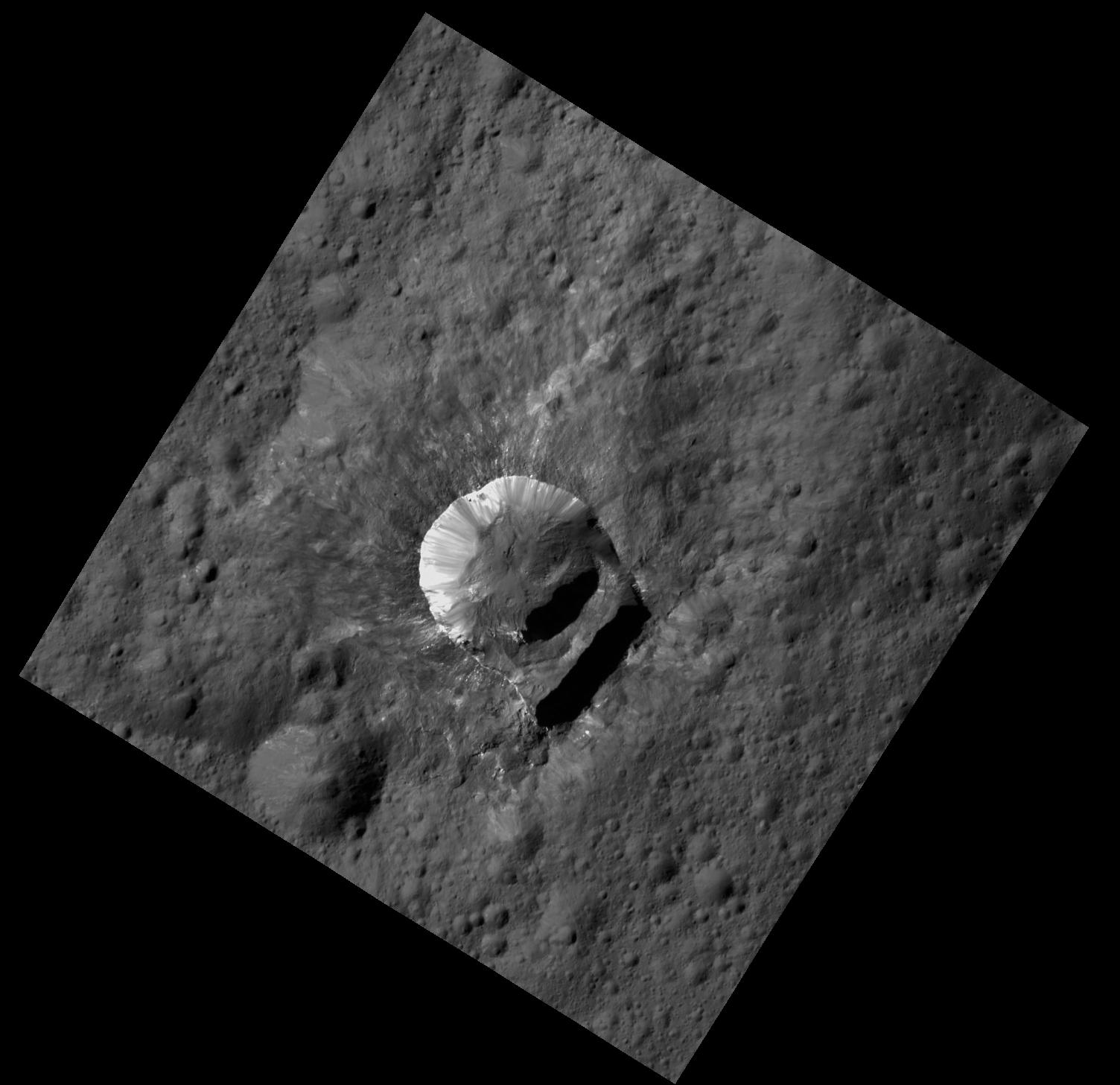
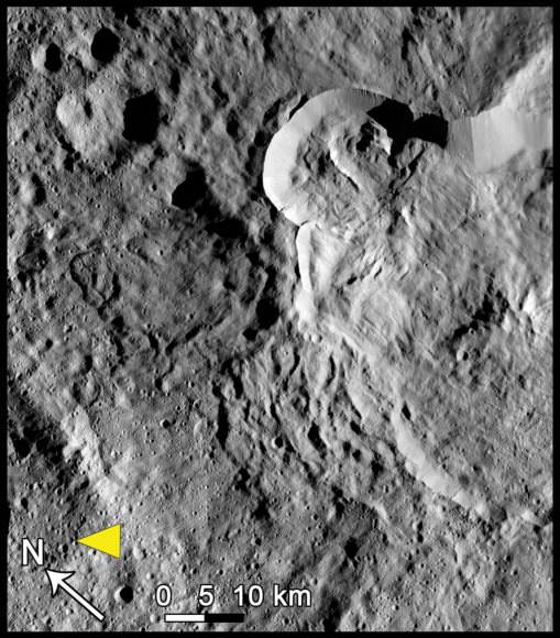
The team used observations from the Dawn Framing Camera to identify three types of landslides on Ceres’ surface:

  • Type 1 are large, rounded features similar to glacier features in the Earth’s Arctic region. These are found mostly at high latitudes on Ceres, which is where most of the ice probably is.
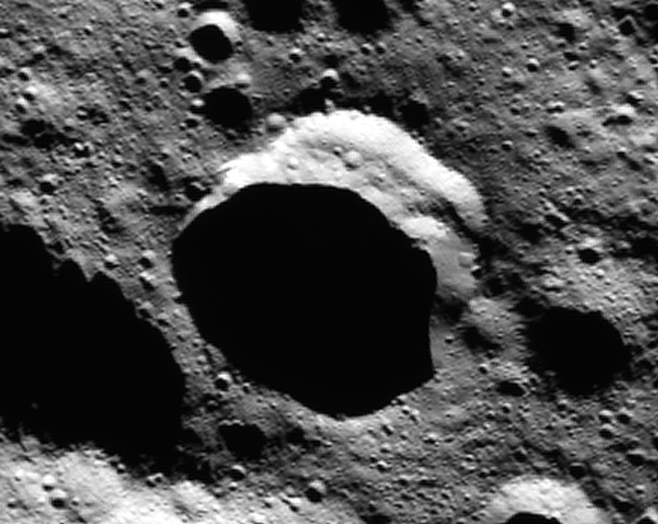
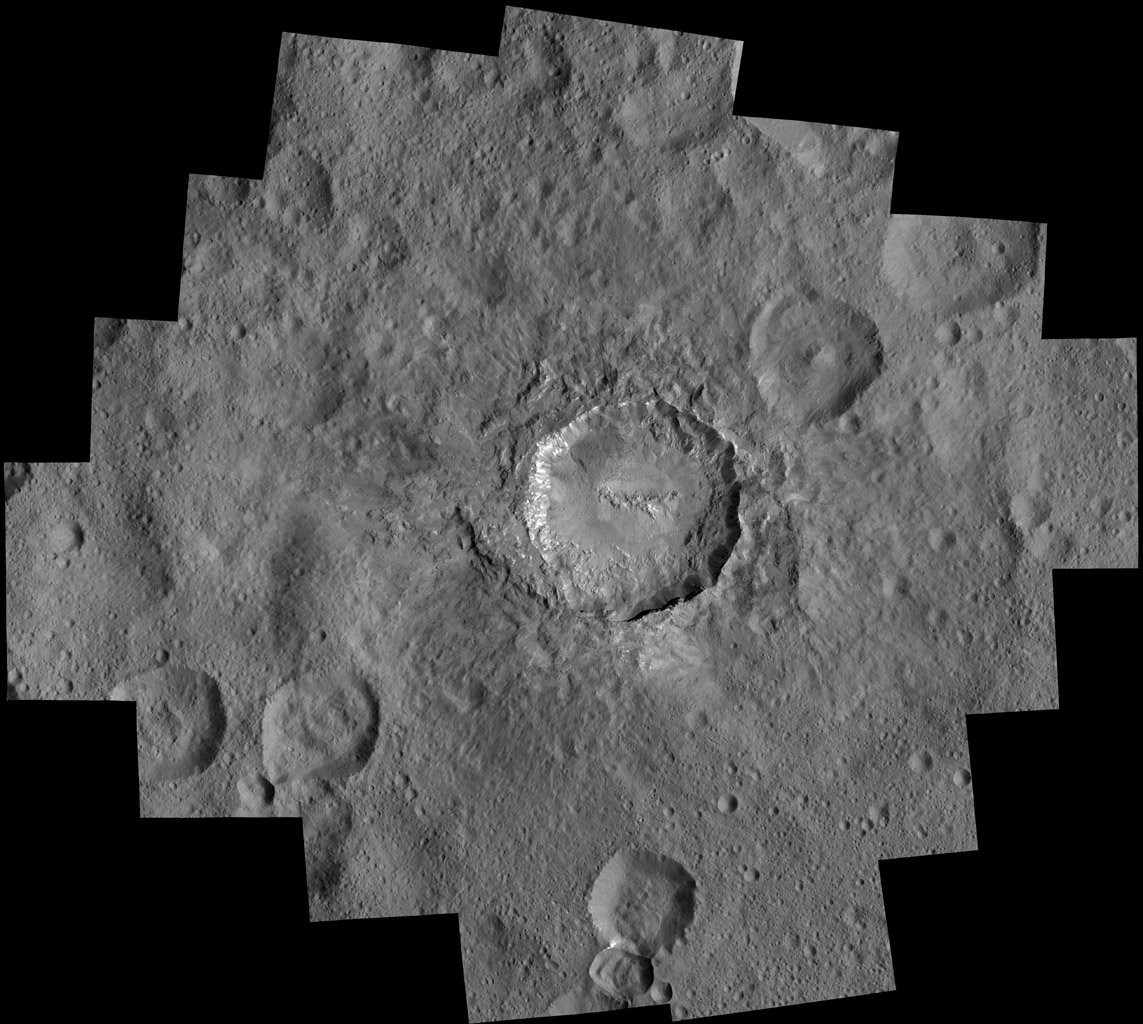
  • Type 2 are the most common. They are thinner and longer than Type 1, and look like terrestrial avalanche deposits. They’re found mostly at mid-latitudes on Ceres. The researchers behind the study thought one of them looked like Bart Simpson’s face.
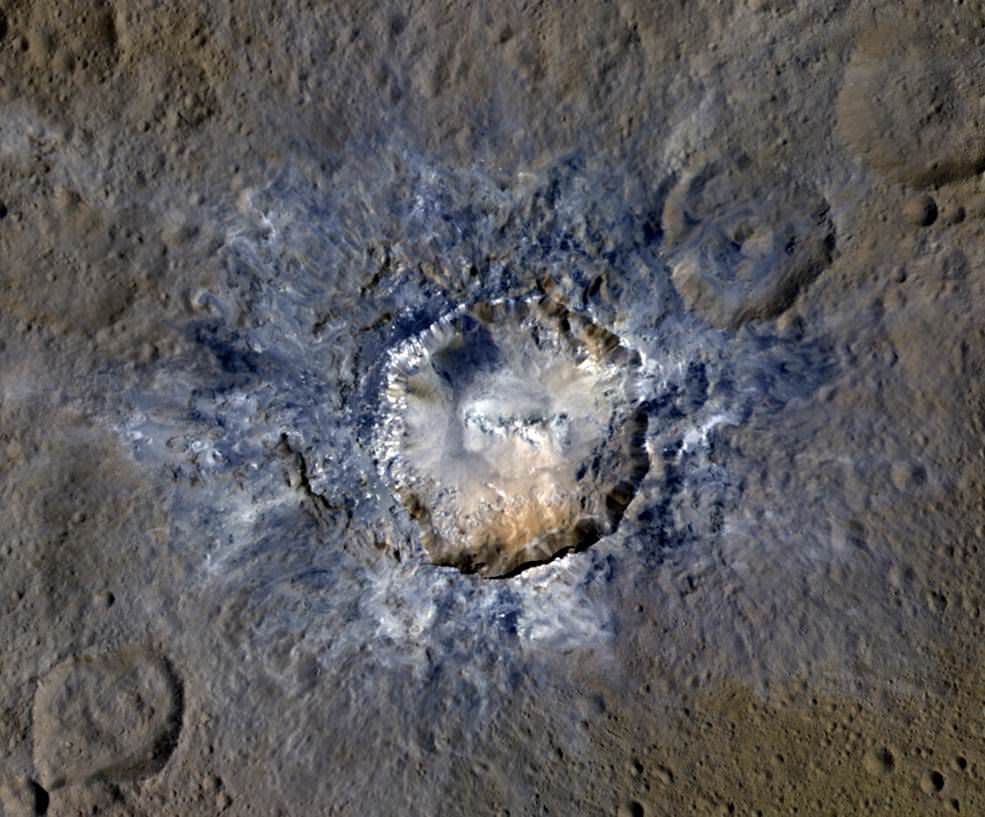
  • Type 3 occur mostly at low latitudes near Ceres’ equator. These are always found coming from large impact craters, and probably formed when impacts melted the sub-surface ice.
Type 3 landslides on Ceres occur at low latitudes at large craters, and form when ice is melted by impacts. Credit: NASA/JPL-Caltech/UCLA/MPS/DLR/IDA, taken by Dawn Framing Camera

The authors of the study say that finding larger landslides further away from the equator is significant, because that’s where most of the ice is.

“Landslides cover more area in the poles than at the equator, but most surface processes generally don’t care about latitude,” said Schmidt, a faculty member in the School of Earth and Atmospheric Sciences. “That’s one reason why we think it’s ice affecting the flow processes. There’s no other good way to explain why the poles have huge, thick landslides; mid-latitudes have a mixture of sheeted and thick landslides; and low latitudes have just a few.”  

Key to understanding these results is the fact that these types of processes have only been observed before on Earth and Mars. Earth, obviously, has water and ice in great abundance, and Mars has large quantities of sub-surface ice as well. “It’s just kind of fun that we see features on this small planet that remind us of those on the big planets, like Earth and Mars,” Schmidt said. “It seems more and more that Ceres is our innermost icy world.”

“These landslides offer us the opportunity to understand what’s happening in the upper few kilometers of Ceres,” said Georgia Tech Ph.D. student Heather Chilton, a co-author on the paper. “That’s a sweet spot between information about the upper meter or so provided by the GRaND (Gamma Ray and Neutron Detector) and VIR (Visible and Infrared Spectrometer) instrument data, and the tens of kilometers-deep structure elucidated by crater studies.”

It’s not just the presence of these landslides, but the frequency of them, that upholds the icy-mantle idea on Ceres. The study showed that 20% to 30% of craters on Ceres larger than 10 km have some type of landslide. The researchers say that upper layers of Ceres’ could be up to 50% ice by volume.

Ice, Ice Everywhere, says New Study on Ceres

This image of Ceres was taken by NASA's Dawn spacecraft on May 7, 2015, from a distance of 8,400 miles (13,600 kilometers). Credit: NASA/JPL-Caltech/UCLA/MPS/DLR/IDA

As the single-largest body in the Asteroid Belt, Ceres has long been a source of fascination to astronomers. In addition to being the only asteroid large enough to become rounded under its own gravity, it is also the only minor planet to be found within the orbit of Neptune. And with the arrival of the Dawn probe around Ceres in March of 2015, we have been treated to a steady stream of scientific finds about this protoplanet.

The latest find, which has come as something of a surprise, has to do with the composition of the planet. Contrary to what was previously suspected, new evidence shows that Ceres has large deposits of water ice near its surface. This and other evidence suggests that beneath its rocky, icy surface, Ceres has deposits of liquid water that could have played a major role in its evolution.

This evidence were presented at the 2016 American Geophysical Union meeting, which kicked off on Monday, Dec. 12th, in San Fransisco. Amid the thousands of seminars that detailed the biggest findings made during the past year in the fields of space and Earth science – which included updates from the Curiosity mission – members of the Dawn mission team shared the results of their research, which were recently published in Science.

This graphic shows a theoretical path of a water molecule on Ceres. Some water molecules fall into cold, dark craters called "cold traps," where very little of the ice turns into vapor, even over the course of a billion years. Credit: NASA/JPL-Caltech/UCLA/MPS/DLR/IDA
Graphic showing a theoretical path of a water molecule on Ceres. Some water molecules fall into cold, dark craters called “cold traps,” where very little of the ice turns into vapor, even over the course of a billion years. Credit: NASA/JPL-Caltech/UCLA/MPS/DLR/IDA

Titled “Extensive water ice within Ceres’ aqueously altered regolith: Evidence from nuclear spectroscopy“, the mission team’s study details how data gathered by Dawn’s Gamma Ray and Neutron Detector (GRaND) determined the concentrations of hydrogen, iron and potassium in Ceres crust. In so doing, it was able to place constraints on the planet’s ice content, and how the surface was likely altered by liquid water in Ceres’ interior.

In short, the GRaND instrument detected high levels of hydrogen in Ceres’ uppermost structure (10% by weight), which appeared most prominently around the mid-latitudes. These readings were consistent with broad expanses of water ice. The GRaND data also showed that rather than consisting of a solid ice layer, the ice was likely to take the form of a porous mixture of rocky materials (in which ice fills the pores).

Previously, ice was thought to only exist within certain cratered regions on Ceres, and was thought to be the result of impacts that deposited water ice over the course of Ceres’ long history. But as Thomas Prettyman – the principal investigator of Dawn’s GRaND instrument – said in a NASA press release, scientists are now rethinking this position:

“On Ceres, ice is not just localized to a few craters. It’s everywhere, and nearer to the surface with higher latitudes. These results confirm predictions made nearly three decades ago that ice can survive for billions of years just beneath the surface of Ceres. The evidence strengthens the case for the presence of near-surface water ice on other main belt asteroids.”

The concentrations of iron, potassium and carbon detected by the GRaND instrument also supports the theory that Ceres’ surface was altered by liquid water in the interior. Basically, scientists theorize that the decay of radioactive elements within Ceres created enough heat to cause the protoplanet’s structure to differentiate between a rocky interior and icy outer shell – which also allowed minerals like those observed to be deposited in the surface.

Similarly, a second study produced by researchers from the Max Planck Institute for Solar Research examined hundreds of permanently-shadowed craters located in Ceres’ northern hemisphere. According to this study, which appeared recently in Nature Astronomy, these craters are “cold traps”, where temperatures drop to less than 11o K (-163 °C; -260 °F), thus preventing all but the tiniest amounts of ice from turning into vapor and escaping.

Within ten of these craters, the researcher team found deposits of bright material, reminiscent to what Dawn spotted in the Occator Crater. And in one that was partially sunlit, Dawn’s infrared mapping spectrometer confirmed the presence of ice. This suggests that water ice is being stored in Ceres darker craters in a way that is similar to what has been observed around the polar regions of both Mercury and the Moon.

Where this water came from (i.e. whether or not it was deposited by meteors) remains something of a mystery. But regardless, it shows that water molecules on Ceres could be moving from warmer mid-latitudes to the colder, darker polar regions. This lends further weight to the theory that Ceres might have a tenuous water vapor atmosphere, which was suggested back in 2012-13 based on evidence obtained by the Herschel Space Observatory.

f images from NASA's Dawn spacecraft shows a crater on Ceres that is partly in shadow all the time. Such craters are called "cold traps." Credit: NASA/JPL-Caltech/UCLA/MPS/DLR/IDA
f images from NASA’s Dawn spacecraft shows a crater on Ceres that is partly in shadow all the time. Such craters are called “cold traps.” Credit: NASA/JPL-Caltech/UCLA/MPS/DLR/IDA

All of this adds up to Ceres being a watery and geologically active protoplanet, one which could hold clues as to how life existed billions of years ago. As Carol Raymond, deputy principal investigator of the Dawn mission, also explained in the NASA press release:

“These studies support the idea that ice separated from rock early in Ceres’ history, forming an ice-rich crustal layer, and that ice has remained near the surface over the history of the solar system. By finding bodies that were water-rich in the distant past, we can discover clues as to where life may have existed in the early solar system.”

Back in July Dawn began its extended mission phase, which consists of it conducting several more orbits of Ceres. At present, it is flying in an elliptical orbit at a distance of more than 7,200 km (4,500 mi) from the protoplanet. The spacecraft is expected to operate until 2017, remaining a perpetual satellite of Ceres until the end.

Further Reading: NASA, IfA, PSI

Landslides and Bright Craters on Ceres Revealed in Marvelous New Images from Dawn

Ceres' Haulani Crater, with a diameter of 21 miles (34 kilometers), shows evidence of landslides from its crater rim. Credits: NASA/JPL-Caltech/UCLA/MPS/DLR/IDA
Ceres' Haulani Crater, with a diameter of 21 miles (34 kilometers), shows evidence of landslides from its crater rim.  Credits: NASA/JPL-Caltech/UCLA/MPS/DLR/IDA
Ceres’ Haulani Crater, with a diameter of 21 miles (34 kilometers), shows evidence of landslides from its crater rim. Credits: NASA/JPL-Caltech/UCLA/MPS/DLR/IDA

Now in orbit for just over a year at dwarf planet Ceres, NASA’s Dawn spacecraft continues to astound us with new discoveries gleaned from spectral and imagery data captured at ever decreasing orbits as well as since the probe arrived last December at the lowest altitude it will ever reach during the mission.

Mission scientists have just released marvelous new images of Haulani and Oxo craters revealing landslides and mysterious slumps at several of the mysterious bright craters on Ceres – the largest asteroid in the main Asteroid Belt between Mars and Jupiter.

The newly released image of oddly shaped Haulani crater above, shows the crater in enhanced color and reveals evidence of landslides emanating from its crater rim.

“Rays of bluish ejected material are prominent in this image. The color blue in such views has been associated with young features on Ceres,” according to the Dawn science team.

“Enhanced color allows scientists to gain insight into materials and how they relate to surface morphology.”

Look at the image closely and you’ll see its actually polygonal in nature – meaning it resembles a shape made of straight lines – unlike most craters in our solar system which are nearly circular.

”The straight edges of some Cerean craters, including Haulani, result from pre-existing stress patterns and faults beneath the surface,” says the science team.

Haulani Crater has a diameter of 21 miles (34 kilometers) and apparently was formed by an impacting object relatively recently in geologic time and is also one of the brightest areas on Ceres.

“Haulani perfectly displays the properties we would expect from a fresh impact into the surface of Ceres. The crater floor is largely free of impacts, and it contrasts sharply in color from older parts of the surface,” said Martin Hoffmann, co-investigator on the Dawn framing camera team, based at the Max Planck Institute for Solar System Research, Göttingen, Germany, in a statement.

The enhanced color image was created from data gathered at Dawn’s High Altitude Mapping Orbit (HAMO), while orbiting at an altitude of 915 miles (1,470 kilometers) from Ceres.

Data from Dawn’s VIR instrument shows that Haulani’s surface is comprised of different materials than its surroundings.

“False-color images of Haulani show that material excavated by an impact is different than the general surface composition of Ceres. The diversity of materials implies either that there is a mixed layer underneath, or that the impact itself changed the properties of the materials,” said Maria Cristina de Sanctis, the VIR instrument lead scientist, based at the National Institute of Astrophysics, Rome.

Since mid-December, Dawn has been orbiting Ceres in its Low Altitude Mapping Orbit (LAMO), at a distance of 240 miles (385 kilometers) from Ceres, resulting in the most stunning images ever of the dwarf planet.

By way of comparison the much higher resolution image of Haulani crater below, is a mosaic of views assembled from multiple images taken from LAMO at less than a third of the HAMO image distance – at only 240 miles (385 kilometers) above Ceres.

Haulani Crater at LAMO. NASA's Dawn spacecraft took this mosaic view of Haulani Crater at a distance of 240 miles (385 kilometers) from the surface of Ceres.  Credits: NASA/JPL-Caltech/UCLA/MPS/DLR/IDA/PSI
Haulani Crater at LAMO. NASA’s Dawn spacecraft took this mosaic view of Haulani Crater at a distance of 240 miles (385 kilometers) from the surface of Ceres. Credits: NASA/JPL-Caltech/UCLA/MPS/DLR/IDA/PSI

Dawn has also been busy imaging Oxo Crater, which despite its small size of merely 6-mile-wide (10-kilometer-wide) actually counts as a “hidden treasure” on Ceres – because it’s the second-brightest feature on Ceres!

Only the mysterious bright region comprising a multitude of spots inside Occator Crater shine more brightly on Ceres.

Most importantly, Oxo Crater is the only place on Ceres where Dawn has detected water at the surface so far. Via VIR, Dawn data indicate that the water exists either in the form of ice or hydrated minerals. Scientists speculate that the water was exposed either during a landslide or an impact.

“Little Oxo may be poised to make a big contribution to understanding the upper crust of Ceres,” said Chris Russell, principal investigator of the mission, based at the University of California, Los Angeles.

The signatures of minerals detected on the floor of Oxo crater appears to be different from the rest of Ceres.

Furthermore Oxo is “also unique because of the relatively large “slump” in its crater rim, where a mass of material has dropped below the surface.”

Oxo Crater on Ceres is unique because of the relatively large "slump" in its crater rim.  The 6-mile-wide (10-kilometer-wide) Oxo crater is the second-brightest feature on Ceres.  Credits: NASA/JPL-Caltech/UCLA/MPS/DLR/IDA/PSI
Oxo Crater on Ceres is unique because of the relatively large “slump” in its crater rim. The 6-mile-wide (10-kilometer-wide) Oxo crater is the second-brightest feature on Ceres. Credits: NASA/JPL-Caltech/UCLA/MPS/DLR/IDA/PSI

Dawn is Earth’s first probe in human history to explore any dwarf planet, the first to explore Ceres up close and the first to orbit two celestial bodies.

The asteroid Vesta was Dawn’s first orbital target where it conducted extensive observations of the bizarre world for over a year in 2011 and 2012.

The mission is expected to last until at least later into 2016, and possibly longer, depending upon fuel reserves.

Dawn will remain at its current altitude at LAMO for the rest of its mission, and indefinitely afterward, even when no further communications are possible.

Stay tuned here for Ken’s continuing Earth and planetary science and human spaceflight news.

Ken Kremer