
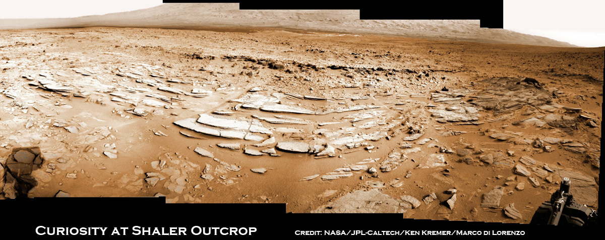
Image caption: Sol 120 colorized panorama of big and stunning ‘Shaler’ layered rock outcrop snapped by Curiosity’s right eye Navigation Camera (Navcam) on Dec. 7, 2012. ‘Shaler’ exhibits a pattern geologists refer to as ‘crossbedding’, at angles to one another. Some of the larger individual plates are about a foot or more wide. The cropped view spans from north at left to south at right. Future destination Mount Sharp is visible in the background. See the full 2-D panorama below and compare with the stereo effect available from NASA’s 3-D panorama, below. Credit: NASA/JPL-Caltech/Ken Kremer/Marco Di Lorenzo
NASA’s Curiosity rover is on the final steps of her descent into a geologist’s paradise at an area called ‘Yellowknife Bay’.
Along the way just days ago on Sol 120 (Dec 7, 2012) she stopped to inspect a huge outcrop of layered rocks dubbed ‘Shaler’ and snapped dozens of high resolution photos with the Navcam and Mastcam cameras.
To catch a human’s eye view of the breathtaking terrain of what some might hearken to an ‘unexpected journey’, check out our Sol 120 photo mosaic in 2-D (above) and then compare that with NASA’s 3-D photo mosaic (below). You will need to whip out you red-cyan anaglyph glasses to take in the full measure of Curiosity’s glorious surroundings and the foreboding shadow – can you guess what that is?
The ‘Shaler’ outcrop features a plethora of striking layers, angled to each other in a pattern geologists refer to as ‘crossbedding’.
The team also used Curiosity’s Chemistry and Camera (ChemCam) instrument on the rover’s mast to help assess the content of ‘Shaler.’
With the Christmas holidays fast approaching, the rover science team is searching for a suitable location at Yellowknife Bay to select as the first potential target to drill into with Curiosity’s advanced percussion drill.
Thereafter she will deliver powdered rock samples to the CheMin and SAM duo of miniaturized analytical chemistry labs on the rovers deck to elucidate the inorganic mineral composition as well as seek to determine if any organic molecules are present.

Image caption: Complete Sol 120 colorized panorama of big ‘Shaler’ layered rock outcrop snapped by Curiosity’s right eye Navigation Camera (Navcam) on Dec. 7, 2012. ‘Shaler’ exhibits a pattern geologists refer to as ‘crossbedding’, at angles to one another. The view spans from north-northwest at the left to south-southwest at the right. Study this full 2-D panorama and compare with the stereo effect available from NASA’s 3-D panorama, below. Credit: NASA/JPL-Caltech/Ken Kremer/Marco Di Lorenzo

Image caption: Sol 120 Stereo panorama of ‘Shaler’ rock outcrop snapped by the right and left eye Navigation Camera (Navcam) on Dec. 7, 2012. The view spans from north-northwest at the left to south-southwest at the right, and is presented in a cylindrical-perspective projection. Credit: NASA/JPL-Caltech
Yellowknife Bay lies within the place dubbed ‘Glenelg’, the rovers first major science destination. Glenelg uniquely sits at the junction of three different types of intersecting geologic features that will help unravel the mysteries of Curiosity’s Gale Crater touchdown zone beside a humongous mountain known as Mount Sharp – the main target of the mission.
After safely surviving the harrowing touchdown at ‘Bradbury Landing’ on Aug. 6, the SUV-sized Curiosity rover has been on a roll to reach the inviting interior terrain of ‘Glenelg’ before Christmas.
The six wheeled robot has thus far traversed more than 0.37 mile (598 meters) and is now driving on top of the most challenging and scientifically rewarding terrain of the entire four month journey.
“The rover is traversing across terrain different from where it has driven earlier, and responding differently,” said Rick Welch, mission manager at NASA’s Jet Propulsion Laboratory, Pasadena, Calif. “We’re making progress, though we’re still in the learning phase with this rover, going a little slower on this terrain than we might wish we could.”
Curiosity will spend at least several weeks thoroughly investigating Yellowknife Bay before reversing course and setting out on the year-long 6 mile (10 km) trek to the lower reaches of Mount Sharp. Along the way, the science team may possibly choose to re-investigate the Shaler and Hottah outcrops with the rover’s suite of 10 state-of-the-art science instruments.

Image caption: Curiosity Traverse Map, Sol 123 (Dec. 10, 2012). This map traces where NASA’s Mars rover Curiosity drove between landing at a site named ‘Bradbury Landing,’ and the position reached during the mission’s 123rd Martian day, or sol, (Dec. 10, 2012) at ‘Yellowknife Bay’ inside the place called ‘Glenelg’. Credit: NASA/JPL-Caltech/Univ. of Arizona
It’d be interesting to see this intrepid machine plucking along over this uneven terrain to get a better idea of how it’s six wheeled mechanism responds to the bumpy drive… GO CURI!
Oh wow! Missing the thick alluvial fan of Peace Vallis which we later heard was likely billions of years old, I thought a good attempt to find organics before the Gale mound were missed in the name of the larger goals.
But cross-beddings seems to be a good sign of alluvial sediments:
“This is a case in geology in which the original depositional layering is tilted, and the tilting is not a result of post-depositional deformation. …
Cross bedding forms during deposition on the inclined surfaces of bedforms such as ripples and dunes, and indicates that the depositional environment contained a flowing fluid (typically, water or wind). …
Repeated avalanches will eventually form the sedimentary structure known as cross-bedding, with the structure dipping in the direction of the paleocurrent.”
Since Curiosity has been treading on water deposited sediments up to this point, it is likely these cross-beddings are from water rather than wind. Moreover, they would be excellent traps for the organics within the flows that came out of the alluvial fan deposit area to make them, I take it.
At least we can hope for so much carbon this time that we can distinguish between exogenous earthly sources and indigenous martian.
WOW! It’s hard to compare HiRise images and surface features.. to my untrained eye anyway. The HiRise images can only begin to suggest the actual terrain. Yeah.. I’d go slow!