NASA Satellite Sees Ghostly Remains of Vanishing Arctic Sea Ice
Sea ice swirls in ocean currents off the coast of Greenland (NASA/GSFC)
Spooky spectral swirls of last season’s sea ice drift in currents off the coast of eastern Greenland in this image from NASA’s Aqua satellite, acquired on October 17. Although sea ice in the Arctic will start forming again after September’s record low measurements, these ghostly wisps are likely made up of already-existing ice that has migrated south.
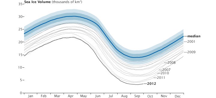
As global temperatures rise — both over land and in the ocean — thinner sea ice builds up during the Arctic winter and thus more of it melts during the summer, a pattern that will eventually lead to an ice-free Arctic if trends continue. The past several years saw sea ice in the Arctic below the 1979-2000 average, with this past September displaying the lowest volumes yet recorded.
The graph below, made from data modeled by the Polar Science Center at the University of Washington, show the chilling — or, perhaps, not-so-chilling — results of this century’s recent observations.
Along Greenland’s east coast, the Fram Strait serves as an expressway for sea ice moving out of the Arctic Ocean. The movement of ice through the strait used to be offset by the growth of ice in the Beaufort Gyre.
Until the late 1990s, ice would persist in the gyre for years, growing thicker and more resistant to melt. Since the start of the twenty-first century, however, ice has been less likely to survive its trip through the southern part of the Beaufort Gyre. As a result, less Arctic sea ice has been able to pile up and form multi-year ice.
Thin, free-drifting ice — as seen above — moves very easily with winds and currents.
Aqua is a NASA Earth Science satellite mission named for the large amount of information that the mission is collecting about the Earth’s water cycle, including evaporation from the oceans, water vapor in the atmosphere, clouds, precipitation, soil moisture, sea ice, land ice, and snow cover on the land and ice. Aqua was launched on May 4, 2002, and carries six Earth-observing instruments in a near-polar low-Earth orbit. MODIS, which acquired the image above, is a 36-band spectroradiometer that measures physical properties of the atmosphere, oceans and land.
Source: NASA Earth Observatory
NASA image courtesy Jeff Schmaltz, LANCE MODIS Rapid Response Team at NASA GSFC. Graph by Jesse Allen based on modeled ice volume data from the Polar Science Center, University of Washington. Caption portions by Michon Scott with information from Ted Scambos, National Snow and Ice Data Center.
Recent Posts
Purple Bacteria — Not Green Plants — Might Be the Strongest Indication of Life
Astrobiologists continue to work towards determining which biosignatures might be best to look for when…
See the Southern Ring Nebula in 3D
Planetary nebula are some of nature's most stunning visual displays. The name is confusing since…

Hubble Has Accidentally Discovered Over a Thousand Asteroids
The venerable Hubble Space Telescope is like a gift that keeps on giving. Not only…
NASA Restores Communications with Voyager 1
The venerable Voyager 1 spacecraft is finally phoning home again. This is much to the…
Will We Know if TRAPPIST-1e has Life?
The search for extrasolar planets is currently undergoing a seismic shift. With the deployment of…
Astronaut Food Will Lose Nutrients on Long-Duration Missions. NASA is Working on a Fix
Astronauts on board the International Space Station are often visited by supply ships from Earth…