
Images from the Curiosity rover on Mars are truly spectacular but a large mosaic from the THEMIS camera aboard NASA’s Mars Odyssey orbiter gives a grand perspective of our new foothold on Mars. Take some time to rove and explore Gale Crater.
The viewer, created using a web-imaging technology from Zoomify, is set to move between points of interest, such as Mars Science Laboratory’s landing site in Aeolis Palus, Glenelg, and Aeolis Mons/Mount Sharp itself. The layered sediments flanking Mount Sharp make it the primary target for Curiosity’s two-year mission. Take control at anytime by clicking on the image. This will stop the automatic roving and leave you in control to explore the terrain of Gale Crater. Use your mouse or the toolbar controls to pan and zoom around the image. You can also use the dropdown in the upper right to take you directly to certain points of interest in the image. Over time, we will add to this interactive feature as more geological points of interest are identified.
THEMIS stands for Thermal Emission Imaging System which is a multiband visible and infrared camera aboard Odyssey. The comprehensive mosaic is pieced together from 205 individual scenes, most taken recently but some dating to 2002 shortly after Odyssey entered Mars orbit in 2001. These images were taken before MSL landed on Mars. Even so, as large as the SUV-sized rover is, it would be too small to see in these images. The smallest details in this image are 18 meters or 60 feet across.
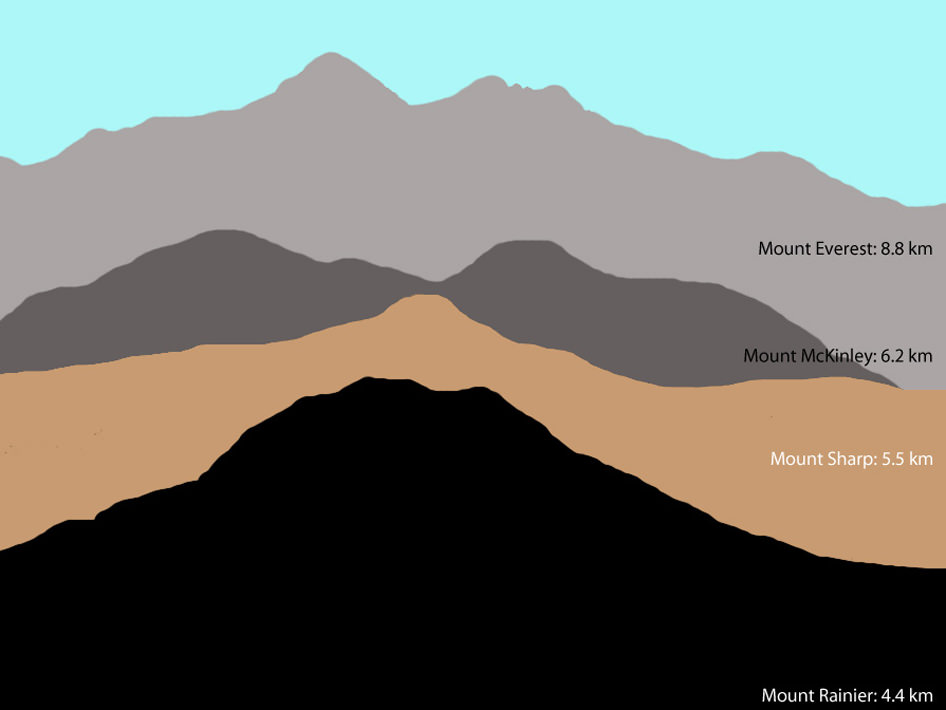
This illustration shows the size of Aoelis Mons (Mount Sharp) in comparison to three large mountains on Earth. The elevation of Mount Sharp is given in kilometers above the floor of Gale Crater. The heights of the Earth mountains are given in kilometers above sea level. Image credit: Tanya Harrison, NASA/JPL-Caltech/MSSS
Gale Crater is 154 kilometers (96 miles) wide. Near the center rises Aeolis Mons, a 5 km (3 mile) high mound of layered sediments, informally dubbed Mount Sharp, after planetary geologist Robert Sharp who died in 2004. Scientists for a time referred to the conical mountain as “The Mound.” The mountain, which would stand among the highest on Earth, cannot be seen from Earth and was unknown before planetary probes visited the Red Planet.
“The reason we decided to assemble such a large, comprehensive mosaic of Gale Crater was to give ourselves a better sense of the context around the landing site, said Jonathon Hill, a Mars research at Arizona State University who assembled the mosaic, a press release. “This will help us to better understand what Curiosity sees and measures as it roves the surface.”
Gale Crater zoom tour created by John Williams (TerraZoom) using Zoomify.
About the author: John Williams is owner of TerraZoom, a Colorado-based web development shop specializing in web mapping and online image zooms. He also writes the award-winning blog, StarryCritters, an interactive site devoted to looking at images from NASA’s Great Observatories and other sources in a different way. A former contributing editor for Final Frontier, his work has appeared in the Planetary Society Blog, Air & Space Smithsonian, Astronomy, Earth, MX Developer’s Journal, The Kansas City Star and many other newspapers and magazines.
Seems you are on top of this visualization. Very nifty.
They found a route round most or all of those pesky sand dunes. Go, Curiosity!
This just keeps getting better and better. This is massive amounts of fun!
Nice to see some agreement on the use of Aeolis Mons/Mount Sharp.
Aeolis Palus or Aeolis Pavus? Seems that Palus is correct (http://planetarynames.wr.usgs.gov/Feature/15001) – bothersome typos!