
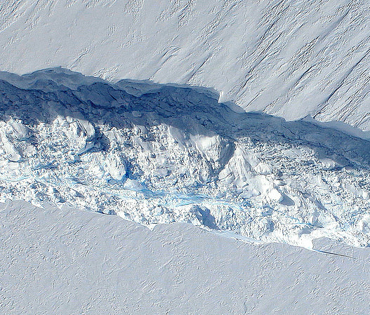
Data collected from a NASA ice-watching satellite reveal that the vast ice shelves extending from the shores of western Antarctica are being eaten away from underneath by ocean currents, which have been growing warmer even faster than the air above.
The animation above shows the circulation of ocean currents around the western Antarctic ice shelves. The shelf thickness is indicated by the color; red is thicker (greater than 550 meters), while blue is thinner (less than 200 meters).
Launched in January 2003, NASA’s ICESat (Ice, Cloud and land Elevation Satellite) studied the changing mass and thickness of Antarctica’s ice from its location in polar orbit. An international research team used over 4.5 million surface height measurements collected by ICESat’s GLAS (Geoscience Laser Altimeter System) instrument from Oct. 2005 to 2008. They concluded that 20 of the 54 shelves studied — nearly half — were losing thickness from underneath.
[/caption]
Most of the melting ice shelves are located in west Antarctica, where the flow of inland glaciers to the sea has also been accelerating — an effect that can be compounded by thinning ice shelves which, when grounded to the offshore seabed, serve as dams to hold glaciers back.
Melting of ice by ocean currents can occur even when air temperature remains cold, maintaining a steady process of ice loss — and eventually increased sea level rise.
“We can lose an awful lot of ice to the sea without ever having summers warm enough to make the snow on top of the glaciers melt,” said Hamish Pritchard of the British Antarctic Survey in Cambridge and the study’s lead author . “The oceans can do all the work from below.”
The study also found that Antarctica’s winds are shifting in response to climate change.
“This has affected the strength and direction of ocean currents,” Pritchard said. “As a result warm water is funnelled beneath the floating ice. These studies and our new results suggest Antarctica’s glaciers are responding rapidly to a changing climate.”
ICESat completed operations in 2010 and was decommissioned in August of that year. Its successor ICESat-2 is anticipated to launch in 2016.
Read more on NASA’s news release here.
Animation credit: NASA/Goddard CGI Lab
Looks like Atlantis is rising!!
okokok… Let’s see…
Water is warming the ice from below. Wellll then, I guess we now have to eradicate under water vents…. “ALMOST half” (oopss note to readers— actually just over a third but what’s facts right???) “are melting”…what’s the situation on the other 63% (egads!!! well over half???)… Climate SENSATIONALISM has run amok on UT.
I could poke more holes in this effort than the Ozone but you know, I gotta actually earn a living.
Ahhh heck, I can’t help myself…
Basing this “science’ on a satellite launched in 2003 and its measurements up through 2008 gives ZERO credibility to the state of the climate, which we ALLLLL know is based on long term time frames… like millenia (you know what that means riggghtt? multiple of thousands?). Yet we want to discern what 50-100 years really means as far as climate. And 5 YEARS make what??? What does it make? Actually based on time, it probably is the equivalent of the starting twitch in the process of blinking an eye.
Now hold on, here’s the BIIIIG one. So big in fact that there’s two parts to it…
If this was sooooooooo huge and great and important, why is the replacement going to be launched in 2016, a full 6 years after the other one was decommissioned, with (YIKES) 6 years or more of missing data??? By goodness Antarctica might be in my glass of TWO if By TEA!!!!… and BTW, what did the 2009-2010 data show????
Damnnn and I’m a stoopid bible clingin’, gun totin’ common man. Imagine what someone ‘truly’ intelligent could do to this article.
Whattajoke.
These blog entries always bring the most intellectually challenged out of the woodwork. Your statement here are pure rubbish.
LC
Nice, Crowell. Tell me then, King-of-all-that-is-certain, Climate is defined as what?
Second, He points out that 20 of 54 (his words, “almost half”) mathematically is 37% (Math IS a science..yes?) Isn’t 37 closer to 33 which is a THIRD and NOT half? Or are you just rounding up because its over??
Thus the remaining 34 (THIRTY FOUR) in the equation is closer actually to two thirds and thus collapses his argument from the weight of its own agenda?
The ONLY contention you could have is the point I made about the launch of the replacement satellite in 2016.
Well, I still have time left during this coffee break for coffee…
If bloggists are going to be taken seriously and post assertions, they need to quote evidence, site works, and be freeking honest. If, as you contend, this AGW is world altering and undeniable, then when new evidence is sited, site the entire report and link it. But to call 20 out of 54 ‘almost half” and not mention what happened to the other areas and what their condition was and what happened in 2009-2010, it seems the article might have be gleaned from a specific viewpoint instead of objective and informational purposes.
Now, it seems that this “intellectually challenged” fool gave a bit more effort than thou….
Damn that was hot Joe.
you sound so stupid with these idiotic statements. What first grade education was enough for ya?
I’ll let your intellectually awesome post stand for itself.
Don’t let ’em get to you, Todd. Some folks just can’t stand honest discussion of a topic.
I didn’t, there are hidden messages in my post above.
What you write here is irrelevant to the main conclusion.
LC
LOL…The main conclusion is that “nearly half” of the shelves are being undermined by ocean currents… My point is that its barely over a third and what about the overwhelming majority of other shelves…Pretty pertinent to the article.
Two minutes with wikipedia is enough to ascertain that ICESat was launched on Jan 13 2003, and was retired in Feb 2010.
ICESat was designed to operate for three to five years.
Testing indicated that each of the GLAS LASERs should have lasted for two years.
A different component, however, failed during the initial on orbit test operation. Subsequent investigations indicated it was an unexpected, but known corrosive reaction between the gold wires and indium solder.
The operational plan was changed, the last LASER failed on 11 October 2009, and ICESat re-entered the earths atmosphere on August 30 2010.
ICESat-2 is scheduled for launch in 2016, however to fill the gap NASA has operation IceBridge.
Operation IceBridge used a DC-8 between March 2009 and some time in 2010. In 2010 they switched to a P-3 Orion.
The aircraft uses a LASER altimeter, a gravimeter, and several other pieces of equipment (a vegetation imaging sensor, a RADAR depth sounder, a snow RADAR, and a RADAR altimeter).
The advantage the aircraft has over the satelite is it can carry more instrumentation, however the advantage the satelite has over the aircraft is that it can cover a wider area.
I use Wiki too.. .didn’t this time… but as I’ve discovered and have come to understand, Wiki is not an infallible source and not really regarded as a bastion of fact due to it’s very nature.
While that is the case in some cases, I am sure what you’ve posited in the post above is accurate. Thanks for the inclusion of the DC-8 and P-3.
I was just after the whole story, and I thought the condition of the 67% other shelves deserved some sort of explanation.
ok, yes, “nearly half” is more hyperbolic than “over a third”, but that is still significant.
You cannot conclude from the article that the remaining 63% are gaining thickness
Thank you Ray….. That’s my point. We can’t because the information is absent in this post. But, we can surmise that if it pertained to the gist of the article, the condition of the 63% percent of the shelves would have made it INTO the post.
These blog entries always bring the most intellectually challenged out of the woodwork. Your statement here are pure rubbish.
LC
20 of 54 is not “nearly half”. It is 37%, which is much closer to a third than half.
If you’re working in halves, it’s nearer to a half than not-a-half. It was a pointless translation, but it’s just as pointless to argue over it. The figures are right there!