
[/caption]
Mars could be considered a spacecraft graveyard. The planet is just a hard place to get to – and especially land on — and there are several ‘lost’ spacecraft lying somewhere on Mars’ surface. The Soviet Mars 6 lander arrived at Mars on March 12, 1974. The records detail that the descent module entered the atmosphere and the parachute opened at 09:08:32 UT, and during that time, the craft was collecting and returning data. However, contact with the descent module was lost at 09:11:05 UT, about the time it was expected to reach the surface.
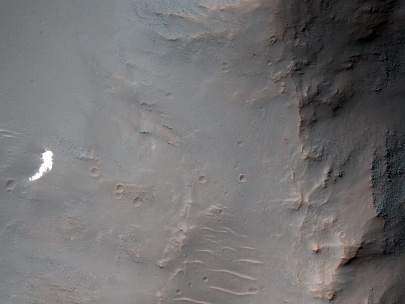
“Because we know that the parachute opened and have some idea where it was headed, we have a chance of locating the hardware on the surface with HiRISE,” said Alfred McEwen, principal investigator for HiRISE, the High Resolution Imaging Science Experiment camera on board the Mars Reconnaissance Orbiter.
And it may be in this image, as it would be in approximately the right region of where Mars 6 was supposed to land. In fact, hopes were raised when an anomalous small bright patch was seen by MRO’s Context Camera (CTX) team, and then a CTX team member suggested this area as a target for HiRISE.
McEwen said that since bright parachutes were the easiest thing to spot on the ground at 5 of the 6 past successful landing sites, but as you can see in this subimage, the bright spot at full HiRISE resolution appears to be just “a patch of relatively bright bedrock, with a pattern of thin lines (fractures) typical of such outcrops.”
But after nearly 38 years, the parachute and hardware may be covered by dust and look much like natural features on Mars.
“We’ll keep trying to find this and other failed landers,” McEwen said, “but there is a lot of surface area to cover on Mars.”
So, lend a hand and take a closer look by checking out the full resolution images available on the HiRISE website.
Ooh! There it is, right next to the rock in the sand.
Can someone help me with sun incidence angle? HiRISE observation toolbox claims Solar incidence angle is at 61°, but with respect to what? Pillars on the right side of the picture clearly suggest 10 o’clock position. Yeah, I know it’s presumptuous to look for it even after HiRISE people didn’t locate it – but I’m too of a geek not to check it out. 😉
What makes you think that UP is North 😉
I think they mean that the sun is 61 degrees above the horizon.
Because they say: Map projected scale: 25 cm/pixel and *North is up*. Although, I admit that is probably false (look at the map). Also, Sun is 29° above horizon (again, explicitly) and it is obvious that 61° is azimuth-like number but it is not clear with respect to what.
Think I found it! Enlarge the photo all the way, follow the footprints out of the fifth crater, and you’ll see a small area of disturbed ground. The return footprints show something being dragged back into the crater.
How many toes do the footprints have?
Hard to really be certain at that resolution, looks like 3 toes to me though.
What I am missing here is a sense of scale.
Below left, under the left bright spot, you can find something square like.
That’s a pixel. 😉
Very difficult, but catches my attention the “rocks” bright that are in the right corner
http://twitpic.com/8lbc07/full
I was looking at that same spot. It definitely sticks out.
If you consider that Mars 6 lander was roundish with four petals that unfolded and a package of some type on the top and seems to be shiny. Lower the overall image brightness and sharpen the image, THEN look at the base of the bright area where it tapers off to the lower portion. There is a small circular shape with a square center and rectangular edges, which could be the petals that have unfolded.
That lander and others could have easily been ‘swallowed up’ by landing in a dust pit? That is to say, fluffy dusty icy pockets meters deep – deep enough to bury the transmitting antenna? We assumed that might happen to the first lunar landers back in the 60’s. Mars has all the ingredients for that to actually happen…… Plop… Poof
You are so genius Readerabc because you found it!