Satellites Could Help Predict Landslides
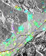
Using satellite data, scientists think they might have a way to give some advance warning of landslides, which kill hundreds of people around the world every year. Scientists know that regions which are about to turn into a landslide can shift slightly. Local observers would never notice a few millimeters of movement, but it's possible for satellites to track it from space using a technique called radar interferometry. Analysts compare multiple images of the same location which allows them to highlight regions which have shifted slightly.
Fraser Cain