
Image credit: NASA/JPL
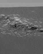
The first impression of the Opportunity landing site in color is the light, exposed area about ten meters from the rover’s location inside a crater. The region has by now accumulated a plethora of adjectives and names: bizarre, alien, hummocky, layered, crater-rim, outcrop, stratigraphic slice, tabular, segmented, slabby.
But what has scientists most intrigued is that the slabs are bedrock. The literal foundation of Mars is its bedrock. Bedrock is the solid, intact part of the planet’s crust. Whereas in comparison to terrestrial crust, parts of southern Arizona or Louisian may have thousands of feet of unconsolidated surficial material overlying bedrock, the depth to bedrock in a place like Maine ranges from ten to only a few hundred feet. Many of the more spectacular sites in Maine feature rugged bedrock exposed to view. To find bedrock is to know geologically that the history of this location is free from rock and boulder transport, mainly by wind, water, lava and impact debris.
Whatever happened on Mars over billions of years, that hummocky slab bears its records.
Steve Squyres, principal investigator for rover science, described the five exploration stages likely to follow in the next few weeks.
While still perched on its base petal, the rover cameras will first snap panoramic color images in octets of 45 degrees each, until a full picture shows the surroundings. Without driving, the rover’s pancam can probably get a good idea of the soil and rock surface composition, using its infrared capabilities to image circular aspects of the horizon in heat-sensitive colors. Called the mini-TES instrument, the main tool for this measures thermal emissions.
The mobile laboratory will then drive off its station, maneuvering down a ramp and 40 cm drop (slightly more than a foot). The rover will look at the fine soil nearby, in hopes of finding out why this particular region is rare on Mars in being rich with iron-oxides. The surface soil’s top layer is grey, much more grey than anything seen on Mars before. On the surface, Meridiani is the darkest color yet visited.
But this dark layer gave way when the airbags were retracted revealing a deep maroon layer underneath. When summarizing the science activities by discipline, Steve Squyres noted that most of the group members–atmospherics, long-term planning, mineralogy, geology–are not fully engaged until the instrument suite is checked out and deployed on the surface. But “the soil physical properties group is having the most fun” speculating about how this maroon and grey landform came to be. Squyres described the competing theories as either “we have soil with two distinct components of coarse, grey grains on top of fine red soil–or we have aggregates that are grey but when squished, the red comes out.
When certified to drive, the rover will explore the bedrock outcrop, while looking carefully for any layers or stratigraphic history. Since the rover is inside a crater (20 meters wide, 2-3 meters deep), the next step is probably to climb out. Depending on the soil texture, the rover is probably able to climb an embankment at a relatively steep 15 to 20 degree angle. As Squyres remarked: “We traveled 200 milllon miles or so to land in a crater. It was a hole-in-one.”
Since orbital images of the landing area shows three distinct color gradations, a first guess is that once outside this crater, the view will suddenly change to what is expected to be lighter colored soil. The brightest areas seen orbitally are the crater rims, followed by the flat plains, then the darkest interior to the craters, where Opportunity now is snapping charcoal-grey scenery. Since the horizon’s range is mainly restricted to 10 meters for now, once outside this crater the startling picture of a dark grey Mars will likely change yet again.
This second soil unit is brighter, perhaps from wind not apparent inside the craters, and will be looked at closely using the same diagnostics used on the crater floor and outcrop.
Squyres said the science team then looks to “head for the big one”–a 150 meter wide crater, probably 10-15 meters deep at least and about half-a-mile away. The bright rim of that crater may well be another remnant of bedrock or something different altogether.
How that driving spree will go looks promising so far. As pancam science lead, Jim Bell, described, where they can barely glimpse the horizon, it is flat and free of large rocks for five to six kilometers. This kind of “flat-out” driving terrain makes for fewer maneuvers to go the distance.
Once they survey the real Meridiani plain outside their crater, they will gain some higher ground–about the height of an average person of five to six feet climbing out of a hole of similar depth.
As JPL Center Director, Charles Elachi, pointed out on the night when Spirit first landed, the unique part of these missions is their multiplicity–not only two views of opposite sides of the planet, but also local mobility in which each science day that involves driving is comparable to a new landing. In 1976 Viking could only reach out and scratch the soil surface. The tiny Pathfinder rover could move between larger boulders, but had limited range. The Mars Exploration Rovers, with their mobile geology toolkit, are designed for the road.
Original Source: Astrobiology Magazine