
Image credit: NASA
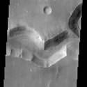
Now in its final orbit, Mars Odyssey is getting to work searching for water on the surface of the planet. The most recent set of images returned are of a network of channels taken by the Thermal Emission Imaging System (THEMIS). The Nirgal Vallis is a channel 500 km long and 6 km wide at this point – astronomers believe that gullies on the side of the channel were formed when water erupted to the surface.
This THEMIS image shows a sinuous valley network channel with sharp bends cutting across the cratered highlands of the southern hemisphere of Mars. The channel is named Nirgal Vallis, which is from the Babylonian word for “Mars”. Nirgal Vallis is a channel with a total length of approximately 500 km. It is approximately 6 km wide in this region. Gullies and alluvial deposits discovered by Mars Global Surveyor are clearly visible on the polar-facing (south) wall and floor of Nirgal Vallis. These gullies appear to emanate from a specific layer in the walls. There is a pronounced sparsity of gullies on the equator-ward facing slopes. The gullies have been proposed to have formed by the subsurface release of water. Patches of dunes are also seen on the channel floor, notably along the edges of the channel floor near the canyon walls. There is still debate within the scientific community as to how valley networks themselves form: surface runoff (rainfall/snowmelt) or headward erosion via groundwater sapping. This image is approximately 22 km wide and 60 km in length; north is toward the top.
Original Source: ASU News Release