
[/caption]
A robot from Earth is celebrating New Years on Mars by snapping another amazing set of “Postcards from the Edge” while perched near the sharp edge of a crater cliff on the red planet. NASA’s Opportunity rover is now stationed just meters away from a new precipice at the stunningly beautiful crater named Santa Maria. The twin rovers mark their 7th anniversary on Mars this week. See martian postcard mosaics above and below.
Craters expose the hidden history of Mars and permit scientists a path to explore the past geologic epochs which otherwise would remain buried and inaccessible.
Santa Maria is an exciting find because it appears to be relatively new and unweathered – on the order of possibly just a few million years old. Researchers are eager to drive around the rim in order to explore deposits of water bearing minerals that contain valuable clues to the flow of liquid water on ancient Mars.
The golf cart sized rover arrived this week (Dec. 29) at an outlook nicknamed “Wanahani” near the southern edge of Santa Maria. Opportunity arrived at the western rim of Santa Maria on Dec. 16. Just before Christmas, she drove about 20 meters south along the steep rim from the initial location at Palos Promontory and then bumped incrementally further up to the edge (Sol 2464) .
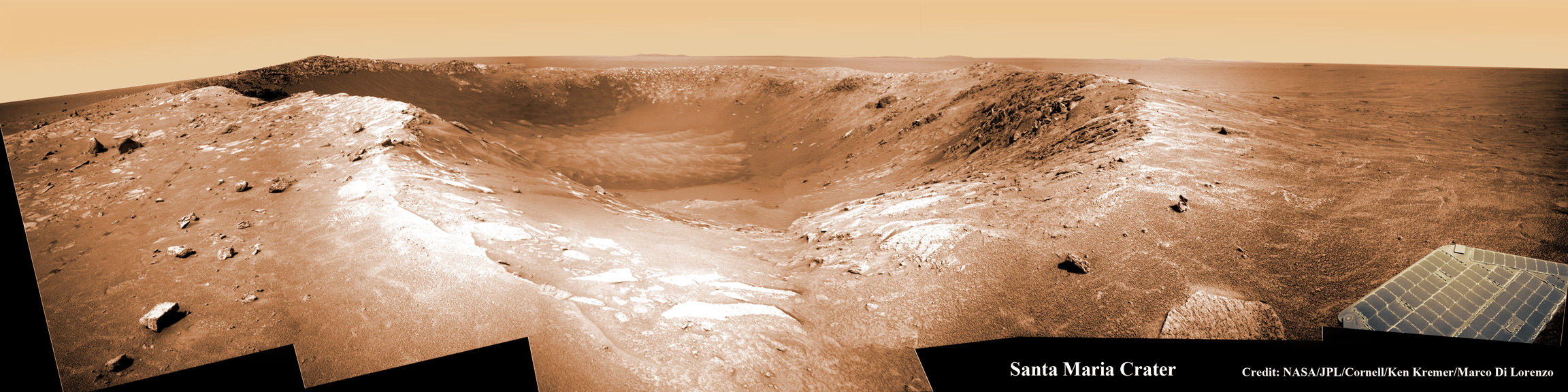
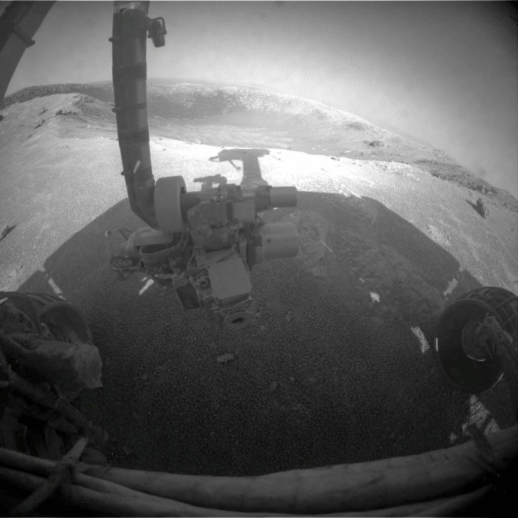
Opportunity drove within 2.5 meters of the rim and snapped this beautiful panoramic vista of the crater and distant horizon on Sol 2454. Note rover solar panel deck, antennae and sundial at left. Mosaic Credit: NASA/JPL/Cornell, Oliver de Goursac.
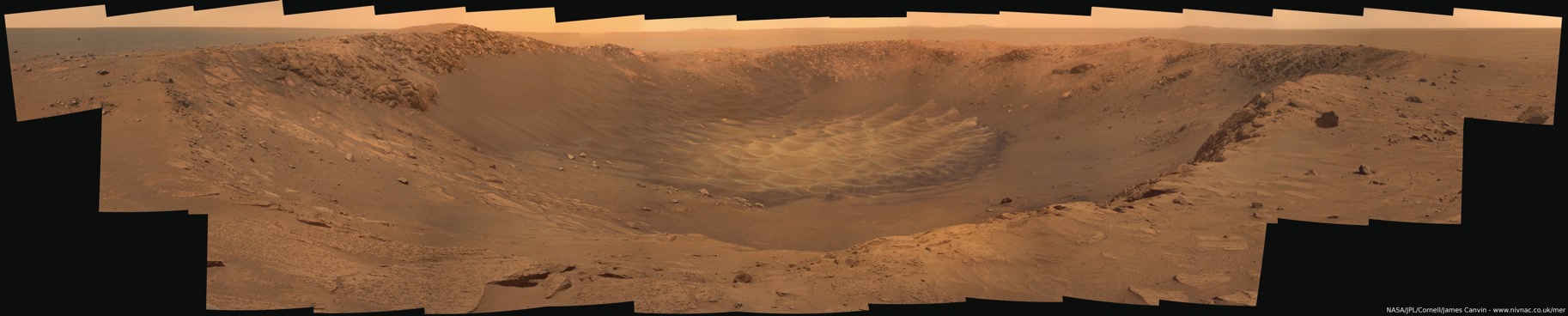
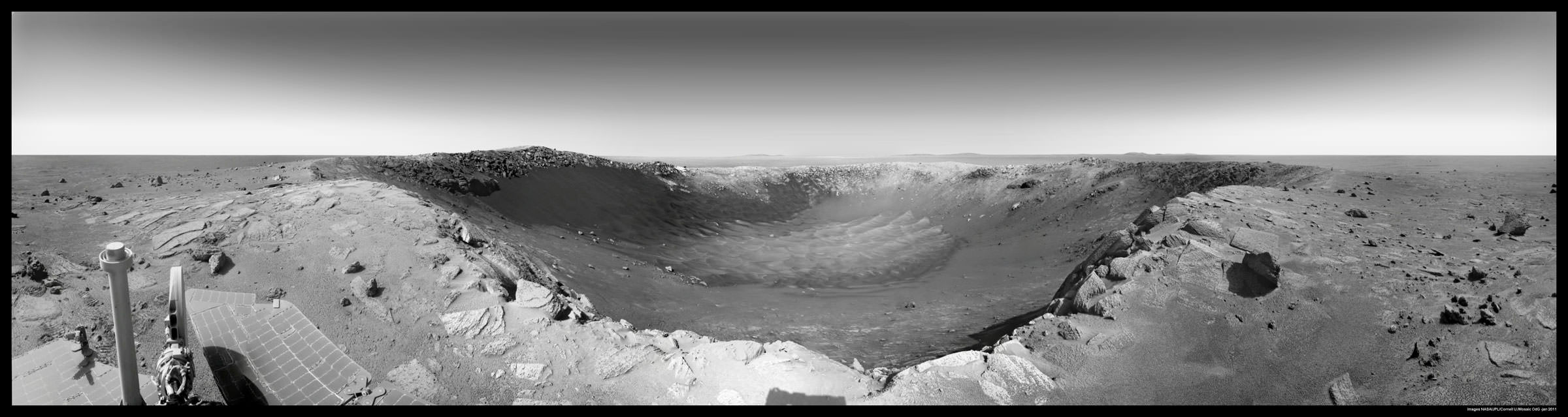
Opportunity drove to within 2.5 meters of the rim and snapped this gorgeous panoramic vista unveiling the whole interior on Sols 2453 & 2454. Note the steep walls and sand dunes on the floor. Mosaic Credit: NASA/JPL/Cornell, James Canvin

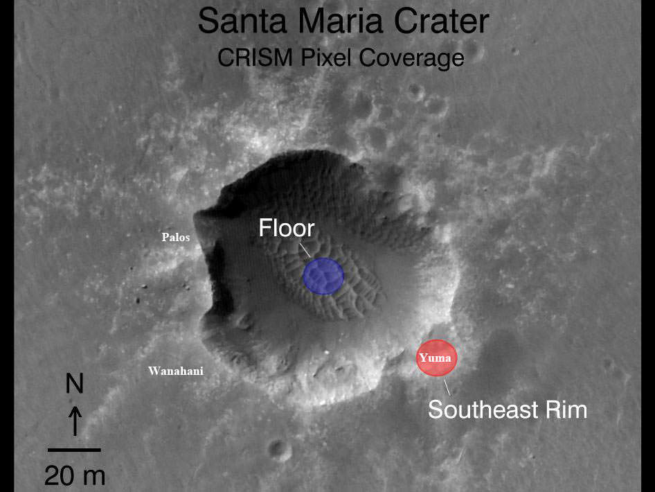
Opportunity took this panaromic mosaic from “Wanhani” just meters from the crater rim on Dec 29 (Sol 2464). Note rover tracks near rim at left, solar panel at right and numerous ejecta rocks. CRISM mapper results suggest water bearing materials are located at the southeastern section of the crater. Portions of distant Endeavour Crater are faintly visible as bumps on the horizon in the background. Mosaic Credit: NASA/JPL/Cornell, Ken Kremer, Marco Di Lorenzo
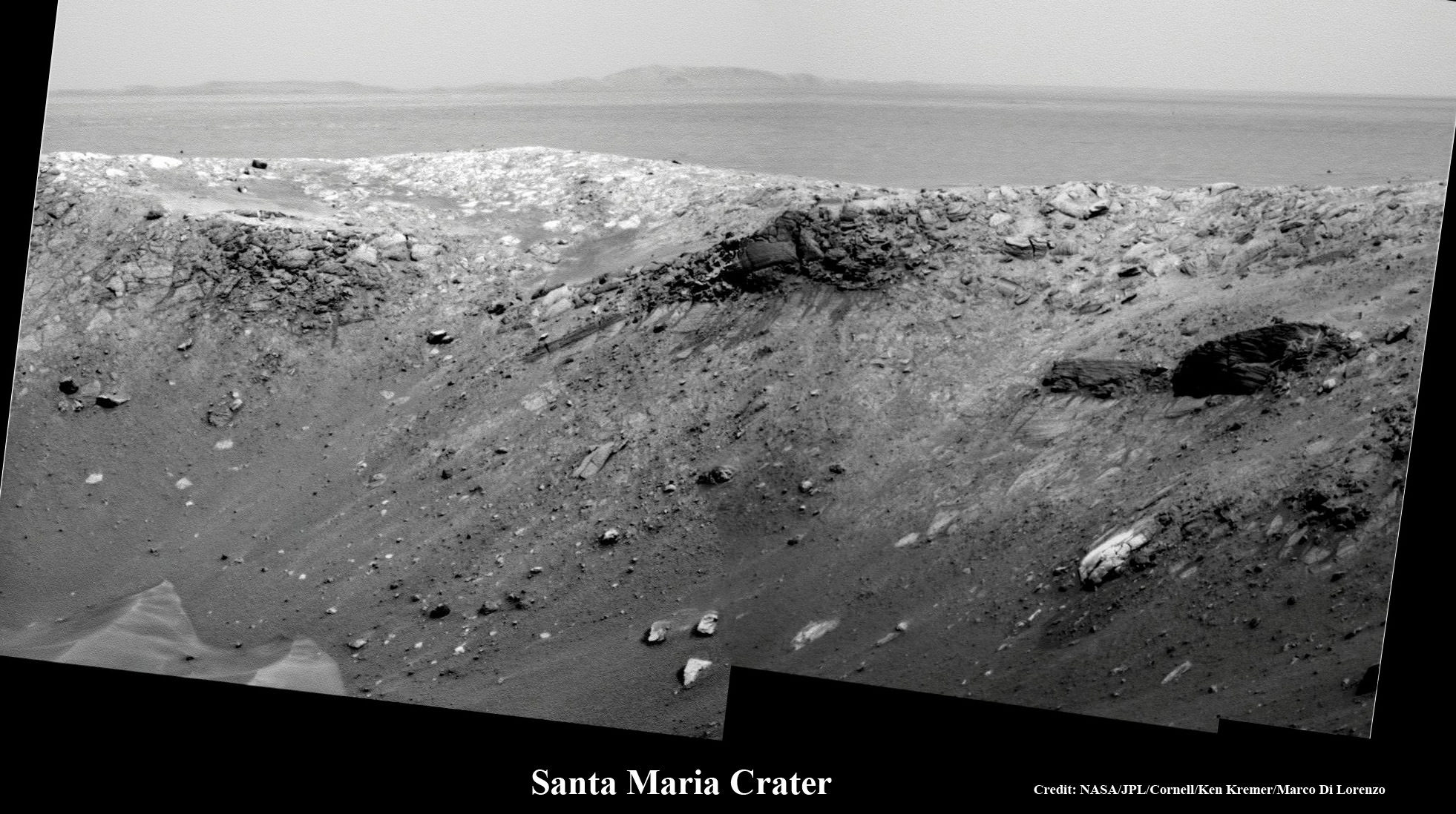
Santa Maria rim up close (80 meters away) and Endeavour rim (6 km away) on the horizon in the distance. Both craters show mineralogical evidence for the past flow of liquid water on Mars and are high priority science targets. Mosaic Credit: NASA/JPL/Cornell, Ken Kremer, Marco Di Lorenzo

Undulating sand dunes on the crater floor and southern portion of Santa Maria, inclined about five degrees. Mosaic Credit: nasatech.net
But there is no time to party and relax. The rover will soon resume driving to the next location – nicknamed “Yuma”. It will continue farther around the football field sized crater – measuring some 90 meters (295 ft) in diameter – to reach the exposures of sulfated hydrates located at the southeast portion of the crater near “Yuma”.
Opportunity must be in position at an important science target before mid January and the onset of solar conjunction and a temporary communications black out with Earth. The rover will remain stationary during conjunction.
At Wanahani, Opportunity is now hurriedly toiling away over the New Year’s period to collect a pair of long baseline, high resolution stereo image mosaics using it’s panoramic, multispectral imaging camera. See our initial Wanahani mosaics assembled here from the navigation camera images just received on Earth (Sol 2464).
The team is using all 13 filters on the filter wheels of the panoramic camera, according to Ray Arvidson, the deputy principal investigator for the rovers, in an interview from Washington University in St. Louis. Over the course of several days, the left and right “eyes” of the panoramic camera will gather data at various wavelengths to maximize the collection of spectral information about the hydrated minerals located in the craters interior.
Data downlink is limited by the available amount of flash memory aboard Opportunity and is the Achilles heel of rover operations. Virtually all the pictures and science is streaming back to Earth via NASA’s long lived Mars Odyssey orbiter. The team is working to get all the acquired science data offloaded as swiftly as possible,
Arvidson said that the team hopes that the meteor impact that excavated the crater also blasted some of these scientifically fascinating rocks free to spots which are more easily accessible – just outside the rim for close up analysis. Additional imaging and spectral data is also being collected from Mars orbit this new year’s weekend in hopes of quickly directing the rover to the best locations for science in the limited time available.
Opportunity will study the relatively fresh and uneroded ejecta rocks using all the instruments located at the end of the robotic arm. One target will be selected for a longer duration study during the period of solar conjunction, said Arvidson.
Opportunity will resume her long term trek to Endeavour crater after the end of solar conjunction in mid February. The western rim of Endeavour is about 6 km distant. Endeavour is a very compelling science target because it shows significant signatures for clay minerals which formed in the presence of neutral bodies of liquid water on Mars, billions of years ago.
Spirit and Opportunity celebrate 7 Years on Mars this month since the dynamic duo landed in January 2004. Look for my story soon.
I rather liked James Canvin’s image of Santa Maria Crater combined with human silhouette’s that help give a sense of the actual size the crater: http://www.unmannedspaceflight.com/index.php?act=attach&type=post&id=23446
Each individual is 2 meters tall from foot to top of waving hand. Distances are calculated from the orbital images.
Yes that beautiful image was included in my prior report here for exactly the reasons you’ve cited:
http://www.universetoday.com/81963/gorgeous-3-d-vistas-of-martian-crater-and-hydrates-at-santa-maria/
James Canvin’s new version is included in this story
If anyone is interested I have much higher resolution versions of my colour pan on my website. Clicking on the version Ken posted gets you the smallest version (1826×368) the full pancam resolution version is 14608 x 2944!
http://www.nivnac.co.uk/mer/index.php/b2453_draft
Thanks James !!!
Tho, my idea of Martian Lifeforms is dashed by the way the ‘sand dunes’ blend into the left side crater walls in a most natural way ! Blast ! there goes another ‘great idea’ ! lol
But what ‘forces’ cause these ‘dunes’ to shape ?
The ‘air’ is way too thin to impart ‘material shifting’ of the dunes, isn’t it ?
Oh yeah.. there’s wind on Mars… Opportunity’s tracks have recently been observed filling with dust at a rate far higher than expected. UT’s story – http://www.universetoday.com/81204/mars-rover-tracks-erased-from-existence/
Thanks for the links in the above comments ! It really shows the scale of the crater’s size well.
And for a funny thought: In this article’s 6th and 7th photos, the crater rim detail shot and the ‘inexplicable’ dunes on the crater’s floor; what if the ‘sand dune structure’ on the crater floor is the form that ‘Life’ takes on Mars !
Notice how in photo #6 the ‘sand dune’ is so abruptly different from the ‘crater’. It almost looks photoshopped in ! Like it’s not really part of the landscape, like it’s a ‘lifeform’ laying in wait at the bottom of the crater for something to come along so it can ‘grow’ ! haha, as its way of “directing a stream of negative entropy upon itself” -the definition of Life.
And the way, on the left side of the various photos, how it goes up the side walls of the crater, almost to the objection of the laws of natural physics ! for what we’d expect the next to impossibly thin Martian atmoshpere could ever produce, especially if this crater is only a few million years old, as speculated. How could the Martian atmosphere ever create such sand dune shapes up the side walls like this ???
There are several definitions of life, but that isn’t one of them. Modulo that “negative entropy” is a funky definition, modulo that one can describe a cell having a partial flow of entropy out by way of looking at entropy differences – that would make a refrigerator “life”.
The least constraining definition of life follows from defining its process, evolution. Evolution is a process that results in heritable changes in a population spread over many generations. Any population that is participate in such a process can be said to be life. (Though you may at any time want to cut away software, hardware and, for some, viruses, from the usual “wetware” by specific restrictions.)
First of all, well done to everyone involved and to the ‘bots themselves for keeping this mission going for as long as they have. Long may it continue.
I noticed in the bottom left of the picture a rock with an un-typical straight edge. It looks like a brick. How would a rock like that form given normal erosion on Mars? If I saw that on Earth I’d assume it was a man made house brick. Obviously, that can’t be the case here. Just curious – and no, I don’t think little green men left a brick next to a crater.