
[/caption]
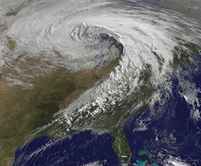
Yowza! – Here’s a satellite image of a storm of record-breaking proportions. On October 26, 2010, the strongest storm ever recorded in the Midwest spawned 24 tornadoes, 282 reports of damaging winds, violent thunderstorms, and torrential rains. The mega-storm reached peak intensity late yesterday afternoon over Minnesota, resulting in the lowest barometric pressure readings ever recorded in the continental United States (except for from hurricanes and nor’easters affecting the Atlantic seaboard.) The storm continues today (Oct. 27) with more tornado watches posted for Mississippi, Alabama, and Georgia, a blizzard warning for North Dakota, high wind warnings for most of the upper Midwest, and near-hurricane force winds on Lake Superior.
Read more about this super-storm on Weather Underground, but see below for what extremely low air pressure means.
Air pressure is one of the most important factors which determines what the weather is like. A mass of low pressure is an area of air that is rising. As it rises, it expands and cools. Cooler air cannot hold as much water as warmer air, so as the air rises the water will condense and form clouds. This is why an area of low pressure will often be accompanied by clouds and rain — which is what occurred on October 26 — lots of clouds and lots of rain and even snow.
But winds were even a bigger factor in this superstorm. Our atmosphere really doesn’t like big differences in air pressure, so where areas of low pressure meet up with areas of high pressure, winds blow in an attempt to combat the differences in the air pressure. The larger the difference in pressure the stronger the winds will blow. So, the extreme low pressure readings yesterday meant the winds were really howling — and they were. In my neighborhood in Illinois, we had a fairly study flagpole get bent from the winds. But that was nothing compared to the hurricane-like winds other places experienced: for example, Grand Marais, Minnesota — near the Great Lakes and near the area of the lowest air pressure readings — had sustained winds of 43 mph gusting to 59 mph, lasting for over 7 hours. Today, that region is still getting pummeled by winds and snow.
You can see the link to Weather Underground above to see what other weather extremes were experienced during this storm.
I can hear people in Mississippi, Alabama, North Dakota, and Georgia saying “I still don’t believe in climate change!” as their houses are covered in snow or destroyed by twisters…
@ Nancy:
Would you mind noting the value of the “lowest barometric pressure ever”? 😉
@DrFlimmer — Done. See the info that I’ve added to the article.
I live in Minneapolis, and we were right in the eye of that storm. It was intense. Amazingly the damage done to the area wasn’t worse than it turned out to be. There were only intermittently power outages and the occasional downed tree or power pole. I ended up walking outside not realizing how intense this was going to be and I literally nearly got blown off my feet. Fences, loose objects, you name it were flying around here and there. It was definitely hazardous. Driving was no fun either, especially with the slick roads. That was definitely an interesting experience, especially for late October here in Minnesota!
And well they could, since AFAIU the amplitude of extremes hasn’t been attributable to change or AGW specifically. IIRC the frequency of them likely are, see Stott et al paper in WIREs of this year (which I’m too lazy to check right now).
AGW would keep more thermal energy in the lower atmosphere (and set up a higher differential to the cooled upper atmosphere FWIW). Everything else equal and even with a “safety valve” of setting up more frequent but otherwise moderated “relaxations” (weather phenomena as side effects of climate drivers, more properly) one would expect more record-breakers, if not for anything else so for a better population of the distribution’s tails.
43mph gusting to 59mph? that’s a stiff breeze in western Scotland.
Thought occurred to me that if you are driving on a highway at 60 mph and get hit by 60 mph head wind, the car just experienced 120 mph air resistance! No wander car feels unstable at high speed in a heavy windy day.
“I can hear people in Mississippi, Alabama, North Dakota, and Georgia saying “I still don’t believe in climate change!”
Seriously? Don’t you mean that we don’t believe in man made global warming? Climates always change. Pop Quiz… How many volcanoes are active on the planet? How many produce more hazardous materials than man has, or ever will? Sure, we have made an impact but Mother Earth destroys, consumes and time passes on like it will long after we are gone.
I woke up to 7 inches of snow in Northern MS just this past winter none was forecast. Record snowfall in Northeast US. Early August 2009 it was too COLD to swim in Mississippi…
Climates change. We are adapting nicely…Time to cope with it 🙂
You guys are a bunch of softies. :p
We get hurricanes from time to tom, along with occasional severe thunderstorms with high winds and even tornadoes. Honestly, I’m a little disappointed we didn’t get hit by a tropical storm this year. Ya’ll need to toughen up. 😉