
[/caption]
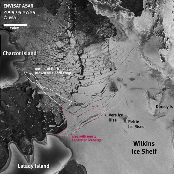
The latest satellite images show that icebergs have begun to break away from the northern front of the Wilkins Ice Shelf – indicating that the huge shelf has become unstable. This follows the collapse three weeks ago of the ice bridge that had previously linked the Antarctic mainland to Charcot Island. On April 24, satellite data from ESA’s Envisat satellite and the German Aerospace Centre’s TerraSAR-X satellite showed that the first icebergs had started to break away from the fragile ice shelf. A very rough estimate suggests that, so far, about 700 sq km of ice has been lost from the Wilkins Ice Shelf.
Three weeks ago, the ice bridge shattered very quickly, but it is expected that the current discharge of ice will continue for some weeks. The process where portions of a glacier’s leading edge break off as icebergs into an adjacent body of water is known as “calving” and this is occurring as a result of fracture zones that have formed over the last 15 years and which turned Wilkins into a fragile and vulnerable ice shelf.

“The retreat of Wilkins Ice Shelf is the latest and the largest of its kind. Eight separate ice shelves along the Antarctic Peninsula have shown signs of retreat over the last few decades. There is little doubt that these changes are the result of atmospheric warming on the Antarctic Peninsula, which has been the most rapid in the Southern Hemisphere,” explained David Vaughan from the British Antarctic Survey.

“The changes to Wilkins Ice Shelf provide a fabulous natural laboratory that will allow us to understand how ice shelves respond to climate change and what the future will hold for the rest of Antarctica,” Vaughan commented. “The quality and frequency of images acquired by ESA satellites mean that the break-up of Wilkins Ice Shelf can be analyzed far more effectively than any previous event. For the first time, I think, we can really begin to see the processes that have brought about the demise of the ice shelf.”
However, it is still unclear how the situation will evolve, Humbert said. “We are not sure if a new stable ice front will now form between Latady Island, Petrie Ice Rises and Dorsey Island. If the connection to Latady Island is lost, the projected loss of 3370 sq km of ice might be greater – though we have no indication that this will happen in the near future.”
Source: ESA
Off topic: Anyone else noticed the striking similarities to the contours of western Europe?
Just for fun I superimposed the satellite photo onto a map of Europe and ….. amazing! Charcot Island resembles Ireland. Although the tunnel (ice bridge) is/was there England and Schotland seem to be missing. Holland is about right, but the top islands seem to have moved upwards. Denmark is in place and so is the western part of France.
The Wilkins ice shelf breaks up and reforms with some regularity due to it’s location on the western side of the peninsula, which is only a small portion of the total landmass of the continent. Antarctic ice is actually growing overall. The majority of the ice loss has been around the peninsula, which reaches out into open water towards the equator, creating a relatively narrow channel between the tip of South America. That stretch of ocean is well known for powerful storms and strong ocean currents. So the ice shelves calve off sometimes as a result. That’s why it’s called calving, because it’s ice breaking up due to the motion of the water underneath, not melting from warmer temps. This is just another misleading exaggeration stoking the Anthropogenic Climate Change fearmongering flames.
http://www.theaustralian.news.com.au/story/0,25197,25349683-11949,00.html
Instead of “The majority of the ice loss…” should be “The majority of any ice that has been lost…”
🙂
@ Lawrence B. Crowell:
Sorry, your statement is false.
MYTH
THE POLAR CAPS ARE MELTING
Wrong. The British Antarctic Survey, working with NASA, last week confirmed ice around Antarctica has grown 100,000 sq km each decade for the past 30 years.
Long-term monitoring by the US National Oceanic and Atmospheric Administration reports the same: southern hemisphere ice has been expanding for decades.
As for the Arctic, wrong again.
The Arctic ice cap shrank badly two summers ago after years of steady decline, but has since largely recovered. Satellite data from NASA’s Marshall Space Flight Centre this week shows the Arctic hasn’t had this much April ice for at least seven years.
Norway’s Nansen Environmental and Remote Sensing Centre says the ice is now within the standard deviation range for 1979 to 2007.
See, here, for details and links to back up above.
Pseudoscience knows no bounds. Wong, the breakup of Antarctic and Greenland icesheets has accelerated incredibly this last decade. It seems that error in thinking about cosmology extends to Earth science as well.
Lawrence B. Crowell
From the article that solrey refers us to:
“A paper to be published soon by the British Antarctic Survey in the journal Geophysical Research Letters is expected to confirm that over the past 30 years, the area of sea ice around the continent has expanded.”
And: “Australian Antarctic Division glaciology program head Ian Allison said sea ice losses in west Antarctica over the past 30 years had been more than offset by increases in the Ross Sea region, just one sector of east Antarctica.”
It is unfortunate that these facts were not included in the above post, but that is how “real science” is done here. Omit the inconvenient science.
Not “real science”, but a story of a shattered dream:
In the later years of the last century, there were midsummer cruises on a Russian icebreaker to the North Pole available. It was a luxury trip, very expensive. One of the highlights: everybody stand on the ice around the Pole for a group photo. I always wanted to do the trip, but it was just too expensive.
After years of dreaming of taking the trip, an unexpected well-paid job put me in the position to apply for a ticket…. alas, the cruises were discontinued. The ice had become too thin for many people safely standing on it together.
A similar cruise is available again these days. The attraction: swimming in a hole in the ice on the North Pole…..
🙁
I second this. I am by no means a climate scientist, but I do track reports from the real science, and the conclusions are pretty clear. Greenland ice is breaking up as more water melt flows through cracks which permit the ice to slide out to sea. These Antarctic shelf break ups are occurring several times a year, far more than in the past.
Lawrence B. Crowell