
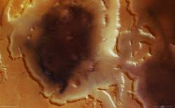
This amazing image was captured by ESA’s Mars Express spacecraft, and shows the Deuteronilus Mensae on Mars, a region shaped by glaciers millions of years ago.
The large depression in the middle of the image is approximately 2 km (1.2 miles) deep, and measures 110 km (68 miles) across. Many deep valleys cut by intense flooding feed into the region. It’s believed that these valleys were caused by intense flooding from melted water ice. This water froze quickly, turning into glaciers that flowed downhill.
Although it’s cold and dead now, Mars was once geologically active. It’s believed that rising magma, or impact events could melt vast regions of ice, resulting in major flooding events.
Original Source: ESA News Release