
On the morning of February 24th, after years of proxy conflict in the border region, Russia invaded the neighboring country of Ukraine. This invasion was the culmination of eight years of conflict that began with the removal of Ukrainian President Viktor Yanukovych (a long-time ally of Russian President Vladimir Putin) and Russia’s subsequent annexation of Crimea. This invasion has prompted the global community to mobilize and find ways to support Ukraine!
For instance, you have Earth Observatory System Data Analytics (EOSDA), a California-based “all-in-one cloud workspace” for Earth observation solutions. In a recent statement, EOSDA CEO Max Polyakov appealed to satellite imagery firms and space agencies worldwide to share their recent and real-time high-to-medium resolution optical and radar satellite imagery with EOSDA to assist military and humanitarian aid efforts in the region.
Today (March 2nd) marks the seventh day since the Russian invasion began. It commenced with shelling in many different locations, followed by Russian forces moving in from the north, east, and south. Columns of Russian troops and tanks then began moving towards the capital city of Kyiv, and the major cities of Kharkiv and Dnipro (just beyond the Russian-controlled regions in the east and the Crimea), followed by rocket strikes against civilian and military targets.

This invasion has resulted in the deaths of hundreds of Ukrainian civilians and military personnel. It is estimated that this invasion will cause 50,000 casualties and force millions to become refugees. The situation has led nations worldwide to commit military aid to Ukraine (in the form of weapons, equipment, and loans) and medical/humanitarian assistance for displaced civilians and those that are tragically caught in the crossfire.
According to Max Polyakov (founder of EOSDA), what is needed right now is up-to-date satellite data that can assist in anticipating Russian advances and evacuating civilians. As he said in an EOS press release:
“The economic, political, and humanitarian consequences of the war in Ukraine already are too high to stand on the sidelines. If you can help us, please provide the SAR data that actually makes a difference. Outdated optical satellite imagery is applicable for PR purposes and as evidence of war crimes for future international criminal court proceedings. Ukraine needs actionable intelligence to be able to save the millions of innocent people and the sovereignty of the country”.
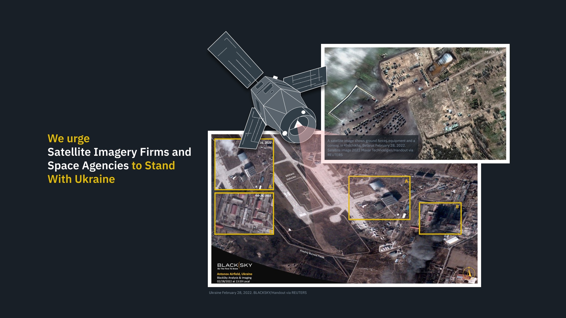
The EOSDA team has updated its platform to analyze satellite and radar imagery to provide an up-to-date assessment of the situation on the ground. This includes current or live Synthetic Aperture Radar (SAR) data that will provide situational awareness and relevant intelligence regarding the movement of Russian troops and activities (especially refueling). This information is especially important since SAR data can track activity at night and regardless of cloud cover (unlike optical data).

The EOSDA has specifically requested cooperation from its peers in the aerospace community located across Europe, North America, and Asia. Specifically, they are calling on Capella Space, Iceye, QPS & Synspective, Spacety, Airbus, COSMO SkyMed, Sar-Lupe, Umbra to provide SAR data. Meanwhile, they are asking Planet, MAXAR, Airbus, SIIS, Spaceview, Blacksky, and other companies to provide optical data.
EOSDA states that the data will be processed, analyzed, and shared in real-time with Ukraine’s Armed Forces and humanitarian organizations. They also state that data providers that face restrictions (as a result of engaging with private companies in Ukraine) will be put in touch with the Minister of Digital Transformation of Ukraine (Mykhailo Fedorov) and other government and security officials for direct data delivery and/or sanctioning of further processing by EOSDA.
Companies with data are urged to write to contact [email protected].
Further Reading: Earth Observation System (EOS)
I hope Ukraine gets what they need, but it seems odd that EU isn’t already supplying that:
“BRUSSELS, Feb 28 (Reuters) – The European Union has asked its satellite centre in Madrid to provide intelligence to Ukraine about Russian troop movements and EU countries are determined to further increase their bilateral military support to Kiyv, the EU’s head diplomat said.”