
The Perseverance rover now has a new tool to help scientists and engineers figure out where the rover goes next. The new tool is the little rotorcraft that was tucked away in the rover’s belly, the Ingenuity helicopter. Ingenuity has now started doing aerial surveys to scout ahead for Perseverance.
During its most recent flight, Ingenuity captured 10 color images ahead of the region where Perseverance is traversing, to help the team figure out whether the rover should remain in its current location and do more scientific investigations or drive to investigate potentially interesting rocks in the nearby “South Seítah” area.
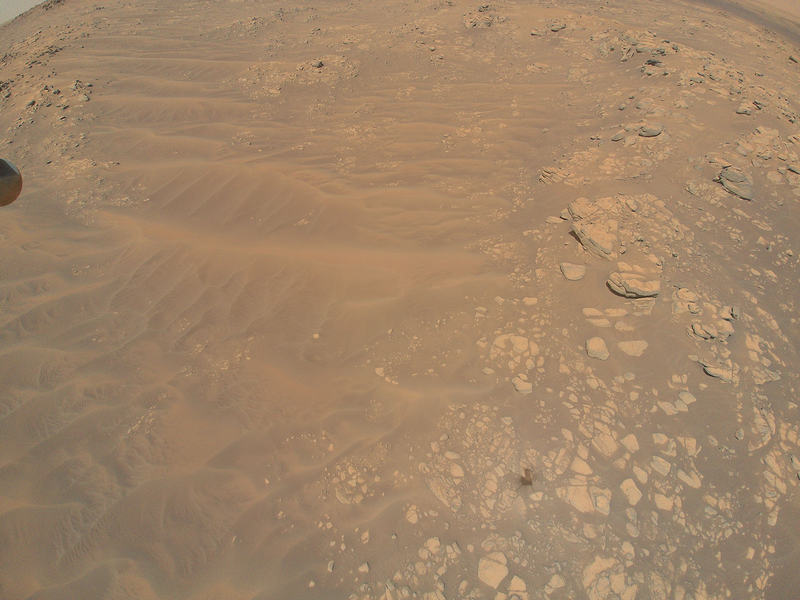
“From a science perspective, these images of South Seítah are the most valuable Ingenuity has taken to date,” said Ken Farley, project scientist for NASA’s Perseverance rover. “And part of their value may be in what they are not showing. Sedimentary layers in rocks are not readily apparent in the image, and there may be areas that could be difficult to negotiate with the rover. There is work to do by our science and rover driving teams to understand better how to respond to the new data.”

Ingenuity took the images from an altitude of 33 feet (10 meters). The team said the flight – the helicopter’s 12th so far — was one of the most complicated the helicopter team has executed. It was also the longest-duration flight to date (169.5 seconds) with multiple waypoints as it flew from relatively non-descript terrain outside South Seítah into much more varied terrain inside, and then back out again.
Perseverance itself has taken over 125,000 images in the six months since it landed on Mars. The images are incredible, and not only are they stunning pictures from another world, they also allow scientists to make observations of the rocks and Martian regolith. And the images are also important from an engineering perspective, in that they help the “rover drivers” determine the best path forward, based on what they see in the images.
Additionally, the Perseverance team has the power of the Mars Reconnaissance Orbiter at its disposal. MRO carries the most powerful camera ever sent to the Red Planet, and its images can reveal details as small as 1 meter (3 feet) across and create precise 3D maps of the surface. Combined with a complementary camera that provides a wider context of the surface, MRO examines the surface at great detail to identify geologic processes that might be interesting for the rover to examine more closely.

Prior to Ingenuity’s latest flight, the majority of what the Perseverance science team knew of the southern portion of the Seítah feature came from MRO. The team said that based on that data, they believed the site could possibly be a treasure trove of complex geology, providing information that could play a valuable role as the rover team searches for signs of ancient microbial life and attempts to characterize the geology of the area and to understand the area’s history.
But Ingenuity has now provided additional data that shows signs of layered, sedimentary rock that could have been deposited in water, intriguing rocky outcrops accessible to the rover, and safe routes the rover could take into and back out of the area.
“What this image may be saying is, we don’t need to drive further west to obtain the best geologic variety of this first science campaign,” said Farley. “If we decide to make the trip to South Seítah, we’ve got some valuable intel on what we’ll encounter. And if the decision is to stick around ‘Artuby Ridge,’ the rover’s current location, we’ll have saved valuable time. It’s a win-win.”
We’ll provide more updates on Ingenuity’s next flights, and where Perseverance goes next.
Lead image caption: Flight 12 View of South Seítah: This image of the “South Séítah” region of Jezero Crater was captured by NASA’s Ingenuity Mars Helicopter during its 12th flight at Mars, on Aug. 16, 2021, and has proven useful to the Perseverance rover science team as it plans its science investigations. Credits: NASA/JPL-Caltech.
Source: JPL