
Erosion can take many forms. Most commonly known is water wearing away the sides of creeks or lakes. But wind can erode just as effectively, especially if it carries dust particles that can eat away at otherwise solid objects. While this wind-driven process is most commonly observed on Earth, it plays a role in the history of most other rocky bodies that have an atmosphere. Recently, a team lead scientists from the Planetary Science Institute found evidence for some erosion from between 50,000 and a few million years ago in Mars’s polar ice cap. That is a blink of the eye by geological standards.
No matter how old they are, the patterns the eroding winds create are breathtaking, spiraling into what looks like a fractal pattern when viewed through the eyes of some digital mapping software. The area affected by the winds is also absolutely enormous, coming in at 10 times the total volume of the Grand Canyon.
Credit: USGS / ERA
The spiral patterns are actually troughs in the ice that form as a byproduct of the erosion processes. Those erosion processes actually carve chunks out of the polar ice cap, exposing long buried ice that is otherwise inaccessible. Models of the ice cap hint that that newly accessible ice might hold some interesting further discoveries if human or robotic explorers are able to access them.
One potential discovery is to see if the water stored in the polar ice cap is fresh water or not. Much of the easily available water on Mars has dissolved hazardous chemicals, such as perchlorates, that make it unsuitable for human use. Purifying this water to make it useable would be both energy and time intensive, neither of which will be in abundance in any early Martian colony.
Alternatively, models suggest that the ice exposed as part of the polar cap erosion process was never held in liquid form, and therefore might be free of the impurities that plague other water sources on the red planet. If that is the case, the polar cap itself might serve as a reservoir for humanity’s water needs when human explorers finally set foot on Mars.
Another discovery is more scientific than practical, but interesting nonetheless. Models also suggest that the new exposed ice is ancient, dating back hundreds of millions of years. On Earth, scientists regularly drill ice cores to collect data on the paleoclimate – the climate of the planet that happened before humans started keeping records. Unfortunately, these techniques are useful only back a few million years due to Earth’s ever changing climate.
Credit: MOLA Science Team, MSS, JPL, NASA, over a CTS mosaic credit: NASA / JPL
Alternatively, the ice cores exposed through erosion on Mars might date back hundreds of millions of years, as they have not melted and reformed repeatedly over that time, as the cores on Earth have. This would be the equivalent of looking back to the climate during the time of the dinosaurs on Earth. It would provide an insight into the climate of the red planet farther back than almost any tool available currently on Earth.
That additional information is only accessible if we are able to get to the exposed ice though. For now, there are no missions planned specifically to search out these pockets of exposed ice. But if the erosion process continues, there might be some even newer pockets of it to explore when humans finally do visit.
Learn More:
PSI – Huge Spiral Troughs on Mars are Young, Formed by Erosion
Nature Scientific Reports – North polar trough formation due to in-situ erosion as a source of young ice in mid-latitudinal mantles on Mars
UT – How old is the ice on Mars’ north pole?
UT – Here’s the Best Place for Explorers to Harvest Martian Ice
Lead Image:
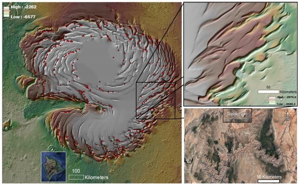
The image on the left is a image of Mars’ nothern polar ice cap with digital enhancement, specifically highlighting the eroded trough spirals. The red dots denote mounds and depressions. There is an inset of Hawai’i’s big island for scale. The upper right image is a zoom in that is equivalent in size to the Grand Canyon (see in bottom right).
credit: MOLA Science Team, MSS, JPL, NASA.