
NASA’s Artemis Program is planning to land astronauts on the Moon’s south pole. To prepare for this, NASA’s Solar System Exploration Research Virtual Institute (SSERVI) is creating the Lunar South Pole Atlas (LSPA). As part of that Atlas, NASA is mapping the topography of the region, including the mountains.
When we think of the Moon’s geography, we usually think about craters, which are everywhere, and bear the names of prominent humans. We also think of the vast areas of lava flows, which we call seas, or maria. But the Moon also has mountains, and some of them are surprisingly tall.
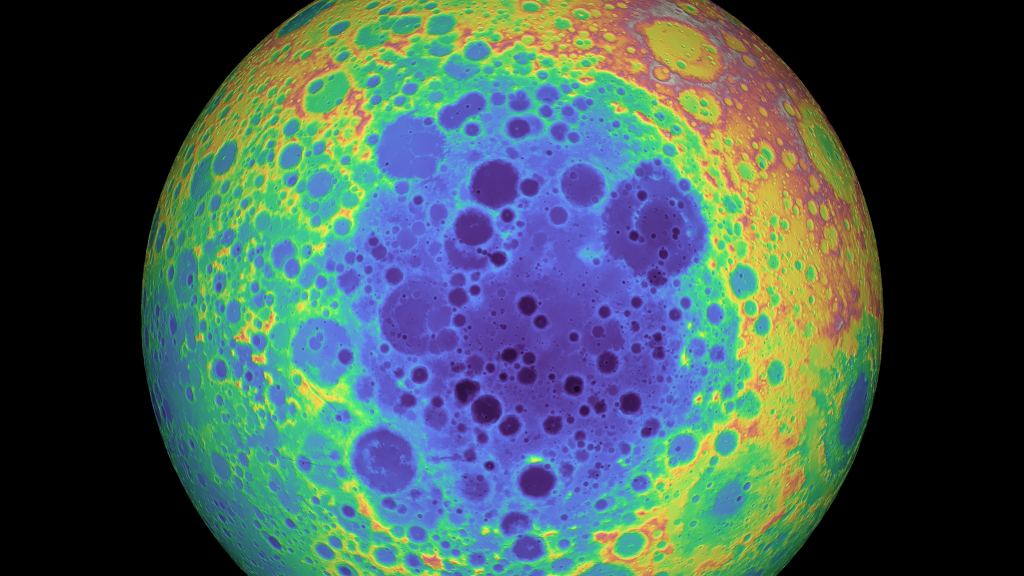
Lunar mountains are called massifs, and the south pole is home to several of them. Scientists think that they may be related to the massive impact basin on the Moon’s south pole, called the south pole-Aitken basin. It’s the largest, and also the oldest, impact basin on the Moon, and one of the largest in the Solar System. That impact may have created the mountains.
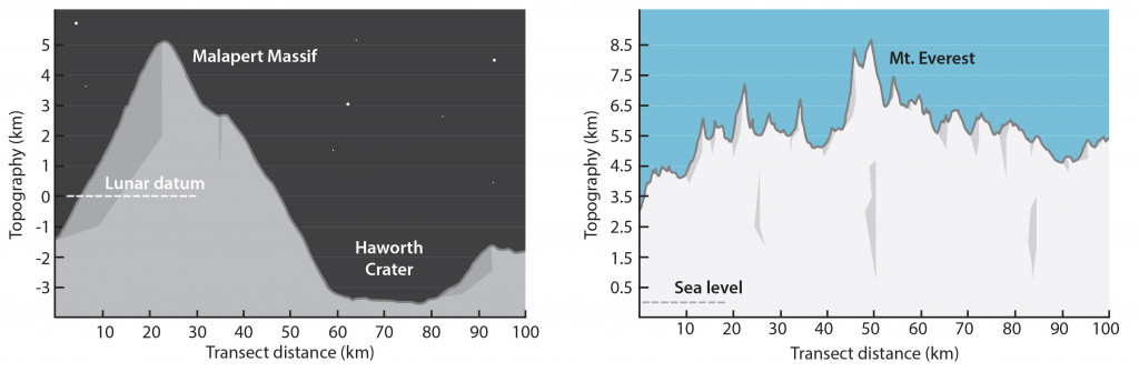
Scientists with the Lunar South Pole Atlas have created two new images of those mountains that show their elevation compared to Earth’s tallest mountain, Mt. Everest. The two images are of Malapert Massif and Leibniz Beta.
Malapert Massif is adjacent to the Haworth crater, and the change in elevation between the two is greater than 8 km (5 mi). That’s very close to the height of Mt. Everest above sea level.
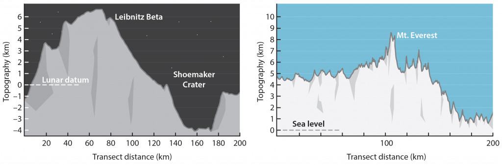
The second new image in the LSPA is of Leibniz Beta. It has the highest-elevation summit of anything in the region. It’s next to Shoemaker crater, and the elevation change from the crater to the peak is 10 km (6.2 mi), higher than our own Mt. Everest.
NASA is aiming for an extended human presence on the Moon, centered on the south pole region where there are water ice resources. The Lunar South Pole Atlas is a collection of maps, images, illustrations, and data products designed to support NASA’s mission.
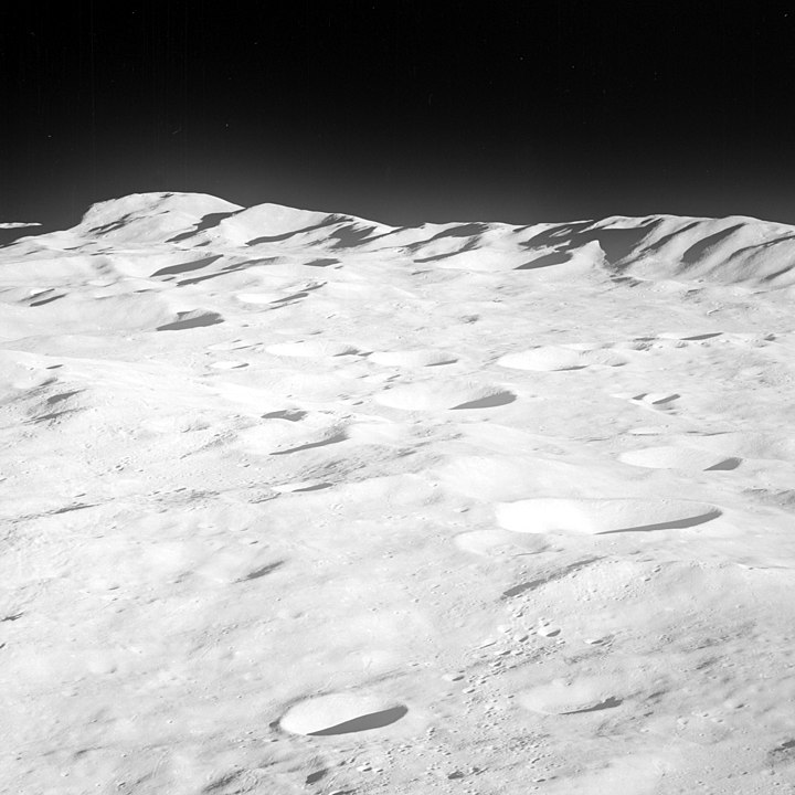
The astronauts on Apollo 8 also supplied us with images of the south pole mountains. Apollo 8 was the first mission to orbit the Moon, though it didn’t land. It’s also the first crewed mission to leave Low-Earth Orbit. While orbiting the Moon, they took this picture of the mountains rimming the south pole Aitken basin.
There were proposed missions to Malapert massif, and one of them was proposed by David Kring, who is also the Principal Investigator for the Lunar and Planetary Institute. That mission was part of the Constellation program, a cancelled crewed mission to the Moon proposed in the mid-2000s.
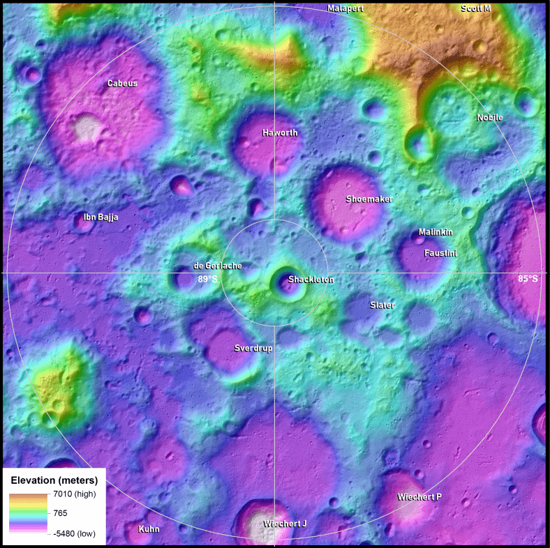
The Lunar South Pole Atlas is an interesting collection of data products. It contains topographic maps, permanent shadow maps, slope maps, and other images and illustrations of different features of the Moon’s south pole. When Artemis astronauts land there, they’ll be making use of the Atlas. Their mission will also no doubt produce a lot of new content for the Atlas.
More:
- Press Release: Scale of Lunar South Polar Mountains
- NASA: Lunar South Pole Atlas
- Universe Today: NASA is Planning to Build a Lunar Rover With a 1-Meter Drill to Search for Water Ice