

Magnificent images of avalanches of ice and rock in the northern polar regions of Mars have been captured by NASA Mars Reconnaissance Orbiter’s (MRO) High Resolution Imaging Science Experiment (HiRISE). These images are not of landslides that have happened in the past, they are actual Mars avalanches happening at the moment of observation. This rare event will be of tremendous value to Mars scientists currently analysing the effects of seasons on the landscape and will provide information on the geological activity of the planet…
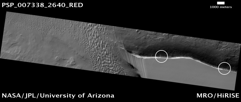
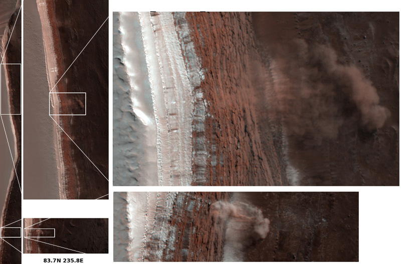
This event occurred along a scarp (a distinct cliff, with a steep runoff) around the North Polar Region where surface ice can be found in large quantities. The HiRISE instrument was being used to assess seasonal changes around the North Pole when four areas of activity were seen along the scarp. HiRISE was witness to something more familiar on Earth than on Mars: avalanches.
This particular scarp is a high cliff over 700 m (2300 ft) tall and slopes at over 60 degrees. A mixture of ice, rock and dust can be seen, frozen in time, as it is plummeting down the slope, ejecting a plume of dust as the debris begins to settle on the gentle slope at the bottom of the cliff. The ejected cloud is approximately 180 meters across and extends about 190 meters beyond the base of the cliff. It is worth noting that the clouds are large 3D structures reaching into the Martian atmosphere and not 2D patterns on the surface (shadows from the plume can be seen to the lower left of the clouds of dust).
The Martian landscape does not change very much over millions of years. Unlike the Earth, Mars does not have a thick, eroding atmosphere blasting away at the surface features. The lack of water also reduces these erosion effects. Mars also has very little geological activity as core reactions are thought to have slowed or even stopped – there is therefore very little tectonic movement, no major earthquakes and no evidence for present volcanic activity.
So what caused these avalanches? HiRISE scientists have some ideas:
- Disappearance of carbon dioxide frost, dislodging rocks.
- Expansion and contraction of ice due to seasonal temperature differences.
- Small Mars-quakes.
- A nearby meteorite impact.
- Vibrations from other avalanches causing other avalanches along the scarp
It seems most likely that the trigger may be down to seasonal changes. As the North Polar Region heats up (progressing toward summer), solid carbon dioxide (“dry ice”) may be subliming, weakening rocks around the edge of the cliff. The same could be said for the thermal expansion and contraction of water ice as the seasonal air temperature becomes warmer or cooler.
Whatever the cause, we are very lucky to have captured this event, the science collected from these observations will be critical to understanding how the Martian landscape can change very rapidly. The HiRISE instrument continues to return the most magnificently detailed images of the Red Planets surface, these observations of Mars avalanches will certainly go into the Mars Reconnaissance Orbiter’s Hall of Fame…
Source: HiRISE Project Site
Spectacular! This will definitely be one of THE enduring ‘legacy’ images not only for the MRO and HIRISE, but for solar system exploration in general. Congrats to the MRO team!
Yeah, I agree. We’ll be seeing an awful lot more of this image in the years to come (until we get there ourselves and video something similar).
I only came across the HiRISE website yesterday and was absolutely blown aways with some of the recent images that have come back!
Being able to compare activity on our planet to another to such detail will enable us to learn so much more about not only Mars but our own planet too
If some thing falls and nobody saw it, did it make a noise?
Guess this is the first to make a noise.
Stunning pictures !
I bet these will turn out to be fairly common. With the change of seasons on Mars a large amount of carbon dioxice ice in the polar caps sublimates into gas in the spring and then condenses back into ice in the winter. It makes this layered region. I’m guessing that in the spring the ice can evaporate quickly enough to kind of blow the dirt apart. And enough volume could be lost to make the ground highly unstable, making it unsafe for human or even robot explorers.
Another interseting phenomon I have heard about happening on Mars, and also on IO in one case, is where there is a lot of weight on top of ice so there is pressure on it, the ice does not sublimate, but if the pressure is released, just as with a soda pop, when you release the pressure the amount of CO2 ice in the soil is more than can be disolved at the temperature at the new pressure, and so it violently converts from the ice to a much bigger volume of gas. This blows the ground apart, so to speak. So, I think we will see more of these on Mars. On IO what I heard was happening was this volcano was spewing huge plumes of sulpher dioxide, which landed back on the moon as snow. This precipitation piled up and other material could land on it, resulting in layers and in this case a lot of sulpher dioxide got burried under some other material and was mixed with that material. The underside of the pile started getting warmer due to the moon’s internal heat and this caused the warm CO2 ice mixed in with the “dirt” to act again like soda pop and when the pressure was relieved by some nearby activity, eploded into a foam and disapated as a gully.
Wow !
This is so exciting, kudos to the HIRISE team. Quick question: can spectrographic analysis be made from this image of the plume?
If they got it as a moving image, that would have been seriously cool. That said, the stills are spectacular stuff.
This is amazing, truely. The idea that, not once or twice, but four times we’ve captured incidental images of martian avelanches is awesome!
It probably does happen fairly frequently, IMO, like Jason said. Explosively.
Amazing is all I can say. Yes, bravo, cudos, etc.
I think we must add one more potential cause to the Martian avalanches – tidal forces created by the MRO itself. Shame on us for damaging another planet!
And yes, I am just kidding! Just thought I’d beat the nay-sayers to the draw. :o)
Awesome pictures! Kudos to NASA!
Just a thought.
We are considering colonizing Mars, but what about the lack of an electromagnetic field to protect us from the blasts of radiation from our star?
These blasts are mega dangerous to our forms of life.
Any Ideas?
Just another thought, what does all this matter about our way of living on the Earth.
Mars needs oxygen, water,plants,this is mission impossible. What a joke.
Some of these avalanches are actually a ‘glacier’ movement type process. Along this scarp are many such landslide locales, some of which are repetitious and long lived ongoing active geologic transport of material to the plains below. At the plains level some landslides lead to channels which either transported ice or liquid water toward the Northern lowlands. I’ll return with a link for images- http://www.marsroverblog.com/forum –
try ‘Mars landslides’, early 2008.