

Just in time for the holidays, NASA’s Curiosity rover is celebrating Christmas 2015 at a Red Planet Paradise – spectacular “Namib Dune.” And she marked the occasion by snapping her first ever color self-portrait with the mast mounted high resolution Mastcam 34 mm camera.
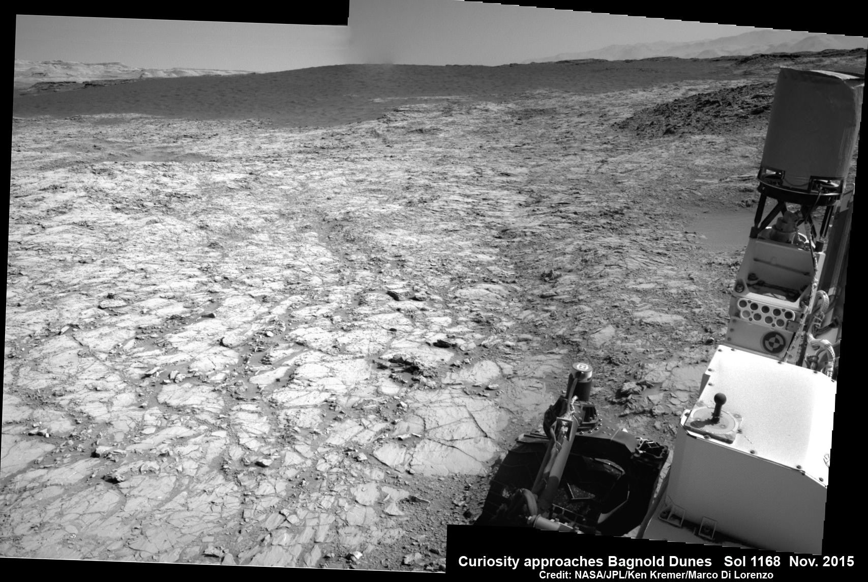
Heretofore Curiosity has taken color self portraits with the MAHLI camera mounted at the end of the 7-foot-long (2-meter-long) robotic arm, and black and white self portraits with the mast mounted navcam camera.
The new Mastcam color self portrait was taken just days ago on December 19, and includes the first ever color images of the rover deck. Previously, Curiosity has used the Mastcam color camera to take tens of thousands of exquisite high resolution panoramic images of the magnificent looking Martian terrain, but not the entire rover deck which includes the inlet ports for the pair of chemistry labs in the robots belly.
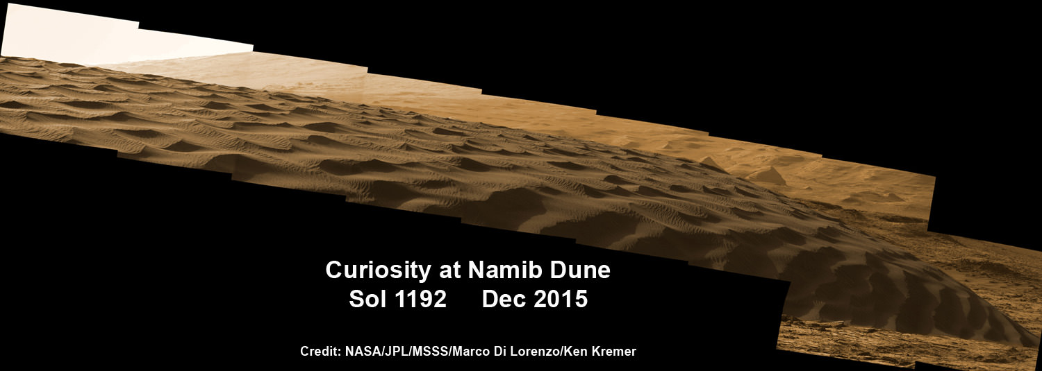
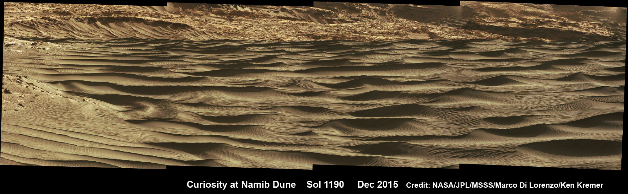
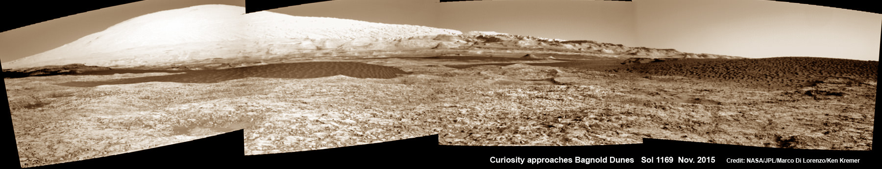
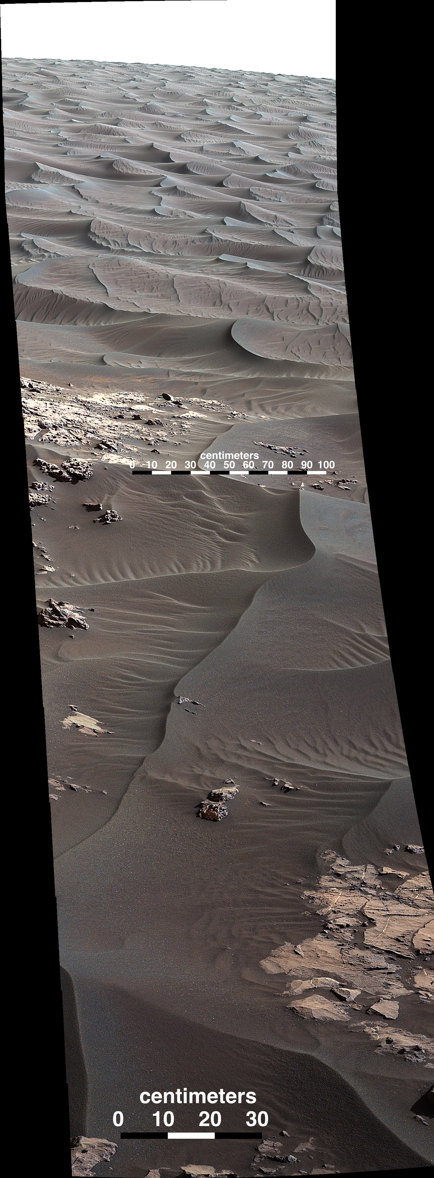
Curiosity arrived at the outskirts of Namib Dune in mid-December. And as the images show Namib Dune is humongous and unlike anything encountered before by Curiosity. See our exclusive photo mosaics above and below from the image processing team of Ken Kremer and Marco Di Lorenzo.
Why snap a Mastcam self portrait now? Because there’s unique science to be gained from the Red Planets swirling winds whipping up dust and sand particles with the rover now at the edge of the giant dune field at the foothills of Mount Sharp, and to check for buildup of particles on the rover deck.
“The plan includes a Mastcam image of the rover deck to monitor the movement of particles,” wrote MSL science team member Lauren Edgar, Research Geologist at the USGS Astrogeology Science Center, in a mission update.
Namib Dune is part of a massive field of spectacular rippled dark sand dunes, known as the “Bagnold Dunes” – located at the base of Mount Sharp and range up to two stories tall.
The six wheeled rover was dispatched to the dunes to conduct humanity’s first up-close investigation of currently active sand dunes anywhere beyond Earth.
“Namib is an Aeolian paradise,” wrote Edgar.
“The view at Namib Dune is pretty spectacular. We’ve received a lot of beautiful Mastcam and Navcam images.”
This past week, the science and engineering team commanded the car sized rover to drive closer and around Namib to investigate the dune from various angles with her state of the art science instrument suite.
Curiosity arrived at the lee face of Namib Dune on December 19, or Sol 1197.
“The latest Navcam images reveal many beautiful aeolian features on the slipface and interdune deposits.”
“It’s hard to curb your imaging appetite when the views are so spectacular!”
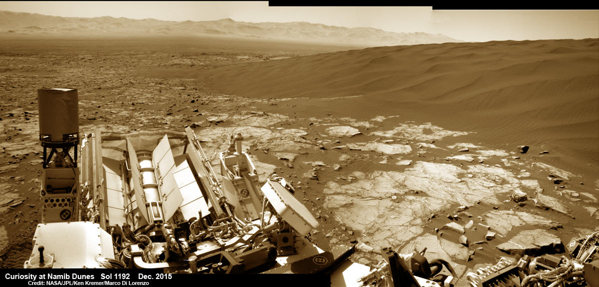
The dark dunes skirt the northwestern flank of Mount Sharp and lie on the alien road of Curiosity’s daring trek up the lower portion of the layered Martian mountain.
Beside dunes, the local terrain is also replete with a bonanza of outcrops of bedrock and mineral veins for targeted science observations.
“Curiosity will acquire ChemCam and Mastcam observations of targets to characterize some of the local bedrock and veins,” Edgar elaborated. “We’ll also take a Mastcam stereo mosaic of “Namib Dune” to better understand the morphology of the ripples and grain flow.”
“We’ll use ChemCam to assess the composition and grain size of a ripple. Then we’ll use Mastcam to image the brink of the dune and its slipface to characterize the dune morphology. We’ll also use Mastcam to document an outcrop with an unusual purple hue.”
Initial imaging results are already promising and much more is upcoming.
“The Mastcam images that we took earlier this week are coming down now, and they reveal a lot of great details about the dune morphology,” says Edgar.
“Mastcam will do a mosaic of the slip face of Namib dune, and a stereo observation of the target “Nadas” to study the shape of the alcoves on the very crest of the dune,” MSL team member Ryan Anderson added.
“Mastcam will also watch for changes in a patch of nearby sand, as well as a couple of locations on the dune slip face.”
While Earthlings and their families are gathering together and engrossed in the Christmas holiday cheer, there will be little rest for ‘The Martian’ Curiosity. The science team has planned out and uploaded more than a week of science observations to run through the New Year’s holiday.
“We’re in a great location to study “Namib Dune” so there is plenty of good science to be done,” says Anderson.
In addition, Curiosity is dumping the recently acquired rock drill sample from “Greenhorn” onto the surface to analyze the residue further, “before the martian wind blows it away.”
As of today, Sol 1203, December 25, 2015, Curiosity has driven over 7 miles (11.5 kilometers) and taken over 291,700 amazing images.
Stay tuned here for Ken’s continuing Earth and planetary science and human spaceflight news.


Curiosity’s Traverse Map Through Sol 1196. This map shows the route driven by NASA’s Mars rover Curiosity through Sol 1196, December, 18, 2015. Numbering of the dots along the line indicate the sol number of each drive. North is up. The scale bar is 1 kilometer (~0.62 mile). From Sol 1194 to Sol 1196, Curiosity had driven a straight line distance of about 97.41 feet (29.69 meters). The base image from the map is from the High Resolution Imaging Science Experiment Camera (HiRISE) in NASA’s Mars Reconnaissance Orbiter. Credit: NASA/JPL-Caltech/Univ. of Arizona
Merry Christmas back at you Curiosity. May you work for many years to come!
That first image explains so much! In an earlier release, the nearby dunes looked HUGE but without a perspective to actual size. This shot puts a more distinguishing scale on the dunes and shows how tall they actually are, at least along the boundary.