
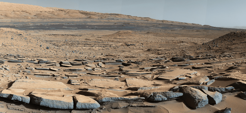
A view from the “Kimberley” formation on Mars taken by NASA’s Curiosity rover. The strata in the foreground dip towards the base of Mount Sharp, indicating flow of water toward a basin that existed before the larger bulk of the mountain formed. This image was taken by the Mast Camera (Mastcam) on Curiosity on Sol 580 of the mission and has been “white balanced” to adjust for the lighting on Mars make the sky appear light blue. Credits: NASA/JPL-Caltech/MSSS
Story/imagery updated[/caption]
Hot on the heels of NASA’s groundbreaking announcement on Sept. 28 of the discovery that “liquid water flows intermittently” across multiple spots on the surface of today’s Mars, scientists leading NASA’s Curiosity rover mission have confirmed that an ancient lake once filled the Gale Crater site which the robot has been methodically exploring since safely landing back in August 2012 near the base of a layered mountain known as Mount Sharp.
The new research finding from the Curiosity team was just published in the journal Science on Friday, Oct. 9, and boosts the chances that alien life may have taken hold in the form of past or present day Martian microbes.
The article is titled “Wet Paleoclimate of Mars Revealed by Ancient Lakes at Gale Crater,” with John Grotzinger, the former project scientist for the Mars Science Laboratory (MSL) mission at the California Institute of Technology in Pasadena, as lead author of the new report.
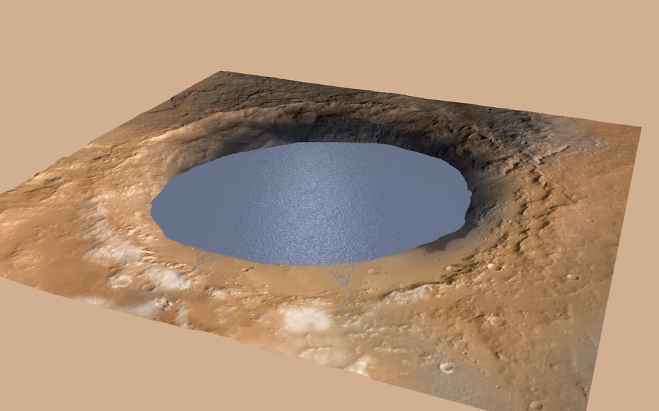
The new study is coauthored by four dozen team members intimately involved in Curiosity’s ongoing exploits and “confirmed that Mars was once, billions of years ago, capable of storing water in lakes over an extended period of time.”
“Observations from the rover suggest that a series of long-lived streams and lakes existed at some point between about 3.8 to 3.3 billion years ago, delivering sediment that slowly built up the lower layers of Mount Sharp,” said Ashwin Vasavada, current MSL project scientist at NASA’s Jet Propulsion Laboratory in Pasadena, California, and co-author of the new report, in a statement.
Over the past three years, the Curiosity Mars Science Laboratory rover has been traversing the floor of Gale Crater investigating scores of different rocks and outcrops with her suite of state-of-the-art instruments, and painstakingly analyzing drill samples cored from their interiors with a pair of chemistry labs to elucidate the history of Mars based on NASA’s “follow the water” mantra.
The soundness of NASA Mars exploration strategy has repeatedly borne fruit and is now validated by overwhelming measurements gathered during Curiosity’s epic Martian trek confirming the existence of a lake where Mount Sharp now stands.
Exploring the sedimentary layers of Mount Sharp, which towers 3.4 miles (5.5 kilometers) into the Martian sky, is the primary destination and goal of the rovers long term scientific expedition on the Red Planet.
Since the nail biting touchdown on Aug. 5, 2012, Curiosity has been on a path towards the sedimentary layers at the lower reaches of Mount Sharp at the center of Gale Crater.

The car sized robot arrived at the foothills of Mount Sharp a year ago in September 2014, marking the start of the mountains formal investigation.
But the origin of Mount Sharp has been up for debate.
With the new data, researchers believe that the ancient lake helped fill Gale Crater with sediments deposited in layers over time that formed the foundation for Mount Sharp which now dominates the center of the crater.
“What we thought we knew about water on Mars is constantly being put to the test,” said Michael Meyer, lead scientist for NASA’s Mars Exploration Program at NASA Headquarters in Washington.
“It’s clear that the Mars of billions of years ago more closely resembled Earth than it does today. Our challenge is to figure out how this more clement Mars was even possible, and what happened to that wetter Mars.”
Mars was far wetter and warmer and possessed a much more massive atmosphere billions of years ago than it does today.
Gale Crater lake existed long before Mount Sharp ever formed during that period billions of years ago when the Red Planet was far warmer and wetter.
“Paradoxically, where there is a mountain today there was once a basin, and it was sometimes filled with water,” said Grotzinger, in a statement.
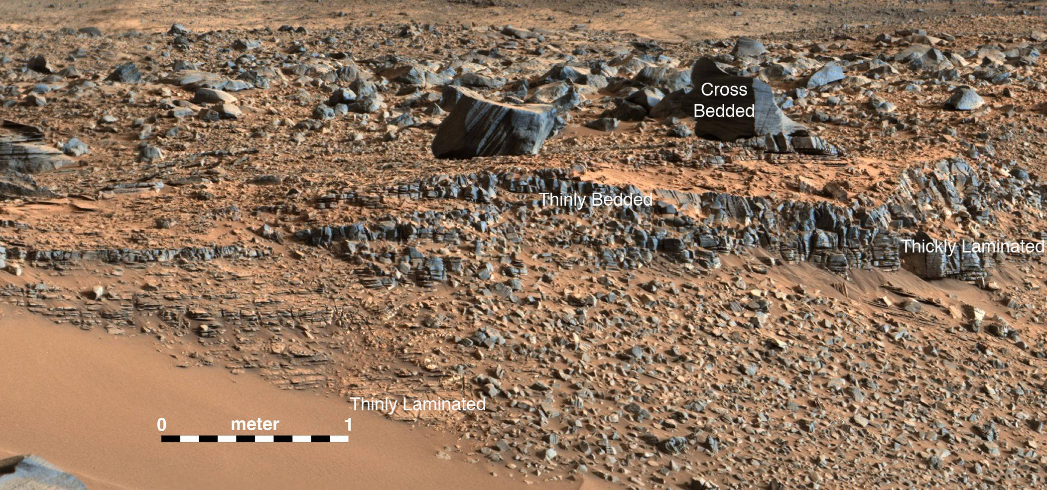
“We see evidence of about 250 feet (75 meters) of sedimentary fill, and based on mapping data from NASA’s Mars Reconnaissance Orbiter and images from Curiosity’s camera, it appears that the water-transported sedimentary deposition could have extended at least 500 to 650 feet (150 to 200) meters above the crater floor.”
Indeed there is additional evidence that the sedimentary deposits from interaction with water may be as thick as one-half mile (800 meters) above the crater floor. However beyond that there is no evidence of hydrated strata further up Mount Sharp.
But for reasons we are still trying to decipher and comprehend, Mars underwent radical climactic change between 3 and 4 billion years ago and was transformed from an ancient wet world, potentially hospitable to life, to a cold, dry desiccated world, rather inhospitable to life, that exists today.

Unlocking the mysteries, mechanisms and time periods of Mars climate change, loss of a thick atmosphere, ability to sustain liquid surface water and searching for organic compounds and for evidence of past or present habitable zones favorable to life are the questions driving NASA’s Mars Exploration program
Curiosity has already accomplished her primary objective of discovering a habitable zone on the Red Planet – at the Yellowknife Bay area – that contains the minerals necessary to support microbial life in the ancient past when Mars was far wetter and warmer billions of years ago.

“We have tended to think of Mars as being simple,” Grotzinger mused. “We once thought of the Earth as being simple too. But the more you look into it, questions come up because you’re beginning to fathom the real complexity of what we see on Mars. This is a good time to go back to reevaluate all our assumptions. Something is missing somewhere.”
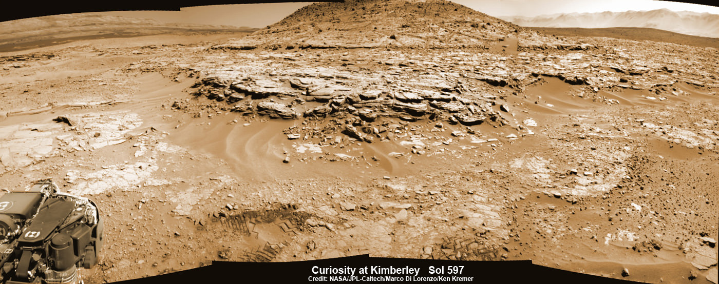
Curiosity recently celebrated 1000 Sols of exploration on Mars on May 31, 2015 – detailed here with our Sol 1000 mosaic by Marco Di Lorenzo and Ken Kremer also featured at Astronomy Picture of the Day on June 13, 2015.
As of today, Sol 1129, October 10, 2015, she has driven some 6.9 miles (11.1 kilometers) kilometers and taken over 274,000 amazing images.
Curiosity is at the vanguard of Earth’s fleet of seven robotic missions paving the path for NASA’s plans to send humans on a ‘Journey to Mars’ in the 2030s.
Stay tuned here for Ken’s continuing Earth and planetary science and human spaceflight news.
Very interesting article. Sorry to nitpick but …”As of today, Sol 112902, October 10, 2015″…
would put Curiosity on Mars for 308 (earth) years.
Why are we looking for life on Mars maybe we used to live on Mars that we will never know but the sun does shine.
Oooooooh…KAY…..
??? What hallucinogens are you currently experimenting with, Glenn?
The point of looking for life on Mars is if unequivocal evidence of current or past life on Mars is found, we can then be more confident in assuming life will naturally arise many places in the universe where conditions allow the chemical reactions that lead to self-replicating entities, i.e, life occurs.
If life is found on Mats & it’s the same DNA based life as on earth it’s from the same source & tells us nothing about the probability of life elsewhere in the universe. If it’s found and is different from our life, that will be a monumental discovery.
Spacer, Yes it could IF life is based on the same DNA Everywhere…
If the central mountain has sediment layers, where did it come from? I presume people had thought it was a crater-forming side affect rebound but now that seems impossible.
Wikipedia: ~ “The mountain appears to be an enormous mound of *eroded* sedimentary layers sitting on the central peak of Gale. It rises 5.5 km (18,000 ft) above the northern crater floor and 4.5 km (15,000 ft) above the southern crater floor, higher than the southern crater rim. The sediments may have been laid down over an interval of 2 billion years, and *may have once completely filled the crater*. Some of the *lower sediment layers may have originally been deposited on a lake bed*, while observations of possibly cross-bedded strata in the upper mound suggest *aeolian* (wind erosion) processes. However, this issue is debated, and the *origin of the lower layers remains unclear*. If katabatic wind deposition played the predominant role in the emplacement of the sediments, as suggested by reported 3 degree radial slopes of the mound’s layers, erosion would have come into play largely to place an upper limit on the mound’s growth”.
This is what interests me most:
“… there is additional evidence that the sedimentary deposits from interaction with water may be as thick as one-half mile (800 meters) above the crater floor. However beyond that there is no evidence of hydrated strata further up Mount Sharp.”
According to the Wikipedia article on Mount Sharp (https://en.wikipedia.org/wiki/Mount_Sharp), “it rises 5.5 km (18,000 ft [3.4 miles]) above the northern crater floor and 4.5 km (15,000 ft [2.8 miles]) above the southern crater floor, higher than the southern crater rim.”
So how on earth (sorry, how on Mars) were the upper layers formed? Not by impact, not by hydraulic sedimentation. The only possible mechanism left is aeolian sedimentation. It seems incredible to me, as a non-geologist, that 3.7 – 4.7 km of rock could have been created by windborne sediments! Have aeolian sedimentary rocks of comparable thickness been found on Earth?
Manned space program and searching for aliens are total waste.
By 2025 there will be computer smart as humans(singularity). Computers will design ever smarter computers and within few decades, smartphone size. Computers can be made from just about any material including carbon(graphine). Similar things should happen in other part of universe. So, if some smart computer being that can invent smarter computer being, why would they bother with humans lol.
Within 10-20 years, we all want to be a cyborg too. Simple microchip will eliminate wallet, watch, credit card, smart phone, etc. Eventually direct visual link that bypasses the eye.
By Tokyo Olympic in 2020, there will be self driving cars on road. Ridiculous liability awards make it impractical in USA for a while.
google “real7777 wordpress”
First major thing would be factory self replicating on the moon and satellite mirror that can send sun light to solar panels during 14 day dark cycle. Then whole solar system will be converted to computers.
I’m sure of one thing: I don’t wish to be a part of your “dream”, real7777. Keep it for yourself and Welcome to your nightmares! I am the last optimist standing 😉
Please don’t advertise your blog here, real777. This is a place to discuss space exploration and scientific developments, not a forum for debating the merits of futurist predictions.
A mystery wrapped in an enigma? I wonder how long it will take for us to understand what happened to make Mars what it is today? Far longer if we don’t go there and take a closer look! I’m an ‘itchy old guy’ who thought we’d be there by now! Of course throughout history greed and politics constantly got in the way. So what’s new?
I miss the euphoria of the Apollo days… Let’s go back to the Moon then head for Mars!
Well Said Aqua!!
I share your itch and frustration, Aqua. When I think back to the sci-fi visions, predictions and illustrations of what life would be like around the year 2000 and I compare it to the depressing lack of progress and even retrograde tendencies I see around me (e.g. demented religious fanatics oppressing women and trying to drag entire nations back into the Middle Ages; teaching of creationism and intelligent design in US schools; 25% of young Americans believing NASA faked the moon landings), I feel intense nostalgia for the heady and free-thinking Apollo era when anything and everything seemed possible.
Whatever happened to the pioneering, visionary spirit and the exemplary leadership of real men like JFK, von Braun, Chris Kraft and Gene Kranz? The banal, repetitive, money-wasting farting around on the ISS bores and irritates the hell out of me. To Mars! Light that candle! Failure is not an option!
“The strata in the foreground dip towards the base of Mount Sharp, indicating flow of water toward a basin that existed before the larger bulk of the mountain formed.”
This statement below the dipping strata photo is complete nonsense.
Sedimentary layers are laid down flat and later tilted due to tectonic uplift. In this case uplift at the crater margin or down thrust in the center.
That is geology 101.
The flow of water whether in or out of the crater has nothing to do with present day sedimenrary dip layers. That has to do with tectonic upthusting or down thrusting.
It is very irritating to read garbage statements like this which means the author/authors have not the slightest concept of geology.
Chris Landau(geologist)
Hi Chris. I’m no geologist, but what if there was an existing large impact crater whose floor was bowl-shaped (i.e. a curved slope towards the centre) and was subsequently flooded over and over again with alluvial outwash. Wouldn’t you then get a series of sedimentary beds, each of roughly uniform thickness, that followed the original curve? Or is that impossible? Are sedimentary beds always laid down perfectly horizontally, whatever the shape of the underlying rock surface? Please educate and enlighten me!
The Central peak of Gale is higher than the Craters Edge because of the Initial Impact that made the Crater wind may have added a little to the height of Mount Sharp by dropping Dust Particles over Millions of years its not such a great mystery..Also the simulated picture of Gale Crater with a lake in it is wrong because the Central Peak has always been in the Middle then Water then the Rim Mountains..
In an earlier post I stated that the creation of Mt. Sharp, aka Aeolis Mons, is quite the antithetical enigma. I have been searching for the elevation of Mt. Sharp to compare it to the rim(s) elevation. That is to say, how far (If so?) does the mountain rise above the rim?
Central mountains within craters are quite common. These are thought to be caused by impact reflex. This is where the central mountain range ‘springs upward’ in response to the enormous energy of the impact and subsequently uplifts molten terrain that solidifies as it cools near the center of the impact. This is not unlike the splash a raindrop makes when it hits water… Would that be more easily accomplished if the impact area is composed of more molten or fluidic substrates?
There goes that mystery wrapped in an enigma thang again…
If Aeolis Mons (Mt Sharp) is composed solely of approximately horizontal beds of sedimentary rock (as I understand it to be), it cannot possibly have been formed by elastic rebound following an impact.
Yes it could contain horizontal beds of sedimentary rock from rebound there are places on Earth where Stress has forced up multiple layers,Gibraltar is one of them another is the Gower Peninsula in Wales If the impact came in on an Angle the Strata beneath can be pushed up in one large mass.
OK – obviously, pressure from beneath (e.g. due to a magma chamber) could uplift a sedimentary rock formation. But if the pressure was due to the impact that formed Gale Crater, I don’t see how previously deposited sedimentary layers could be preserved, even if the angle of impact was highly oblique. Also, if the impact was highly oblique, the crater wouldn’t be roughly circular with fairly uniform crater rim height, would it?
The Curiosity team are indicating that all the sedimentary layers in and around Aeolis Mons were deposited AFTER the impact crater was formed. The lower layers (which may have entirely filled the crater) would have been deposited due to successive floodings of the crater with alluvial outwash; the upper layers would have been deposited by aeolian processes, as evinced by cross-bedding. The mountain would have been carved out and heightened by aeolian processes.
I don’t know. Those sure look the remains of slate tiles to me, which can only mean one thing – it’s an ancient structure left behind by a Martian civilization! The evidence is undebunkable! 😉
Hmmm.. OTAY… inspires a Sci-Fi short? An “Ancient Martian” civilization. Dang.. now THERE’s and interesting topic. Imagine a race on Mars that through it’s interactions with other interstellar civilizations.. makes an enemy. That enemy vaporizes the surface of Mars. Those “in the know” have the where with all to escape the conflagration and fly to the ‘just barely evolved/acceptable’ Earth and we are their descendants. Lets talks about.. shhhh… don’t let them know we are baaaaack. Even though… over the millennia, those remote civilizations may have expired or ascended?
For the alleged deity’s sake, Matt, desist from fueling the hallucinations of the (paranoid) delusional. There are nutcases out there who will seize on your remark and blow it out of all proportion. Stick to hard science.
robst247, If anyone is Paranoid or Delusional its you .. Matt was making whats called a Joke! Dahh!
He knows UFO, he’s worried that I might encourage the paranoid and delusional. But as I said to him, if you can’t make fun of them, what the heck good are they? 😉
I know there are nutjobs out there, hence why I made the joke. This sounds exactly like the kind of thing some such person would say, so I said it ironically to mock the very idea.
Also, I hardly think it will be seized upon by anyone, as such people need no encouragement. And if we can’t make fun of the absurd, if we choose to live in fear of it, we’ve already lost.
Matt — sure, man, I realised you were being ironic, and my comment was tongue-in-cheek. I didn’t intend it to be taken seriously. Keep up the excellent work. I really appreciate your articles. 😉
Cheers, Rob
Dear UFOsMOTHER,
FYI: My comment was tongue-in-cheek. (I’m English, you see – as dry as a camel’s arse in a sandstorm.) You took it seriously. No problem. Thanks for pointing out what I had already surmised (and was attempting to respond to in kind): i.e. that Matt’s words were in jest.
Ciao, Roberto