Dawn Does Dramatic Fly Over of Ceres, Enters Lower Mapping Orbit: Video
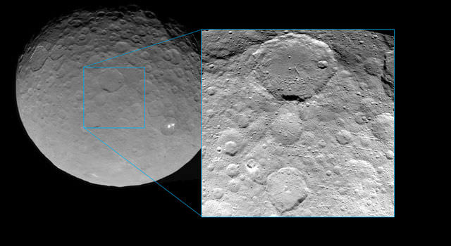
This image of Ceres was taken by NASA's Dawn spacecraft on May 7, 2015, from a distance of 8,400 miles (13,600 kilometers). Credit: NASA/JPL-Caltech/UCLA/MPS/DLR/IDA
Video caption: This new video animation of Ceres was created from images taken by NASA’s Dawn spacecraft at altitudes of 8,400 miles (13,600 kilometers) and 3,200 miles (5,100 kilometers) away. Vertical dimension has been exaggerated by a factor of two and a star field added. Credit: NASA/JPL-Caltech/UCLA/MPS/DLR/IDA
Scientists leading NASA’s Dawn mission to dwarf planet Ceres have just released a brand new animated video showing a dramatic fly over of the heavily cratered world featuring its mysterious bright spots whose exact origin and nature remain elusive.
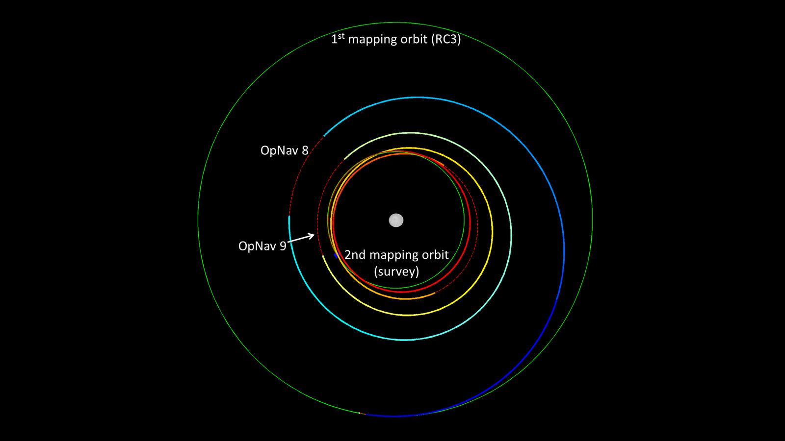
Meanwhile, the venerable probe has just successfully entered its new and lower mapping orbit on June 3 from which researchers hope to glean hordes of new data to unravel the secrets of the bright spots and unlock the nature of Ceres origin and evolution.
Pockmarked Ceres is an alien world unlike any other in our solar system.
“Dawn completed the maneuvering to reach its second mapping orbit and stopped ion-thrusting on schedule. Since May 9, the spacecraft has reduced its orbital altitude from 8,400 miles (13,600 kilometers) to 2,700 miles (4,400 kilometers),” reported Marc Rayman, Dawn Chief Engineer/ Mission Director of NASA’s Jet Propulsion Laboratory, Pasadena, California.
“As Dawn flew 2,700 miles (4,400 kilometers) over Ceres’ north pole on June 5 that marked the beginning of the new mapping phase, and Dawn began taking photos and making other measurements on schedule.”
Each orbit of Dawn around Ceres at this second science mapping orbit lasts 3.1 days.
The new video was created by the research team based on observations of Ceres that were taken from Dawn’s initial mapping orbit, at an altitude of 8,400 miles (13,600 kilometers), as well as the most recent navigational images taken from 3,200 miles (5,100 kilometers), according to NASA.
It is based on data from over 80 images captured by Dawn’s framing cameras which were provided The German Aerospace Center (DLR) and Max Planck Institute for Solar System Research in Göttingen, Germany.
The images were used to provide a three-dimensional video view. The vertical dimension is exaggerated by a factor of two in the video.
“We used a three-dimensional terrain model that we had produced based on the images acquired so far,” said Dawn team member Ralf Jaumann of the German Aerospace Center (DLR), in Berlin.
“They will become increasingly detailed as the mission progresses — with each additional orbit bringing us closer to the surface.”
Imagery of the mysterious bright spots show them to seemingly be sheets of many spots of water ice, and not just single huge patches. The famous duo of ice spots are located inside the middle of a 57 miles (92 kilometers) wide crater situated in Ceres northern hemisphere.
Dawn is an international science mission managed by NASA’s Jet Propulsion Laboratory, Pasadena, California. The trio of science instruments are from the US, Germany and Italy.
The framing camera was provided by the Max Planck Institute for Solar System Research, Göttingen, Germany and the German Aerospace Center (DLR).
Dawn will spend most if June at this second mapping orbit before firing up the ion engines and spiraling yet lower for a mission expected to last until at least June 2016.
Stay tuned here for Ken’s continuing Earth and planetary science and human spaceflight news.
Recent Posts
Here’s Why We Should Put a Gravitational Wave Observatory on the Moon
Scientists detected the first long-predicted gravitational wave in 2015, and since then, researchers have been…
TESS Finds its First Rogue Planet
Well over 5,000 planets have been found orbiting other star systems. One of the satellites…

There are Four Ways to Build with Regolith on the Moon
Over the last few years I have been renovating my home. Building on Earth seems…
Purple Bacteria — Not Green Plants — Might Be the Strongest Indication of Life
Astrobiologists continue to work towards determining which biosignatures might be best to look for when…
See the Southern Ring Nebula in 3D
Planetary nebula are some of nature's most stunning visual displays. The name is confusing since…
Hubble Has Accidentally Discovered Over a Thousand Asteroids
The venerable Hubble Space Telescope is like a gift that keeps on giving. Not only…