
Come on, admit it, you’ve spent hours gazing at Google Maps and Google Earth, finding your house, school, and seeing what various building and features look like from space. And after today’s launch of DigitalGlobe’s WorldView-1, the resolution is going to get even better. In fact, it’s going to have the highest resolution permitted by the US government to be installed on a commercial satellite – half a metre (20 inches).
How much better is this? Currently, the highest resolution commercial satellite images are taken by DigitalGlobe’s Quickbird. It was originally slated to have a 1-metre resolution, but engineers were able to get better images by adjusting its orbit so that it flies a little closer to the ground. It’s been able acquire images at 61 cm (about 2 feet). So, WorldView-1 will be able beat this resolution; the rumours say it’s even better, but it’s not permitted to take higher resolution images because of government regulations.
But more importantly, WorldView-1 can take a mountain of images, collecting up to 500,000 square kilometres (200,000 square miles) of imagery every day – 4.5 times the rate of any previous system. This means it’ll be able to quickly fill in regions missed by other satellites.
The satellite will have many customers, including Google and the US Government, but it’ll also be used by any number of urban planners, real estate developers and environmental monitors.
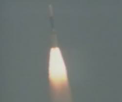
A Delta 2 rocket carrying WorldView-1 lifted off today at 11:35 PDT from Vandenberg Air Force Base in California. The rocket launched right on time, and there were no reported problems at the time that I wrote this up (it’s about 81 km altitude and climbing quickly).
This is just the first of two missions. WorldView-2 will be launched in 2008.
Original Source: Ball Aerospace