
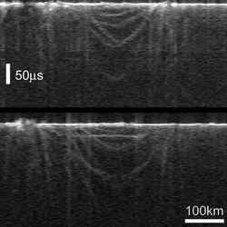
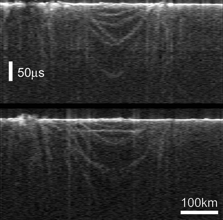
MARSIS ‘radargrams’ of buried basin on Mars. Image credit: ESA Click to enlarge
For the first time in the history of planetary exploration, the MARSIS radar on board ESA’s Mars Express has provided direct information about the deep subsurface of Mars.
First data include buried impact craters, probing of layered deposits at the north pole and hints of the presence of deep underground water-ice.
The subsurface of Mars has been so far unexplored territory. Only glimpses of the Martian depths could be deduced through analysis of impact crater and valley walls, and by drawing cross-sections of the crust deduced from geological mapping of the surface.
With measurements taken only for a few weeks during night-time observations last summer, MARSIS – the Mars Advanced Radar for Subsurface and Ionospheric Sounding – is already changing our perception of the Red Planet, adding to our knowledge the missing ‘third’ dimension: the Martian interior.
First results reveal an almost circular structure, about 250 km in diameter, shallowly buried under the surface of the northern lowlands of the Chryse Planitia region in the mid-latitudes on Mars. The scientists have interpreted it as a buried basin of impact origin, possibly containing a thick layer of water-ice-rich material.
To draw this first exciting picture of the subsurface, the MARSIS team studied the echoes of the radio waves emitted by the radar, which passed through the surface and then bounced back in the distinctive way that told the ‘story’ about the layers penetrated.
These echo structures form a distinctive collection that include parabolic arcs and an additional planar reflecting feature parallel to the ground, 160 km long. The parabolic arcs correspond to ring structures that could be interpreted as the rims of one or more buried impact basins. Other echoes show what may be rim-wall ‘slump blocks’ or ‘peak-ring’ features.
The planar reflection is consistent with a flat interface that separates the floor of the basin, situated at a depth of about 1.5 to 2.5 km, from a layer of overlying different material. In their analysis of this reflection, scientists do not exclude the intriguing possibility of a low-density, water-ice-rich material at least partially filling the basin.
“The detection of a large buried impact basin suggests that MARSIS data can be used to unveil a population of hidden impact craters in the northern lowlands and elsewhere on the planet,” says Jeffrey Plaut, Co-Principal Investigator on MARSIS. “This may force us to reconsider our chronology of the formation and evolution of the surface.”
MARSIS also probed the layered deposits that surround the north pole of Mars, in an area between 10? and 40? East longitude. The interior layers and the base of these deposits are poorly exposed. Prior interpretations could only be based on imaging, topographic measurements and other surface techniques.
Two strong and distinct echoes coming from the area correspond to a surface reflection and subsurface interface between two different materials. By analysis of the two echoes, the scientists were able to draw the likely scenario of a nearly pure, cold water-ice layer thicker than 1 km, overlying a deeper layer of basaltic regolith. This conclusion appears to rule out the hypothesis of a melt zone at the base of the northern layered deposits.
To date, the MARSIS team has not observed any convincing evidence for liquid water in the subsurface, but the search has only just begun. “MARSIS is already demonstrating the capability to detect structures and layers in the subsurface of Mars which are not detectable by other sensors, past or present,” says Giovanni Picardi, MARSIS Principal Investigator.
“MARSIS holds exciting promise to address, and possibly solve, a number of open questions of major geological significance,” he concluded.
Original Source:ESA Portal