Curiosity Demonstrates New Capability to Scan 360 Degrees for Life Giving Water – and is Widespread

The science team guiding NASA’s Curiosity Mars Science Lab (MSL) rover have demonstrated a new capability that significantly enhances the robots capability to scan her surroundings for signs of life giving water – from a distance. And the rover appears to have found that evidence for water at the Gale Crater landing site is also more widespread than prior indications.

The powerful Mastcam cameras peering from the rovers head can now also be used as a mineral-detecting and hydration-detecting tool to search 360 degrees around every spot she explores for the ingredients required for habitability and precursors to life.

Researchers announced the new findings today (March 18) at a news briefing at the Lunar and Planetary Science Conference in The Woodlands, Texas.

“Some iron-bearing rocks and minerals can be detected and mapped using the Mastcam’s near-infrared filters,” says Prof. Jim Bell, Mastcam co-investigator of Arizona State University, Tempe.

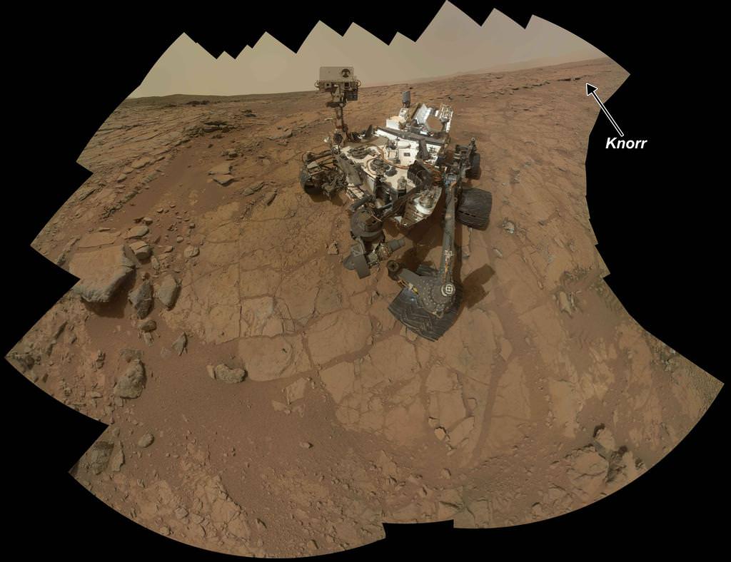
Bell explained that scientists used the filter wheels on the Mastcam cameras to run an experiment by taking measurements in different wavelength’s on a rock target called ‘Knorr’ in the Yellowknife Bay area were Curiosity is now exploring. The rover recently drilled into the John Klein outcrop of mudstone that is crisscrossed with bright veins.

Curiosity accomplished Historic 1st drilling into Martian rock at John Klein outcrop on Feb 8, 2013 (Sol 182), shown in this context mosaic view of the Yellowknife Bay basin taken on Jan. 26 (Sol 169) where the robot is currently working. The robotic arm is pressing down on the surface at John Klein outcrop of veined hydrated minerals – dramatically back dropped with her ultimate destination; Mount Sharp. Credit: NASA/JPL-Caltech/Ken Kremer/Marco Di Lorenzo
Curiosity accomplished Historic 1st drilling into Martian rock at John Klein outcrop on Feb 8, 2013 (Sol 182), shown in this context mosaic view of the Yellowknife Bay basin taken on Jan. 26 (Sol 169) where the robot is currently working. The robotic arm is pressing down on the surface at John Klein outcrop of veined hydrated minerals – dramatically back dropped with her ultimate destination; Mount Sharp. Credit: NASA/JPL-Caltech/Ken Kremer (kenkremer.com)/Marco Di Lorenzo

Researchers found that near-infrared wavelengths on Mastcam can be used as a new analytical technique to detect the presence of some but not all types of hydrated minerals.

“Mastcam has some capability to search for hydrated minerals,” said Melissa Rice of the California Institute of Technology, Pasadena.

“The first use of the Mastcam 34 mm camera to find water was at the rock target called “Knorr.”

“With Mastcam, we see elevated hydration signals in the narrow veins that cut many of the rocks in this area. These bright veins contain hydrated minerals that are different from the clay minerals in the surrounding rock matrix.”

Mastcam thus serves as an early detective for water without having to drive up to every spot of interest, saving precious time and effort.

Hydration in Veins and Nodules at ‘Knorr’ rock in Yellowknife bay. At different locations on the surface of the same rock, scientists can use the Mast Camera (Mastcam) on Curiosity to measure the amount of reflected light at a series of different wavelengths to obtain spectral information about composition.  The inset photograph shows two locations on a rock target called "Knorr," where Mastcam spectral measurements were made: A light-toned vein and part of the host rock. The main graph shows the spectra recorded at those two points, with increasing wavelengths of visible light and near-infrared light from left to right, and with increasing intensity of reflectance from bottom to top. The bright vein shows greater reflectance through the range of wavelengths assessed. The shapes of the two curves also differ, especially where the vein spectrum dips in the near-infrared wavelengths. The range of wavelengths included in box-outlined portion of the vein spectrum is shown at the top of the group of reference spectra to the right. These reference spectra show how the dip in reflectance at those wavelengths in the vein material corresponds to dips in those wavelengths in several types of hydrated minerals -- minerals that have molecules of water bound into their crystalline structure, including hydrated calcium-sulfates. Mastcam is not sensitive to all hydrated minerals, however, including many phyllosilicates. Credit: NASA/JPL-Caltech/MSSS/ASU
Hydration in Veins and Nodules at ‘Knorr’ rock in Yellowknife bay. At different locations on the surface of the same rock, scientists can use the Mast Camera (Mastcam) on Curiosity to measure the amount of reflected light at a series of different wavelengths to obtain spectral information about composition. The inset photograph shows two locations on a rock target called “Knorr,” where Mastcam spectral measurements were made: A light-toned vein and part of the host rock. The main graph shows the spectra recorded at those two points, with increasing wavelengths of visible light and near-infrared light from left to right, and with increasing intensity of reflectance from bottom to top. The bright vein shows greater reflectance through the range of wavelengths assessed. The shapes of the two curves also differ, especially where the vein spectrum dips in the near-infrared wavelengths. The range of wavelengths included in box-outlined portion of the vein spectrum is shown at the top of the group of reference spectra to the right. These reference spectra show how the dip in reflectance at those wavelengths in the vein material corresponds to dips in those wavelengths in several types of hydrated minerals — minerals that have molecules of water bound into their crystalline structure, including hydrated calcium-sulfates. Mastcam is not sensitive to all hydrated minerals, however, including many phyllosilicates. Credit: NASA/JPL-Caltech/MSSS/ASU

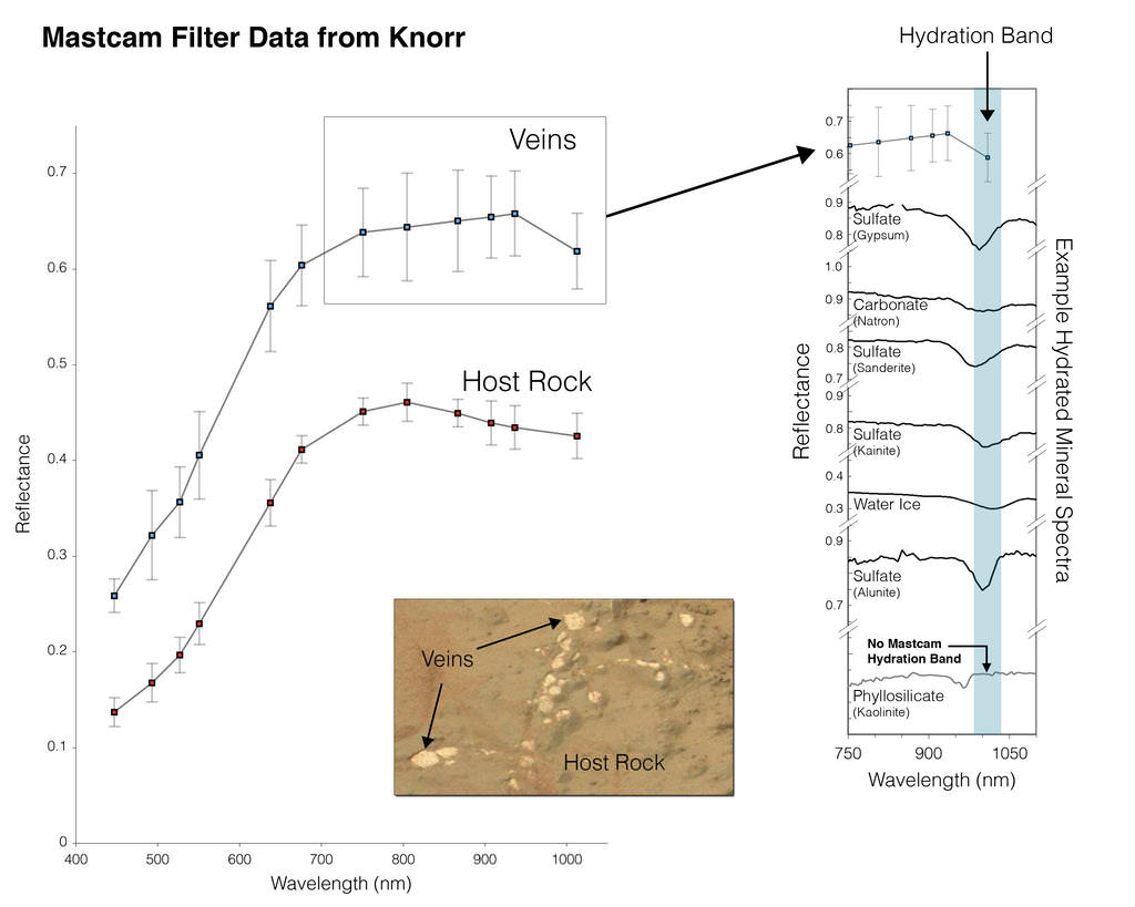
But Mastcam has some limits. “It is not sensitive to the hydrated phyllosilicates found in the drilling sample at John Klein” Rice explained.

“Mastcam can use the hydration mapping technique to look for targets related to water that correspond to hydrated minerals,” Rice added. “It’s a bonus in searching for water!”

The key finding of Curiosity thus far is that the fine-grained, sedimentary mudstone rock at the Yellowknife Bay basin possesses a significant amount of phyllosilicate clay minerals; indicating an environment where Martian microbes could once have thrived in the distant past.

“We have found a habitable environment which is so benign and supportive of life that probably if this water was around, and you had been on the planet, you would have been able to drink it,” said John Grotzinger, the chief scientist for the Curiosity Mars Science Laboratory mission at the California Institute of Technology in Pasadena, Calif.

Ken Kremer

Hydration Map, Based on Mastcam Spectra for ‘Knorr’ rock target shows coded map of the amount of mineral hydration indicated by a ratio of near-infrared reflectance intensities measured by Curiosity. The color scale on the right shows the assignment of colors for relative strength of the calculated signal for hydration. The map shows that the stronger signals for hydration are associated with pale veins and light-toned nodules in the rock. The Mastcam observations were conducted during Sol 133 (Dec. 20, 2012). The width of the area shown in the image is about 10 inches (25 centimeters). Credit: NASA/JPL-Caltech/MSSS/ASU

3 Replies to “Curiosity Demonstrates New Capability to Scan 360 Degrees for Life Giving Water – and is Widespread”

  1. This info is way double extra groovy cool and an incredibly creative way to use Curiosity’s instrumentation. Some think all or most of Earth’s water came from comets? An alternative theory says that the water and ices we see on Earth, Mars, Jupiter’s moons, Saturn’s moons and beyond may have come from the proto-stellar nebula during the formative phases of planetary accretion. I will weigh in on the side that says Sol has experienced multiple episodes of nucleosynthesis wherein Hydrogen and Oxygen outflow dominated the solar wind. Carry that idea further and see where ‘ice ages’ may have been created during similar yet later stages of solar fusion evolution? Live and learn! Tvist and turn!

  2. You might want to apply a little human editing to the article. Obviously it’s been spell-checked, but spell-checkers don’t understand what they’re checking. There are missing apostrophes, as well as one where it shouldn’t be; there’s a “were” where you wanted a “where”; the end of paragraph 2 needs to be edited for sense; the title needs a fix too.

Comments are closed.