
Massive floodwaters on Mars gouged a channel more than 600 miles (1,000 kilometers) long, making a trench that was hidden to scientists until now because volcanic flows buried it underground.
Erupting groundwater, perhaps triggered by a volcano or an earthquake, forced water across the surface during the past 500 million years. This carved a trench about 62 miles (100 kilometers) wide; it would take runners more than two marathons (at 26 miles each) to cross the expanse.
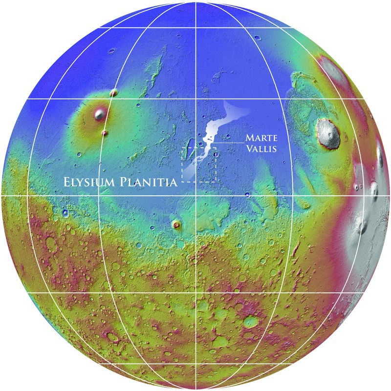
Later, as volcanoes erupted in Mars’ Elysium Planitia plain, lava flows covered the channel. The trench, now called Marte Vallis, finally came to light from radar measurements by an orbiting spacecraft. The results were published in the journal Science Thursday.
“This work demonstrates the importance of orbital sounding radar in understanding how water has shaped the surface of Mars,” stated Gareth A. Morgan, the paper’s lead author and a geologist at the National Air and Space Museum’s Center for Earth and Planetary Studies.
Scientists stumbled on the trench using the radar capabilities of NASA’s Mars Reconnaissance Orbiter and its Italian-made Mars SHAllow RADar sounder, also known as SHARAD, designed to pick up ice and water underground. The instrument has a horizontal resolution of between 0.3 and 3 kilometers (between 2/10 of a mile and almost 2 miles) horizontally and 15 meters (about 50 feet) vertically.
SHARAD revealed that the largest or main channel was 370 feet (113 meters) deep, which is skyscraper height.
“This is comparable with the depth of incision of the largest known megaflood on Earth, the Missoula floods,” the paper stated, referring to bursts of water that swept across western North America after the last ice age, some 12,000 to 18,000 years ago.
Mars today is considered pretty dry, save for the water that is locked in the ice caps at the north and south poles. In recent years, however, several spacecraft and rovers revealed ancient signs of water at various points in the past.
The Curiosity rover found a streambed where hip-deep water flowed, while the Spirit and Opportunity rovers analyzed rocks such as hematite “blueberries” that form in wet conditions. From above, orbiters with NASA and the European Space Agency regularly take pictures of ancient channels and water carvings on the surface.
This is the first time scientists found a trench underground, however.
“Understanding Marte Vallis is essential to our assessment of recent Mars hydrologic activity during a period otherwise considered to be cold and dry,” the paper stated.
Sources: Smithsonian, Science
“… a trench about 62 miles (100 kilometers) wide; it would take runners more than two marathons (at 26 miles each) to cross the expanse.”
In fact, advanced research is now estimating it would take said runners approximately 2.3846 marathons, though questions still linger about the feasibility of such a feat while wearing a spacesuit.
In other news, survey shows most people can comprehend two-digit integers.
This is a VERY interesting finding! It implies underground aquafirs and/or river systems may be present on Mars! There MAY be enough residual volcanic heating for liquid water to be present? Lava tubes or underground flow channels are oft times mentioned as locations for habitat(s)… earthly and martian.
One day while idly fishing in the underground river behind the hab module.. I got a BIG BITE! When I pulled my catch to shore I was amazed to find that I’d caught a rather reptilian yet squid-like creature wearing a breathing apparatus and dive suit!
What would provoke water to erupt from deep inside a body? Well, an intense magnetic field? Ten Tesla levitates water.
Magnetic field?
Maybe start with something simple, like pressure caused by a big mass that lays on top of it.
I had to down vote the originating comment for unnecessary and obscene use of EU tropes. =D
The same volcanic terrain that liquified the ice would indeed put pressure from above (the almost concurrent lava infilling the flood trenches) but also put the crustal strain that opened up the originating cracks of Cerberus Fossae. (See my previous comment.)
Another(?) massive flood event surfaced on the Red Planet, when skies might have been densely blue, and an Ice Age gripped the world through? Martian analogs of huge flood events on EARTH, over Western North America (and elsewhere). Adjusting for gravity differences, revealing how catastrophic hydrology sculpts landscapes. Erosional evidence of large-scale flood-water sculpting on our planet, as seen from satellite images (affording the same perspective views as of the Martian surface from space, in way of comparative planetology). Do frozen records of Martian floods, reveal more than realized, “how water has shaped the surface” of our planet as well? Topographical moldings of epic marine modeling? Not only in the “Missoula floods”, but mega-flooding over the Greater Grand Canyon plateaus, the Black Sea basin, the English Channel …
“[T]he largest or main channel was 370 feet (113 meters) deep, which is skyscraper height.” For an observer witnessing the towering wall of water and ice(?) rising fearfully over the horizon plain(?), that would have been a frightful sight! The heaving waters bulldozing through inundated terrain, with breaking waves thundering over hills(?), rolling down with the sound of 10,000 locomotives on the move, generating ground tremors from the mass movement!
Thrilling to imagine time-machine tour of Mars, back then(?), when extensive glaciers may have laced hemispheres, and impressive ice sheets mantled swaths of the globe. Bold panoramas, shadowed with streaming plumes from Olympian Volcanoes. Hulking masses belching enormous columns of smoke into shuddering skies, billowing from huge craters raised so high. Volcanic summits in the clouds, with rise of stars, fire-fountains aglow at night , as segments of the world’s crust shook with harmonic tremors passing below gentle rivers, beneath wave-caressed coastlines, and under expanses of sleeping snow.
A melodramatic dream of mind? Or, one awesome reality of epic time!
Interesting, though I had to do some digging to understand the context.
The suggested origin of the massive outflow is Cerberus Fossae. It is also responsible for more obvious flood channels, such as the Athabasca Valles. Those are also lava covered, with the simplest suggestion that “the water flood and lava flows are essentially contemporaneous”. [ http://en.wikipedia.org/wiki/Athabasca_Valles ]
But the Marte Wallis is the most dramatic flood feature.
The volcanic center responsible for the magma center that ripped the Cerberus Fossae apart is the Elysium volcanic province, situated on Elysium Planitia. Interestingly, it isn’t even the youngest or largest province. “Elysium Mons is only about one-fifth the volume of Arsia Mons.” [ http://en.wikipedia.org/wiki/Volcanology_of_Mars#Elysium_volcanic_province ]
Even more interestingly, this is the region that InSight will visit 2016 to measure its, and more importantly, Mars’ seismological activity. “These faults, known as the Cerberus Fossae (see figure 2) are around 1000km from the proposed landing site. This figure is taken from a paper by Roberts et al. which shows evidence that these faults are likely still active today.” [ http://areology.org/2013/01/07/seismicity-of-mars/ ]