A vertically exaggerated view of Mars’ north polar cap. Researchers with The University of Texas at Austin and the University of Arizona estimate that if melted, the massive ice deposits discovered in this region would cover the planet in 1.5 meters (5 feet) of water. Credit: SA/DLR/FU Berlin; NASA MGS MOLA Science Team
One of the most profound similarities between Earth and Mars, one which makes it a popular target for research and exploration, is the presence of water ice on its surface (mainly in the form of its polar ice caps). But perhaps even more interesting is the presence of glaciers beneath the surface, which is something scientists have speculated about long before their presence was confirmed.
These caches of subsurface water could tell us a great deal about Martian history, and could even be an invaluable resource if humans ever choose to make Mars their home someday. According to a recent study by a pair of scientists from the Universities of Texas at Austin and Arizona, there are also layers of ice beneath the northern polar ice cap that could be the largest reservoir of water on the planet.
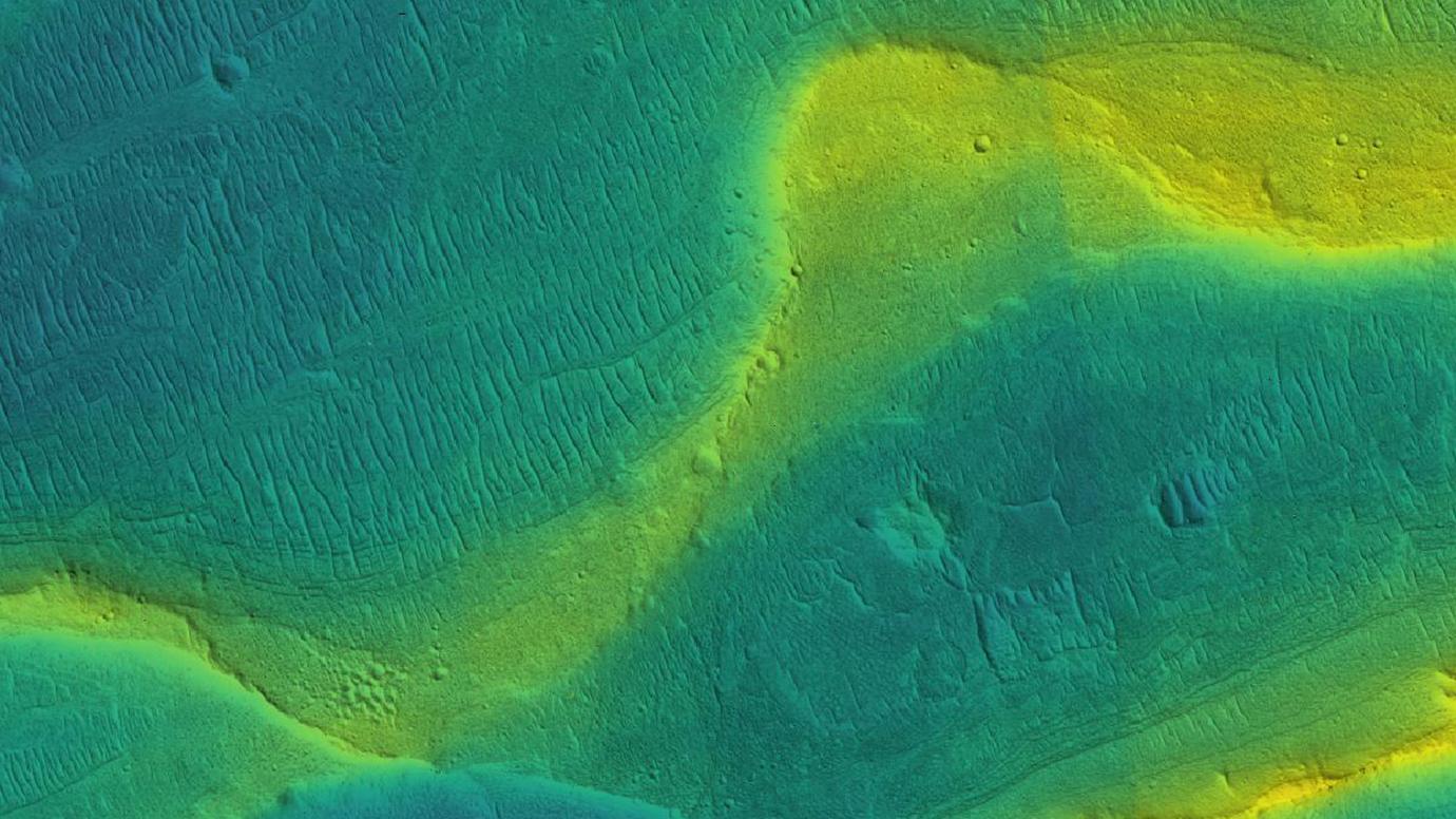
A photo of a preserved river channel on Mars. The color is overlaid to show elevation, with blue being low and yellow being high elevation. Image Credit: NASA/JPL/Univ. Arizona/UChicago
The ancient climate of Mars is a mystery to scientists. Even with all we’ve learned about Mars, it’s still difficult to explain how lakes and rivers existed. A new study shows that Martian rivers were swollen with runoff and that they flowed far later into the planet’s history than previously thought.
The question is, how did the Martian climate create these conditions?
A splitting slope streak on Mars captured by High Resolution Imaging Science Experiment (HiRISE). Image Id: ESP_053518_1955. Credit: NASA/JPL/University of Arizona
Since they were first observed in the 1970s by the Viking missions, the slope streaks that periodically appear along slopes on Mars have continued to intrigue scientists. After years of study, scientists still aren’t sure exactly what causes them. While some believe that “wet” mechanisms are the culprit, others think they are the result of “dry” mechanisms.
Luckily, improvements in high-resolution sensors and imaging capabilities – as well as improved understanding of Mars’ seasonal cycles – is bringing us closer to an answer. Using a terrestrial analog from Bolivia, a research team from Sweden recently conducted a study that explored the mechanisms for streak formation and suggest that wet mechanisms appear to account for more, which could have serious implications for future missions to Mars.
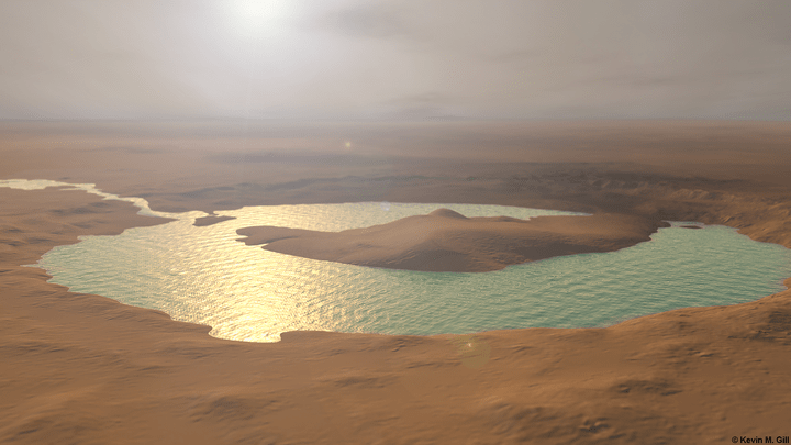
Artist rendition of how the "lake" at Gale Crater on Mars may have looked millions of years ago. Credit and copyright: Kevin Gill.
Roughly 4.2 billion years ago, Mars was a much different place than it is today. It’s atmosphere was thicker and warmer and its surface much wetter. Unfortunately, the planet’s atmosphere was stripped away by solar wind over the next 500 million years, causing the surface to become so cold and dry that it makes Antarctica look balmy by comparison!
As a result, most of Mars’ water is currently locked away in its polar ice caps. But billions of years ago, water still flowed freely across the surface, forming ancient rivers and lakes. In fact, new research led by The University of Texas at Austin indicates that sometimes these lakes would fill so fast that they would overflow, causing massive floods that had a drastic impact on the surface.
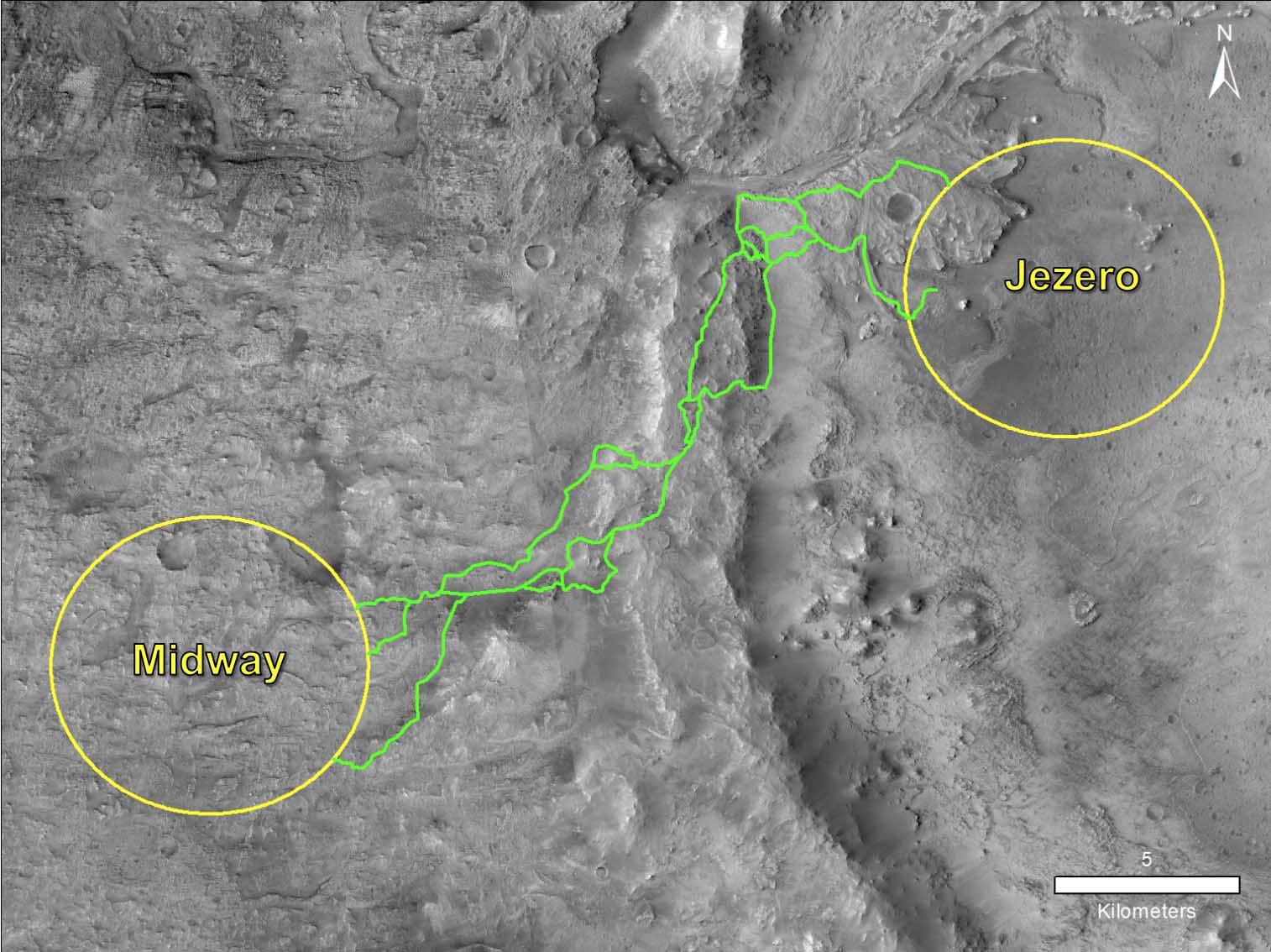
One solution could be to have the Mars 2020 rover drive from one potential landing site toward another favorite. Credit: NASA/JPL-Caltech
In the summer of 2020, NASA’s Mars 2020rover will launch from Cape Canaveral and commence its journey towards the Red Planet. Once it arrives on the Martian surface, the rover will begin building on the foundation established by the Opportunity and Curiosityrovers. This will include collecting samples of Martian soil to learn more about the planet’s past and determine if life ever existed there (and still does).
Up until now, though, NASA has been uncertain as to where the rover will be landing. For the past few years, the choice has been narrowed down to three approved sites, with a fourth added earlier this year for good measure. And after three days of intense debate at the recent fourth Landing Site Workshop, scientists from NASA’s Mars Exploration Program held a non-binding vote that has brought them closer to selecting a landing site.
Artist's impression of water under the Martian surface. Credit: ESA/Medialab
The possibility that life could exist on Mars has captured the imagination of researchers, scientists and writers for over a century. Ever since Giovanni Schiaparelli (and later, Percival Lowell) spotted what they believed were “Martian Canals” in the 19th century, humans have dreamed of one day sending emissaries to the Red Planet in the hopes of finding a civilization and meeting the native Martians.
While the Mariner and Viking programs of the 1960s and 70s shattered the notion of a Martian civilization, multiple lines of evidence have since emerged that indicate how life could have once existed on Mars. Thanks to a new study, which indicates that Mars may have enough oxygen gas locked away beneath its surface to support aerobic organisms, the theory that life could still exist there has been given another boost.
NASA image of the Martian surface, showing a rock formation that was the result of interactions with water. Credit: NASA.
For some time, scientists have known that Mars was once a much warmer and wetter environment than it is today. However, between 4.2 and 3.7 billion years ago, its atmosphere was slowly stripped away, which turned the surface into the cold and desiccated place we know today. Even after multiple missions have confirmed the presence of ancient lake beds and rivers, there are still unanswered questions about how much water Mars once had.
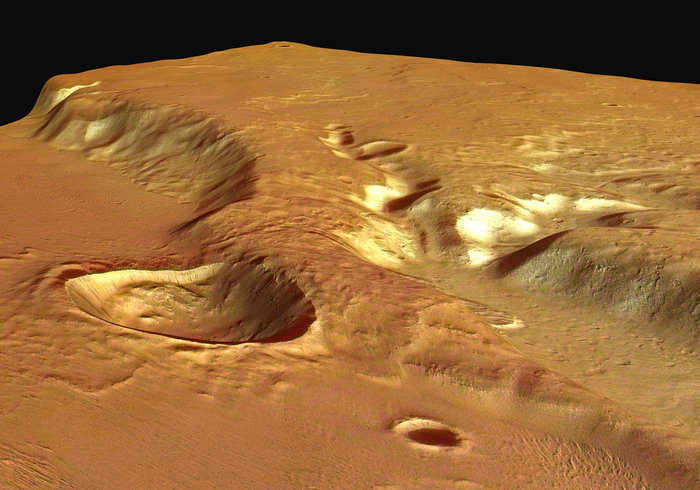
One of the most important unanswered questions is whether or not large seas or an ocean ever existed in the northern lowlands. According to a new study by an international team of scientists, the Hypanis Valles ancient river system is actually the remains of a river delta. The presence of this geological feature is an indication that this river system once emptied into an ancient Martian sea in Mars’ northern hemisphere.
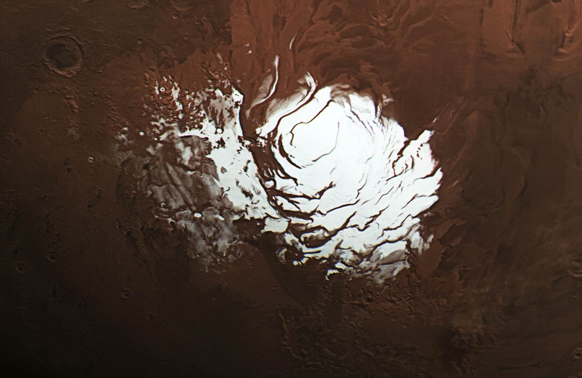
Mars’ south polar ice cap. Credit: ESA / DLR / FU Berlin /
According to evidence gathered by multiple robotic orbiters, rovers, and landers over the course of several decades, scientists understand that Mars was once a warmer, watery place. But between 4.2 and 3.7 billion years ago, this began to change. As Mars magnetic field disappeared, the atmosphere slowly began to be stripped away by solar wind, leaving the surface the cold and dry and making it impossible for water to exist in liquid form.
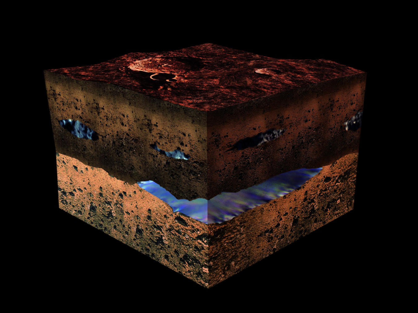
While much of the planet’s water is now concentrated in the polar ice caps, scientists have speculated some of Mars’ past water could still be located underground. Thanks to a new study by a team of Italian scientists, it has now been confirmed that liquid water still exists beneath Mars’ southern polar region. This discovery has put an end to a fifteen-year mystery and bolstered the potential for future missions to Mars.
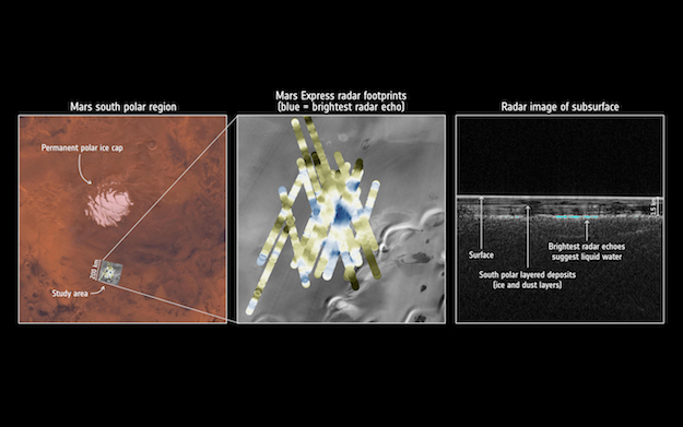
Radar detection of water under the south pole of Mars. Credit: ESA/NASA/JPL/ASI/Univ. Rome
So far, robotic missions have revealed considerable evidence of past water on Mars. These include dried-out river valleys and gigantic outflow channels discovered by orbiters, and evidence of mineral-rich soils that can only form in the presence of liquid water by rovers and landers. Early evidence from the ESA’s Mars Express probe has also showed that water-ice exists at the planet’s poles and is buried in the layers interspersed with dust.
However, scientists have long suspected that liquid water could exist beneath the polar ice caps, much in the same way that liquid water is believed to underlie glaciers here on Earth. In addition, the presence of salts on Mars could further reduce the melting point of subsurface water and keep it in a liquid state, despite the sub-zero temperatures present on both the surface and underground.
For many years, data from the Mars Express’Mars Advanced Radar for Subsurface and Ionosphere Sounding (MARSIS) instrument – which has been used to study the southern polar region – has remained inconclusive. Like all ground-penetrating radar, this instrument relies on radar pulses to map surface topography and determine the properties of the materials that lie beneath the surface.
Luckily, after considerable analysis, the study team was able to develop new techniques that allowed them to collect enough high-resolution data to confirm the presence of liquid water beneath the southern ice cap. As Andrea Cicchetti, the MARSIS operations manager and a co-author on the new paper, indicated:
“We’d seen hints of interesting subsurface features for years but we couldn’t reproduce the result from orbit to orbit, because the sampling rates and resolution of our data was previously too low. We had to come up with a new operating mode to bypass some onboard processing and trigger a higher sampling rate and thus improve the resolution of the footprint of our dataset: now we see things that simply were not possible before.”
Water detection under the south pole of Mars. Credit: Context map: NASA/Viking; THEMIS background: NASA/JPL-Caltech/Arizona State University; MARSIS data: ESA/NASA/JPL/ASI/Univ. Rome; R. Orosei et al 2018
What they found was that the southern polar region is made of many layers of ice and dust down to a depth of about 1.5 km over a 200 km-wide area, and featured an anomalous area measuring 20-km wide. As Roberto Orosei, the principal investigator of the MARSIS experiment and lead author of the paper, explained in a recent ESA press release:
“This subsurface anomaly on Mars has radar properties matching water or water-rich sediments. This is just one small study area; it is an exciting prospect to think there could be more of these underground pockets of water elsewhere, yet to be discovered.”
After analyzing the properties of the reflected radar signals and taking into account the composition of the layered deposits and expected temperature profiles below the surface, the scientists concluded that the 20-km wide feature is an interface between the ice and a stable body of liquid water. For MARSIS to be able to detect such a patch of water, it would need to be at least several tens of centimeters thick.
These findings also raise the possibility of there being life on Mars, both now and in the past. This is based on research that found microbial life in Lake Vostok, which is located some 4 km (2.5 mi) below the ice in Antarctica. If life can thrive in salty, subglacial environments on Earth, then it is possible that they could survive on Mars as well. Determining if this is the case will be the purpose of existing and future missions to Mars.
The MARSIS instrument on the Mars Express is a ground penetrating radar sounder used to look for subsurface water and ice. Credit: ESA
As Dmitri Titov, one of the Mars Express project scientist, explained:
“The long duration of Mars Express, and the exhausting effort made by the radar team to overcome many analytical challenges, enabled this much-awaited result, demonstrating that the mission and its payload still have a great science potential. This thrilling discovery is a highlight for planetary science and will contribute to our understanding of the evolution of Mars, the history of water on our neighbour planet and its habitability.”
The Mars Express launched on June 2nd, 2003, and will celebrate 15 years in orbit of Mars by December 25th this year. In the coming years, it will be joined by the ESA’s ExoMars 2020 mission, NASA’s Mars 2020 Rover, and a number of other scientific experiments. These missions will pave the way for a potential crewed mission, which NASA is planning to mount by the 2030s.
If there is indeed liquid water to be found on Mars, it will go a long way towards facilitating future research and even an ongoing human presence on the surface. And if there is still life on Mars, the careful research of its ecosystems will help address the all-important question of how and when life emerged in the Solar System.
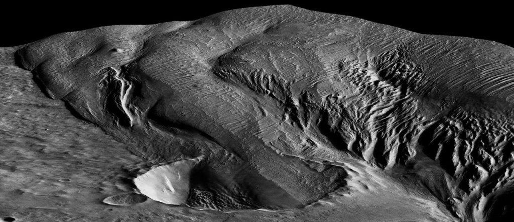
A 13-kilometer (8-mile) diameter crater being infilled by the Medusae Fossae Formation. Credit: High Resolution Stereo Camera/European Space Agency.
Scientists first observed the Medusae Fossae Formation (MFF) in the 1960s, thanks to the efforts of the Mariner spacecraft. This massive deposit of soft, sedimentary rock extends for roughly 1,000 km (621 mi) along the equator and consists of undulating hills, abrupt mesas, and curious ridges (aka. yardangs) that appear to be the result of wind erosion. What’s more, an unusual bump on top of this formation also gave rise to a UFO conspiracy theory.
Needless to say, the formation has been a source of scientific curiosity, with many geologists attempting to explain how it could have formed. According to a new study from Johns Hopkins University, the region was the result of volcanic activity that took place on the Red Planet more than 3 billion years ago. These findings could have drastic implications for scientists’ understanding of Mars’ interior and even its past potential for habitability.
Perspective view of Medusa Fossae looking south-east. Copyright: ESA/DLR/FU Berlin (G. Neukum)
Ojha’s past work includes finding evidence that water on Mars occurs in seasonal brine flows on the surface, which he discovered in 2010 as an undergraduate student. Lewis, meanwhile, has dedicated much of his academic carreer to the in-depth study of the nature of sedimentary rock on Mars for the sake of determining what this geological record can tell us about that planet’s past climate and habitability.
As Ojha explained, the study of the Medusa Fossae Formation is central to understanding Mars geological history. Much like the Tharsus Montes region, this formation was formed at a time when the planet was still geologically active. “This is a massive deposit, not only on a Martian scale, but also in terms of the solar system, because we do not know of any other deposit that is like this,” he said.
Basically, sedimentary rock is the result of rock dust and debris accumulating on a planet’s surface and becoming hardened and layered over time. These layers serve as a geological record, indicating what types of processes where taking place on the surface at the time that the layers were deposited. When it comes to the Medusae Fossae Formation, scientists were unsure whether wind, water, ice or volcanic eruptions were responsible for the deposits.
In the past, radar measurements were made of the formation that suggested that Medusae Fosssae had an unusual composition. However, scientists were unsure whether the formation was made of highly porous rock or a mixture of rock and ice. For the sake of their study, Ojha and Lewis used gravity data from various Mars orbiters to measure the formation’s density for the first time.
An isolated hill in the Medusae Fossae Formation. The effect of wind erosion on this hill is evident by its streamlined shape. Credit: High Resolution Stereo Camera/European Space Agency
What they found was that the rock is unusually porous and about two-thirds as dense as the rest of the Martian crust. They also used radar and gravity data to show that the Formation’s density was too great to be explained by the presence of ice. From this, they concluded that the heavily-porous rock had to have been deposited by volcanic eruptions when Mars was still geologically active – ca. 3 billion years ago.
As these volcanoes exploded, casting ash and rock into the atmosphere, the material would have then fallen back to the surface, building up layers and streaming down hills. After enough time, the ash would have cemented into rock, which was slowly eroded over time by Martian winds and dust storms, leaving the Formation scientists see there today. According to Ojha, these new findings suggest that Mars’ interior is more complex than previously thought.
While scientists have known for some time that Mars has some volatiles – i.e. water, carbon dioxide and other elements that become gas with slight increases in temperature – in its crust that allow for periodic explosive eruptions to occur on the surface, the kind of eruption needed to create the Medusa Fossae region would have been immense. This indicates that the planet may have massive amounts of volatiles in its interior. As Ojha explained:
“If you were to distribute the Medusae Fossae globally, it would make a 9.7-meter (32-foot) thick layer. Given the sheer magnitude of this deposit, it really is incredible because it implies that the magma was not only rich in volatiles and also that it had to be volatile-rich for long periods of time.”
According to Ojha and Lewis’ study, the eruption that created the Medusa Fossae Formation would have covered Mars in a global ocean. Image: ESO/M. Kornmesser, via N. Risinger
In addition, this activity would have had a drastic impact on Mars’ past habitability. Basically, the formation of the Medusae Fossae Formation would have occurred during a pivotal point in Mars’ history. After the eruption occurred, massive amounts of carbon dioxide and (most likely) methane would have been ejected into the atmosphere, causing a significant greenhouse effect.
In addition, the authors indicated that the eruption would have ejected enough water to cover Mars in a global ocean more than 9 cm (4 inches) in thickness. This resulting greenhouse effect would have been enough to keep Mars’ surface warm to the point that the water would remain in a liquid state. At the same time, the expulsion of volcanic gases like hydrogen sulfide and sulfur dioxide would have altered the chemistry of Mars’ surface and atmosphere.
All of this would have had a drastic impact on the planet’s potential habitability. What’s more, as Kevin Lewis indicated, the new study shows that gravity surveys have the potential to interpret Mars’ geological record. “Future gravity surveys could help distinguish between ice, sediments and igneous rocks in the upper crust of the planet,” he said.
Studying Mars surface features and geological history is a lot like peeling an onion. With every layer we peel back, we get another piece of the puzzle, which together adds up to a rich and varied history. In the coming years and decades, more robotic missions will be studying the Red Planet’s surface and atmosphere in preparation for an eventual crewed mission by the 2030s.
All of these missions will allow us to learn more about Mars warmer, wetter past and whether or not may have existed there at some time (or perhaps, still does!)
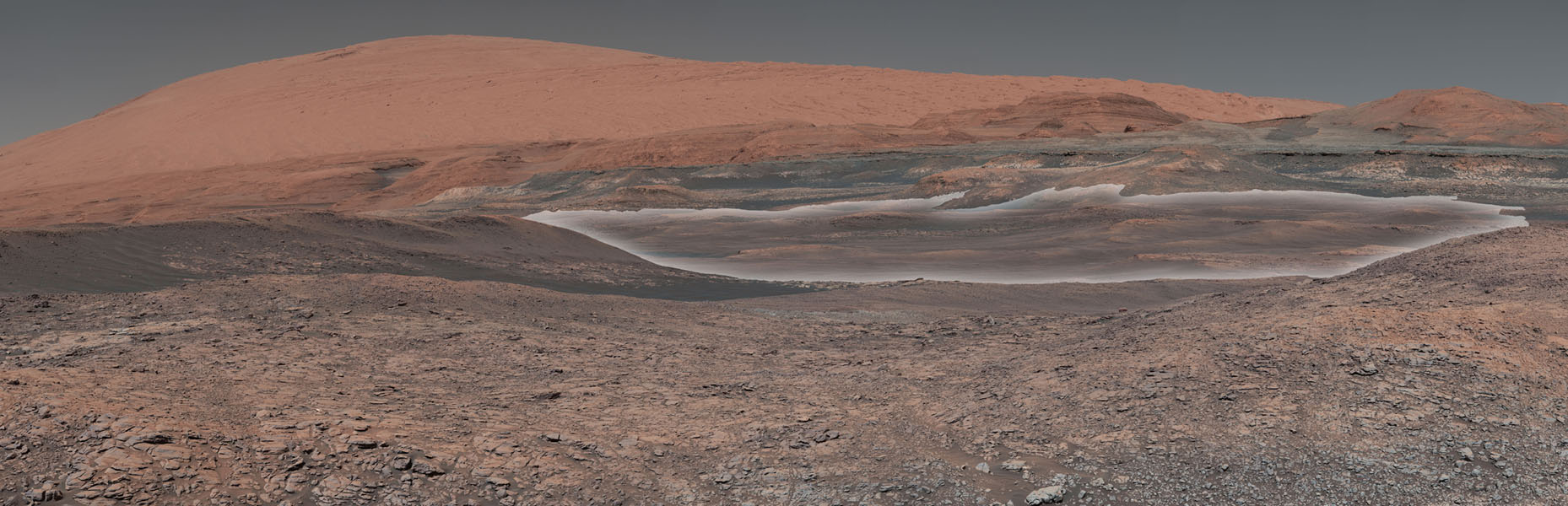
This mosaic taken by NASA's Mars Curiosity rover looks uphill at Mount Sharp, which Curiosity has been climbing since 2014. Highlighted in white is an area with clay-bearing rocks that scientists are eager to explore; it could shed additional light on the role of water in creating Mount Sharp. Credit: NASA/JPL-Caltech/MSSS
Since it landed on Mars in 2012, the Curiosity rover has made some rather startling scientific discoveries. These include the discovery of methane and organic molecules, evidence of how it lost its ancient atmosphere, and confirming that Mars once had flowing water and lakes on its surface. In addition, the rover has passed a number of impressive milestones along the way.
In fact, back in January of 2018, the rover had spent a total of 2,000 Earth days on Mars. And as of March 22nd, 2018, NASA’s Mars Curiosity rover had reached its two-thousandth Martian day (Sol) on the Red Planet! To mark the occasion, NASA released a mosaic photo that previews what the rover will be investigating next (hint: it could shed further light on whether or not Mars was habitable in the past).
The image (shown at top and below) was assembled from dozens of images taken by Curiosity‘s Mast Camera (Mastcam) on Sol 1931 (back in January). To the right, looming in the background, is Mount Sharp, the central peak in the Gale Crater (where Curiosity landed back in 2012). Since September of 2014, the rover has been climbing this feature and collecting drill samples to get a better understanding of Mars’ geological history.
Image of the mosaic taken by NASA’s Mars Curiosity rover in January of 2018 (Sol 1931). Click to enlarge. Credit: NASA/JPL-Caltech/MSSS
In the center of the image is the rover’s next destination and scientific target. This area, which scientists have been studying from orbit, is rich in clay minerals, which indicates that water once existed there. In the past, the Curiosity rover found evidence of clay minerals on the floor of the Gale Crater. This confirmed that the crater was a lake bed between 3.3 and 3.8 billion years ago.
Mount Sharp, meanwhile, is believed to have formed from sedimentary material that was deposited over a period of about 2 billion years. By examining patches of clay minerals that extend up the mountain’s side, scientists hope to gain insight into the history of Mars since then. These include how long water may have persisted on its surface and how the planet made the transition to the cold and desiccated place it is today.
The Curiosity science team is eager to analyze rock samples pulled from the clay-bearing rocks seen in the center of the image, and not just because of the results they could provide. Recently, the science team developed a new drilling technique to compensate for the failure of a faulty motor (which allows the drill to extend and retract). When the rover begins to drill again, it will be the first time since December 2016.
All told, the rover has spent a total of about 2055 Earth days (5 years and 230 days), which means Curiosity now ranks third behind the Opportunity (5170 days; 5031 sols) and the Spirit rovers (2269 days; 2208 sols) in terms of total time spent on Mars. Since it arrived on Mars in 2012, Curiosity has also traveled a total distance of 18.7 km (11.6 mi) and studied more than 180 meters (600 feet) vertical feet of rock.
But above all, Curiosity‘s greatest achievement has been the discovery that Mars once had all the necessary conditions and chemical ingredients to support microbial life. Based on their findings, Curiosity‘s international science team has concluded that habitable conditions must have lasted for at least millions of years before Mars’ atmosphere was stripped away.
Finding the evidence of this, and how the transition occurred, will not only advance our understanding of the history of Mars, but of the Solar System itself. It also might provide clues as to how Mars could be made into a warmer, wetter environment again someday!