Curiosity Arrives in a Salty Region of Mars. Was it Left Over From a Dying Sea?

A Mastcam image from the Mars Science Laboratory Curiosity rover on Sol 3609 of its mission. Credit: NASA/JPL-Caltech/MSSS/Kevin M. Gill.

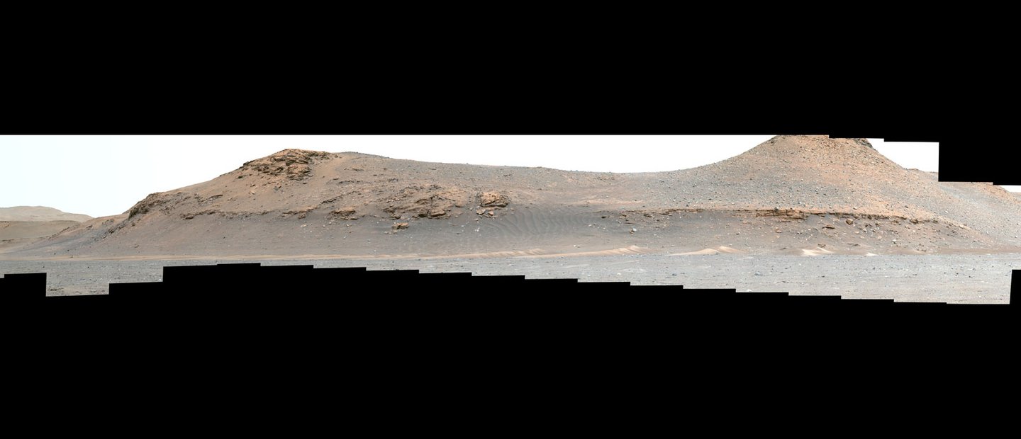
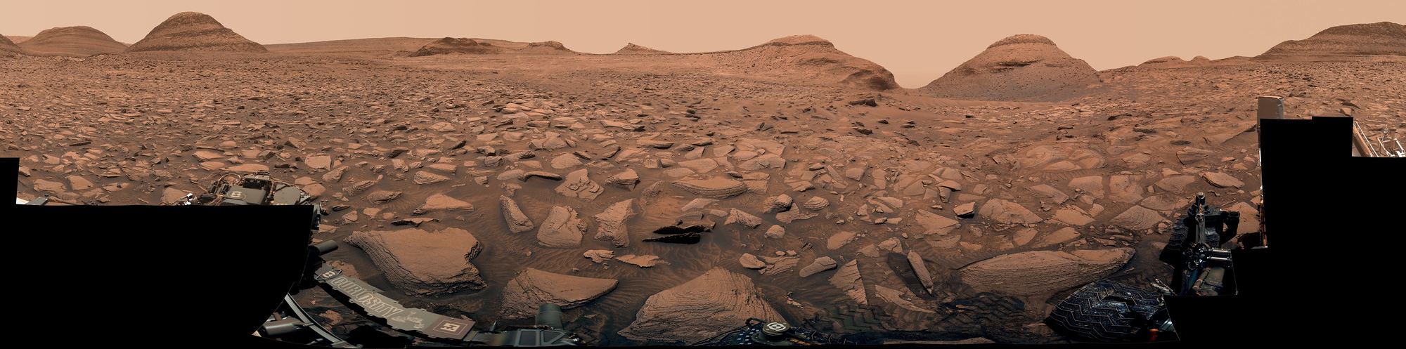
The Curiosity rover has now reached its primary target on Mount Sharp on Mars, the mountain in the middle of Gale Crater the rover has been climbing since 2014. This target is not the summit, but a region over 600 meters (2,000 feet) up the mountain that planetary geologists have long anticipated reaching.

Known as the “sulfate-bearing unit,” the region is a boundary between the rocks that saw a lot of water in their history and those that didn’t; a possible shoreline, if you will. That boundary is already providing insights into Mars’ transition from a wet planet to dry, filling in a key gap in the understanding of the planet’s history.  

Continue reading “Curiosity Arrives in a Salty Region of Mars. Was it Left Over From a Dying Sea?”

Underground Liquid Water Detected on Mars? Maybe not

This image from NASA’s Mars Reconnaissance Orbiter shows the edge of the Martian South Pole Layered Deposit. Credit: NASA/JPL-Caltech/University of Arizona

When planning crewed missions to Mars, the key phrase is “follow the water.” When astronauts set down on the Red Planet in the next decade, they will need access to water to meet their basic needs. Following the water is also crucial to our ongoing exploration of Mars and learning more about its past. While all of the water on the Martian surface exists as ice today (the majority locked away in the polar ice caps), it is now known that rivers, lakes, and an ocean covered much of the planet billions of years ago.

Determining where this water went is essential to learning how Mars underwent its historic transformation to become the dry and cold place it is today. Close to twenty years ago, the ESA’s Mars Express orbiter made a huge discovery when it detected what appeared to be a massive deposit of water ice beneath the southern polar region. However, recent findings by a team of researchers from Cornell University indicate that the radar reflections from the South Pole Layered Deposit (SPLD) may be the result of geological layering.

Continue reading “Underground Liquid Water Detected on Mars? Maybe not”

China’s Zhurong Rover Looks Deep Underground and Sees Layers From Multiple Floods on Mars

Mars exploration has been ongoing for decades at this point, and some regions of the planet have become more interesting than others. Of particular interest is a basin known as Utopia Planitia. It was the site of the Viking-2 landing, one of the first-ever successful missions to Mars. From data collected during that mission, scientists developed a theory that the crater that formed Utopia might have been the site of an ancient ocean. New results from China’s Zhurong rover point to an even more exciting past – repeated flooding.

Continue reading “China’s Zhurong Rover Looks Deep Underground and Sees Layers From Multiple Floods on Mars”

Mars Might Have Been Covered in Lakes in the Ancient Past

Artist's impression of Mars during the Noachian Era. Credit: Ittiz/Wikipedia Commons

Ever since robotic explorers began visiting the Red Planet during the 1960s and 70s, scientists have puzzled over Mars’ surface features. These included flow channels, valleys, lakebeds, and deltas that appear to have formed in the presence of water. Since then, dozens of missions have been sent to Mars to explore its atmosphere, surface, and climate to learn more about its warmer, wetter past. In particular, scientists want to know how long water flowed on the surface of Mars and whether it was persistent or periodic in nature.

The ultimate purpose here is to determine whether rivers, streams, and standing bodies of water existed long enough for life to emerge. So far, missions like Curiosity and Perseverance have gathered volumes of evidence that show how hundreds of large lakebeds once dotted the Martian landscape. But according to a new study by an international team of researchers, our current estimates of Mars’ surface water may be a dramatic understatement. Based on a meta-analysis of years’ worth of satellite data, the team argues that ancient lakes may have once been a very common feature on Mars.

Continue reading “Mars Might Have Been Covered in Lakes in the Ancient Past”

Mars did Have Moving Glaciers, but They Behaved Differently in the Planet's Lower Gravity

Glacial landscapes on Axel Heiberg Island (Canadian Arctic Archipelago) showing typical (glaciers) and atypical (subglacial channels, bottom right) glacial landscapes. Credit: A. Grau Galofre

On Earth, shifts in our climate have caused glaciers to advance and recede throughout our geological history (known as glacial and inter-glacial periods). The movement of these glaciers has carved features on the surface, including U-shaped valleys, hanging valleys, and fjords. These features are missing on Mars, leading scientists to conclude that any glaciers on its surface in the distant past were stationary. However, new research by a team of U.S. and French planetary scientists suggests that Martian glaciers did move more slowly than those on Earth.

Continue reading “Mars did Have Moving Glaciers, but They Behaved Differently in the Planet's Lower Gravity”

This Ice Cliff is One of the Few Places With Exposed Water ice in the Mid-Latitudes on Mars. It’s Probably Tens of Millions of Years old

An icy cliff face on Mars. Credit: NASA/JPL-Caltech/UArizona.

Because of the orbiters and landers that have studied Mars over the years, scientists have learned that water ice is very likely locked away just under the surface throughout the planet’s mid-latitudes. These regions – especially in the northern hemisphere — are mostly covered with smooth material and scientists suspect ice is just underneath.

But sometimes, images like this give one from the HiRISE (High Resolution Imaging Science Experiment) camera on the Mars Reconnaissance Orbiter, provides a glimpse of the ice that might be buried below the surface. This image shows a cliff jutting out of the normally smooth terrain, and the cliff is covered with bright ice.

Continue reading “This Ice Cliff is One of the Few Places With Exposed Water ice in the Mid-Latitudes on Mars. It’s Probably Tens of Millions of Years old”

Want to Live on Mars? Here's Where the Water is

Mineral map of Mars showing the presence of patches that formed in the presence of water. Credit: ESA

When crewed missions begin to travel to Mars for the first time, they will need to be as self-sufficient as possible. Even when Mars and Earth are at the closest points in their orbits to each other every 26 months (known as “Opposition“), it can take six to nine months for a spacecraft to travel there. This makes resupply missions painfully impractical and means astronauts must pack plenty of supplies for the journey. They will also need to grow some of their food and leverage local resources to meet their needs, a process known as In-Situ Resource Utilization (ISRU).

In particular, astronauts will need to know where to find water on the Red Planet, which is no small challenge. Luckily, the European Space Agency (ESA) has created a mineral map showing the locations of aqueous minerals (rocks that have been chemically altered by water). This map was created by the Mars Orbital Catalog of Aqueous Alteration Signatures (MOCAAS) project and took over ten years to complete. When it comes time to select landing sites for crewed missions to Mars (in the next decade and beyond), maps like this will come in mighty handy!

Continue reading “Want to Live on Mars? Here's Where the Water is”

Mars InSight Doesn’t Find any Water ice Within 300 Meters Under its Feet

Space science doesn’t always go as planned. Sometimes when scientists think they’ve made a remarkable discovery that will make human expansion into the cosmos easier, they are just flat-out wrong. But the beauty of science is that it corrects itself in the presence of new data. The people responsible for planning future Mars missions will have to make just such a correction as new data has come in on the availability of water on the red planet. There’s not as much of it as initially thought. At least not around the equator where InSight landed.

Continue reading “Mars InSight Doesn’t Find any Water ice Within 300 Meters Under its Feet”

Weird String-Like Object Found on Mars, Probably Dropped by the Rover

NASA's Mars Perseverance rover acquired this image of the area in front of it using its onboard Front Right Hazard Avoidance Camera A. This image was acquired on July 12, 2022 (Sol 495) at the local mean solar time of 16:56:25. Image Credit: NASA/JPL-Caltech

Here’s the best evidence I’ve ever seen for water on Mars: NASA’s Perseverance rover came across a tangled mess of string on Mars, which looks like snarled fishing line left behind by a frustrated angler. Where there’s fishing, there’s gotta be water, right?

Actually, this tiny piece of trash is likely something left over from Perseverance’s parachute, or descent stage or even the backshell, which all worked in tandem to bring the rover safely to the surface of Mars back in February of 2021.  

Continue reading “Weird String-Like Object Found on Mars, Probably Dropped by the Rover”

Perseverance Begins the Next Phase of its Mission, Studying an Ancient River Bed on Mars

On February 18, 2021, NASA’s Perseverance (Percy) Rover successfully landed in the dried-up lakebed known as Jezero Crater on Mars, beaming back images and video of its descent and landing to millions of space fans living on the planet that built and launched this incredible robotic explorer. With this landing came enormous excitement for a new era of robotic exploration of the Red Planet as we slowly continue to unlock the secrets of Mars and its ancient past, to include (hopefully) finding evidence of past life.

Continue reading “Perseverance Begins the Next Phase of its Mission, Studying an Ancient River Bed on Mars”