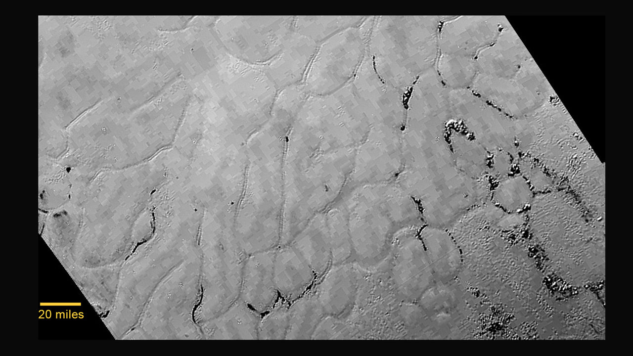
In the center left of Pluto’s vast heart-shaped feature – informally named “Tombaugh Regio” - lies a vast, craterless plain that appears to be no more than 100 million years old, and is possibly still being shaped by geologic processes. This frozen region is north of Pluto’s icy mountains and has been informally named Sputnik Planum (Sputnik Plain), after Earth’s first artificial satellite. The surface appears to be divided into irregularly-shaped segments that are ringed by narrow troughs. Features that appear to be groups of mounds and fields of small pits are also visible. This image was acquired by the Long Range Reconnaissance Imager (LORRI) on July 14 from a distance of 48,000 miles (77,000 kilometers). Features as small as one-half mile (1 kilometer) across are visible. The blocky appearance of some features is due to compression of the image.
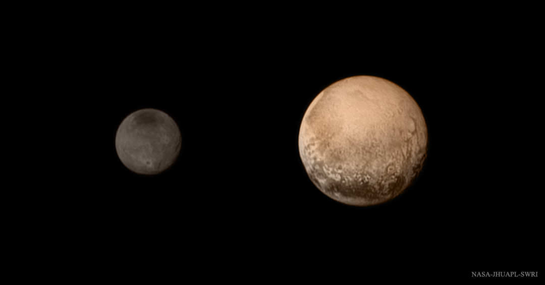
Credits: NASA/JHUAPL/SWRI
After New Horizons made its close flyby of Pluto in July of 2015, scientists were astounded at the incredible closeup views of Pluto’s surface. One of the most intriguing and mysterious features was a bright plain inside the prominent heart-shaped feature on Pluto, called “Tombaugh Regio” (Tombaugh Region) named after Clyde Tombaugh, who discovered Pluto in 1930.
The region is composed of a broken surface of irregularly-shaped segments that appear to be geologically young because no impact craters are part of the terrain.
NASA's New Horizons spacecraft captured this image of Sputnik Planitia — a glacial expanse rich in nitrogen, carbon monoxide and methane ices — that forms the left lobe of a heart-shaped feature on Pluto’s surface. SwRI scientists studied the dwarf planet’s nitrogen and carbon monoxide composition to develop a new theory for its formation. Credit: NASA/Johns Hopkins University Applied Physics Laboratory/Southwest Research Institute
In July of 2015, the New Horizons mission made history when it conducted the first flyby in history of Pluto. In the course of conducting its flyby, the probe gathered volumes of data about Pluto’s surface, composition, atmosphere and system of moons. It also provided breathtaking images of Pluto’s “heart”, its frozen plains, mountain chains, and it’s mysterious “bladed terrain”.
These strange features showed people for the first time how radically different the surface of Pluto is from Earth and the other planets of the inner Solar System. But strangely, they also showcased how this distant world is also quite similar to Earth. For instance, in a new study, a team of researchers working on the images from the New Horizons mission noticed “dunes” on the surface of Pluto that resemble sand dunes here on Earth.
The study, titled “Dunes on Pluto“, was recently published in the journal Science. The study was led by Matthew Telfer, a Lecturer in Physical Geography from the University of Plymouth, with significant contributions provided by Eric J. R. Parteli and Jani Radebaugh – geoscientists from the University of Cologne, and Brigham Young University, respectively.
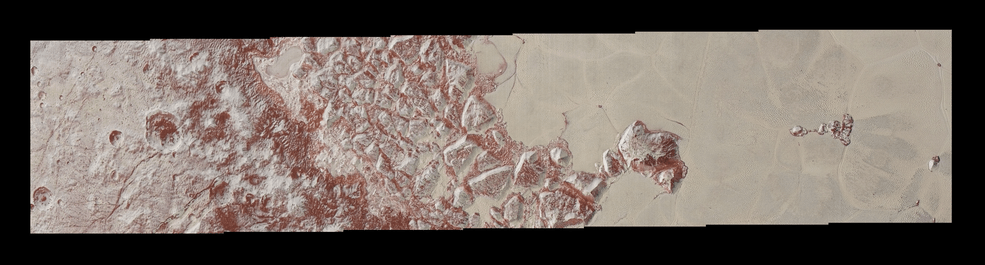
The fine smudges on Sputnik Planum have been identified as transverse dunes because of the way they run perpendicular to the dark “wind streaks”. Credit: NASA/JPL/New Horizons
On Earth, dunes are formed by wind-blown sand that create repeated ridges in the desert or along beaches. Similar patterns have been observed along river beds and alluvial plains, where water deposits sediment over time. In all cases, dune-like formations are the result of solid particles being transported by a moving medium (i.e. air or water). Beyond Earth, such patterns have been observed on Mars, Titan, and even on Comet 67P/Churyumov-Gerasimenko.
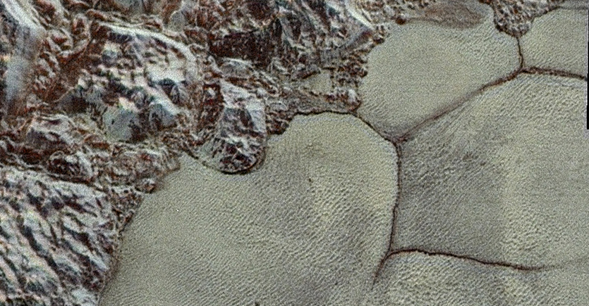
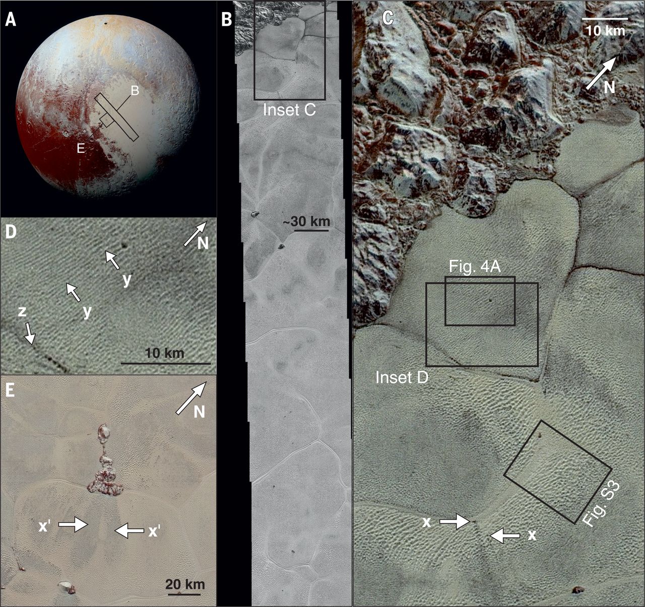
However, when consulting images from New Horizons probe, Telfer and his colleagues noted similar formations in the Sputnik Planitia region on Pluto. This region, which constitutes the western lobe of the heart-shaped Tombaugh Regio, is essentially a massive ice-covered basin. Already, researchers have noted that the surface appears to consist of irregular polygons bordered by troughs, which appear to be indications of convection cells.
As Dr. Telfer told Universe Today via email:
“We first saw some features looked kind of dune-like within the first few days, but as time passed, and new images came in, most of these seemed less and less convincing. But one area became more and more convincing with every pass. This is what we’re reporting on.”
Another interesting feature is the dark streams that are a few kilometers long and are all aligned in the same direction. But equally interesting were the features that Telfer and his team noticed, which looked like dunes that ran perpendicular to the wind streaks. This indicated that they were transverse dunes, the kinds that pile up due to prolonged wind activity in the desert.
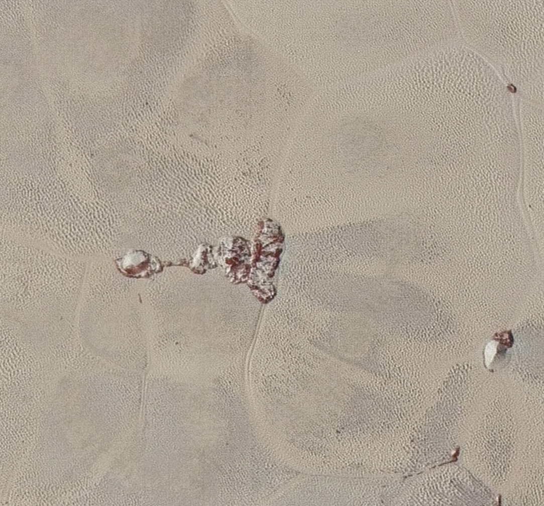
New Horizon images showing the patterns on Pluto’s surface that were hypothesized to be dunes. Credit: NASA/JPL/University of Arizona
To determine if this was a plausible hypothesis, the researchers constructed models that took into account what kind of particles would make up these dunes. They concluded that either methane or nitrogen ice would be able to form sand-sized grains that could be transported by typical winds. They then modeled the physics of Pluto’s winds, which would be strongest coming down the slopes of the mountains that border Sputnik Planum.
However, they also determined that Pluto’s winds would not be strong enough to push the particles around on their own. This is where sublimation played a key role, where surface ice goes from a solid phase directly to a gas when warmed by sunlight. This sublimation would provide the upward force necessary to lift the particles, at which point they would be caught by Pluto’s winds and blown around.
As Dr. Telfer explained, this conclusion was made possible thanks to the immense amount of support his team got, much of which came from the New Horizons Geology, Geophysics and Imaging Science Theme Team:
“Once we’d done the spatial analysis that made us really sure that these features made sense as dunes, we had the great opportunity to hook up with Eric Parteli at Cologne; he showed us through his modelling that the dunes should form, as long as the grains become airborne in the first place. The NASA New Horizons team really helped here, as they pointed out that mixed nitrogen/methane ices would preferentially fling methane ice grains upwards as the ices sublimated.”
Comparison of dune features on Pluto with those on Earth and Mars. Credit: NASA/JPL/University of Arizona
In addition to showing that Pluto, one of the most distant objects in the Solar System, has a few things in common with Earth, this study has also shown just how active Pluto’s surface is. “It shows us that not only is Pluto’s surface affecting its atmosphere, the converse is also true,” said Dr. Telfer. “We have a really dynamic world’s surface, so far out in the solar system.
On top of that, understanding how dunes can form under Pluto’s conditions will help scientists to interpret similar features found elsewhere in the Solar System. For example, NASA is planning on sending a mission to Titan in the coming decade to study its many interesting surface features, which include its dune formations. And many more missions are being sent to explore the Red Planet before a crewed mission takes place in the 2030s.
Knowing how such formations were created are key to understanding the dynamics of the planet, which will help answer some of the deeper questions about what is taking place on the surface.
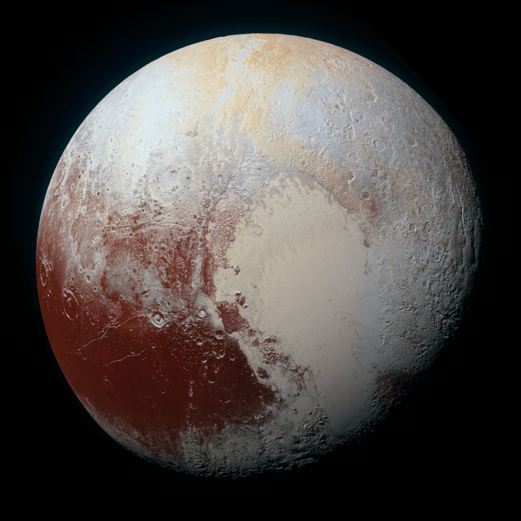
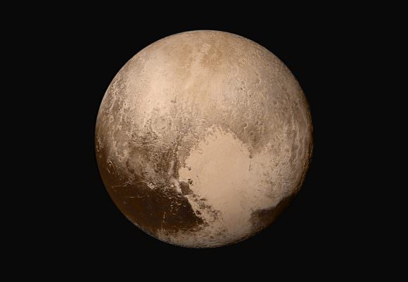
Pluto was re-classified as a dwarf planet based on our growing understanding of its nature. Will Schlaufman's new study help us more accurately classify gas giants and brown dwarfs? NASA's New Horizons spacecraft captured this high-resolution enhanced color view of Pluto on July 14, 2015. Credit: NASA/JHUAPL/SwRI
When Pluto was first discovered by Clybe Tombaugh in 1930, astronomers believed that they had found the ninth and outermost planet of the Solar System. In the decades that followed, what little we were able to learn about this distant world was the product of surveys conducted using Earth-based telescopes. Throughout this period, astronomers believed that Pluto was a dirty brown color.
In recent years, thanks to improved observations and the New Horizons mission, we have finally managed to obtain a clear picture of what Pluto looks like. In addition to information about its surface features, composition and tenuous atmosphere, much has been learned about Pluto’s appearance. Because of this, we now know that the one-time “ninth planet” of the Solar System is rich and varied in color.
Composition:
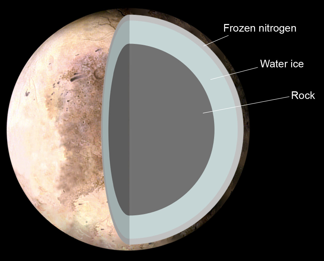
With a mean density of 1.87 g/cm3, Pluto’s composition is differentiated between an icy mantle and a rocky core. The surface is composed of more than 98% nitrogen ice, with traces of methane and carbon monoxide. Scientists also suspect that Pluto’s internal structure is differentiated, with the rocky material having settled into a dense core surrounded by a mantle of water ice.
The Theoretical structure of Pluto, consisting of 1. Frozen nitrogen 2. Water ice 3. Rock. Credit: NASA/Pat Rawlings
The diameter of the core is believed to be approximately 1700 km, which accounts for 70% of Pluto’s total diameter. Thanks to the decay of radioactive elements, it is possible that Pluto contains a subsurface ocean layer that is 100 to 180 km thick at the core–mantle boundary.
Pluto has a thin atmosphere consisting of nitrogen (N2), methane (CH4), and carbon monoxide (CO), which are in equilibrium with their ices on Pluto’s surface. However, the planet is so cold that during part of its orbit, the atmosphere congeals and falls to the surface. The average surface temperature is 44 K (-229 °C), ranging from 33 K (-240 °C) at aphelion to 55 K (-218 °C) at perihelion.
Appearance:
Pluto’s surface is very varied, with large differences in both brightness and color. Pluto’s surface also shows signs of heavy cratering, with ones on the dayside measuring 260 km (162 mi) in diameter. Tectonic features including scarps and troughs has also been seen in some areas, some as long as 600 km (370 miles).
Mountains have also been seen that are between 2 to 3 kilometers (6500 – 9800 ft) in elevation above their surroundings. Like much of the surface, these features are believed to be composed primarily of frozen nitrogen, carbon monoxide, and methane, which are believed to sit atop a “bedrock” of frozen water ice.
Color mosaic map of Pluto’s surface, created from the New Horizons many photographs. Credit: NASA/JHUAPL/SwRI
The surface also has many dark, reddish patches due to the presence of tholins, which are created by charged particles from the Sun interacting with mixtures of methane and nitrogen. Pluto’s visual apparent magnitude averages 15.1, brightening to 13.65 at perihelion. In other words, the planet has a range of colors, including pale sections of off-white and light blue, to streaks of yellow and subtle orange, to large patches of deep red.
Overall, its appearance could be described as “ruddy”, given that the combination can lend it a somewhat brown and earthy appearance from a distance. In fact, prior to the New Horizon‘s mission, which provided the first high-resolution, close-up images of the planet, this is precisely what astronomers believed Pluto looked like.
Major Surface Features:
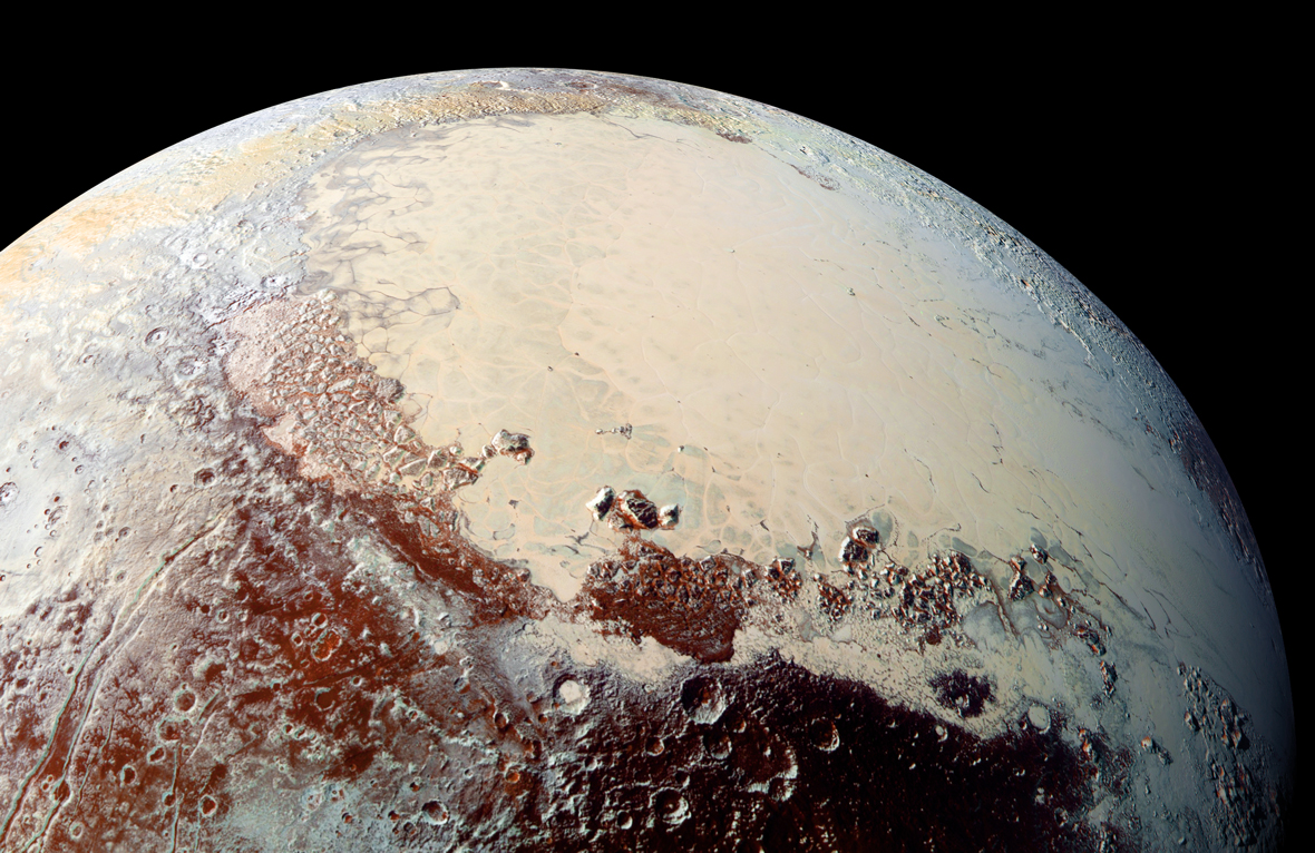
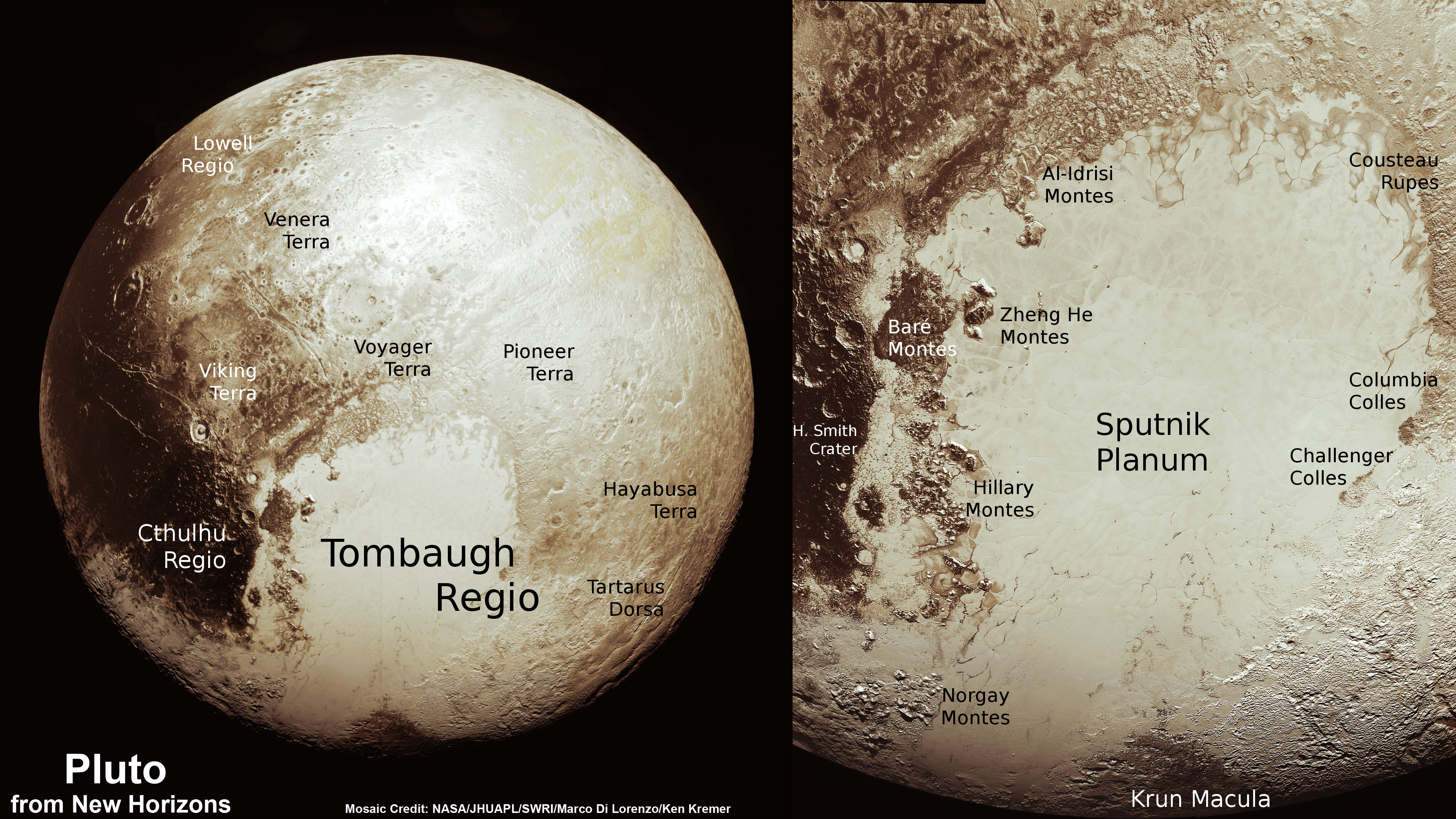
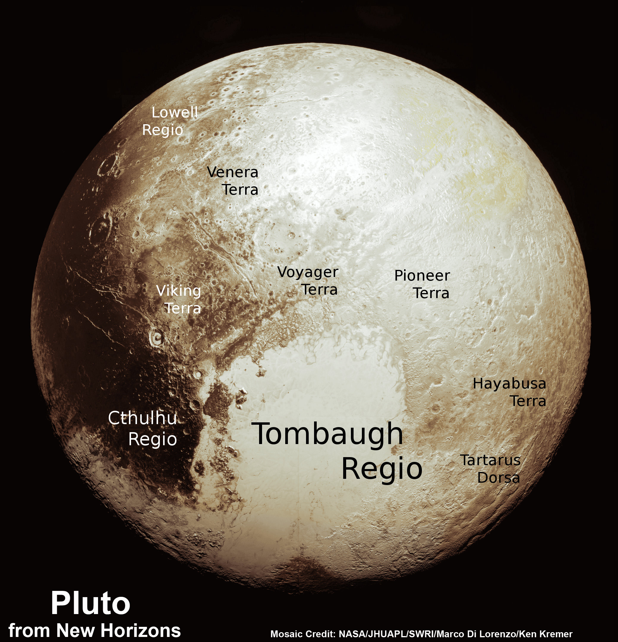
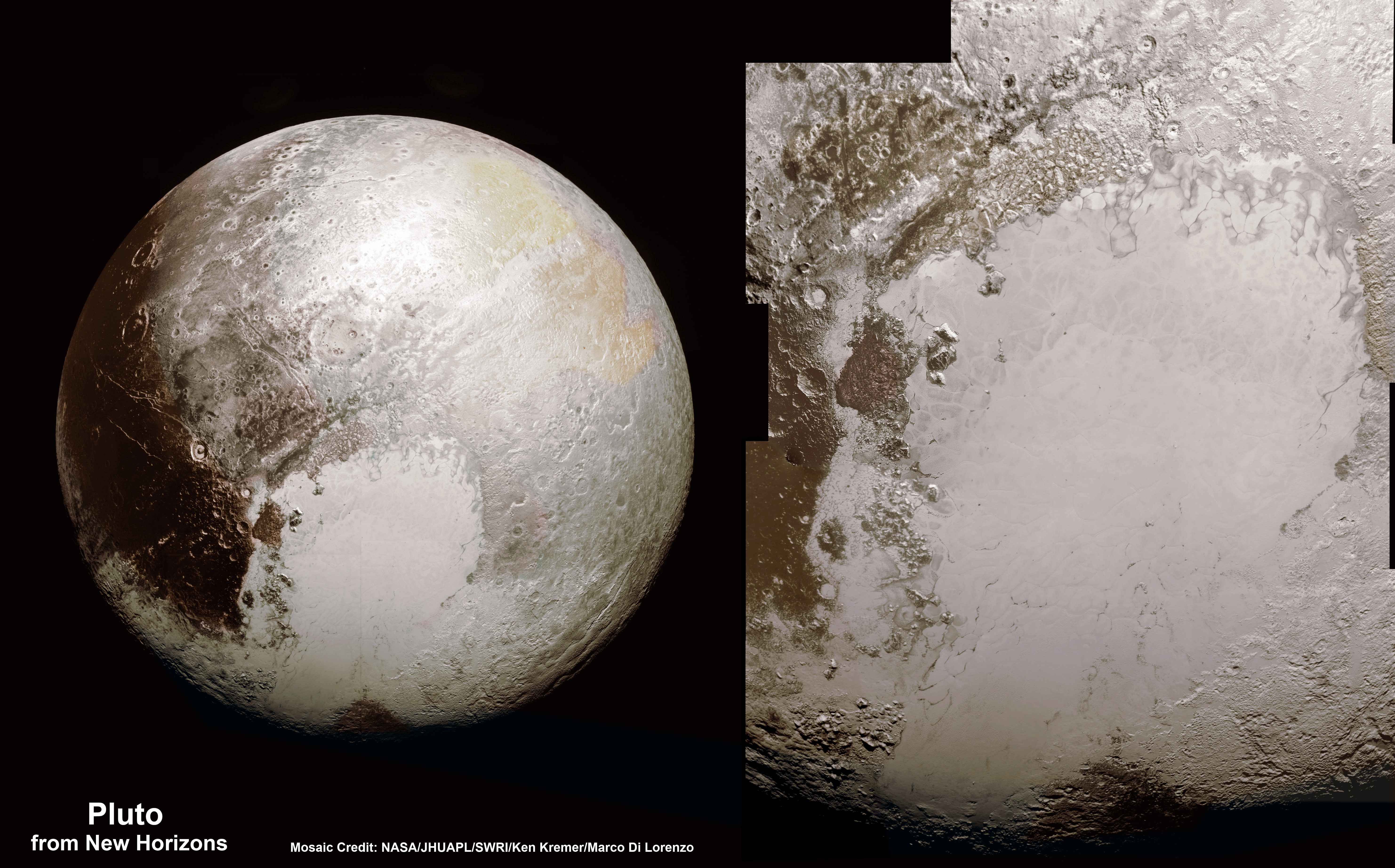
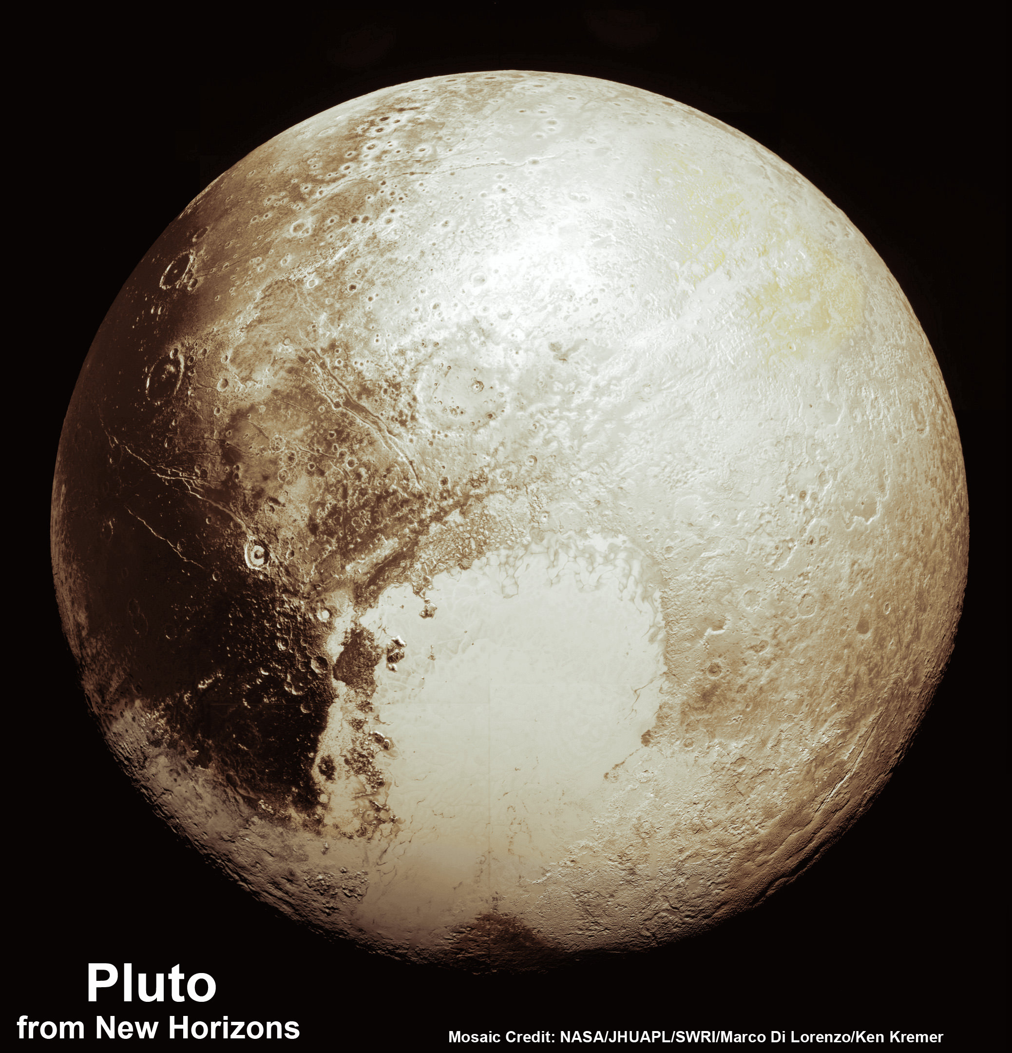
Several different regions (“regio”) have been characterized based on the notable features they possess. Perhaps the best known is the large, pale area nicknamed the “Heart” – aka. Tombaugh Regio (named after Pluto’s founder). This large bright area is located on the side of Pluto that lies opposite the side that faces Charon, and is named because of its distinctive shape.
Tombaugh Regio is about 1,590 km (990 mi) across and contains 3,400 m (11,000 ft) mountains made of water ice along its southwestern edge. The lack of craters suggests that its surface is relatively young (about 100 million years old) and hints at Pluto being geologically active. The Heart can be subdivided into two lobes, which are distinct geological features that are both bright in appearance.
This new global mosaic view of Pluto was created from the latest high-resolution images to be downlinked from NASA’s New Horizons spacecraft and released on Sept. 11, 2015. Credits: NASA/Johns Hopkins APL/SwRI/Marco Di Lorenzo/Ken Kremer
The western lobe, Sputnik Planitia, is vast plain of nitrogen and carbon monoxide ices measuring 1000 km in width. It is divided into polygonal sections that are believed to be convection cells, which carry blocks of water ice and sublimation pits along towards the edge of the plain. This region is especially young (less than 10 million years old), which is indicated by its lack of cratering.
Then there is the large, dark area on the trailing hemisphere known as Cthulhu Regio (aka.the “Whale”). Named for its distinctive shape, this elongated, dark region along the equator is the largest dark feature on Pluto – measuring 2,990 km (1,860 mi) in length. The dark color is believed to be the result methane and nitrogen in the atmosphere interacting with ultraviolet light and cosmic rays, creating the dark particles (“tholins”) common to Pluto.
And then there are the “Brass Knuckles”, a series of equatorial dark areas on the leading hemisphere. These features average around 480 km (300 mi) in diameter, and are located along the equator between the Heart and the tail of the Whale.
New Horizons Mission:
The NH mission launched from Cape Canaveral Air Force Station in Florida on January 19th, 2006. After swinging by Jupiter for a gravity boost and to conduct some scientific studies in February of 2007, it reached Pluto in the summer of 2015. Once there, it conducted a six month-long reconnaissance flyby of Pluto and its system of moons, culminating with a closest approach that occurred on July 14th, 2015.
A portrait from the final approach of the New Horizons spacecraft to the Pluto system on July 11th, 2015. Pluto and Charon display striking color and brightness contrast in this composite image. Credit: NASA-JHUAPL-SWRI.
The first images of Pluto acquired by NH were taken on September 21st to 24th, 2006, during a test of the Long Range Reconnaissance Imager (LORRI). At the time, the probe was still at a distance of approximately 4.2 billion km (2.6 billion mi) or 28 AU, and the photos were released on November 28th, 2006. Between July 1st and 3rd, the first images were taken that were able to resolved Pluto and its largest moon, Charon, as separate objects.
Between July 19th–24th, 2014, the probe snapped 12 images of Charon revolving around Pluto, covering almost one full rotation at distances ranging from 429 to 422 million kilometers (267,000,000 to 262,000,000 mi). After a brief hibernation during its final approach, New Horizons “woke up” on Dec. 7th, 2014. Distant-encounter operations began on January 4th, 2015, and NH began taking images of Pluto as it grew closer.
During its closest approach (July 14th, 2015, at at 11:50 UTC), the NH probe passed within 12,500 km (7,800 mi) of Pluto. About 3 days before making its closest approach, long-range imaging of Pluto and Charon took place that were 40 km (25 mi) in resolution, which allowed for all sides of both bodies to be mapped out.
Close-range imaging also took place twice a day during this time to search for any indication of surface changes. The NH probe also analyzed Pluto’s atmosphere using its suite of scientific instruments. This included it’s ultraviolet imaging spectrometer (aka. Alice) and the Radio Science EXperiment (REX), which analyzed the composition and structure of Pluto’s atmosphere.
Haze with multiple layers in the atmosphere of Pluto. Part of the plain Sputnik Planitia with nearby mountains is seen below. Photo by New Horizons, taken 15 min after the closest approach to Pluto. Credit: NASA/JHUAPL/SwRI
It’s Solar Wind Around Pluto (SWAP) and Pluto Energetic Particle Spectrometer Science Investigation (PEPSSI) examined the interaction of Pluto’s high atmosphere with solar wind. Pluto’s diameter was also resolved by measuring the disappearance and reappearance of the radio occultation signal as the probe flew by behind Pluto. And the gravitational tug on the probe were used to determine Pluto’s mass and mass distribution.
All of this information has helped astronomers to make the first detailed maps of Pluto, and led to numerous discoveries about Pluto’s structure, composition, and the kinds of forces that actively shape its surface. The mission also led to the first true images of what Pluto looks like up close, revealing its true colors, it’s famous “Heart” region, and the many other now-famous features.
This mosaic of Pluto's surface was created from images taken by the New Horizons probe just 23 minutes before its closest approach. Credit: NASA/JHUAPL/SwRI
The New Horizons mission, which its conducted its historic flyby on July 14th, 2015, has yielded a wealth of scientific data about Pluto. This has included discoveries about Pluto’s size, its mountainous regions, its floating ice hills, and (more recently) how the dwarf planet interacts with solar wind – a discovery which showed that Pluto is actually more planet-like than previously thought.
But beyond revelations about the planet’s size, geography and surface features, it has also provided the most breathtaking, clear, and inspiring images of Pluto and its moons to date. And with this latest release of images taken by the New Horizon‘s Long Range Reconnaissance Imager (LORRI), people here on Earth are being treated to be the best close-up of Pluto yet.
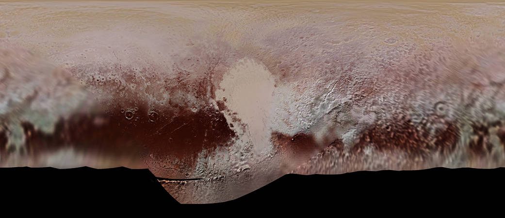
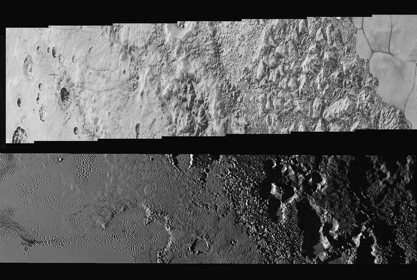
These images, which were taken while the New Horizon’s probe was still 15,850 km (9,850 mi) away from Pluto (just 23 minutes before it made its closest approach), extend across the hemisphere that the probe was facing as it flew past. It shows features ranging from the cratered northern uplands and the mountainous regions in Voyager Terra before slicing through the flatlands of “Pluto’s Heart” – aka. Tombaugh Regio – and ending up in another stretch of rugged highlands.
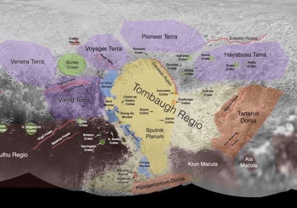
Informal names given to Pluto’s surface features. Credit: earthsky.org
The width of the strip varies as the images pass from north to south, from more than 90 km (55 mi) across at the northern end to about 75 km (45 mi) at its southern point. The perspective also changes, with the view appearing virtually horizontal at the northern end and then shifting to an almost top-down view onto the surface by the end.
The crystal clear photographs that make up the mosaic – which have a resolution of about 80 meters (260 feet) per pixel – offer the most detailed view of Pluto’s surface ever. With this kind of clarity, NASA scientists are able to discern features that were never before visible, and learn things about the kinds of geological processes which formed them.
This includes the chaotic nature of the mountains in the northern hemisphere, and the varied nature of the icy nitrogen plains across Tombaugh Regio – which go from being cellular, to non-cellular, to a cross-bedding pattern. These features are a further indication that Pluto’s surface is the product of a combination of geological forces, such as cryovolcanism, sublimation, geological activity, convection between water and nitrogen ice, and interaction between the surface and atmosphere.
Images snapped by New Horizons’ Long Range Reconnaissance Imager (LORRI) while the probe was still on approach to Pluto were combined with color data from the Ralph instrument to create this global view of Pluto. Credits: NASA/JHUAPL/SwRI
Alan Stern, the principal investigator of the New Horizons mission and the Associate Vice President of Research and Development at the Southwest Research Institute, was especially impressed with this latest find. As he told Universe Today via email:
“This new high resolution image mosaic is the complete highest resolution strip of images New Horizons obtained, and its both eye candy gorgeous and scientifically rich. Think about it— one flyby and we have this mosaic, plus so much more; no dataset like this existed on Mars until we’d flown half a dozen missions there!”
The most distant flyby in the history of space exploration, and yet we’ve obtained more from this one mission than multiple flybys were able to provide from one of Earth’s closest neighbors. Fascinating! And what’s more, new information is expected to be coming from the New Horizons probe until this coming October. To top it off, our scientists are still not finished analyzing all the information the mission collected during its flyby.
The full-resolution image can be viewed here, and be sure to enjoy this NASA video of the mosaic:
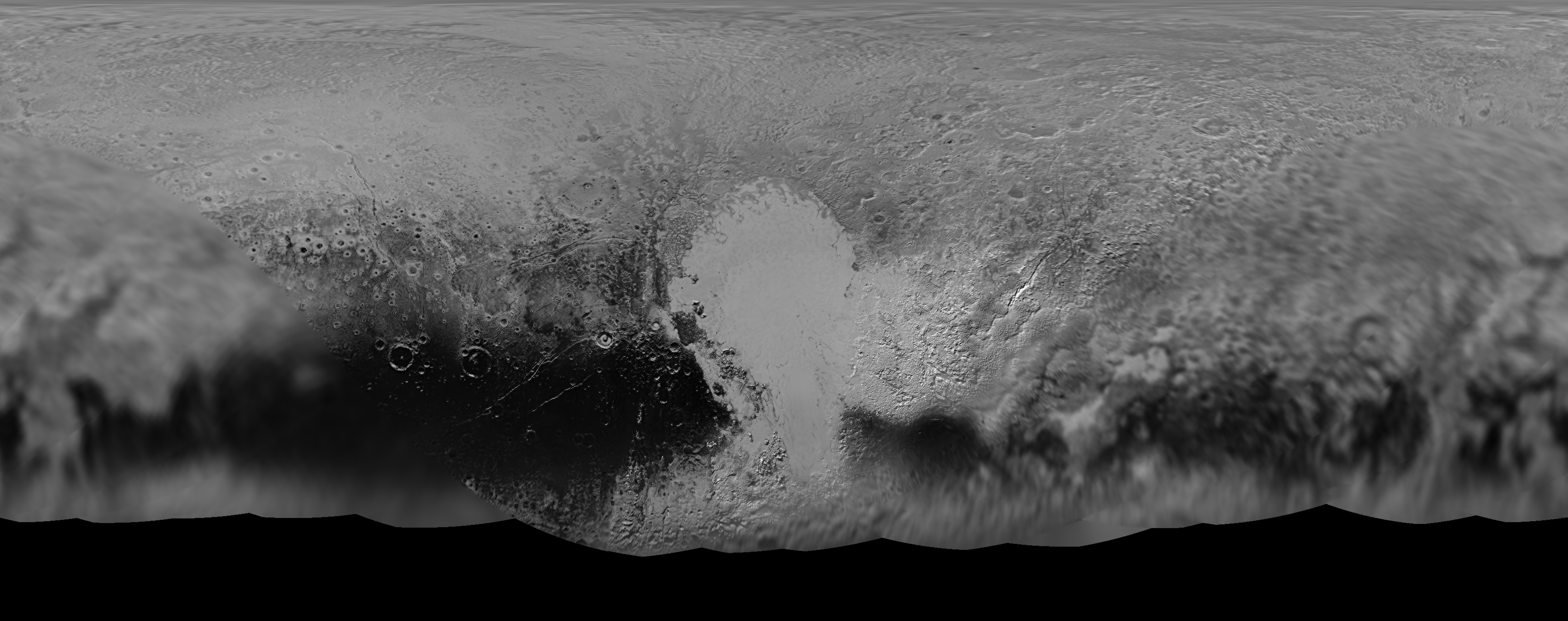
NASA’s New Horizons mission science team has produced this updated panchromatic (black-and-white) global map of Pluto. Credits: NASA/JHUAPL/SWRI
NASA’s New Horizons mission science team has produced this updated panchromatic (black-and-white) global map of Pluto. Credits: NASA/JHUAPL/SWRI
The science team leading NASA’s New Horizons mission that unveiled the true nature of Pluto’s long hidden looks during the history making maiden close encounter last July, have published a fresh global map that offers the sharpest and most spectacular glimpse yet of the mysterious, icy world.
The newly updated global Pluto map is comprised of all the highest resolution images transmitted back to Earth thus far and provides the best perspective to date.
Click on the lead image above to enjoy Pluto revealed at its finest thus far. Click on this link to view the highest resolution version.
Prior to the our first ever flyby of the Pluto planetary system barely 8 months ago, the planet was nothing more than a fuzzy blob with very little in the way of identifiable surface features – even in the most powerful telescopic views lovingly obtained from the Hubble Space Telescope (HST).
Dead center in the new map is the mesmerizing heart shaped region informally known as Tombaugh Regio, unveiled in all its glory and dominating the diminutive world.
The panchromatic (black-and-white) global map of Pluto published by the team includes the latest images received as of less than one week ago on April 25.
The images were captured by New Horizons’ high resolution Long Range Reconnaissance Imager (LORRI).
The science team is working on assembling an updated color map.
During its closest approach at approximately 7:49 a.m. EDT (11:49 UTC) on July 14, 2015, the New Horizons spacecraft swoop to within about 12,500 kilometers (nearly 7,750 miles) of Pluto’s surface and about 17,900 miles (28,800 kilometers) from Charon, the largest moon.
The map includes all resolved images of Pluto’s surface acquired in the final week of the approach period ahead of the flyby starting on July 7, and continuing through to the day of closest approach on July 14, 2015 – and transmitted back so far.
The pixel resolutions are easily seen to vary widely across the map as you scan the global map from left to right – depending on which Plutonian hemisphere was closest to the spacecraft during the period of close flyby.
They range from the highest resolution of 770 feet (235 meters), at center, to 18 miles (30 kilometers) at the far left and right edges.
The Charon-facing hemisphere (left and right edges of the map) had a pixel resolution of 18 miles (30 kilometers).
“This non-encounter hemisphere was seen from much greater range and is, therefore, in far less detail,” noted the team.
However the hemisphere facing New Horizons during the spacecraft’s closest approach on July 14, 2015 (map center) had a far higher pixel resolution reaching to 770 feet (235 meters).
Coincidentally and fortuitously the spectacularly diverse terrain of Tombaugh Regio and the Sputnik Planum area of the hearts left ventricle with ice flows and volcanoes, mountains and river channels was in the region facing the camera and sports the highest resolution imagery.
See below a newly released shaded relief map of Sputnik Planum.
This new shaded relief view of the region surrounding the left side of Pluto’s heart-shaped feature – informally named Sputnik Planum – shows that the vast expanse of the icy surface is on average 2 miles (3 kilometers) lower than the surrounding terrain. Angular blocks of water ice are “floating” in the bright deposits of softer, denser solid nitrogen. Credits: NASA/JHUAPL/SwRI
“Sputnik Planum – shows that the vast expanse of the icy surface is on average 2 miles (3 kilometers) lower than the surrounding terrain. Angular blocks of water ice along the western edge of Sputnik Planum can be seen “floating” in the bright deposits of softer, denser solid nitrogen,” according to the team.
Even more stunning images and groundbreaking data will continue streaming back from New Horizons until early fall, across over 3 billion miles of interplanetary space.
Thus the global map of Pluto will be periodically updated.
Its taking over a year to receive the full complement of some 50 gigabits of data due to the limited bandwidth available from the transmitter on the piano-shaped probe as it hurtled past Pluto, its largest moon Charon and four smaller moons.
Pluto is the last planet in our solar system to be visited in the initial reconnaissance of planets by spacecraft from Earth since the dawn of the Space Age.
This new global mosaic view of Pluto was created from the latest high-resolution images to be downlinked from NASA’s New Horizons spacecraft and released on Sept. 11, 2015. The images were taken as New Horizons flew past Pluto on July 14, 2015, from a distance of 50,000 miles (80,000 kilometers). This new mosaic was stitched from over two dozen raw images captured by the LORRI imager and colorized. Annotated with informal place names. Credits: NASA/Johns Hopkins University Applied Physics Laboratory/Southwest Research Institute/Marco Di Lorenzo/Ken Kremer/kenkremer.com
New Horizons remains on target to fly by a second Kuiper Belt Object (KBO) on Jan. 1, 2019 – tentatively named PT1, for Potential Target 1. It is much smaller than Pluto and was recently selected based on images taken by NASA’s Hubble Space Telescope.
Stay tuned here for Ken’s continuing Earth and planetary science and human spaceflight news.
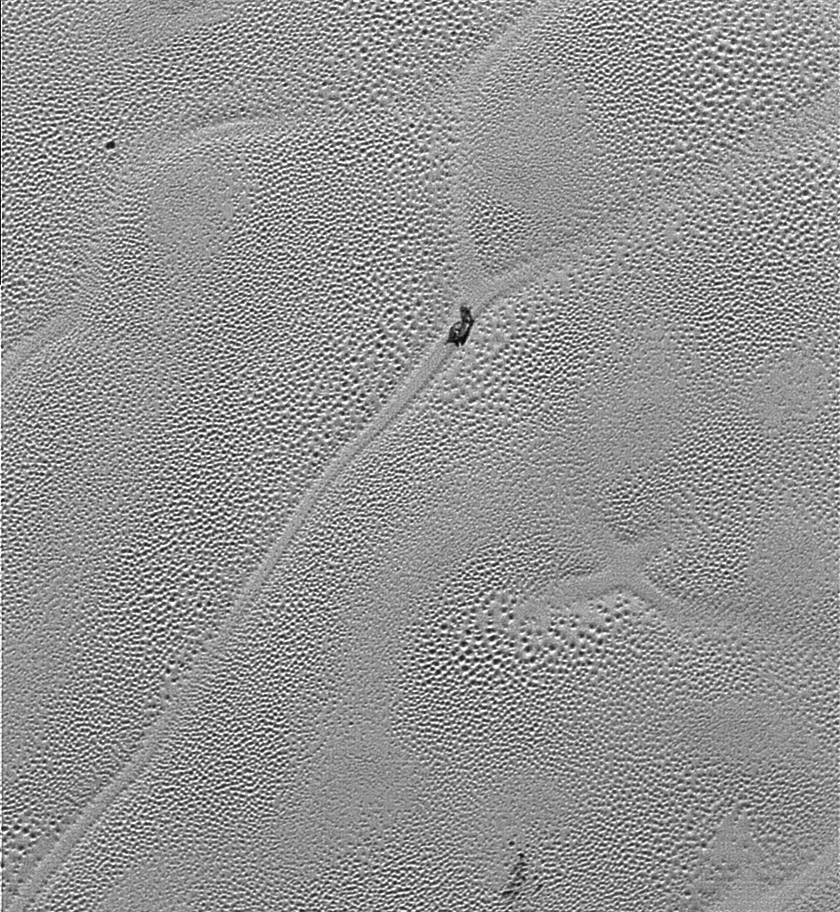
“X” marks the spot in this image transmitted to Earth on Dec. 24, 2015 from the Long Range Reconnaissance Imager (LORRI) from NASA’s New Horizons’ showing the highest-resolution swath of Pluto at the center of Sputnik Planum, the informally named plain that forms the left side of Pluto’s “heart.” The pattern of polygonal cells stems from the slow thermal convection of the nitrogen-dominated ices. Also visible is a a dirty block of water ice “floating” in denser solid nitrogen. Credits: NASA/JHUAPL/SwRI
“X” marks the spot that’s illustrative of “convective churning” resulting from subsurface planetary heating, as seen in a fascinating new super high resolution image received from NASA’s New Horizons spacecraft on Christmas Eve, Dec. 24, 2015. Its situated at the very center of the left ventricle of Pluto’s huge “heart” – an icy flow plain that’s informally named “Sputnik Planum.”
The “X” feature – see image above – is located in an area of intersecting cells, shaped like polygons, on the plains of “Sputnik Planum” which are mostly comprised of frozen nitrogen ices.
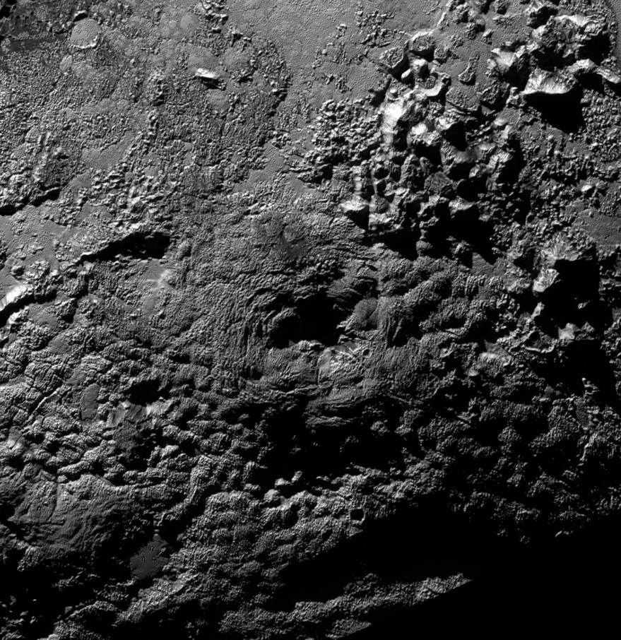
Ice Volcanoes on Pluto? The informally named feature Wright Mons, located south of Sputnik Planum on Pluto, is an unusual feature that’s about 100 miles (160 kilometers) wide and 13,000 feet (4 kilometers) high. It displays a summit depression (visible in the center of the image) that's approximately 35 miles (56 kilometers) across, with a distinctive hummocky texture on its sides. The rim of the summit depression also shows concentric fracturing. New Horizons scientists believe that this mountain and another, Piccard Mons, could have been formed by the 'cryovolcanic' eruption of ices from beneath Pluto's surface. Credit: NASA/Johns Hopkins University Applied Physics Laboratory/Southwest Research Institute
Ice Volcanoes on Pluto?
The informally named feature Wright Mons, located south of Sputnik Planum on Pluto, is an unusual feature that’s about 100 miles (160 kilometers) wide and 13,000 feet (4 kilometers) high. It displays a summit depression (visible in the center of the image) that’s approximately 35 miles (56 kilometers) across, with a distinctive hummocky texture on its sides. The rim of the summit depression also shows concentric fracturing. New Horizons scientists believe that this mountain and another, Piccard Mons, could have been formed by the ‘cryovolcanic’ eruption of ices from beneath Pluto’s surface. Credit: NASA/Johns Hopkins University Applied Physics Laboratory/Southwest Research Institute[/caption]
The possible discovery of a pair of recently erupting ice volcanoes on Pluto are among the unexpected “astounding” findings just unveiled by perplexed scientists with NASA’s New Horizons spacecraft, barely four months after the historic first flyby of the last unexplored planet in our solar system.
“Nothing like this has been seen in the deep outer solar system,” said Jeffrey Moore, New Horizons Geology, Geophysics and Imaging team leader from NASA Ames Research Center, Moffett Field, California, as the results so far were announced at the 47th Annual Meeting of the Division for Planetary Sciences (DPS) of the American Astronomical Society (AAS) this week in National Harbor, Maryland.
“The Pluto system is baffling us,” said mission Principal Investigator Alan Stern of the Southwest Research Institute, Boulder, Colorado, at a news media briefing on Nov. 9.
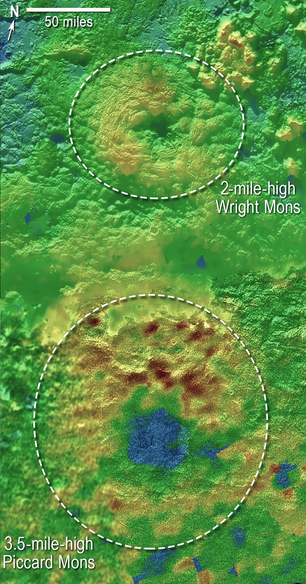
Two large mountainous features tens of miles across and several miles high, have been potentially identified by the team as volcanoes.
Scientists using New Horizons images of Pluto’s surface to make 3-D topographic maps have discovered that two of Pluto’s mountains, informally named Wright Mons and Piccard Mons, could possibly be ice volcanoes. The color is shown to depict changes in elevation, with blue indicating lower terrain and brown showing higher elevation; green terrains are at intermediate heights. Credit: NASA/Johns Hopkins University Applied Physics Laboratory/Southwest Research Institute
They were found in terrain located south of Sputnik Planum – a vast area of smooth icy plains located within Pluto’s huge heart shaped region informally known as Tombaugh Regio. It may have formed very recently resulting from geologic activity within the past 10 million years.
The possible ice volcanoes, or cryovolcanoes, were found at two of Pluto’s most distinctive mountains and identified from images taken by New Horizons as it became Earth’s first emissary to hurtle past the small planet on July 14, 2015.
“All of our flyby plans succeeded,” Stern stated at the briefing.
“All of the data sets are spectacular.
Scientists created 3-D topographic maps from the probes images and discovered the possible ice volcanoes – informally named Wright Mons and Piccard Mons.
Wright Mons, pictured above, is about 100 miles (160 kilometers) wide and 13,000 feet (4 kilometers) high.
Both mountains appear to show summit depressions “with a large hole” visible in the center, similar to volcanoes on Earth. Scientists speculate “they may have formed by the ‘cryovolcanic’ eruption of ices from beneath Pluto’s surface.”
The erupting Plutonian ices might be composed of a melted slurry of water ice, nitrogen, ammonia and methane.
The depression inside Wright Mons is approximately 35 miles (56 kilometers) across and exhibits a “distinctive hummocky texture on its sides. The rim of the summit depression also shows concentric fracturing.”
“These are big mountains with a large hole in their summit, and on Earth that generally means one thing—a volcano,” said Oliver White, New Horizons postdoctoral researcher with NASA Ames, in a statement.
The team is quick to caution that the “interpretation of these features as volcanoes is tentative” and requires much more analysis.
“If they are volcanic, then the summit depression would likely have formed via collapse as material is erupted from underneath. The strange hummocky texture of the mountain flanks may represent volcanic flows of some sort that have travelled down from the summit region and onto the plains beyond, but why they are hummocky, and what they are made of, we don’t yet know.”
This new global mosaic view of Pluto was created from the latest high-resolution images to be downlinked from NASA’s New Horizons spacecraft and released on Sept. 11, 2015. The images were taken as New Horizons flew past Pluto on July 14, 2015, from a distance of 50,000 miles (80,000 kilometers). This new mosaic was stitched from over two dozen raw images captured by the LORRI imager and colorized. Right side inset from New Horizons team focuses on Tombaugh Regio heart shaped feature. Annotated with informal place names. Credits: NASA/Johns Hopkins University Applied Physics Laboratory/Southwest Research Institute/Marco Di Lorenzo/Ken Kremer/kenkremer.com
More than 50 papers about the Pluto system are being presented at the AAS meeting this week.
So far New Horizon has transmitted back only about 20 percent of the data gathered, according to mission Principal Investigator Alan Stern.
“It’s hard to imagine how rapidly our view of Pluto and its moons are evolving as new data stream in each week. As the discoveries pour in from those data, Pluto is becoming a star of the solar system,” said Stern.
“Moreover, I’d wager that for most planetary scientists, any one or two of our latest major findings on one world would be considered astounding. To have them all is simply incredible.”
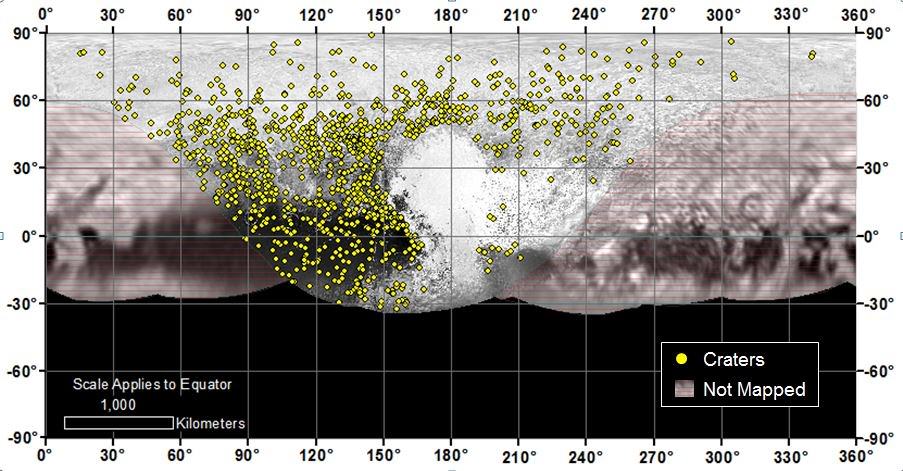
Locations of more than 1,000 craters mapped on Pluto by NASA’s New Horizons mission indicate a wide range of surface ages, which likely means that Pluto has been geologically active throughout its history. Credit: NASA/Johns Hopkins University Applied Physics Laboratory/Southwest Research Institute
The piano shaped probe gathered about 50 gigabits of data as it hurtled past Pluto, its largest moon Charon and four smaller moons.
Stern says it will take about a year for all the data to get back. Thus bountiful new discoveries are on tap for a long time to come.
With 20 percent of the data now returned and more streaming back every day, the team is excited to debate what is all means.
“This is when the debates begin,” said Curt Niebur, New Horizons program scientist at NASA Headquarters, at the missions Nov 9 media briefing. “This is when the heated discussions begin. This is when the entire science community starts staying up throughout the night.”
Stay tuned here for Ken’s continuing Earth and planetary science and human spaceflight news.
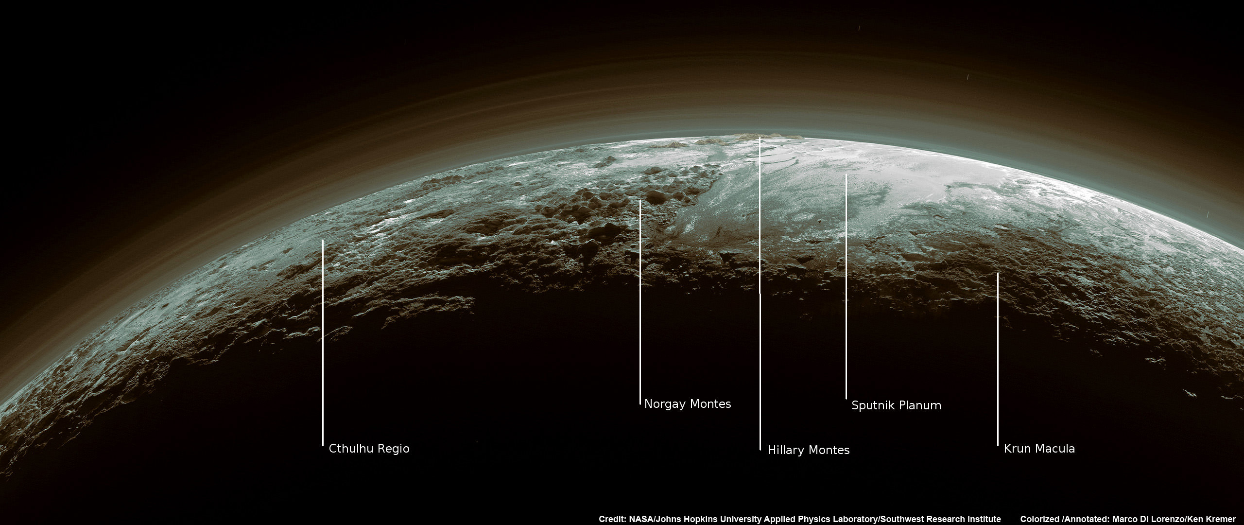
Just 15 minutes after its closest approach to Pluto on July 14, 2015, NASA’s New Horizons spacecraft looked back toward the sun and captured this near-sunset view of the rugged, icy mountains and flat ice plains extending to Pluto’s horizon – shown in this colorized rendition. The smooth expanse of the informally named icy plain Sputnik Planum (right) is flanked to the west (left) by rugged mountains up to 11,000 feet (3,500 meters) high, including the informally named Norgay Montes in the foreground and Hillary Montes on the skyline. To the right, east of Sputnik, rougher terrain is cut by apparent glaciers. The backlighting highlights more than a dozen layers of haze in Pluto’s tenuous but distended atmosphere. The image was taken from a distance of 11,000 miles (18,000 kilometers) to Pluto; the scene is 780 miles (1,250 kilometers) wide. Credit: NASA/Johns Hopkins University Applied Physics Laboratory/Southwest Research Institute. Colorized/Annotated: Marco Di Lorenzo/Ken Kremer/kenkremer.com
Pluto’s Blue Sky: Pluto’s haze layer shows its blue color in this picture taken by the New Horizons Ralph/Multispectral Visible Imaging Camera (MVIC). The high-altitude haze is thought to be similar in nature to that seen at Saturn’s moon Titan. The source of both hazes likely involves sunlight-initiated chemical reactions of nitrogen and methane, leading to relatively small, soot-like particles (called tholins) that grow as they settle toward the surface. Credits: NASA/JHUAPL/SwRI
With each passing day, significant discoveries about Pluto continue piling up higher and higher as more and more data gathered and stored from this past summer’s historic flyby by NASA’s New Horizons reaches ground stations back here on Earth.
“Blue skies–Pluto is awesome!” says Alan Stern, New Horizons principal investigator from Southwest Research Institute (SwRI), Boulder, Colorado.
The bluish tint to Pluto’s skies were unexpectedly discovered after researchers examined the first color images of the high altitude atmospheric hazes returned by New Horizons last week that were taken by the probes Ralph/Multispectral Visible Imaging Camera (MVIC).
“Who would have expected a blue sky in the Kuiper Belt?” Stern said in a NASA statement.
During New Horizons flyby on July 14, 2015, it discovered that Pluto is the biggest object in the outer solar system and thus the ‘King of the Kuiper Belt.”
The Kuiper Belt comprises the third and outermost region of worlds in our solar system.
“It’s gorgeous!” exclaims Stern.
Moreover, the source of Pluto’s blue haze is different from Earth’s and more related to Titan, Saturn’s largest moon – currently being explored by NASA’s Cassini mission orbiting Saturn since 2004.
On Earth, the blue sky is caused by light scattering off tiny particles of nitrogen molecules. Whereas on Titan its related to soot-like particles called tholins.
Tholins are generated by a series of very complex sunlight-initiated chemical reactions between nitrogen and methane (CH4) high in the atmosphere. This eventually produces relatively small, soot-like particles of complex hydrocarbons.
“That striking blue tint tells us about the size and composition of the haze particles,” said New Horizons science team researcher Carly Howett, of SwRI, in a statement.
“A blue sky often results from scattering of sunlight by very small particles. On Earth, those particles are very tiny nitrogen molecules. On Pluto they appear to be larger — but still relatively small — soot-like particles we call tholins.”
As the tholins rain down on Pluto, they add to the widespread red surface coloring.
The Ralph instrument was also key in another discovery announced by New Horizons researchers.
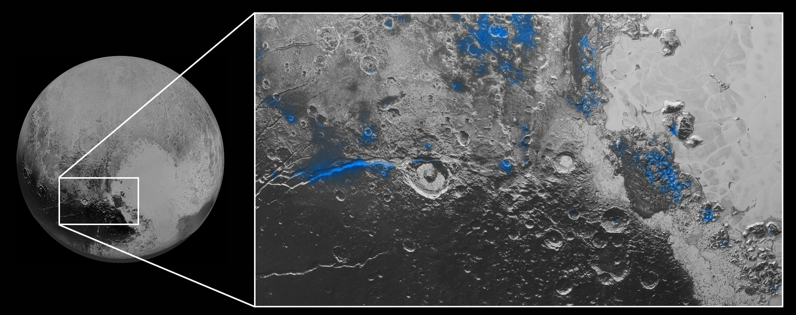
Numerous small, exposed regions of water ice on Pluto’s surface were discovered by combining measurements from the Ralph MVIC spectral composition mapper and infrared spectroscopy from the Linear Etalon Imaging Spectral Array (LEISA) instrument.
The strongest signatures of water ice were found in the Virgil Fossa and Viking Terra regions berby the western edge of Pluto’s huge heart-shaped Tombaugh Regio feature – see image below.
Water Ice on Pluto: Regions with exposed water ice are highlighted in blue in this composite image from New Horizons’ Ralph instrument, combining visible imagery from the Multispectral Visible Imaging Camera (MVIC) with infrared spectroscopy from the Linear Etalon Imaging Spectral Array (LEISA). The strongest signatures of water ice occur along Virgil Fossa, just west of Elliot crater on the left side of the inset image, and also in Viking Terra near the top of the frame. A major outcrop also occurs in Baré Montes towards the right of the image, along with numerous much smaller outcrops, mostly associated with impact craters and valleys between mountains. The scene is approximately 280 miles (450 kilometers) across. Note that all surface feature names are informal. Credits: NASA/JHUAPL/SwRI
Water ice is only found in certain zones of Pluto for reasons yet to be understood. There may also be a relationship to the tholins, that likewise is yet to be gleaned.
“I’m surprised that this water ice is so red,” says Silvia Protopapa, a science team member from the University of Maryland, College Park. “We don’t yet understand the relationship between water ice and the reddish tholin colorants on Pluto’s surface.”
This new global mosaic view of Pluto was created from the latest high-resolution images to be downlinked from NASA’s New Horizons spacecraft and released on Sept. 11, 2015. The images were taken as New Horizons flew past Pluto on July 14, 2015, from a distance of 50,000 miles (80,000 kilometers). This new mosaic was stitched from over two dozen raw images captured by the LORRI imager and colorized. Annotated with informal place names. Credits: NASA/Johns Hopkins University Applied Physics Laboratory/Southwest Research Institute/Marco Di Lorenzo/Ken Kremer/kenkremer.com
As of today, New Horizons remains healthy and is over 3.1 billion miles (5 billion kilometers) from Earth.
The team hopes to fire up the thrusters later this fall to propel the spacecraft toward a second Kuiper Belt Object (KBO) in 2019 tentativley named PT1, for Potential Target 1. It is much smaller than Pluto and was recently selected based on images taken by NASA’s Hubble Space Telescope.
Stay tuned here for Ken’s continuing Earth and planetary science and human spaceflight news.
This color image of Pluto taken by NASA’s New Horizons spacecraft shows rounded and bizarrely textured mountains, informally named the Tartarus Dorsa, rise up along Pluto’s terminator and show intricate but puzzling patterns of blue-gray ridges and reddish material in between. This view, roughly 330 miles (530 kilometers) across, combines blue, red and infrared images taken by the Ralph/Multispectral Visual Imaging Camera (MVIC) on July 14, 2015, and resolves details and colors on scales as small as 0.8 miles (1.3 kilometers). Credits: NASA/JHUAPL/SWRI
Data from that priceless, once in a lifetime flyby is now trickling back to Earth.
The ‘snakeskin’ feature on Pluto’s utterly bizarre surface was unveiled to “astonished” scientists scrutinizing the latest data dump received over the past week, that included images taken by the Ralph instruments Multispectral Visual Imaging Camera (MVIC).
Features as small as 0.8 miles (1.3 kilometers) are resolved in detail.
The MVIC image stretches about 330 miles (530 kilometers) across the ‘snakeskin’ like landscape composed of rounded and bizarrely textured mountains that are informally named Tartarus Dorsa and that borders the bodies day-night terminator.
It shows intricate patterns of blue-gray ridges and reddish material in between that are puzzling researchers.
“It’s a unique and perplexing landscape stretching over hundreds of miles,” said William McKinnon, New Horizons Geology, Geophysics and Imaging (GGI) team deputy lead from Washington University in St. Louis.
“It looks more like tree bark or dragon scales than geology. This’ll really take time to figure out; maybe it’s some combination of internal tectonic forces and ice sublimation driven by Pluto’s faint sunlight.”
The Ralph/MVIC image is actually a composite of blue, red and infrared images.
The image of Tartarus Dorsa reveals a “multitude of previously unseen topographic and compositional details. It captures a vast rippling landscape of strange, aligned linear ridges that has astonished New Horizons team members,” say officials.
NASA’s New Horizons spacecraft captured this high-resolution enhanced color view of Pluto on July 14, 2015. The image combines blue, red and infrared images taken by the Ralph/Multispectral Visual Imaging Camera (MVIC). Pluto’s surface sports a remarkable range of subtle colors, enhanced in this view to a rainbow of pale blues, yellows, oranges, and deep reds. Many landforms have their own distinct colors, telling a complex geological and climatological story that scientists have only just begun to decode. The image resolves details and colors on scales as small as 0.8 miles (1.3 kilometers). The viewer is encouraged to zoom in on the image on a larger screen to fully appreciate the complexity of Pluto’s surface features. Credit: NASA/JHUAPL/SwRI
Another wider angle global view of Pluto downlinked on Sept. 19 shows a new “extended color” view of Pluto with an the extraordinarily rich color palette of the planet.
“We used MVIC’s infrared channel to extend our spectral view of Pluto,” said John Spencer, a GGI deputy lead from Southwest Research Institute (SwRI) in Boulder, Colorado.
“Pluto’s surface colors were enhanced in this view to reveal subtle details in a rainbow of pale blues, yellows, oranges, and deep reds. Many landforms have their own distinct colors, telling a wonderfully complex geological and climatological story that we have only just begun to decode.”
The image resolves details and colors on scales as small as 0.8 miles (1.3 kilometers).
High-resolution images of Pluto taken by NASA’s New Horizons spacecraft just before closest approach on July 14, 2015, reveal features as small as 270 yards (250 meters) across, from craters to faulted mountain blocks, to the textured surface of the vast basin informally called Sputnik Planum. Enhanced color has been added from the global color image. This image is about 330 miles (530 kilometers) across. For optimal viewing, zoom in on the image on a larger screen. Credits: NASA/JHUAPL/SWRI
Beyond MVIC, additional new images taken by New Horizons’ narrow-angle Long Range Reconnaissance Imager (LORRI) during the July 14 were downlinked on Sept. 20.
They focus on the Sputnik Planum ice plains on the left side of the famous heart shaped Tombaugh Regio feature and are the highest resolution yet – as seen below. The team added color based on the global MVIC map shown above.
High-resolution images of Pluto taken by NASA’s New Horizons spacecraft just before closest approach on July 14, 2015, are the sharpest images to date of Pluto’s varied terrain—revealing details down to scales of 270 meters. In this 75-mile (120-kilometer) section of the taken from a larger, high-resolution mosaic, the textured surface of the plain surrounds two isolated ice mountains. Credits: NASA/JHUAPL/SWRI
Barely 5 or 6 percent of the 50 gigabits of data captured by New Horizons has been received by ground stations back on Earth.
“With these just-downlinked images and maps, we’ve turned a new page in the study of Pluto beginning to reveal the planet at high resolution in both color and composition,” added New Horizons Principal Investigator Alan Stern, of SwRI.
“I wish Pluto’s discoverer Clyde Tombaugh had lived to see this day.”
Stern says it will take about a year for all the data to get back. Thus bountiful new discoveries are on tap.
This new global mosaic view of Pluto was created from the latest high-resolution images to be downlinked from NASA’s New Horizons spacecraft and released on Sept. 11, 2015. The images were taken as New Horizons flew past Pluto on July 14, 2015, from a distance of 50,000 miles (80,000 kilometers). This mosaic was stitched from over two dozen raw images captured by the LORRI imager and colorized. Right side mosaic comprises twelve highest resolution views of Tombaugh Regio heart shaped feature and shows objects as small as 0.5 miles (0.8 kilometers) in size. Credits: NASA/Johns Hopkins University Applied Physics Laboratory/Southwest Research Institute/ Ken Kremer/kenkremer.com/Marco Di Lorenzo
Stay tuned here for Ken’s continuing Earth and planetary science and human spaceflight news.
Just 15 minutes after its closest approach to Pluto on July 14, 2015, NASA’s New Horizons spacecraft looked back toward the sun and captured this near-sunset view of the rugged, icy mountains and flat ice plains extending to Pluto’s horizon – shown in this colorized rendition. The smooth expanse of the informally named icy plain Sputnik Planum (right) is flanked to the west (left) by rugged mountains up to 11,000 feet (3,500 meters) high, including the informally named Norgay Montes in the foreground and Hillary Montes on the skyline. To the right, east of Sputnik, rougher terrain is cut by apparent glaciers. The backlighting highlights more than a dozen layers of haze in Pluto’s tenuous but distended atmosphere. The image was taken from a distance of 11,000 miles (18,000 kilometers) to Pluto; the scene is 780 miles (1,250 kilometers) wide. Credit: NASA/Johns Hopkins University Applied Physics Laboratory/Southwest Research Institute. Colorized/Annotated: Marco Di Lorenzo/Ken Kremer/kenkremer.com
This new global mosaic view of Pluto was created from the latest high-resolution images to be downlinked from NASA’s New Horizons spacecraft and released on Sept. 11, 2015. The images were taken as New Horizons flew past Pluto on July 14, 2015, from a distance of 50,000 miles (80,000 kilometers). This mosaic was stitched from over two dozen raw images captured by the LORRI imager and colorized. Right side mosaic comprises twelve highest resolution views of Tombaugh Regio heart shaped feature and shows objects as small as 0.5 miles (0.8 kilometers) in size. Credits: NASA/Johns Hopkins University Applied Physics Laboratory/Southwest Research Institute/ Ken Kremer/kenkremer.com/Marco Di Lorenzo
Video caption: This animation of LORRI (Long Range Reconnaissance Imager) images begins with a low-altitude look at the informally named Norgay Montes, flies northward over the boundary between informally named Sputnik Planum and Cthulhu Regio, turns, and drifts slowly east above Pluto’s heart shaped Tombaugh Regio feature. It then rises about 10 times higher in altitude as NASA’s New Horizons flew closest to Pluto on July 14, 2015. Credit: NASA/JHUAPL/SwRI/Stuart Robbins. See additional high resolution global Pluto and Tombaugh Regio mosaics below
Imagine yourself as a once in a lifetime Plutonian tourist sailing along in a spartan spaceship and looking out the windows to breathtaking alien landscapes with cameras snapping away.
Now for the first time in human history, you can embark on a heretofore unimaginable flyover tour over Pluto – the most distant planetary system yet explored by an emissary from Earth, thanks to the team propelling NASA’s New Horizons spacecraft to the far flung reaches of our Solar System.
Just click on the video above and take the astounding aerial flyover tour above Pluto’s huge heart and the icy worlds wondrous array of tectonically active flow plains and majestic mountain ranges towering kilometers skyward to its thin hazy atmosphere.
The animation is a gift to humanity as seen from the perspective of the New Horizons probe as it flew past Pluto on July 14, 2015 at a distance of 50,000 miles (80,000 kilometers).
The new flyover video beautifully melds “art and science” – and is the brainchild of Stuart Robbins, a New Horizons research scientist at the Southwest Research Institute in Boulder, Colorado.
“I have used the latest images to produce an animation that shows what it might be like to take an aerial tour through Pluto’s thin atmosphere and soar above the surface that New Horizons explored,” Robbins explained in a blog posting.
The flyover animation is based on a stitched together mosaic of New Horizons images that were then rendered onto a sphere of Pluto. The animation and spherical mosaic were created by New Horizons team members using the initial batch of images taken by the LORRI (Long Range Reconnaissance Imager) camera and downloaded from the spacecraft as of Sept. 11, 2015.
“The mosaic …. provides an incredibly accurate portrayal of Pluto’s surface. It showcases …. the huge variety of terrain types that we see on Pluto.”
The flyover begins low over the heart shaped region of Pluto informally named Tombaugh Regio by the New Horizons team. The LORRI images at the starting point over the Norgay Montes mountain range have a resolution up to 400 meters per pixel at a altitude of only about 120 miles (200 kilometers). The resolution then changes to about 800 meters per pixel.
The animation concludes with images of approximately 2.1 kilometers per pixel as the apparent altitude increases tenfold to about 1,500 miles (2,500 kilometers) as viewers perspective changes from an up close view to one revealing Pluto’s disk rapidly growing to show about 80% of the hemisphere New Horizons flew closest to on July 14, 2015.
Here is Robbins explanation of the Plutonian terrain visible during your tourists eye view:
“Our tour starts low over the informally named Norgay Montes at a height of about 120 miles (200 kilometers). These jagged mountains rise almost 2 miles (3 kilometers) from the surrounding surface.”
“We head north over Sputnik Planum (bright area to the left) and Cthulhu Regio (dark area to the right). While Sputnik Planum is smooth at this pixel scale, it’s in marked contrast to Cthulhu Regio which has many large impact craters that indicate the Regio is much older. The differences in brightness are some of the largest natural brightness variations of any object in the solar system.”
“Our view steadily rises to a height of about 150 miles (240 kilometers) and turns to look east. From this point, we drift slowly to the east, with Pluto’s north pole to the left, Tombaugh Regio filling much of the middle of the view, and older, more cratered areas standing out in marked contrast to the younger glaciers of the “heart’s” left lobe, Sputnik Planum.”
“As we continue to fly, our flight path rises to more than 1,500 miles (2,500 kilometers) with the final view of most of the disk that New Horizons saw on July 14.”
Robbins role on the New Horizons science team is using the images “to map craters across the surfaces of Pluto and its largest moon, Charon, to understand the population of impactors from the Kuiper Belt striking Pluto and Charon.”
To see and study the whole disk of Pluto and the highest resolution view of the “heart” check out our global Pluto and Tombaugh Regio mosaics generated from raw images captured by New Horizons’ Long Range Reconnaissance Imager (LORRI) and stitched together by the image processing team of Marco Di Lorenzo and Ken Kremer.
New Horizon’s unveiled Pluto as a surprisingly vibrant and geologically active “icy world of wonders” as it barreled past the Pluto-Charon double planet system on July 14 at over 31,000 mph (49,600 kph) and collected unprecedented high resolution imagery and spectral measurements of the utterly alien worlds.
What are Pluto’s newly discovered plains and mountains composed of?
“The plains are made of nitrogen. But nitrogen is too soft a material to build mountains out of, even in Pluto’s weak gravity,” says New Horizons Principal Investigator Alan Stern of the Southwest Research Institute, Boulder, Colorado.
“So the mountains must be made of something else stronger. Rock and water ice are the two most likely possibilities. But they are most likely water ice.”
Here’s our colorized and annotated version of the recently released backlit view of Pluto taken 15 minutes after closest approach as New Horizons spacecraft looked back toward the sun and captured a near-sunset view of the rugged, icy mountains and flat ice plains extending to Pluto’s horizon.
Just 15 minutes after its closest approach to Pluto on July 14, 2015, NASA’s New Horizons spacecraft looked back toward the sun and captured this near-sunset view of the rugged, icy mountains and flat ice plains extending to Pluto’s horizon – shown in this colorized rendition. The smooth expanse of the informally named icy plain Sputnik Planum (right) is flanked to the west (left) by rugged mountains up to 11,000 feet (3,500 meters) high, including the informally named Norgay Montes in the foreground and Hillary Montes on the skyline. To the right, east of Sputnik, rougher terrain is cut by apparent glaciers. The backlighting highlights more than a dozen layers of haze in Pluto’s tenuous but distended atmosphere. The image was taken from a distance of 11,000 miles (18,000 kilometers) to Pluto; the scene is 780 miles (1,250 kilometers) wide. Credit: NASA/Johns Hopkins University Applied Physics Laboratory/Southwest Research Institute. Colorized/Annotated: Marco Di Lorenzo/Ken Kremer/kenkremer.com
Since the flyby, the team has been busy analyzing the science data returned thus far and “making some discoveries” says Stern.
“Pluto is showing us a diversity of landforms and complexity of processes that rival anything we’ve seen in the solar system.”
“If an artist had painted this Pluto before our flyby, I probably would have called it over the top — but that’s what is actually there.”
New Horizons gathered about 50 gigabits of data as it hurtled past Pluto, its largest moon Charon and four smaller moons.
New Horizons also discovered that Pluto is the biggest object in the outer solar system and thus the ‘King of the Kuiper Belt’.
The Kuiper Belt comprises the third and outermost region of worlds in our solar system.
Only about 5 to 6 percent has been downlinked to Earth so far. Stern says it will take about a year for all the data to get back.
So expect a year of endless treats and surprises from the ‘King of the Kuiper Belt’!
This new global mosaic view of Pluto was created from the latest high-resolution images to be downlinked from NASA’s New Horizons spacecraft and released on Sept. 11, 2015. The images were taken as New Horizons flew past Pluto on July 14, 2015, from a distance of 50,000 miles (80,000 kilometers). This new mosaic was stitched from over two dozen raw images captured by the LORRI imager and colorized. Credits: NASA/Johns Hopkins University Applied Physics Laboratory/Southwest Research Institute/Marco Di Lorenzo/Ken Kremer/kenkremer.com
Watch for Ken’s continuing coverage of the Pluto flyby. He was onsite reporting live on the flyby and media briefings for Universe Today from the Johns Hopkins University Applied Physics Laboratory (APL), in Laurel, Md.
Stay tuned here for Ken’s continuing Earth and planetary science and human spaceflight news.


