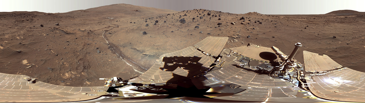
Twelve Years Ago, Spirit Rover Lands on Mars. This mosaic image taken on Jan. 4, 2004, by the navigation camera on the Mars Exploration Rover Spirit, shows a 360 degree panoramic view of the rover on the surface of Mars. Spirit operated for more than six years after landing in January 2004 for what was planned as a three-month mission. Credit: NASA/JPL
Twelve Years Ago, Spirit Rover Lands on Mars . This mosaic image taken on Jan. 4, 2004, by the navigation camera on the Mars Exploration Rover Spirit, shows a 360 degree panoramic view of the rover on the surface of Mars. Spirit operated for more than six years after landing in January 2004 for what was planned as a three-month mission. Credit: NASA/JPL
Exactly 12 Years ago this week, NASA’s now famous Spirit rover touched down on the Red Planet, starting a spectacular years long campaign of then unimaginable science adventures that ended up revolutionizing our understanding of Mars due to her totally unexpected longevity.
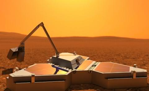
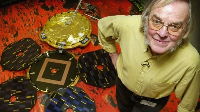
Artist's concept of the Norther Light Lander on the Martian surface.
Credit: Mars Rocks
The first Canadian mission to Mars could be blasting off towards the Red Planet in just three years time. At least, that is what Thoth Technology, a Canadian aerospace company from Pembroke, Ontario, hopes to accomplish. And two days ago, they launched an Indiegogo campaign to raise the 1.1 million dollars needed to pay for all the hardware needed to make the mission happen.
If it is successful, it would be first Canadian mission to the surface of Mars.
The project for this Canadian mission would involve sending the Northern Light lander and Beaver rover in space and land them on Mars. Once there, the Beaver rover will be deployed and begin conducting surveys of the Martian surface, alongside the many other robotic rovers and orbiters studying the Martian landscape.
“I think it’s important to do big things,” said Ben Quine, principal investigator for the mission. “Mars is the only other habitable planet in the solar system, and if we want to survive, we need to be a multi-planet species.”
Quine is the technical director and chair of the board at Thoth Technology and a professor of space engineering at York University, which is a partner on the project, houses a lot of the space testing facilities, and will analyze the data from the mission.
Northern Light Lander and Robotic Arm (concept art). Credit: Mars Rocks/Indiegogo
The main goal of the mission is to expand upon the efforts being made by NASA’s Curiosity, Spirit, and Opportunity rovers, which have only explored a half dozen sites on Mars. By exploring more areas, they hope to find other signs of life on the harsh landscape, and using knowledge gleaned from studies in the Canadian Arctic no less.
According to Quine, in Antarctica and the Canadian Arctic, photosynthetic microbes can be found in a layer a millimeter or two below the surface of the rock. Here, they are protected from the harshest of the sun’s UV rays, but can still use sunlight to produce energy.
Northern Light will look for similar life on Mars by using the lander’s robotic arm to grind away the surface of rocks. It will then use a device called a photometer to scan for different shades of green that may indicate the presence of photosynthetic organisms. Quine and his colleagues also hope to determine what future technologies will be required to sustain a future human presence.
“If we are serious about living on Mars,” he said, “we need to explore it much more thoroughly. We probably need hundreds of landers to pepper the surface prior to sending people so we know exactly what it is that we’re up against, where we’d find things like minerals and where we’d want to live.”
Intrinsic to the company’s plan is the widespread exploration of Mars using low cost, off-the-shelf technology. For example, the Northern Light lander probe has a mass under 50 kg (including payload) and is made of an advanced composite material that includes thermal shielding and shock absorption. The probe includes solar arrays to generate power for the instrumentation and lander avionics.
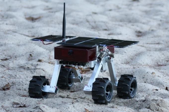
The Beaver Rover prototype. Credit: Thoth Technologies/Indiegogo
As for the Beaver rover, its small size and low-cost mask the fact that it is like no other rover that has ever gone to Mars. For one thing, it weighs just six kilograms (13 pounds). In comparison, NASA’s Curiosity rover weighs in at a hefty 900 kilograms (1980 pounds, close to an imperial ton), forcing it to rely largely on nuclear power to lug its bulk around.
The NASA rovers, which are controlled from Earth, also move very slowly and cover only a few dozen meters per day because their commands take 15 minutes to reach Mars from Earth. By contrast, the Beaver rover is designed to be quicker, in part by being more independent.
“We’re going to embed intelligence into the rover,” Quine said, “and the rover is going to be tasked to drive around and explore the environment using autonomous algorithms built into the rover to determine things like when it should make a maneuver to avoid falling into a hole or run into a rock.”
Quine said he has already spent 12 years working on the project and his team has spent half a million dollars developing and testing prototypes of the lander and micro-rover. They’ve also performed space tests on some of the instruments by flying them on satellites in low-Earth orbit.
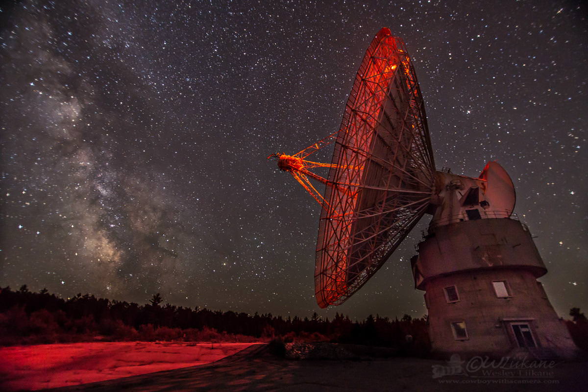
Northern Light Ground Station at the Algonquin Radio Observatory. Credit: Mars Rocks/Indiegogo
Thoth Technologies also recently spent $1 million leasing and repairing the Algonquin Radio Observatory from the federal government, which they plan to use as a ground station to communicate with the lander and rover when they are on Mars.
As for the tricky task of getting to Mars, Quine and his colleagues hope to barter their way aboard one of the many missions heading to Mars in 2018. These include the joint Russian-European Space Agency ExoMars rover mission and an Indian Space Research Organization mission that will likely include a lander and rover.
In exchange for hitching a ride on one of these rockets, they will collect and relay other agencies’ data from Mars via the ARO ground station, which can collect them at times of day when places like Russia and India are facing away from Mars.
Those who are interested in supporting their campaign are being incentivized with a chance to help choose the landing site for the mission, and will get rewards ranging from a Frisbee for $20 or the chance to name the lander for $1 million.
The company has also launched a social campaign – featuring Ed Robertson of the “Barenaked Ladies” – urging people to create and upload their own “Mars dance” video to marsrocks.ca.
To find out more, check out their promotional video or click on the link below:
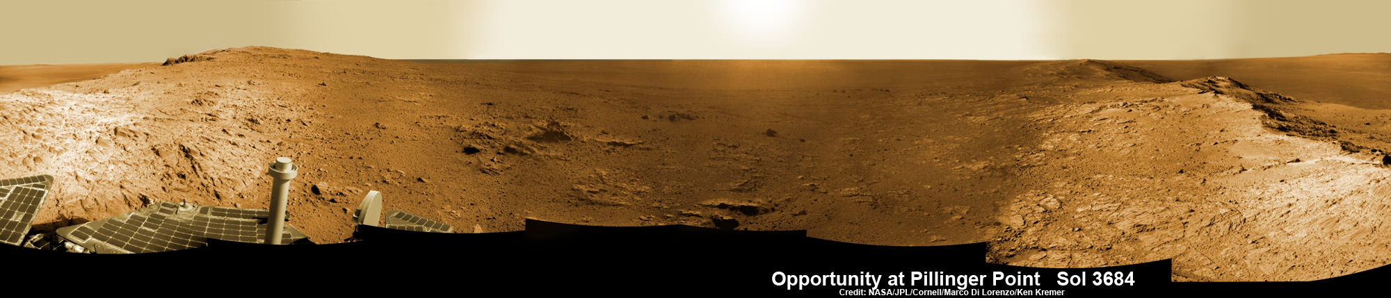
Opportunity Mars rover peers into vast Endeavour Crater from Pillinger Point mountain ridge named in honor of Colin Pillinger, the Principal Investigator for the British Beagle 2 lander built to search for life on Mars. Pillinger passed away from a brain hemorrhage on May 7, 2014. This navcam camera photo mosaic was assembled from images taken on June 5, 2014 (Sol 3684) and colorized. Credit: NASA/JPL/Cornell/Marco Di Lorenzo/Ken Kremer-kenkremer.com
NASA’s decade old Opportunity rover has reached a long sought after region of aluminum-rich clay mineral outcrops at a new Endeavour crater ridge now “named ‘Pillinger Point’ after Colin Pillinger the Principal Investigator for the [British] Beagle 2 Mars lander”, Prof. Ray Arvidson, Deputy Principal Investigator for the rover, told Universe Today exclusively. See above the spectacular panoramic view from ‘Pillinger Point’ – where ancient water once flowed billions of year ago.
The Beagle 2 lander was built to search for signs of life on Mars.
The Mars Exploration Rover (MER) team named the noteworthy ridge in honor of Prof. Colin Pillinger – a British planetary scientist at the Open University in Milton Keynes, who passed away at the age of 70 on May 7, 2014.
‘Pillinger Point’ is a scientifically bountiful place possessing both clay mineral outcrops and mineral veins where “waters came up through the cracks”, Arvidson explained to me.
Since water is a prerequisite for life as we know it, this is a truly fitting tribute to name Opportunity’s current exploration site ‘Pillinger Point’ after Prof. Pillinger.
See our new photo mosaic above captured by Opportunity peering out from ‘Pillinger Point’ ridge on June 5, 2014 (Sol 3684) and showing a panoramic view around the eroded mountain ridge and into vast Endeavour crater.
The gigantic crater spans 14 miles (22 kilometers) in diameter.
See below our Opportunity 10 Year traverse map showing the location of Pillinger Point along the segmented rim of Endeavour crater.
British planetary scientist Colin Pillinger with the Beagle 2 lander.
Pillinger Point is situated south of Solander Point and Murray Ridge along the western rim of Endeavour in a region with caches of clay minerals indicative of an ancient Martian habitable zone.
For the past several months, the six wheeled robot has been trekking southwards from Solander towards the exposures of aluminum-rich clays – now named Pillinger Point- detected from orbit by the CRISM spectrometer aboard NASA’s powerful Martian ‘Spysat’ – the Mars Reconnaissance Orbiter (MRO) – while gathering context data at rock outcrops along the winding way.
“We are about 3/5 of the way along the outcrops that show an Al-OH [aluminum-hydroxl] montmorillonite [clay mineral] signature at 2.2 micrometers from CRISM along track oversampled data,” Arvidson told me.
“We have another ~160 meters to go before reaching a break in the outcrops and a broad valley.”
The rover mission scientists ultimate goal is travel even further south to ‘Cape Tribulation’ which holds a motherlode of the ‘phyllosilicate’ clay minerals based on extensive CRISM measurements accomplished earlier at Arvidson’s direction.
“The idea is to characterize the outcrops as we go and then once we reach the valley travel quickly to Cape Tribulation and the smectite valley, which is still ~2 km to the south of the present rover location,” Arvidson explained.
Mars Express and Beagle 2 were launched in 2003, the same year as NASA’s twin rovers Spirit and Opportunity, on their interplanetary voyages to help unlock the mysteries of Mars potential for supporting microbial life forms.
Pillinger was the driving force behind the British built Beagle 2 lander which flew to the Red Planet piggybacked on ESA’s Mars Express orbiter. Unfortunately Beagle 2 vanished without a trace after being deployed from the orbiter on Dec. 19, 2003 with an expected air bag assisted landing on Christmas Day, Dec. 25, 2003.
In an obituary by the BBC, Dr David Parker, the chief executive of the UK Space Agency, said that Prof. Pillinger had played a critical role in raising the profile of the British space programme and had inspired “young people to dream big dreams”.
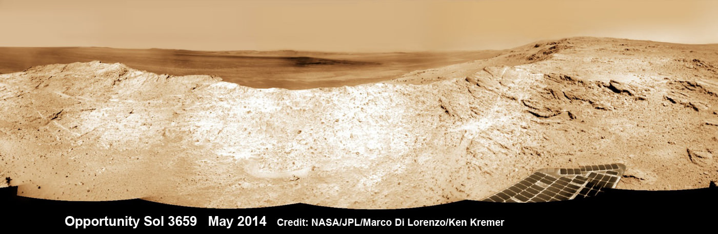
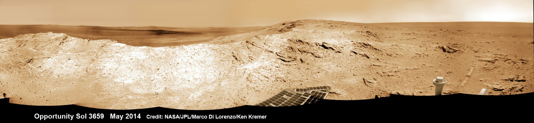
NASA’s Opportunity Mars rover captures sweeping panoramic vista near the ridgeline of 22 km (14 mi) wide Endeavour Crater’s western rim. The center is southeastward and also clearly shows the distant rim. See the complete panorama below. This navcam panorama was stitched from images taken on May 10, 2014 (Sol 3659) and colorized. Credit: NASA/JPL/Cornell/Marco Di Lorenzo/Ken Kremer-kenkremer.com
During his distinguished career Pillinger also analyzed lunar rock samples from NASA’s Apollo moon landing missions and worked on ESA’s Rosetta mission.
“It’s important to note that Colin’s contribution to planetary science goes back to working on Moon samples from Apollo, as well as his work on meteorites,” Dr Parker told the BBC.
Today, June 16, marks Opportunity’s 3696th Sol or Martian Day roving Mars – compared to a warranty of just 90 Sols.
So far she has snapped over 193,400 amazing images on the first overland expedition across the Red Planet.
Her total odometry stands at over 24.51 miles (39.44 kilometers) since touchdown on Jan. 24, 2004 at Meridiani Planum.
NASA’s Opportunity Mars rover captures sweeping panoramic vista near the ridgeline of 22 km (14 mi) wide Endeavour Crater’s western rim. The center is southeastward and the distant rim is visible in the center. An outcrop area targeted for the rover to study is at right of ridge. This navcam panorama was stitched from images taken on May 10, 2014 (Sol 3659) and colorized. Credit: NASA/JPL/Cornell/Marco Di Lorenzo/Ken Kremer-kenkremer.com
Meanwhile on the opposite side of Mars, Opportunity’s younger sister rover Curiosity is trekking towards gigantic Mount Sharp after drilling into her 3rd Red Planet rock at Kimberley.
Stay tuned here for Ken’s continuing Curiosity, Opportunity, Orion, SpaceX, Boeing, Orbital Sciences, MAVEN, MOM, Mars and more planetary and human spaceflight news.
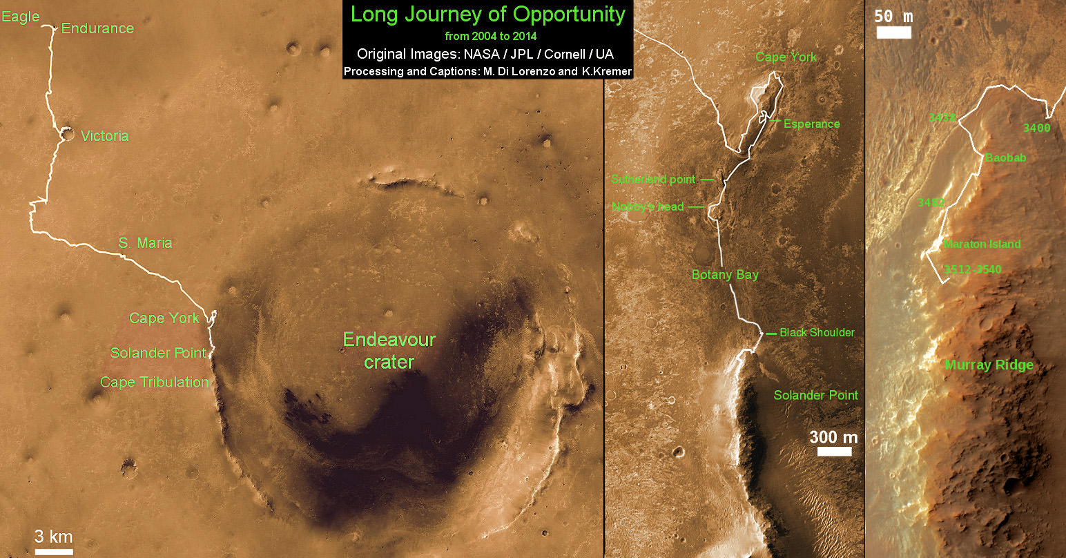
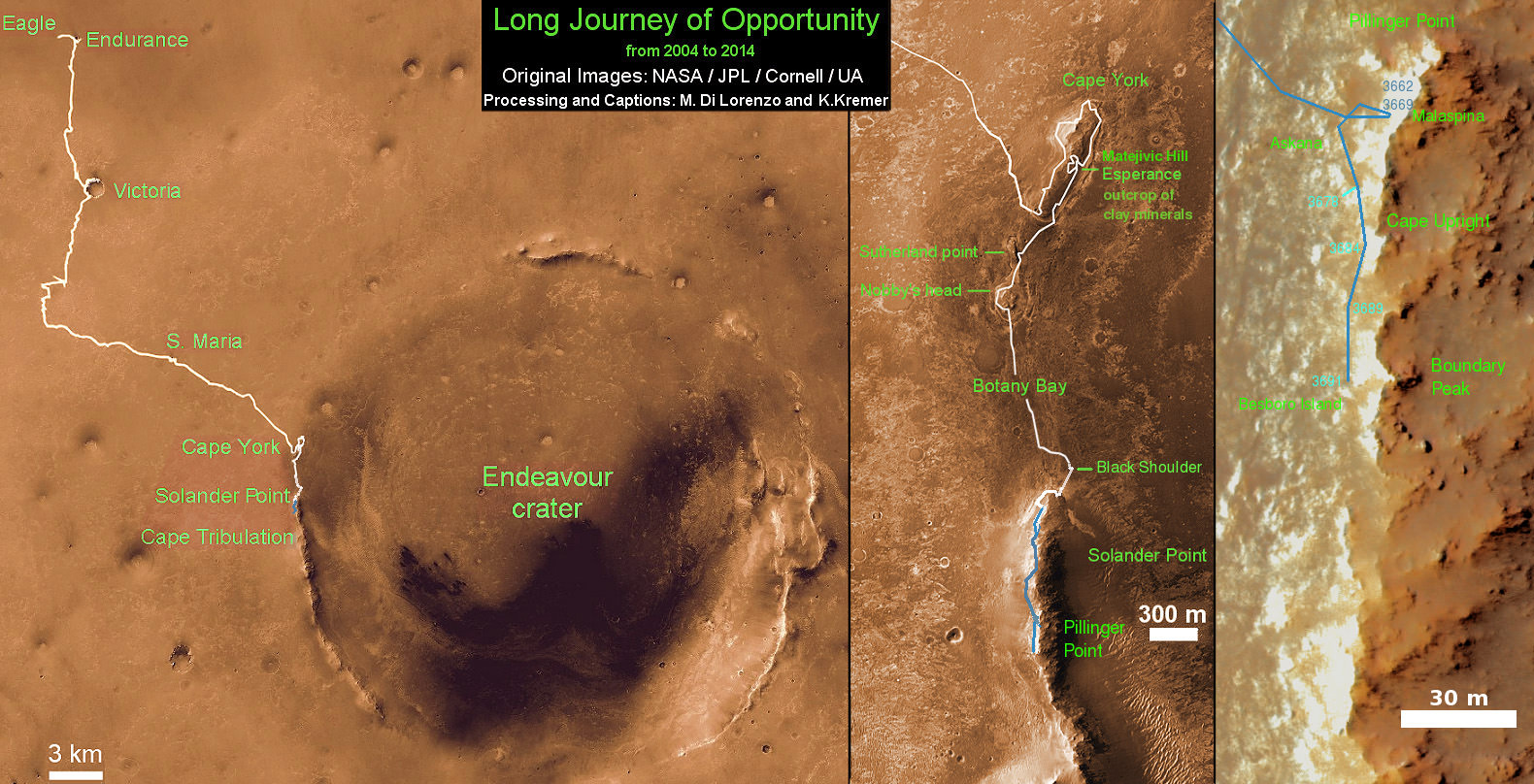
Traverse Map for NASA’s Opportunity rover from 2004 to 2014 – A Decade on Mars
This map shows the entire path the rover has driven during a decade on Mars and over 3692 Sols, or Martian days, since landing inside Eagle Crater on Jan 24, 2004 to current location along Pillinger Point ridge south of Solander Point summit at the western rim of Endeavour Crater and heading to clay minerals at Cape Tribulation. Opportunity discovered clay minerals at Esperance – indicative of a habitable zone. Credit: NASA/JPL/Cornell/ASU/Marco Di Lorenzo/Ken Kremer
Carbonate-Containing Martian Rocks discovered by Spirit Mars Rover. Spirit collected data in late 2005 which confirmed that the Comanche outcrop contains magnesium iron carbonate, a mineral indicating the past environment was wet and non-acidic, possibly favorable to life. This view was captured during Sol 689 on Mars (Dec. 11, 2005). The find at Comanche is the first unambiguous evidence from either Spirit or Opportunity for a past Martian environment that may have been more favorable to life than the wet but acidic conditions indicated by the rovers' earlier finds. Credit: NASA/JPL-Caltech/Cornell University
A Top 10 Decade 1 Discovery by NASA’s Twin Mars Exploration Rovers
Carbonate-Containing Martian Rocks discovered by Spirit Mars Rover
Spirit collected data in late 2005 which confirmed that the Comanche outcrop contains magnesium iron carbonate, a mineral indicating the past environment was wet and non-acidic, possibly favorable to life. This view was captured during Sol 689 on Mars (Dec. 11, 2005). The find at Comanche is the first unambiguous evidence from either Spirit or Opportunity for a past Martian environment that may have been more favorable to life than the wet but acidic conditions indicated by the rovers’ earlier finds. Credit: NASA/JPL-Caltech/Cornell University Story updated[/caption]
January 2014 marks the 10th anniversary since the nail biting and history making safe landings of NASA’s renowned Mars Explorations Rovers – Spirit and Opportunity – on the Red Planet barely three weeks apart during January 2004.
Due to their completely unforeseen longevity, a decade of spectacular and groundbreaking scientific discoveries continuously flowed from the robot sisters that have graced many articles, magazine covers, books, documentaries and refereed scientific papers.
What are the Top 10 Decade 1 discoveries from Spirit and Opportunity?
Find out below what a top Mars rover team scientist told Universe Today!
Ray Arvidson, the rovers Deputy Principal Investigator and professor at Washington University in St. Louis, has kindly shared with me his personal list of the Top 10 discoveries from Spirit and Opportunity for the benefit of readers of Universe Today.
The Top 10 list below are Ray’s personal choices and does not necessarily reflect the consensus of the Mars Explorations Rover (MER) team.
First some background.
The dynamic duo were launched on their interplanetary voyages from Cape Canaveral Florida atop Delta II rockets during the summer of 2003.
The now legendary pair landed on opposite sides of the Red Planet. Spirit landed first on Jan. 3 inside Gusev Crater and twin sister Opportunity landed second on Jan. 24 on the dusty plains of Meridiani Planum.
A Moment Frozen in Time
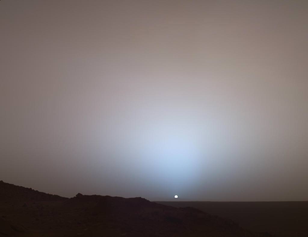
On May 19th, 2005, NASA’s Mars Exploration Rover Spirit captured this stunning view as the Sun sank below the rim of Gusev crater on Mars. This Panoramic Camera (Pancam) mosaic was taken around 6:07 in the evening of Sol 489. The terrain in the foreground is the rock outcrop “Jibsheet,” a feature that Spirit has been investigating for several weeks (rover tracks are dimly visible leading up to “Jibsheet”). The floor of Gusev crater is visible in the distance, and the Sun is setting behind the wall of Gusev some 80 km (50 miles) in the distance. Credit: NASA/JPL-Caltech/Texas A&M/Cornell
The goal was to “follow the water” as a potential enabler for past Martian microbes if they ever existed.
Together, the long-lived, golf cart sized robots proved that early Mars was warm and wet, billions of years ago – a key finding in the search for habitats conducive to life beyond Earth.
The solar powered robo duo were expected to last a mere three months – with a ‘warrenty’ of 90 Martian days (Sols).
Spirit endured the utterly extreme Red Planet climate for more than six years until communications ceased in 2010.
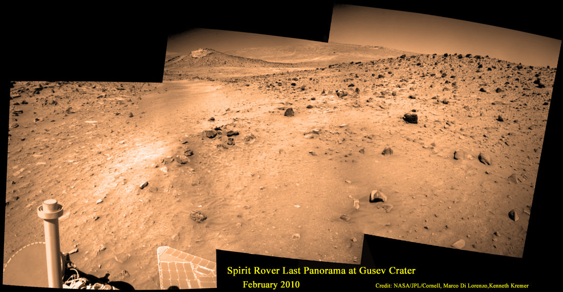
Last View from Spirit rover on Mars
Spirit’s last panorama from Gusev Crater was taken during February 2010 before her death from extremely low temperatures during her 4th Martian winter. Spirit was just 500 feet from her next science target – dubbed Von Braun – at center, with Columbia Hills as backdrop. Mosaic Credit: Marco Di Lorenzo/ Kenneth Kremer/ NASA/JPL/Cornell University.
Mosaic featured on Astronomy Picture of the Day (APOD) on 30 May 2011 – http://apod.nasa.gov/apod/ap110530.html
Opportunity lives on TODAY and is currently exploring by the summit of Solander Point on the western rim of a vast crater named Endeavour that spans some 22 kilometers (14 miles) in diameter.
“Because of the rovers’ longevity, we essentially got four different landing sites for the price of two,” says the rovers’ Principal Investigator, Steve Squyres of Cornell University, Ithaca, N.Y.
Here are the Top 10 MER discoveries from Ray Arvidson, Deputy Principal Investigator
1. Opportunity: Ancient Acidic Martian Lakes
The Meridiani plains Burns formation as sulfate-rich sandstones with hematitic concretions formed in ancient acidic and oxidizing shallow lakes and reworked into sand dunes and cemented by rising groundwaters.
‘Burns Cliff’ Color Panorama Opportunity captured this view of “Burns Cliff” after driving right to the base of this southeastern portion of the inner wall of “Endurance Crater.” The view combines frames taken by Opportunity’s panoramic camera between the rover’s 287th and 294th martian days (Nov. 13 to 20, 2004). The mosaic spans more than 180 degrees side to side. Credit: NASA/JPL-Caltech/Cornell
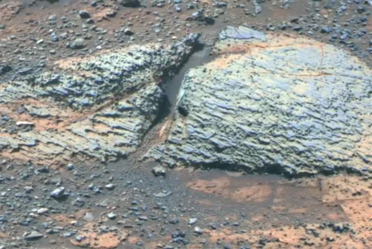
2. Opportunity: Phyllosilicate Clays at ‘Whitewater Lake’ at Endeavour Crater indicate Ancient Habitable Zone
At the rim of Endeavour crater and the Cape York rim segment the discovery of ferric and aluminous smectite [phyllosilicate] clays in the finely-layered Matijevic formation rocks that pre-exist the Endeavour impact event.
Pancam false-color view acquired on Sol 3066 (Sept. 8 2012) of fine-scale layering in the Whitewater Lake locality that is indicative of an ancient aqueous environment on Mars. Veneers have been resistant to wind erosion and enhanced the layered appearance of the outcrop. Layers are typically several millimeters thick. Credit: NASA/JPL-Caltech/Cornell/Arizona State University
Alteration in moderately acidic and reducing waters, perhaps mildly oxidizing for ferric smectites. These are the oldest rocks examined by Opportunity and the waters are much more habitable than waters that led to Burns formation.
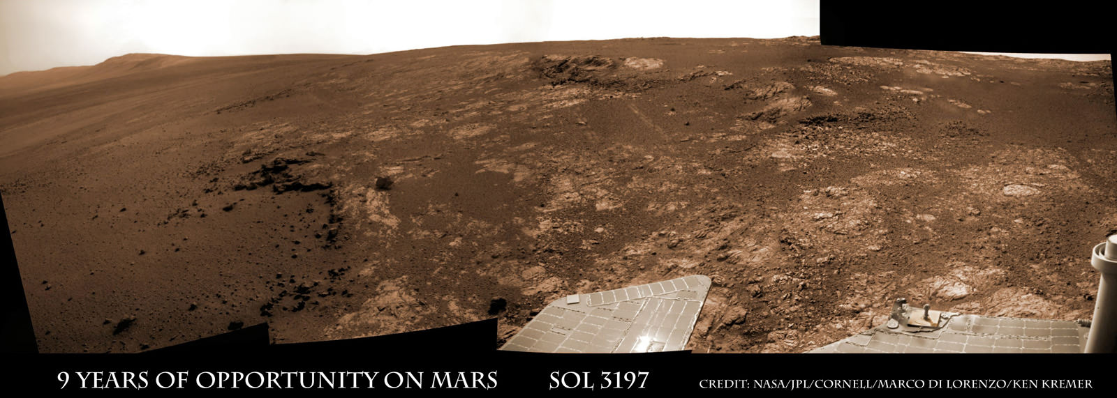
Opportunity rover discovered phyllosilicate clay minerals and calcium sulfate veins at the bright outcrops of ‘Whitewater Lake’, at right, imaged by the Navcam camera on Sol 3197 (Jan. 20, 2013, coinciding with her 9th anniversary on Mars. “Copper Cliff” is the dark outcrop, at top center. Darker “Kirkwood” outcrop, at left, is site of mysterious “newberries” concretions. This panoramic view was snapped from ‘Matijevic Hill’ on Cape York ridge at Endeavour Crater. Credit: NASA/JPL-Caltech/Cornell/Marco Di Lorenzo/Ken Kremer
3. Opportunity: Martian Meteorites
Many meteorites were found [throughout the long traverse] that are dispersed across the Meridiani plains landing site
4. Opportunity: Wind-blown sand ripples
Wind-blown sand ripples throughout the Meridiani plains relict from the previous wind regime, probably when Mars spin axis tilt was different than today’s value
5. Spirit: Opaline silica indicates Ancient Hydrothermal system
Discovery of Opaline silica at Home Plate, Gusev Crater. This formed in volcanic fumeroles and/or hydrothermal vents indicating that water was interacting with magma.
Spirit acquired this mosaic on Sol 1202 (May 21, 2007), while investigating the area east of the elevated plateau known as “Home Plate” in the “Columbia Hills.” The mosaic shows an area of disturbed soil, nicknamed “Gertrude Weise” by scientists, made by Spirit’s stuck right front wheel. The trench exposed a patch of nearly pure silica, with the composition of opal. It could have come from either a hot-spring environment or an environment called a fumarole, in which acidic, volcanic steam rises through cracks. Either way, its formation involved water, and on Earth, both of these types of settings teem with microbial life. Credit: NASA/JPL-Caltech/Cornell
6. Spirit: Carbonates at Comanche – see lead image above
The discovery of Fe-Mg [iron-magnesium] carbonates at the Comanche outcrop on Husband Hill, Gusev Crater, again showing that water interacted with magma.
Note: Carbonates form in neutral, non-acid water. This was the first time they were found and investigated examined on the surface Mars during Dec. 2005.
7. Spirit: Ferric sulfates moved by modern water
Ferric sulfates moved down the soil column by modern waters at Troy and Husband Hill in Gusev Crater.
‘Calypso’ Panorama of Spirit’s View from ‘Troy’. This full-circle view from the panoramic camera (Pancam) on NASA’s Mars Exploration Rover Spirit shows the terrain surrounding the location called “Troy,” where Spirit became embedded in soft soil during the spring of 2009. The hundreds of images combined into this view were taken beginning on the 1,906th Martian day (or sol) of Spirit’s mission on Mars (May 14, 2009) and ending on Sol 1943 (June 20, 2009). Credit: NASA/JPL-Caltech/Cornell University
8. Spirit: Modern water alters rocks
Complex coatings on olivine basalts on the Gusev Crater plains showing modern water or frost has altered rock surfaces
9. Both rovers: Martian Dust Devils
The finding [and imaging] of dust devil frequency and dynamics, showing how dust and sand are moved by wind in the very thin Martian atmosphere.
Note: Wind action occasionally cleaning off the solar panels led to their unexpected longevity
See a dust devil imaged in our Solander Point mosaic below
Spirit Mars rover – view from Husband Hill summit – panels cleaned by wind action
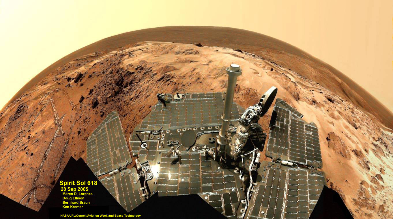
Spirit snapped this unique self portrait view from the summit of Husband Hill inside Gusev crater on Sol 618 on 28 September 2005. The rovers were never designed or intended to climb mountains. It took more than 1 year for Spirit to scale the Martian mountain. This image was created from numerous raw images by an international team of astronomy enthusiasts and appeared on the cover of the 14 November 2005 issue of Aviation Week & Space Technology magazine and the April 2006 issue of Spaceflight magazine. Also selected by Astronomy Picture of the Day (APOD) on 28 November 2005. Credit: NASA/JPL/Cornell/ Marco Di Lorenzo/Doug Ellison/Bernhard Braun/Ken Kremer – kenkremer.com
10. Both rovers: Atmospheric Argon measurements
Argon gas was used as a tracer of atmospheric dynamics by both rovers. It was measured by using the APXS (Alpha Particle X-Ray Spectrometer) on the robotic arm to measure the Martian atmosphere and detect argon
Another major discovery by Opportunity was the finding of hydrated mineral veins of calcium sulfate in the bench surrounding Cape York. The vein discovery is another indication of the ancient flow of liquid water in this region on Mars.
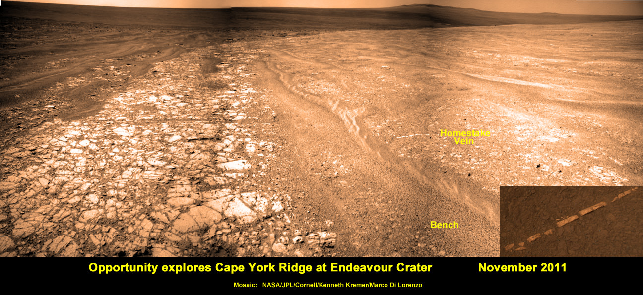
Opportunity discovers hydrated Mineral Vein at Endeavour Crater – November 2011. Opportunity determined that the ‘Homestake’ mineral vein was composed of calcium sulfate,or gypsum, while exploring around the base of Cape York ridge at the western rim of Endeavour Crater. The vein discovery indicates the ancient flow of liquid water at this spot on Mars. This panoramic mosaic of images was taken on Sol 2761, November 2011, and illustrates the exact spot of the mineral vein discovery. Featured on NASA Astronomy Picture of the Day (APOD) on 12 Dec 2011 – http://apod.nasa.gov/apod/ap111212.html. Credit: NASA/JPL/Cornell/Kenneth Kremer/Marco Di Lorenzo.
Altogether, Spirit snapped over 128,000 raw images, drove 4.8 miles (7.7 kilometers) and ground into 15 rock targets.
Opportunity is currently investigating a new cache of exposed clay mineral outcrops by the summit of Solander Point, a rim segment just south of Cape York and Matejivic Hill.
These new outcrops at ‘Cape Darby’ like those at ‘Esperance’ at Matijevic Hill were detected based on spectral observations by the CRISM spectrometer aboard NASA’s Mars Reconnaissance Orbiter (MRO) circling overhead, Arvidson told me.
Opportunity by Solander Point peak – 2nd Mars Decade Starts here!
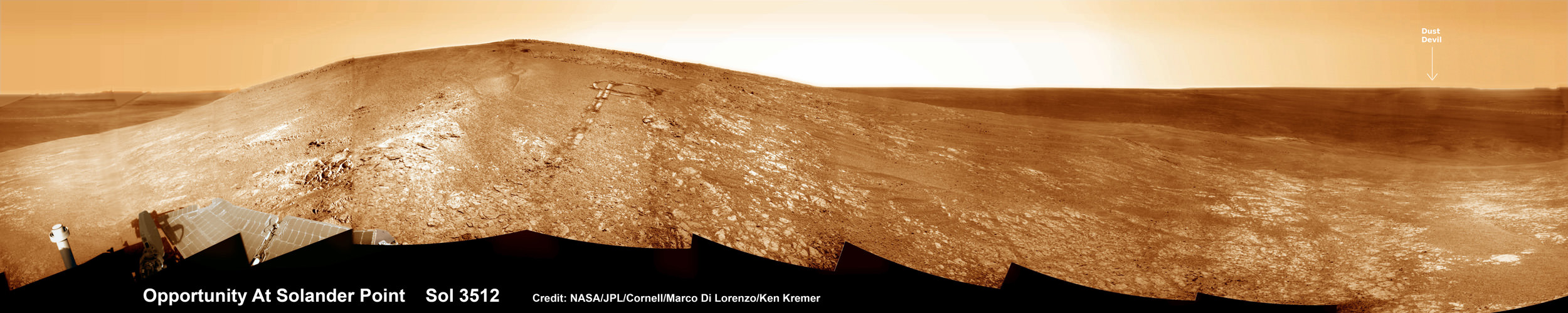
NASA’s Opportunity rover captured this panoramic mosaic on Dec. 10, 2013 (Sol 3512) near the summit of “Solander Point” on the western rim of vast Endeavour Crater where she starts Decade 2 on the Red Planet. She is currently investigating summit outcrops of potential clay minerals formed in liquid water on her 1st mountain climbing adventure. See wheel tracks at center and dust devil at right. Assembled from Sol 3512 navcam raw images. Credit: NASA/JPL/Cornell/Marco Di Lorenzo/Ken Kremer-kenkremer.com
Today, Jan. 31, marks Opportunity’s 3563rd Sol or Martian Day roving Mars – for what was expected to be only a 90 Sol mission.
So far she has snapped over 188,200 amazing images on the first overland expedition across the Red Planet.
Her total odometry stands at over 24.07 miles (38.73 kilometers) since touchdown on Jan. 24, 2004 at Meridiani Planum.
Meanwhile on the opposite side of Mars, Opportunity’s younger sister rover Curiosity is trekking towards gigantic Mount Sharp. She celebrated 500 Sols on Mars on New Years Day 2014.
What’s Ahead for Opportunity in Decade 2 on Mars ?
Many more ground breaking discoveries surely lie ahead for Opportunity since she is currently exploring ancient terrain at Endeavour crater that’s chock full of minerals indicative of a Martian habitable zone.
She remains healthy and the solar panels are generating enough power to actively continue science investigations throughout her 6th frigid Martian winter!
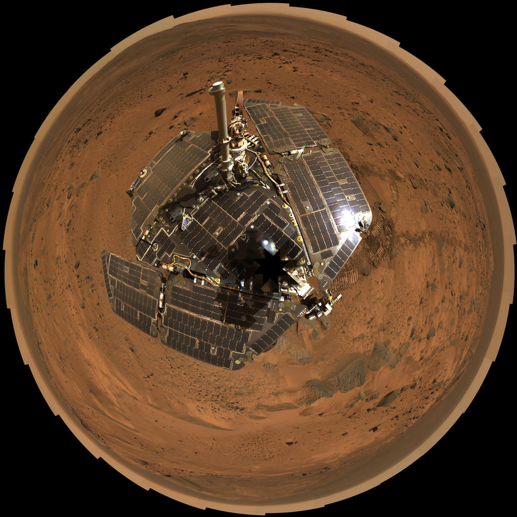
NASA’s Opportunity Mars rover recorded the component images for this self-portrait near the peak of Solander Point and about three weeks before completing a decade of work on Mars. The rover’s panoramic camera (Pancam) took the images during the interval Jan. 3, 2014, to Jan. 6, 2014. Credit: NASA/JPL-Caltech/Cornell/Arizona State University
Therefore – Stay tuned here for Ken’s continuing Opportunity, Curiosity, Chang’e-3, LADEE, MAVEN, Mars rover and MOM news.
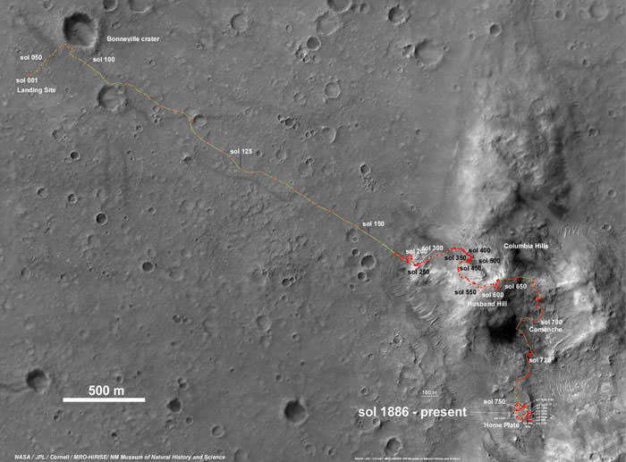
Spirit Rover traverse map from Gusev Crater landing site to Home Plate: 2004 to 2011Traverse Map for NASA’s Opportunity rover from 2004 to 2014
This map shows the entire path the rover has driven during a decade on Mars and over 3560 Sols, or Martian days, since landing inside Eagle Crater on Jan 24, 2004 to current location by Solander Point summit at the western rim of Endeavour Crater. Rover will spend 6th winter here atop Solander. Opportunity discovered clay minerals at Esperance – indicative of a habitable zone. Credit: NASA/JPL/Cornell/ASU/Marco Di Lorenzo/Ken Kremer – kenkremer.com
Pancam false-color view acquired on Sol 3066 (Sept. 8 2012) of fine-scale layering in the Whitewater Lake locality that is indicative of an ancient aqueous environment on Mars. Veneers have been resistant to wind erosion and enhanced the layered appearance of the outcrop. Layers are typically several millimeters thick. Credit: NASA/JPL-Caltech/Cornell/Arizona State University
After a decade of roving relentlessly on the Red Planet, NASA’s Opportunity rover discovered rocks that preserve the best evidence yet that ancient Mars was the most conducive time period for the formation of life on our Solar System’s most Earth-like Planet, according to the science leaders of the mission.
Opportunity found the rocks – laden with clay minerals – barely over half a year ago in the spring of 2013, at an outcrop named ‘Whitewater Lake’ along an eroded segment of a vast crater named Endeavour that spans some 22 kilometers (14 miles) in diameter.
“These rocks are older than any we examined earlier in the mission, and they reveal more favorable conditions for microbial life than any evidence previously examined by investigations with Opportunity,” says Opportunity Deputy Principal Investigator Ray Arvidson, a professor at Washington University in St. Louis.
Opportunity investigated the rocks at a spot dubbed Matejivic Hill where researchers believe iron-rich smectite was produced in an aqueous environment some 4 billion years ago that was relatively benign and with a nearly neutral pH – thus offering potential life forms a habitable zone with a far better chance to originate and thrive for perhaps as long as hundreds of millions of years.
The new scientific findings are being published in the journal Science on Jan. 24, which just happens to exactly coincide with Opportunity’s landing on the Red Planet ten years ago at Meridiani Planum.
Matejivic Hill is located on the Cape York rim segment of Endeavour crater. See locations on our Opportunity route map below.
“The punch line here is that the oldest rocks Opportunity has examined were formed under very mild conditions — conditions that would have been a much better niche for life, and also much better for the preservation of organic materials that would have been produced,” said Arvidson at a NASA media briefing today, Jan. 23.
Opportunity rover discovered phyllosilicate clay minerals and calcium sulfate veins at the bright outcrops of ‘Whitewater Lake’, at right, imaged by the Navcam camera on Sol 3197 (Jan. 20, 2013, coinciding with her 9th anniversary on Mars. “Copper Cliff” is the dark outcrop, at top center. Darker “Kirkwood” outcrop, at left, is site of mysterious “newberries” concretions. This panoramic view was snapped from ‘Matijevic Hill’ on Cape York ridge at Endeavour Crater. Credit: NASA/JPL-Caltech/Cornell/Marco Di Lorenzo/Ken Kremer
Immediately after landing on Mars on Jan.24, 2004 inside Eagle crater, the six wheeled robot found rocks within her eyesight that provided concrete evidence that eons ago Mars was much warmer and wetter compared to the cold, arid conditions that exist today.
Although those sulfate rich rocks proved that liquid water once flowed on the surface of the Red Planet, they also stem from a time period with a rather harsh environment that was extremely acidic, containing significant levels of sulfuric acid that would not be friendly to the formation or sustainability of potential Martian life forms.
“Evidence is thus preserved for water-rock interactions of the aqueous environments of slightly acidic to circum-neutral pH that would have been more favorable for prebiotic chemistry and microorganisms than those recorded by younger sulfate-rich rocks at Meridiani Planum,” Ardivson wrote in the Science paper, of which he is the lead author, along with many other team members.
NASA’s Opportunity Mars rover recorded the component images for this self-portrait near the peak of Solander Point and about three weeks before completing a decade of work on Mars. The rover’s panoramic camera (Pancam) took the images during the interval Jan. 3, 2014, to Jan. 6, 2014. Credit: NASA/JPL-Caltech/Cornell/Arizona State University
The science team directed Opportunity to Matejivic Hill and the ‘Whitewater Lake’ area of outcrops based on predictions from spectral observations collected from the CRISM spectrometer aboard one of NASA’s spacecraft circling overhead the Red Planet – the powerful Mars Reconnaissance Orbiter (MRO).
Opportunity arrived at Mars barely 3 weeks after her twin sister, Spirit on 3 January 2004.
The long lived robot has been methodically exploring along the rim of Endeavour crater since arriving in August 2011.
The newly published results from Opportunity correlate very well with those from sister rover Curiosity which likewise found a habitable zone where drinkable water once flowed on the opposite side of Mars.
The combined discoveries from the golf cart sized Opportunity and the SUV sized Curiosity tell us that the presence of liquid water was widespread on ancient Mars.
“The more we explore Mars, the more interesting it becomes. These latest findings present yet another kind of gift that just happens to coincide with Opportunity’s 10th anniversary on Mars,” said Michael Meyer, lead scientist for NASA’s Mars Exploration Program.
“We’re finding more places where Mars reveals a warmer and wetter planet in its history. This gives us greater incentive to continue seeking evidence of past life on Mars.”
Opportunity is currently investigating a new cache of clay mineral outcrops by the summit of Solander Point, a rim segment just south of Cape York and Matejivic Hill.
These outcrops were likewise detected by the CRISM spectrometer aboard MRO. The hunt for these outcrops was detailed in earlier discussions I had with Ray Arvidson.
Opportunity by Solander Point peak – her 1st mountain climbing adventure. NASA’s Opportunity rover captured this panoramic mosaic on Dec. 10, 2013 (Sol 3512) near the summit of “Solander Point” on the western rim of Endeavour Crater where she is investigating outcrops of potential clay minerals. Assembled from Sol 3512 navcam raw images. Credit: NASA/JPL/Cornell/Marco Di Lorenzo/Ken Kremer-kenkremer.com
Today marks Opportunity’s 3555th Sol or Martian Day roving Mars – for what was expected to be only a 90 Sol mission.
So far she has snapped over 188,200 amazing images on the first overland expedition across the Red Planet.
Her total odometry stands at over 24.07 miles (38.73 kilometers) since touchdown on Jan. 24, 2004 at Meridiani Planum.
Meanwhile on the opposite side of Mars, Opportunity’s younger sister rover Curiosity is trekking towards gigantic Mount Sharp. She celebrated 500 Sols on Mars on New Years Day 2014.
Opportunity by Solander Point peak – 2nd Mars Decade Starts here! NASA’s Opportunity rover captured this panoramic mosaic on Dec. 10, 2013 (Sol 3512) near the summit of “Solander Point” on the western rim of Endeavour Crater where she starts Decade 2 on the Red Planet. She is currently investigating outcrops of potential clay minerals formed in liquid water on her 1st mountain climbing adventure. Assembled from Sol 3512 navcam raw images. Credit: NASA/JPL/Cornell/Marco Di Lorenzo/Ken Kremer-kenkremer.comTraverse Map for NASA’s Opportunity rover from 2004 to 2014
This map shows the entire path the rover has driven during a decade on Mars and over 3540 Sols, or Martian days, since landing inside Eagle Crater on Jan 24, 2004 to current location by f Solander Point summit at the western rim of Endeavour Crater. Rover will spnd 6th winter here atop Solander. Opportunity discovered clay minerals at Esperance – indicative of a habitable zone. Credit: NASA/JPL/Cornell/ASU/Marco Di Lorenzo/Ken Kremer
Opportunity by Solander Point peak – 2nd Mars Decade Starts here! NASA’s Opportunity rover captured this panoramic mosaic on Dec. 10, 2013 (Sol 3512) near the summit of “Solander Point” on the western rim of Endeavour Crater where she starts Decade 2 on the Red Planet. She is currently investigating outcrops of potential clay minerals formed in liquid water on her 1st mountain climbing adventure. Assembled from Sol 3512 navcam raw images. Credit: NASA/JPL/Cornell/Marco Di Lorenzo/Ken Kremer-kenkremer.com
Opportunity by Solander Point peak – 2nd Mars Decade Starts here!
NASA’s Opportunity rover captured this panoramic mosaic on Dec. 10, 2013 (Sol 3512) near the summit of “Solander Point” on the western rim of Endeavour Crater where she starts Decade 2 on the Red Planet. She is currently investigating outcrops of potential clay minerals formed in liquid water on her 1st mountain climbing adventure. Assembled from Sol 3512 navcam raw images. Credit: NASA/JPL/Cornell/Marco Di Lorenzo/Ken Kremer-kenkremer.com
See full mosaic with Dust Devil and 10 Year Route Map – below Story updated[/caption]
NASA’s long-lived Opportunity Mars rover has accomplished what absolutely no one expected.
Opportunity is about to embark on her 2nd decade exploring the Red Planet since her nail biting touchdown in 2004.
And to top that off she is marking that miraculous milestone at a spectacular outlook by the summit of the first mountain she has ever scaled!
See our Solander Point summit mosaic showing the robots current panoramic view – in essence this is what her eyes see today; above and below.
And that mountaintop is riven with outcrops of minerals that likely formed in flowing liquid neutral water conducive to life – potentially a scientific goldmine.
“We expect we will reach some of the oldest rocks we have seen with this rover — a glimpse back into the ancient past of Mars,” says the rover principal investigator, Steve Squyres of Cornell University, Ithaca, N.Y.
“It’s like starting a whole new mission.”
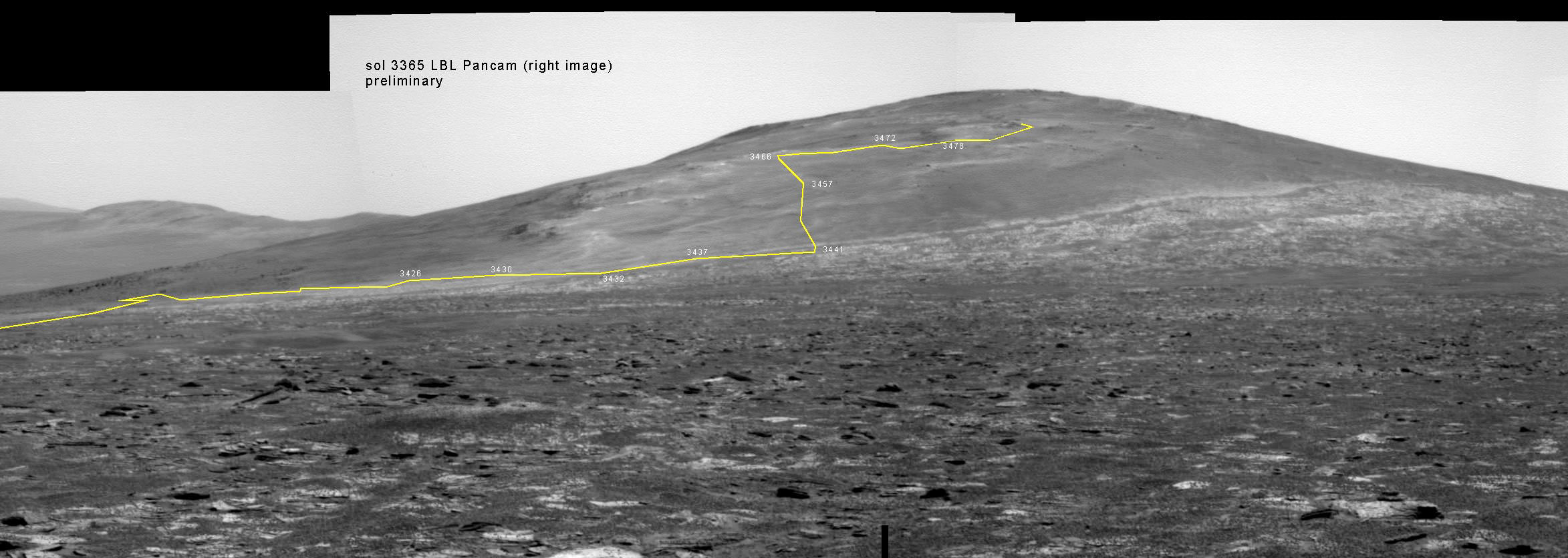
Back on sol 3365 we took this image of Solander Point as we approached it. Here I have plotted the subsequent route that Opportunity has taken in climbing up the ridge. The outcrop shown I the images below are near the end of the yellow traverse line. Caption and mosaic by Larry Crumpler/NASA/JPL
Opportunity is nearly at the peak of Solander Point, an eroded segment on the western flank of vast Endeavour Crater, that spans some 22 kilometers (14 miles) in diameter.
The six wheeled rover reached the top section of Solander on Sol 3512, just before Christmas in December 2013. It’s situated nearly 40 meters (130 feet) above the crater plains.
There she began inspecting and analyzing an area of exposed outcrops called ‘Cape Darby’ that scientists believe holds caches of clay minerals which form in drinkable water and would constitute a habitable zone.
Opportunity by Solander Point peak – 2nd Mars Decade Starts here!
NASA’s Opportunity rover captured this panoramic mosaic on Dec. 10, 2013 (Sol 3512) near the summit of “Solander Point” on the western rim of vast Endeavour Crater where she starts Decade 2 on the Red Planet. She is currently investigating summit outcrops of potential clay minerals formed in liquid water on her 1st mountain climbing adventure. See wheel tracks at center and dust devil at right. Assembled from Sol 3512 navcam raw images.
Credit: NASA/JPL/Cornell/Marco Di Lorenzo/Ken Kremer-kenkremer.com
The science team directed Opportunity to ‘Cape Darby’ based on predictions from spectral observations collected from the CRISM spectrometer aboard one of NASA’s spacecraft circling overhead the Red Planet – the powerful Mars Reconnaissance Orbiter (MRO).
Opportunity is using all its cameras and instruments as well as those on the robotic arm to inspect the outcrop area, including the rock abrasion tool, spectrometers and microscopic imager.
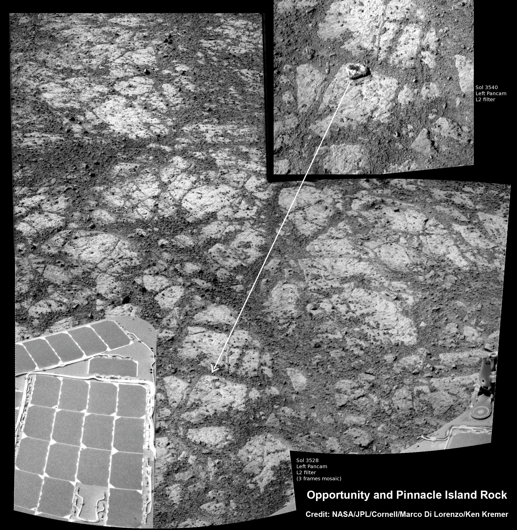
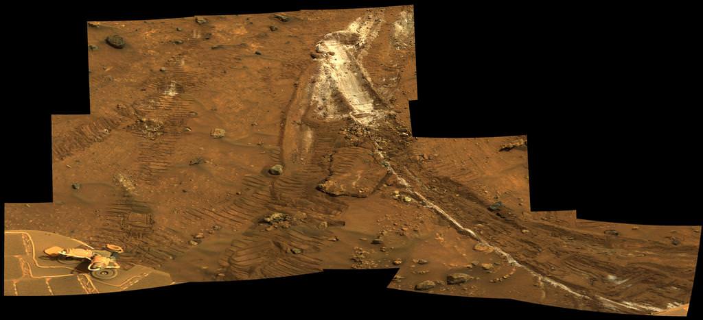
As reported earlier this week, the rover is also investigating a mysterious rock that suddenly appeared in images nearby the robot. ‘Pinnacle Island’ rock may have been flung up by the wheels. No one knows for sure – yet.
Mosaic of Opportunity and mysterious Pinnacle Island rock by Solander Point peak. Mysterious Pinnacle Island rock suddenly appeared out of nowhere in images snapped on Sol 3540. It was absent in earlier images on Sol 3528. This mosaic shows the rock nearby the solar panels of NASA’s Opportunity rover. Assembled from Sol 3528 and 3540 pancam raw images. Credit: NASA/JPL/Cornell/Marco Di Lorenzo/Ken Kremer-kenkremer.com
Solander Point is the first mountain she has ever climbed along her epic 10 year journey across the plains of Meridiani. Heretofore she toured a string of Martian craters. See 10 Years Route map below.
In mid-2013, the scientists used similar orbital observations to find a rock called “Esperance’ – which was loaded with clay minerals and located along another Endeavour crater rim segment called Cape York.
Squyres ranked “Esperance” as one of the “Top 5 discoveries of the mission.”
The team hopes for similar mineralogical discoveries at Solander.
The northward-facing slopes at Solander also afford another major benefit to Opportunity. They will tilt the rover’s solar panels toward the sun in the southern-hemisphere winter sky thereby providing an important energy boost.
The power boost will enable continued mobile operations through the upcoming frigidly harsh winter- her 6th since landing 10 years ago.
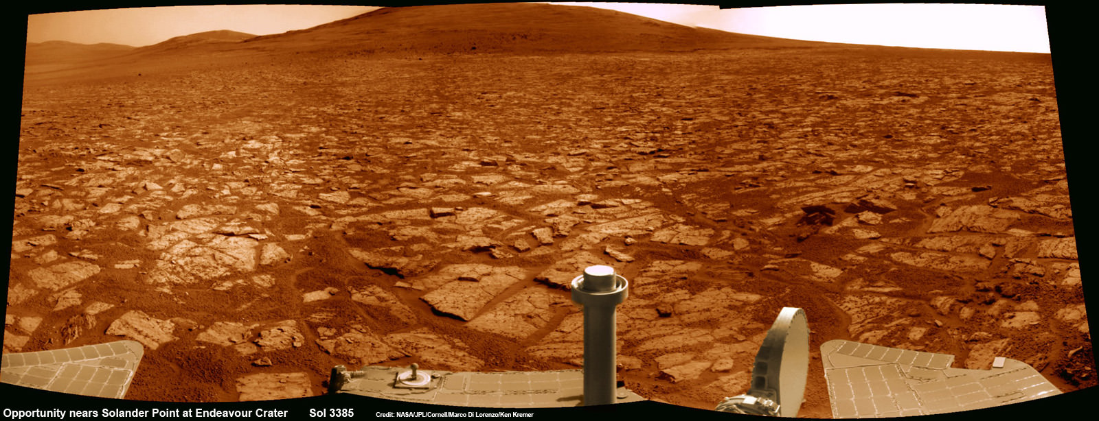
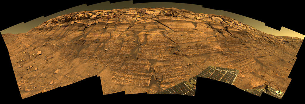
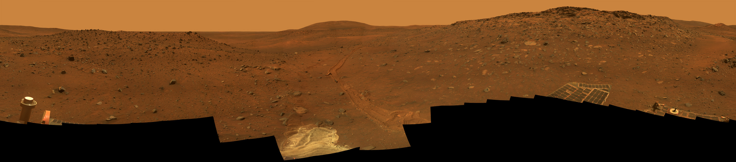
Opportunity rover’s 1st mountain climbing goal is dead ahead in this up close view of Solander Point at Endeavour Crater. Opportunity has ascended the mountain looking for clues indicative of a Martian habitable environment. This navcam panoramic mosaic was assembled from raw images taken on Sol 3385 (Aug 2, 2013). Credit: NASA/JPL/Cornell/Marco Di Lorenzo/Ken Kremer (kenkremer.com)
So Opportunity will be moving from outcrop to outcrop around the summit during the Martian winter. Daily sunshine reaches a minimum in February 2014.
As of Wednesday, Jan. 15, 2014, or Sol 3547, the solar array energy production on the rover is 353 watt-hours, compared to 900 watt-hours after landing. But that is sufficient to keep moving and actively conduct research throughout the winter at the mountaintop.
Opportunity’s long and winding road on the Red Planet began when she safely settled upon the alien world on 24 January 2004, following a harrowing plummet through the thin Martian atmosphere and an airbag assisted, bouncing ball landing.
Meanwhile on the opposite side of Mars, Opportunity’s younger sister rover Curiosity is trekking towards gigantic Mount Sharp. She celebrated 500 Sols on Mars on New Years Day 2014.
And a pair of new orbiters are streaking to the Red Planet to fortify the Terran fleet- NASA’s MAVEN and India’s MOM.
Opportunity starts scaling Solander Point
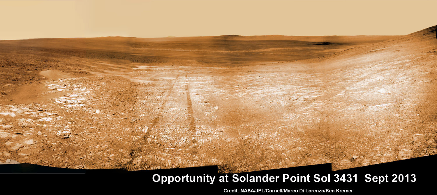
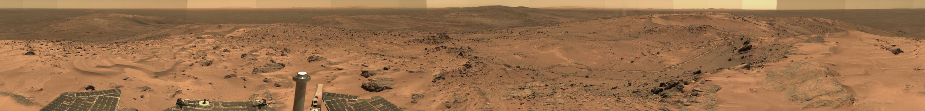
See the tilted terrain and rover tracks in this look-back mosaic view from Solander Point peering across the vast expanse of huge Endeavour Crater. Moasic assembled from navcam raw images taken on Sol 3431 (Sept.18, 2013). Credit: NASA/JPL/Cornell/Marco Di Lorenzo/Ken Kremer – kenkremer.comTraverse Map for NASA’s Opportunity rover from 2004 to 2014 – A Decade on Mars
This map shows the entire path the rover has driven during a decade on Mars and over 3552 Sols, or Martian days, since landing inside Eagle Crater on Jan 24, 2004 to current location by f Solander Point summit at the western rim of Endeavour Crater. Rover will spnd 6th winter here atop Solander. Opportunity discovered clay minerals at Esperance – indicative of a habitable zone. Credit: NASA/JPL/Cornell/ASU/Marco Di Lorenzo/Ken Kremer
A Moment Frozen in Time On May 19th, 2005, NASA's Mars Exploration Rover Spirit captured this stunning view as the Sun sank below the rim of Gusev crater on Mars. This Panoramic Camera (Pancam) mosaic was taken around 6:07 in the evening of Sol 489. The terrain in the foreground is the rock outcrop "Jibsheet," a feature that Spirit has been investigating for several weeks (rover tracks are dimly visible leading up to "Jibsheet"). The floor of Gusev crater is visible in the distance, and the Sun is setting behind the wall of Gusev some 80 km (50 miles) in the distance. Credit: NASA/JPL-Caltech/Texas A&M/Cornell
A Moment Frozen in Time
On May 19th, 2005, NASA’s Mars Exploration Rover Spirit captured this stunning view as the Sun sank below the rim of Gusev crater on Mars. This Panoramic Camera (Pancam) mosaic was taken around 6:07 in the evening of Sol 489. The terrain in the foreground is the rock outcrop “Jibsheet,” a feature that Spirit has been investigating for several weeks (rover tracks are dimly visible leading up to “Jibsheet”). The floor of Gusev crater is visible in the distance, and the Sun is setting behind the wall of Gusev some 80 km (50 miles) in the distance.
Credit: NASA/JPL-Caltech/Texas A&M/Cornell
See photo gallery below[/caption]
But a decade ago, NASA’s six wheeled Spirit rover was but a promise of great things to come. And her rich Martian scientific heritage we know today was but a dream yet to ensue
Jan. 3 marks the 10th anniversary since her touchdown on Mars on Jan. 3, 2004. Her twin sister Opportunity soft landed 3 weeks later on Jan. 24, 2004.
So here’s a collection of some of Spirit’s greatest hits on the Red Planet for all to enjoy and remember her fabulous exploits.
Read my detailed new overview marking ‘Spirits 10 Years on Mars’ – here – with even more spectacular Red Planet imagery!
Empty Nest. Spirit rover images her Lander Platform after egress following touchdown in January 2004. Lander had 3-petals and airbags. Credit: NASA/JPL-Caltech/Cornell
Since the golf cart sized Spirit snapped over 128,000 raw images, drove 4.8 miles and ground into 15 rock targets we can’t show everything.
Here’s a retrospective of some of our favorites.
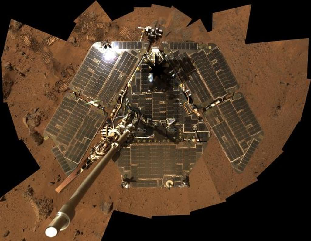
In this selfie, Spirit shows her solar panels gleaming in the Martian sunlight and carrying only a thin veneer of dust two years after the rover landed and began exploring the red planet. Spirit’s panoramic camera took this mosaic of images on Sol 586 (Aug. 27, 2005), as part of a mammoth undertaking. The vertical projection used here produces the best view of the rover deck itself, though it distorts the ground and antennas somewhat. This image is an approximate true-color rendering that combines images taken through the camera’s 600-nanometer, 530-nanometer and 480-nanometer filters. Credit: NASA/JPL-Caltech/Cornell
During her more than six year lifetime spanning until March 2010, Spirit discovered compelling evidence that ancient Mars exhibited hydrothermal activity, hot springs and volcanic explosions flowing with water.
“Spirit’s big scientific accomplishments are the silica deposits at Home Plate, the carbonates at Comanche, and all the evidence for hydrothermal systems and explosive volcanism, Rover Principal Investigator Steve Squyres of Cornell University, explained to me in an earlier interview.
“What we’ve learned is that early Mars at Spirit’s site was a hot, violent place, with hot springs, steam vents, and volcanic explosions. It was extraordinarily different from the Mars of today.”
Meanwhile, NASA’s new Curiosity rover just celebrated 500 Sols on Mars and is speeding towards Mount Sharp from inside Gale Crater – which is about the same size as Gusev crater.
Stay tuned here for Ken’s continuing Mars rover, Curiosity, Chang’e-3, SpaceX, Orbital Sciences, LADEE, MAVEN, MOM and more news.
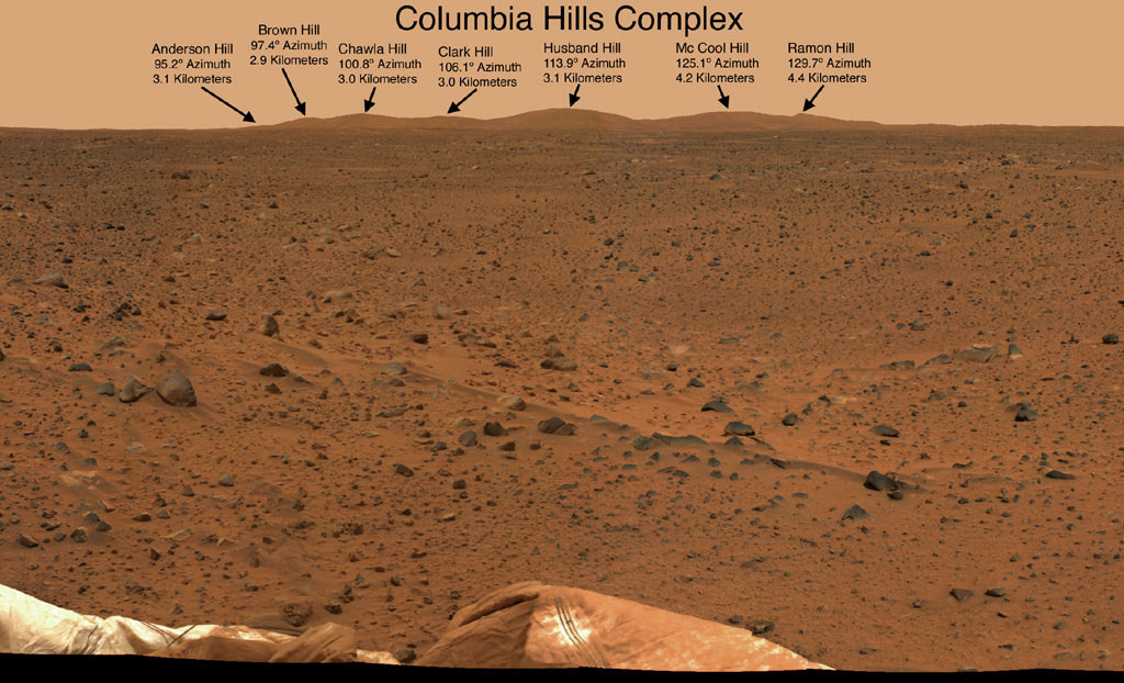
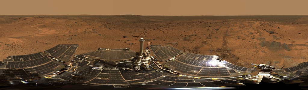
The “Columbia Hills” in Gusev Crater on Mars. “Husband Hill” is 3.1 kilometers distant. Spirit took this mosaic of images with the panoramic camera at the beginning of February, 2004, less than a month after landing on Mars. Spirit soon drove to the Columbia Hills and climbed to the summit of Husband Hill. Credit: NASA/JPL-Caltech/CornellSummit Panorama with Rover Deck The panoramic camera on Spirit took the hundreds of images combined into this 360-degree view, the “Husband Hill Summit” panorama. The images were acquired on Spirit’s sols 583 to 586 (Aug. 24 to 27, 2005), shortly after the rover reached the crest of “Husband Hill” inside Mars’ Gusev Crater. The panoramic camera shot 653 separate images in 6 different filters, encompassing the rover’s deck and the full 360 degrees of surface rocks and soils visible to the camera from this position. This was the first time the camera has been used to image the entire rover deck and visible surface from the same position. Credit: NASA/JPL-Caltech/CornellCarbonate-Containing Martian Rocks discovered by Spirit Mars Rover. Spirit collected data in late 2005 which confirmed that the Comanche outcrop contains magnesium iron carbonate, a mineral indicating the past environment was wet and non-acidic, possibly favorable to life. This view was captured during Sol 689 on Mars (Dec. 11, 2005). The find at Comanche is the first unambiguous evidence from either Spirit or Opportunity for a past Martian environment that may have been more favorable to life than the wet but acidic conditions indicated by the rovers’ earlier finds. Credit: NASA/JPL-Caltech/Cornell UniversityEverest Panorama from Husband Hill summit. It took Spirit three days, sols 620 to 622 (Oct. 1 to Oct. 3, 2005), to acquire all the images combined into this mosaic, called the “Everest Panorama”. Credit: NASA/JPL-Caltech/Cornell UniversitySpirit Mars rover – view from Husband Hill summit. Spirit snapped this unique self portrait view from the summit of Husband Hill inside Gusev crater on Sol 618 on 28 September 2005. The rovers were never designed or intended to climb mountains. It took more than 1 year for Spirit to scale the Martian mountain. This image was created from numerous raw images by an international team of astronomy enthusiasts and appeared on the cover of the 14 November 2005 issue of Aviation Week & Space Technology magazine and the April 2006 issue of Spaceflight magazine. Also selected by Astronomy Picture of the Day (APOD) on 28 November 2005. Credit: NASA/JPL/Cornell/ Marco Di Lorenzo/Doug Ellison/Bernhard Braun/Ken Kremer-kenkremer.com‘Calypso’ Panorama of Spirit’s View from ‘Troy’. This full-circle view from the panoramic camera (Pancam) on NASA’s Mars Exploration Rover Spirit shows the terrain surrounding the location called “Troy,” where Spirit became embedded in soft soil during the spring of 2009. The hundreds of images combined into this view were taken beginning on the 1,906th Martian day (or sol) of Spirit’s mission on Mars (May 14, 2009) and ending on Sol 1943 (June 20, 2009). Credit: NASA/JPL-Caltech/Cornell UniversitySpirit examined spectacular layered rocks exposed at “Home Plate.” The rover has drove around the northern and eastern edges of Home Plate. Before departing, Spirit took this image showing some of the most complex layering patterns seen so far at this location. Scientists suspect that the rocks at Home Plate were formed in the aftermath of a volcanic explosion or impact event, and they are investigating the possibility that wind may also have played a role in redistributing materials after such an event. Credit: NASA/JPL-Caltech/CornellSpirit Rover traverse map from Gusev Crater landing site to Home Plate: 2004 to 2011Spirit Rover traverse map from Husband Hill to resting place at Home Plate: 2004 to 2011
This bird's-eye view from August 2005 combines a self-portrait of the spacecraft deck and a panoramic mosaic of the Martian surface as viewed by NASA's Mars Exploration Rover Spirit. The rover's solar panels are still gleaming in the sunlight, having acquired only a thin veneer of dust two years after the rover landed and commenced exploring the red planet. Spirit captured this 360-degree panorama on the summit of "Husband Hill" inside Mars' Gusev Crater. During the period from Spirit's Martian days, or sols, 583 to 586 (Aug. 24 to 27, 2005), the rover's panoramic camera acquired the hundreds of individual frames for this largest panorama ever photographed by Spirit. Credit: NASA/JPL-Caltech/Cornell
Ten Years Ago, Spirit Rover Lands on Mars
This bird’s-eye view from August 2005 combines a self-portrait of the spacecraft deck and a panoramic mosaic of the Martian surface as viewed by NASA’s Mars Exploration Rover Spirit. The rover’s solar panels are still gleaming in the sunlight, having acquired only a thin veneer of dust two years after the rover landed and commenced exploring the red planet. Spirit captured this 360-degree panorama on the summit of “Husband Hill” inside Mars’ Gusev Crater. During the period from Spirit’s Martian days, or sols, 583 to 586 (Aug. 24 to 27, 2005), the rover’s panoramic camera acquired the hundreds of individual frames for this largest panorama ever photographed by Spirit. Credit: NASA/JPL-Caltech/Cornell
See Spirit’s 1st and last panoramas and more imagery below[/caption]
Today, Jan. 3, marks the 10th anniversary since the safe landing of NASA’s renowned Spirit rover on the plains of Mars on Jan. 3, 2004.
Spirit comprises one half of NASA’s now legendary pair of Mars Exploration Rovers (MER). Opportunity, her twin sister landed, on the opposite side of the Red Planet three weeks later – on Jan. 24, 2004. The goal was to “follow the water” as a potential enabler for past Martian microbes if they ever existed.
Together, the long-lived, golf cart sized robots proved that early Mars was warm and wet, billions of years ago – a key finding in the search for habitats conducive to life beyond Earth.
Exactly a decade ago, the famous robot survived the scorching atmospheric heating of the 6 minute plunge through the thin Martian atmosphere, bounced some two dozen times cocooned inside cushioning airbags, and gradually rolled to a stop inside 100 mile wide Gusev Crater. It was known as the “6 minutes of Terror”.
The three petaled landing pad opened and Spirit was dramatically born in a milestone event that will be forever remembered in the annuls of history because of the groundbreaking scientific discoveries that ensued and the unbelievable longevity of the twins.
Ten Years Ago, Spirit Rover Lands on Mars
This mosaic image taken on Jan. 4, 2004, by the navigation camera on the Mars Exploration Rover Spirit, shows a 360 degree panoramic view of the rover on the surface of Mars. Spirit operated for more than six years after landing in January 2004 for what was planned as a three-month mission. Credit: NASA/JPL
Before they were launched atop Delta II rockets in the summer of 2003 from Cape Canaveral, the dynamic, solar powered robo duo were expected to last a mere three months – with a ‘warranty’ of 90 Martian days (Sols).
Either dust accumulation on the life giving solar panels, an engineering issue or the extremely harsh Martian environment was expected to somehow terminate them mercilessly.
In reality, both robots enormously exceeded expectations and accumulated a vast bonus time of exploration and discovery in numerous extended mission phases.
‘McMurdo’ Panorama from Spirit’s ‘Winter Haven’
This beautiful scene reveals a tremendous amount of detail in Spirit’s surroundings at a place called “Winter Haven,” where the rover spent many months parked on a north-facing slope in order to keep its solar panels pointed toward the sun for the winter. During this time, it captured several images to create this high resolution panorama. During that time, while the rover spent the daylight hours conducting as much scientific research as possible, science team members assigned informal names to rock outcrops, boulders, and patches of soil commemorating exploration sites in Antarctica and the southernmost islands of South America. Antarctic bases are places where researchers, like the rovers on Mars, hunker down for the winter in subzero temperatures. During the past Martian winter, Spirit endured temperatures lower than minus 100 degrees Celsius (minus 148 degrees Fahrenheit). Credit: NASA/JPL/Cornell
No one foresaw that Martian winds would occasionally clean the solar panels to give them a new lease on life or that the components would miraculously continue functioning.
Spirit endured the utterly extreme Red Planet climate for more than six years until communications ceased in 2010.
Opportunity is still roving Mars today, and doing so in rather good condition!
Altogether, Spirit drove 4.8 miles (7.73 kilometers),that’s about 12 times more than the original goal set for the mission.
She transmitted over 128,000 images.
After landing in the dusty plains, she headed for the nearby Columbia Hills some 2 miles away and ultimately became the first Martian mountaineer, when she scaled Husband Hill and found evidence for the flow of liquid water at the Hillary outcrop.
Spirit acquired this mosaic on Sol 1202 (May 21, 2007), while investigating the area east of the elevated plateau known as “Home Plate” in the “Columbia Hills.” The mosaic shows an area of disturbed soil, nicknamed “Gertrude Weise” by scientists, made by Spirit’s stuck right front wheel. The trench exposed a patch of nearly pure silica, with the composition of opal. It could have come from either a hot-spring environment or an environment called a fumarole, in which acidic, volcanic steam rises through cracks. Either way, its formation involved water, and on Earth, both of these types of settings teem with microbial life. Credit: NASA/JPL-Caltech/Cornell
The rovers were not designed to climb hills. But eventually she scaled 30 degree inclines.
The rover was equipped with a rock grinder named the Rock Abrasion Tool (RAT) built by Honeybee Robotics.
Spirit ground the surfaces off 15 rock targets and scoured 92 targets with a brush to prepare the targets for inspection with spectrometers and a microscopic imager, according to NASA.
Eventually she drove back down the hill and made even greater scientific discoveries in the area known as ‘Home Plate’.
Spirit survived three harsh Martian winters and only succumbed to the Antarctic-like temperatures when she unexpectedly became mired in an unseen sand trap driving beside an ancient volcanic feature named ‘Home Plate’ that prevented the solar arrays from generating life giving power to safeguard critical electronic and computer components.
In 2007, Spirit made one of the key discoveries of the mission at ‘Home Plate’ when her stuck right front wheel churned up a trench of bright Martian soil that exposed a patch of nearly pure silica, which was formed in a watery hot spring or volcanic environment.
Spirit was heading towards another pair of volcanic objects named ‘von Braun’ and ‘Goddard’ and came within just a few hundred feet when she died in the sand trap.
See Spirits last panorama below – created from raw images taken in Feb. 2010 by Marco Di Lorenzo and Ken Kremer.
Last View from Spirit rover on Mars
Spirit’s last panorama from Gusev Crater was taken during February 2010 before her death from extremely low temperatures during her 4th Martian winter. Spirit was just 500 feet from her next science target – dubbed Von Braun – at center, with Columbia Hills as backdrop. Mosaic Credit: Marco Di Lorenzo/ Kenneth Kremer/ NASA/JPL/Cornell University. Mosaic featured on Astronomy Picture of the Day (APOD) on 30 May 2011 – http://apod.nasa.gov/apod/ap110530.html
Here’s how the rovers’ principal investigator, Steve Squyres of Cornell University, Ithaca, N.Y., described some of the key findings in a NASA statement, starting with what Spirit found after driving from the crater floor where it landed into the Columbia hills to the east:
“In the Columbia Hills, we discovered compelling evidence of an ancient Mars that was a hot, wet, violent place, with volcanic explosions, hydrothermal activity, steam vents — nothing like Mars today.
“At Opportunity’s landing site, we found evidence of an early Mars that had acidic groundwater that sometimes reached the surface and evaporated away, leaving salts behind. It was an environment with liquid water, but very different from the environment that Spirit told us about.
“When Opportunity got to the rim of Endeavour Crater, we began a whole new mission. We found gypsum veins and a rich concentration of clay minerals. The clay minerals tell us about water chemistry that was neutral, instead of acidic — more favorable for microbial life, if any ever began on Mars.”
“Because of the rovers’ longevity, we essentially got four different landing sites for the price of two.”
Meanwhile, NASA’s new Curiosity rover just celebrated 500 Sols on Mars and is speeding towards Mount Sharp from inside Gale Crater – which is about the same size as Gusev crater.
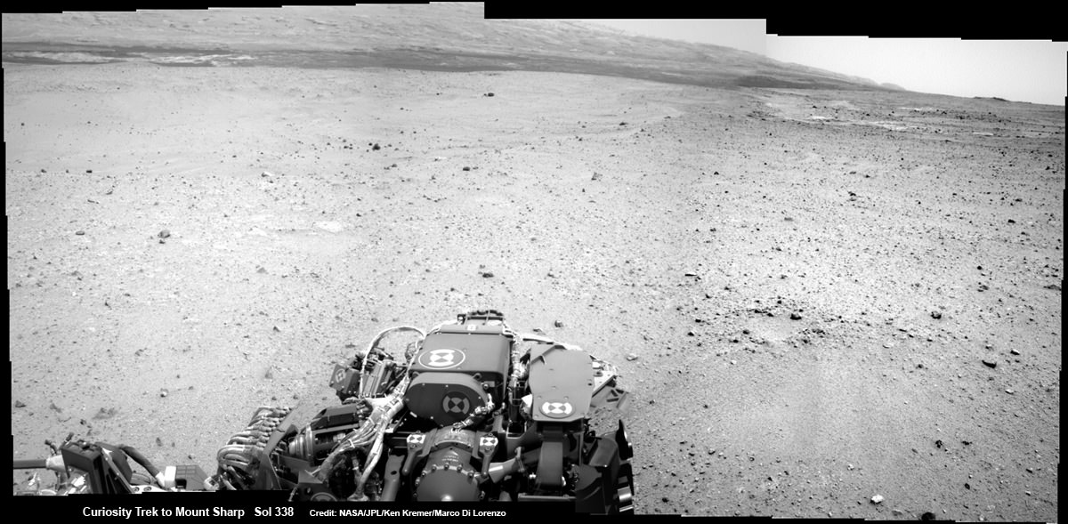
Curiosity On the Road to Mount Sharp and treacherous Sand Dunes - Sol 338 - July 19. Curiosity captured this panoramic view of the path ahead to the base of Mount Sharp and potentially dangerous sand dunes after her most recent drive on July 19, 2013. She must safely cross over the dark dune field to climb and reach the lower sedimentary layers of Mount Sharp. Credit: NASA/JPL-Caltech/Ken Kremer-(kenkremer.com)/Marco Di Lorenzo
Curiosity On the Road to Mount Sharp and treacherous Sand Dunes – Sol 338 – July 19
Curiosity captured this panoramic view of the path ahead to the base of Mount Sharp and potentially dangerous sand dunes after her most recent drive on July 19, 2013. She must safely cross over the dark dune field to climb and reach the lower sedimentary layers of Mount Sharp. Stowed robotic arm on rover deck seen at center.
See JPL traverse map below pinpointing the view from this location
Credit: NASA/JPL-Caltech/Ken Kremer-(kenkremer.com)/Marco Di Lorenzo[/caption]
NASA’s state-of-the-art Curiosity Mars rover is stepping up the driving pace and rolling relentlessly across alien Martian terrain towards the towering mystery mountain known as Mount Sharp that’s holds the keys to the Red Planets past evolution and whether its an abode for Life.
To uncover the latest scoop on the robots otherworldly adventures, Universe Today conducted an exclusive interview with the Curiosity Project Manager Jim Erickson, of NASA’s Jet Propulsion Laboratory (JPL).
In Part 2 of my conversation with Jim Erickson we’ll discuss more about the rover’s traverse across alien territory that’s simultaneously a science gold mine and a potential death trap, as well as Comet ISON and nighttime observations and science planning.
“When Comet ISON is in the sky I’m sure we’ll do some observations of it depending on when its visible,” Erickson told me.
Today, July 20, is Sol 339 of the rovers mission to Mars. And also the 44th anniversary of the 1st human Moonwalks in 1969.
And Curiosity just drove another 34 meters yesterday, Sol 338 (July 19) – for a total distance exceeding 1.1 kilometers.
Curiosity’s Traverse Map Through Sol 338
This map shows the route driven by NASA’s Mars rover Curiosity through Sol 338 of the rover’s mission on Mars (July 19, 2013). Numbering of the dots along the line indicate the sol number of each drive. North is up. The scale bar is 200 meters (656 feet). From Sol 337 to Sol 338, Curiosity had driven a straight line distance of about 122.90 feet (32.59 meters). The base image from the map is from the High Resolution Imaging Science Experiment Camera (HiRISE) in NASA’s Mars Reconnaissance Orbiter. Image Credit: NASA/JPL-Caltech/Univ. of Arizona
As for Martian sand dunes, they dunes offer both exciting opportunities and lurking dangers to the rovers well being.
Indeed fields of Martian sand dunes are potential death traps and the six wheeled rover has no choice but to traverse across an extensive dune field as she closes in on the base of Mount Sharp
Recall that NASA’s now long lived Opportunity rover nearly perished rather early in her mission at the ‘Purgatory’ dune field on Meridiani Planum.
Spirit died after more than six highly productive years on the Red Planet when she was unable to escape a hidden sand trap she had accidentally fallen wheels deep into as the vehicle was merrily roving beside an eroded volcano at Gusev Crater on the approach to the mysterious Von Braun mound.
So, dunes are serious business
Here is Part 2 of my interview with Jim Erickson.
Ken Kremer: Which direction is Curiosity headed? Will she be following the southwest route shown in the ellipse on the JPL map – see traverse map below – or reinvestigate any other spots nearer the landing site first?
Jim Erickson: We have a good general idea. We will be on a general heading of southwest, not west which would have taken us back near the landing site [at Bradbury Landing].
Curiosity Route Map From ‘Glenelg’ to Mount Sharp
This map shows where NASA’s Mars rover Curiosity landed in August 2012 at “Bradbury Landing”; the area where the rover worked from November 2012 through May 2013 at and near the “John Klein” target rock in the “Glenelg” area; and the mission’s next major destination, the entry point to the base of Mount Sharp. Credit: NASA/JPL-Caltech/Univ. of Arizona
Ken: So the rover will not pass by the Hottah outcrop of concretions formed in water and investigated early in the mission?
Jim Erickson: No. The intent for the ellipse [shown on the map] is that we will be traveling in it to get to an area where the sand dunes look better for crossing [to the base of Mount Sharp]. When we get there we will know reality. And we will pick a safe spot to cross.
The dunes can be both an issue or in some cases easy sailing.
My experience on MER [Spirit & Opportunity] was that when you are going with the dunes, down a trough, they tend to be well packed and that was great driving.
But if you need to make a right turn, that can be a challenge for a couple of reasons. It is harder to see what is inside the next trough. And you have to drive to the top of the dune. So your driving is limited until you can see what’s inside the next dune.
Level ground is more straightforward. You know exactly what to look for if the terrain doesn’t change the next day. So you can do the same thing you did last night based on the new set of images.
If the terrain is changing then it gets more complicated.
Ken: Will you be straddling the dunes or driving alongside some safe distance away?
Jim Erickson: We have been going through various options of different planned routes. At some point we have to go with the dune directions.
So we’ll be traveling down some troughs later on. We will definitely have to pick our way through them.
Part of it is gaining experience in this new area of Mars with how the sand dunes and troughs themselves actually are.
So we’ll have to wait and see. We know we’ll have to deal with the dunes. Depending on how these dunes act we may have to do different things compared to MER.
Ken: What’s the health status of Curiosity?
Jim Erickson: We’re doing great. There are always active things we are looking at.
We had the anomaly before conjunction and have put in place a number of software mitigations and reconfigured the A side memory so that we can work around the hardware problem that happened. If we have another problem, both the A and B side memory can handle it gracefully, unlike the last time.
Ken: Describe the rover’s power situation? And the ability to do nighttime observations like the recent imagery of Phobos rising?
And certainly will be able to do nighttime observations.
Ken: What’s the plan for observations of Comet ISON?
Jim Erickson: When we get to the point when Comet ISON is in the sky I’m sure we’ll do some observations of it, depending on the time period when its visible.
Note: NASA’s Curiosity and Opportunity rovers will have a view of ISON in October with Oct. 1, 2013, being the comet’s closest approach to Mars.
NASA’s Directory of Planetary Science Jim Green told me previously that NASA is very interested in using its orbiting and surface assets at Mars to study Comet ISON. It’s a once in a lifetime opportunity.
Early October 2013 will be the prime viewing time for ISON from the vicinity of the Red Planet.
Let’s hope that NASA’s quartet of spacecraft and ESA’s lone orbiter capture some breathtaking imagery and science observations.
Ken: About the recent Phobos nighttime images, a Universe Today reader asked whether the other points of light beside Phobos were stars or hot pixels?
Jim Erickson: The specks are hot pixels [not stars], intensified by the long exposure times for the image.
Video Caption: ‘Phobos Rising’ – This movie clip shows Phobos, the larger of the two moons of Mars, passing overhead, as observed by Curiosity in a series of images centered straight overhead starting shortly after sunset on June 28, 2013. Phobos first appears near the lower center of the view and moves toward the top of the view. The apparent ring is an imaging artifact. The other bright spots are hot pixels – not stars. Credit: NASA/JPL-Caltech
Ken: How about the prospects for science along the way to the mountain?
Jim Erickson: We expect to do science along the way to Mount Sharp, for example in terms of atmospheric measurements.
We will stop at some preplanned sites. Exactly which ones is still being debated by the scientists.
And we’ll do the right thing – If we see something spectacular along the way. Just because we may not have identified it previously, that doesn’t mean we won’t stop and examine it.
Things are going very well, says Erickson.
Erickson has worked in key positions on many NASA planetary science missions dating back to Viking in the 1970’s. These include the Galileo mission to Jupiter, both MER rovers Spirit & Opportunity, as well as a stint with the Mars Reconnaissance Orbiter (MRO).
I’ll have more upcoming from Jim about Curiosity’s Martian drilling activities.
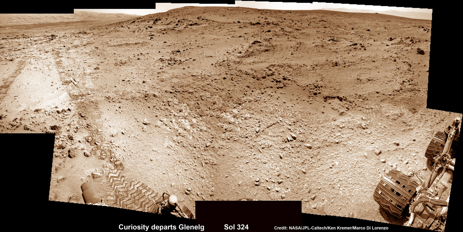
As of today (July 20) Curiosity has driven nine times since leaving the Glenelg/Yellowknife Bay area on July 4 (Sol 324), totaling nearly 300 meters.
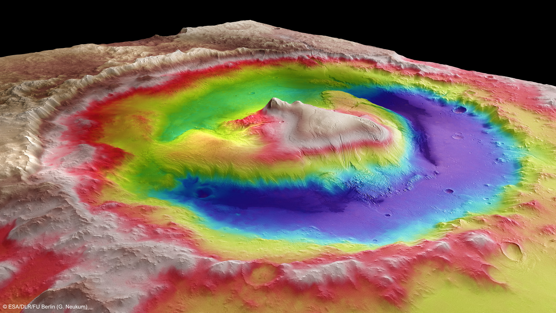
This photomosic shows NASA’s Curiosity departing at last for Mount Sharp- her main science destination. Note the wheel tracks on the Red Planet’s surface. The navcam camera images were taken on July 4, 2013 (Sol 324). Credit: NASA/JPL-Caltech/Ken Kremer (kenkremer.com)/Marco Di LorenzoMount Sharp inside Gale Crater – is the primary destination of NASA’s Curiosity rover mission to Mars. Curiosity landed on the right side of the mountain as shown here, near the dune field colored dark blue. Mount Sharp dominates Gale Crater. It is 3.4 mile (5.5 km) high. Gale Crater is 154 km wide. This image was taken by the High Resolution Stereo Camera (HRSC) of ESA’s Mars Express orbiter. Credit: ESA/DLR/FU Berlin (G. Neukum)


![MER10-SpiritAndOpportunity_ByTheNumbers[1]](https://www.universetoday.com/wp-content/uploads/2014/01/MER10-SpiritAndOpportunity_ByTheNumbers1.jpg)