2023 Carl Sagan Medal recipient, Dr. Tracy Becker, who is a group leader in the Southwest Research Institute’s Space Science Division. Dr. Becker is a planetary scientist whose research interests include remote observations of space phenomena such as the asteroid system shown here. (Credit: Southwest Research Institute)
This year’s prestigious Carl Sagan Medal, also known as the “Sagan Medal” and named after the late astronomer, Dr. Carl Sagan, has been awarded to Dr. Tracy Becker, who is a planetary scientist in the Space Science Division of the Southwest Research Institute (SwRI) in San Antonio, Texas. The Sagan Medal recipient is chosen by the Division for Planetary Sciences of the American Astronomical Society (AAS) and is meant to acknowledge planetary scientists who are not only active in science communication with the general public but have taken enormous strides in helping the general public better understand, and get excited for, the field of planetary science.
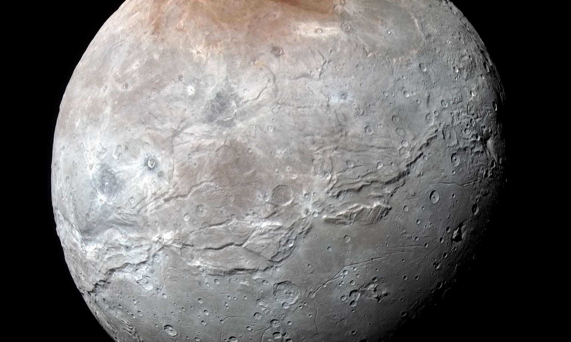
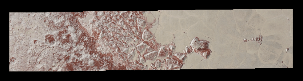
Pluto’s largest moon, Charon, started off as a beautiful, smooth red grape until someone came along, mostly peeled it, tried to smoosh it, then just gave up and walked away, leaving the poor moon to look like the absolute travesty that it is. Okay, so maybe that’s not exactly what happened, but Charon just looks like a mess and scientists want to know why. Never mind its smooshed equator, but what’s the deal with its red cap? Where did it come from and why is it red?
Artist’s Rendering of Lucy. Credit: Southwest Research Institute
A new study out this month suggests that Jupiter’s Trojan asteroids may be more peculiar than previously thought. The Trojan asteroids are rocky objects which orbit the Sun just ahead of and just behind the gas giant, in gravitational sweet spots known as Lagrange points. The swarm ahead of Jupiter, known as the L4 (Greek) group, is slightly larger than the L5 (Trojan) swarm behind, but until now, astronomers believed that there was otherwise little differentiation between the two swarms. The paper released this month appears to change that.
Scientists developed this illustration of how early Mars may have looked, showing signs of liquid water, large-scale volcanic activity and heavy bombardment from planetary projectiles. SwRI is modeling how these impacts may have affected early Mars to help answer questions about the planet’s evolutionary history. Image Credit: SwRI/Marchi
There are around 61,000 meteorites on Earth, or at least that’s how many have been found. Out of those, about 200 of them are very special: they came from Mars. And those 200 meteorites have been important clues to how Mars formed in the early Solar System.
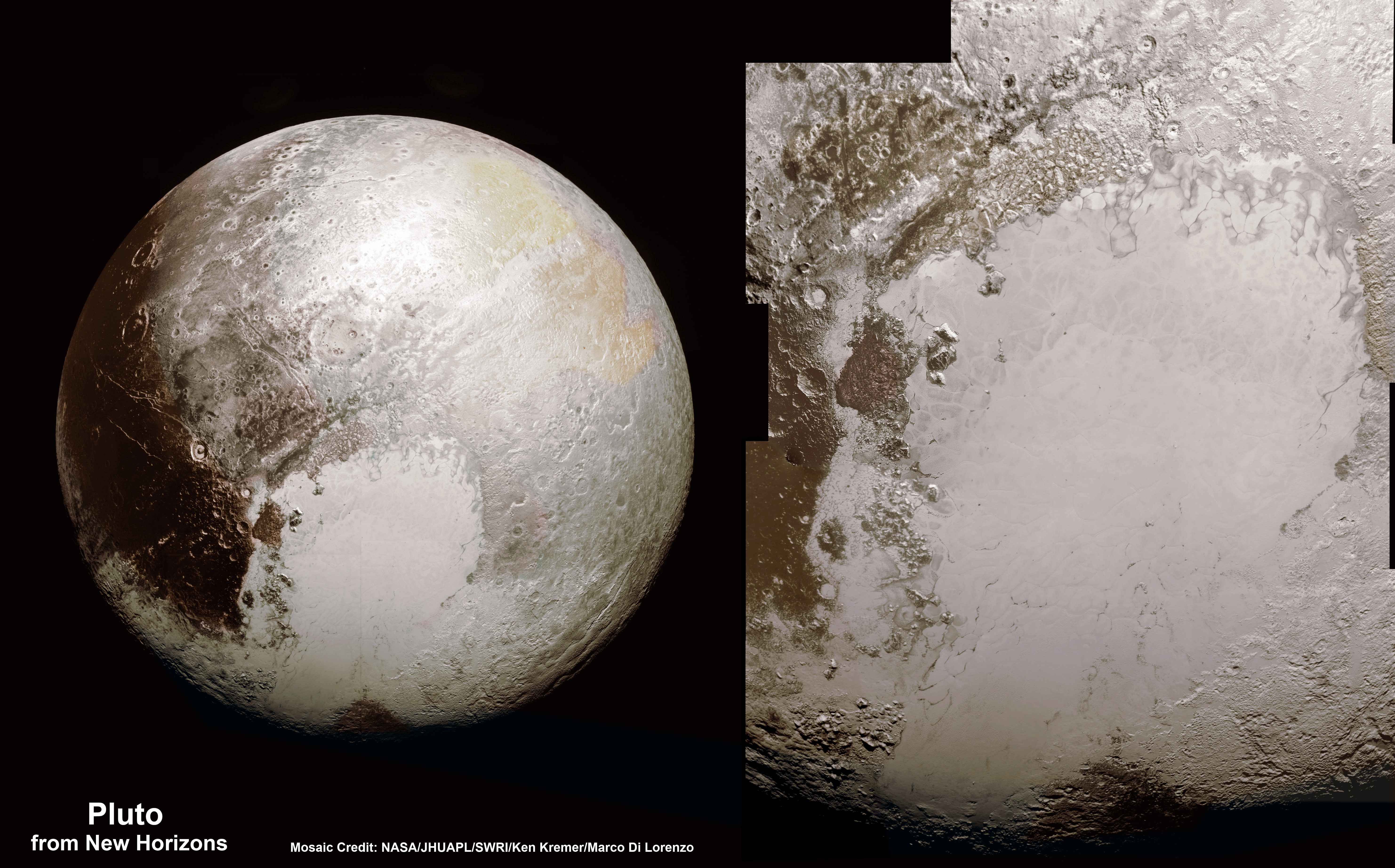
Far left: Pluto and it's heart-shaped feature
called “Tombaugh Regio” in honor of astronomer Clyde Tombaugh, who discovered
the dwarf planet. The bright expanse of the western lobe of Pluto’s “heart” is
informally called Sputnik Planum. Above left: Pluto’s surface sports a remarkable
range of landforms that have their own distinct colors, telling a complex geological
and climatological story.
Credit: Courtesy NASA / JHUAPL / SwRI
Table of Contents page
2015 Annual Report
Division: (15)
NASA’s New Horizons mission taught us a lot about Pluto, the ice dwarf planet. But the spacecraft sped past Pluto so quickly, we only got high-resolution images of one side of the planet, the so-called “encounter side.” New Horizons gave us a big leap in understanding, but in a way, it asked more questions than it answered.
The next step is clearly an orbiter, and now NASA is starting to seriously consider one.
Artist's impression of NASA's New Horizons spacecraft encountering a Pluto-like object in the distant Kuiper Belt. Credits: NASA/JHUAPL/SwRI/Alex Parker
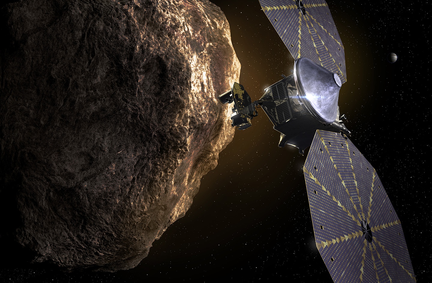
Since it made its historic flyby of Pluto in July of 2015, the New Horizons mission has been venturing farther into the outer Solar System. With the spacecraft still healthy and its system in working order, the mission was extended to include the exploration of additional Kuiper Belt Objects (KBOs). The first target for this part of its mission is the KBO known as 2014 MU69, which New Horizons is currently making its way towards.
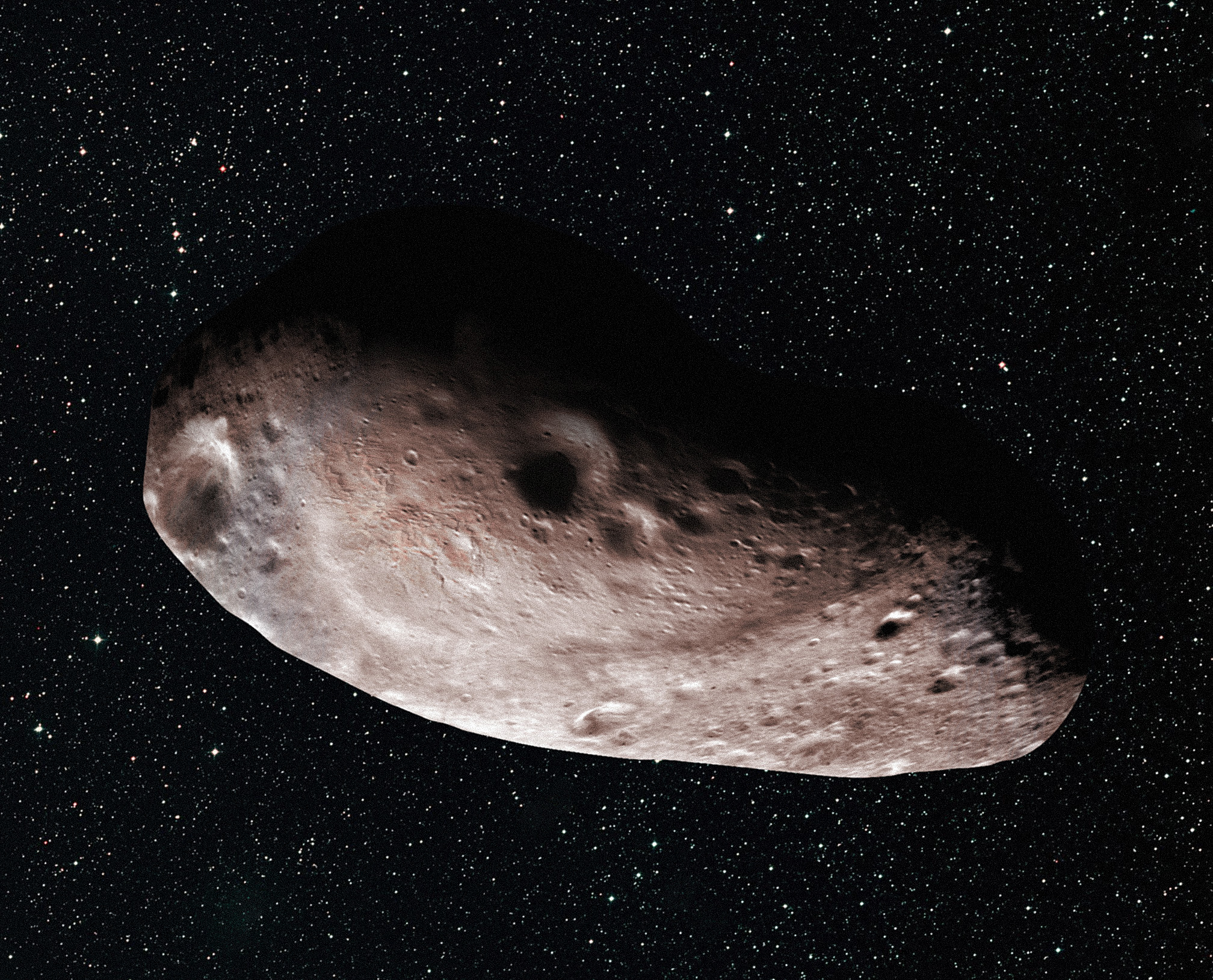
In the past, NASA believed this object was a spherical chunk of ice and rock measuring 18–41 km (10–30 mi) in diameter. However, a more recent occultation observation has led the New Horizon‘s team to conclude that MU69 may actually be a large object with a chunk taken out of it (an “extreme prolate spheroid”) or two objects orbiting very closely together or touching – aka. a close or contact binary.
In 2015, MU69 was identified as one of two potential destinations for New Horizons and was recommended to NASA by the mission science team. It was selected because of the immense opportunities for research it presented. As Alan Stern, the Principle Investigator (PI) for the New Horizons mission at the Southwest Research Institute (SwRI), indicated at the time:
“2014 MU69 is a great choice because it is just the kind of ancient KBO, formed where it orbits now, that the Decadal Survey desired us to fly by. Moreover, this KBO costs less fuel to reach [than other candidate targets], leaving more fuel for the flyby, for ancillary science, and greater fuel reserves to protect against the unforeseen.”
Artist’s concept of a binary object, which new data suggests 2014 MU69 (the next flyby target for NASA’s New Horizons mission) could be. Credits: NASA/JHUAPL/SwRI/Alex Parker
The most recent observation of the KBO took place on July 17th, 2017, when the object passed in front of a star. This provided the New Horizon’s team with an opportunity to measure the resulting dip in the star’s luminosity – aka. an occultation – using a series of telescopes that they had deployed to a remote part of Patagonia, Argentina. These sorts of observations are performed regularly in order to obtain estimates of an asteroid’s size and position.
In the case of MU69’s occulation, the New Horizons team was able to obtain vital data that will help the mission planners to plot the trajectory of their flyby. In addition, the data revealed things about MU69’s size, shape, orbit, and the environment that surrounds it. It was because of this that the team began to question earlier estimates on the object’s size and shape.
Based on their new observations, they are confident that the object is no more than 30 km (20 mi) long, if it is an extreme prolate spheroid. If, however, it is a binary, the two objects that compose it are believed to measure about 15-20 km (9-12 mi) in diameter each. Alan Stern expanded on these new findings in a recent NASA press statement, saying:
“This new finding is simply spectacular. The shape of MU69 is truly provocative, and could mean another first for New Horizons going to a binary object in the Kuiper Belt. I could not be happier with the occultation results, which promise a scientific bonanza for the flyby.”
Artist’s concept of Kuiper Belt object 2014 MU69 as a single body (above) with a large chunk taken out of it. Credits: NASA/JHUAPL/SwRI/Alex Parker
The recent stellar occulation was the third of three observations conducted for the New Horizons mission. To prepare for the event, the New Horizons team traveled to Argentina and South Africa on June 3rd. On July 10th, a week before the occultation, NASA’s airborne Stratospheric Observatory for Infrared Astronomy (SOFIA) provided support by studying the space around MU69.
Using its 2.5 m (100-inch) telescope, SOFIA was looking for debris that might present a hazard to New Horizons spacecraft as it makes its flyby less than 17 months from now. Last, but certainly not least, the team also relied on data provided by NASA’s Hubble Space Telescope and the ESA’s Gaia satellite to calculate and pinpoint where MU69 would cast its shadow on Earth’s surface.
Thanks to their assistance, the New Horizons team knew exactly where the occultation shadow would be and set up their “fence line” of small, mobile telescopes accordingly. Marc Buie – the New Horizons co-investigator – was responsible for leading the observation campaign. As he explained, the data it yielded will be of great help in the planning the flyby, but also indicated that their could be some surprises in the future:
“These exciting and puzzling results have already been key for our mission planning,” he said, “but also add to the mysteries surrounding this target leading into the New Horizons encounter with MU69, now less than 17 months away.”
The flyby with MU69 is scheduled to take place on Jan. 1st, 2019, and will be the most distant flyby in the history of space exploration. In addition to being 1.6 billion km (1 billion mi) from Pluto, the New Horizons spacecraft will be 6.5 billion km (4 billion mi) from Earth! What’s more, the first-ever study of a KBO is expected to yield some fantastic scientific data, and tell us much about the formation and evolution of our Solar System.
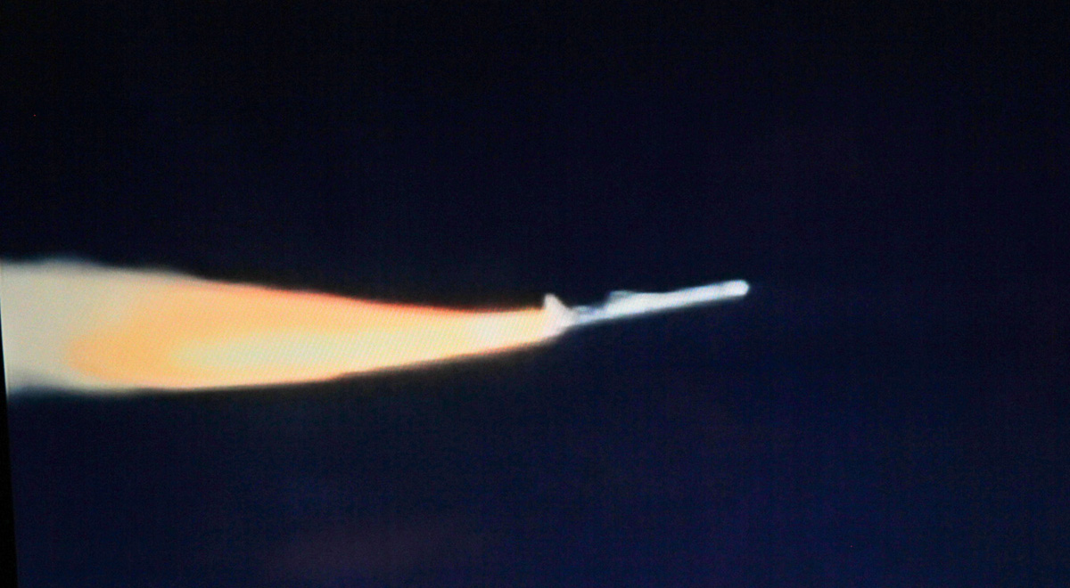
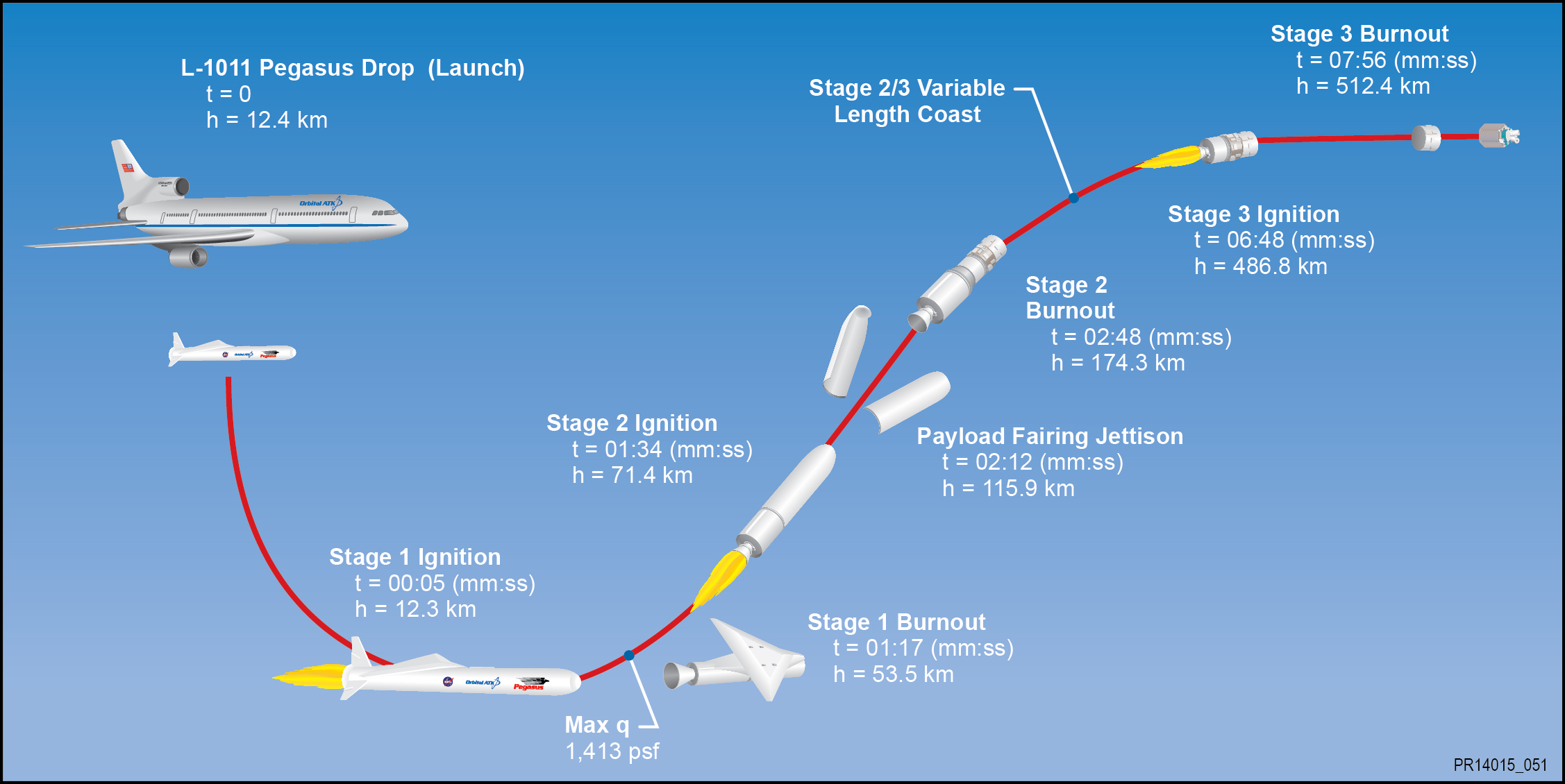
Launch of the Orbital ATK Pegasus XL rocket carrying NASA’s CYGNSS spacecraft at 8:37 a.m. EST on Dec. 15, 2016. Credit: NASA TV/Ken Kremer
Launch of the Orbital ATK Pegasus XL rocket carrying NASA’s CYGNSS spacecraft at 8:37 a.m. EST on Dec. 15, 2016. Credit: NASA TV/Ken Kremer
KENNEDY SPACE CENTER, FL – NASA’s constellation of experimental hurricane monitoring CYGNSS microsatellites was successfully air launched by the unique Orbital ATK winged Pegasus rocket on Thursday, Dec 15 – opening a new era in weather forecasters ability to measure the buildup of hurricane intensity in the tropics from orbit that will eventually help save lives and property from impending destructive storms here on Earth.
The agency’s innovative Cyclone Global Navigation Satellite System (CYGNSS) earth science mission was launched at 8:37 a.m. EST, Dec. 15, aboard a commercially developed Orbital ATK Pegasus XL rocket from a designated point over the Atlantic Ocean off the east coast of Florida.
Officials just announced this morning Dec. 16 that the entire fleet is operating well.
“NASA confirmed Friday morning that all eight spacecraft of its latest Earth science mission are in good shape.”
“The launch of CYGNSS is a first for NASA and for the scientific community,” said Thomas Zurbuchen, associate administrator for the agency’s Science Mission Directorate in Washington.
“As the first orbital mission in our Earth Venture program, CYGNSS will make unprecedented measurements in the most violent, dynamic, and important portions of tropical storms and hurricanes.”
An Orbital ATK L-1011 “Stargazer” aircraft carrying a Pegasus XL rocket with NASA’s CYGNSS spacecraft takes off from the Skid Strip at Cape Canaveral Air Force Station, Florida on Dec. 15, 2016 and successfully launches the spacecraft. Credit: Ken Kremer/kenkremer.com
Late Thursday, NASA announced that contact had been made with the entire fleet of eight small satellites after they had been successfully deployed and safely delivered to their intended position in low Earth orbit.
“We have successfully contacted each of the 8 observatories on our first attempt,” announced Chris Ruf, CYGNSS principal investigator with the Department of Climate and Space Sciences and Engineering at the University of Michigan.
“This bodes very well for their health and “status, which is the next thing we will be carefully checking with the next contacts in the coming days.”
The three stage Pegasus XL rocket housing the CYGNSS earth science payload inside the payload fairing had been carried aloft to 39,000 feet by an Orbital ATK L-1011 Tristar and dropped from the aircrafts belly for an air launch over the Atlantic Ocean and about 110 nautical miles east-northeast of Daytona Beach.
The Orbital ATK Pegasus XL rocket with NASA’s CYGNSS hurricane observing microsatellites is attached to the belly of the Stargazer L-1011 as technicians work at the Skid Strip at Cape Canaveral Air Force Station in Florida. It launched the payload to orbit on Dec. 15, 2016. Credit: Ken Kremer/kenkremer.com
The L-1011 nicknamed Stargazer took off at about 7:30 a.m. EST from NASA’s Skid Strip on Cape Canaveral Air Force Station in Florida as the media including myself watched the events unfold under near perfect Sunshine State weather with brilliantly clear blue skies.
After flying to the dropbox point – measuring about 40-miles by 10-miles (64-kilometers by 16-kilometers) – the Pegasus rocket was dropped from the belly, on command by the pilot, for a short freefall of about 5 seconds to initiate the launch sequence and engine ignition.
Pegasus launches horizontally in midair with ignition of the first stage engine burn, and then tilts up to space to begin the approximate ten minute trek to LEO.
The rocket launch and satellite release when exactly as planned with no hiccups.
It’s a beautiful day, with gorgeous weather,” said NASA CYGNSS launch director Tim Dunn. “We had a nominal flyout, and all three stages performed beautifully. We had no issues at all with launch vehicle performance.”
Deployment of the first pair of CYGNSS satellites in the eight satellite fleet started just 13 minutes after launch. The other six followed sequentially staged some 30 seconds apart.
“It’s a great event when you have a successful spacecraft separation – and with eight microsatellites, you get to multiply that times eight,” Dunn added.
“The deployments looked great — right on time,” said John Scherrer, CYGNSS Project Manager at the Southwest Research Institute and today’s CYGNSS mission manager, soon after launch.
“We think everything looks really, really good. About three hours after launch we’ll attempt first contact, and after that, we’ll go through a series of four contacts where we hit two [observatories] each time, checking the health and status of each spacecraft,” Scherrer added several prior to contact..
CYGNSS small satellite constellation launch came after a few days postponement due to technical issues following an aborted attempt on Monday, when the release mechanism failed and satellite parameter issues cropped up on Tuesday, both of which were rectified.
NASA’s innovative Cyclone Global Navigation Satellite System (CYGNSS) mission is expected to revolutionize hurricane forecasting by measuring the intensity buildup for the first time.
“The CYGNSS constellation consists of eight microsatellite observatories that will measure surface winds in and near a hurricane’s inner core, including regions beneath the eyewall and intense inner rainbands that previously could not be measured from space,” according to a NASA factsheet.
CYGNSS is an experimental mission to demonstrate proof-of-concept that could eventually turn operational in a future follow-up mission if the resulting data returns turn out as well as the researchers hope.
The CYGNSS constellation of 8 identical satellites works in coordination with the Global Positioning System (GPS) satellite constellation.
The eight satellite CYGNSS fleet “will team up with the Global Positioning System (GPS) constellation to measure wind speeds over Earth’s oceans and air-sea interactions, information expected to help scientists better understand tropical cyclones, ultimately leading to improved hurricane intensity forecasts.”
They will receive direct and reflected signals from GPS satellites.
“The direct signals pinpoint CYGNSS observatory positions, while the reflected signals respond to ocean surface roughness, from which wind speed is retrieved.”
This schematic outlines the key launch events:
Schematic of Orbital ATK L-1011 aircraft and Pegasus XL rocket air drop launch of NASA’s CYGNSS microsatellite fleet. Credit: Orbital ATK
The $157 million fleet of eight identical spacecraft comprising the Cyclone Global Navigation Satellite System (CYGNSS) system were all delivered to low Earth orbit by the Orbital ATK Pegasus XL rocket.
The nominal mission lifetime for CYGNSS is two years but the team says they could potentially last as long as five years or more if the spacecraft continue functioning.
Artist’s concept of the deployment of the eight Cyclone Global Navigation Satellite System (CYGNSS) microsatellite observatories in space. Credits: NASA
Pegasus launches from the Florida Space Coast are infrequent. The last once took place over 13 years ago in late April 2003 for the GALEX mission.
Typically they take place from Vandenberg Air Force Base in California or the Reagan Test Range on the Kwajalein Atoll.
An Orbital ATK L-1011 “Stargazer” aircraft carrying a Pegasus XL rocket with NASA’s CYGNSS spacecraft takes off from the Skid Strip at Cape Canaveral Air Force Station, Florida on Dec. 12, 2016. Credit: Ken Kremer/kenkremer.com
CYGNSS counts as the 20th Pegasus mission for NASA and the 43rd mission overall for Orbital ATK.
The CYGNSS spacecraft were built by Southwest Research Institute in San Antonio, Texas.
The solar panels and spacecraft dispenser were built by Sierra Nevada Corporation (SNC).
Each one weighs approx 29 kg. The deployed solar panels measure 1.65 meters in length.
The solar panels measure 5 feet in length and will be deployed within about 15 minutes of launch.
“We are thrilled to be a part of a project that helps gain better hurricane data that can eventually help keep a lot of people safe, but from a business side, we are also glad we could help SwRI achieve their mission requirements with better performance and lower cost and risk,” said Bryan Helgesen, director of strategy and business development for Space Technologies in SNC’s Space Systems business area, in a statement.
Rear view into the first stage engine of Orbital ATK Pegasus XL rocket that will launch NASA’s CYGNSS experimental hurricane observation payload on Dec. 14, 2016. They are mated to the bottom of the Orbital ATK L-1011 Stargazer aircraft at the Skid Strip at Cape Canaveral Air Force Station in Florida. Credit: Ken Kremer/kenkremer.com
The Space Physics Research Laboratory at the University of Michigan College of Engineering in Ann Arbor leads overall mission execution in partnership with the Southwest Research Institute in San Antonio, Texas.
The Climate and Space Sciences and Engineering Department at the University of Michigan leads the science investigation, and the Earth Science Division of NASA’s Science Mission Directorate oversees the mission.
The Orbital ATK L-1011 Stargazer aircraft at the Skid Strip at Cape Canaveral Air Force Station in Florida. Attached beneath the Stargazer is the Orbital ATK Pegasus XL with NASA’s CYGNSS payload on board, being processed for launch on Dec. 12, 2016. Credit: Ken Kremer/kenkremer.com
Stay tuned here for Ken’s continuing Earth and Planetary science and human spaceflight news.
An Orbital ATK technician checks the installation of two of the eight the CYGNSS microsatellites on their deployment module at Vandenberg Air Force Base in California. Credits: Photo credit: USAF
………….
Learn more about ULA Atlas V EchoStar 19 comsat launch, GOES-R launch, Heroes and Legends at KSCVC, OSIRIS-REx, InSight Mars lander, ULA, SpaceX and Orbital ATK missions, Juno at Jupiter, SpaceX AMOS-6 & CRS-9 rocket launch, ISS, ULA Atlas and Delta rockets, Orbital ATK Cygnus, Boeing, Space Taxis, Mars rovers, Orion, SLS, Antares, NASA missions and more at Ken’s upcoming outreach events:
Dec. 16-18: “ULA Atlas V EchoStar 19 comsat launch,GOES-R weather satellite launch, OSIRIS-Rex, SpaceX and Orbital ATK missions to the ISS, Juno at Jupiter, ULA Delta 4 Heavy spy satellite, SLS, Orion, Commercial crew, Curiosity explores Mars, Pluto and more,” Kennedy Space Center Quality Inn, Titusville, FL, evenings
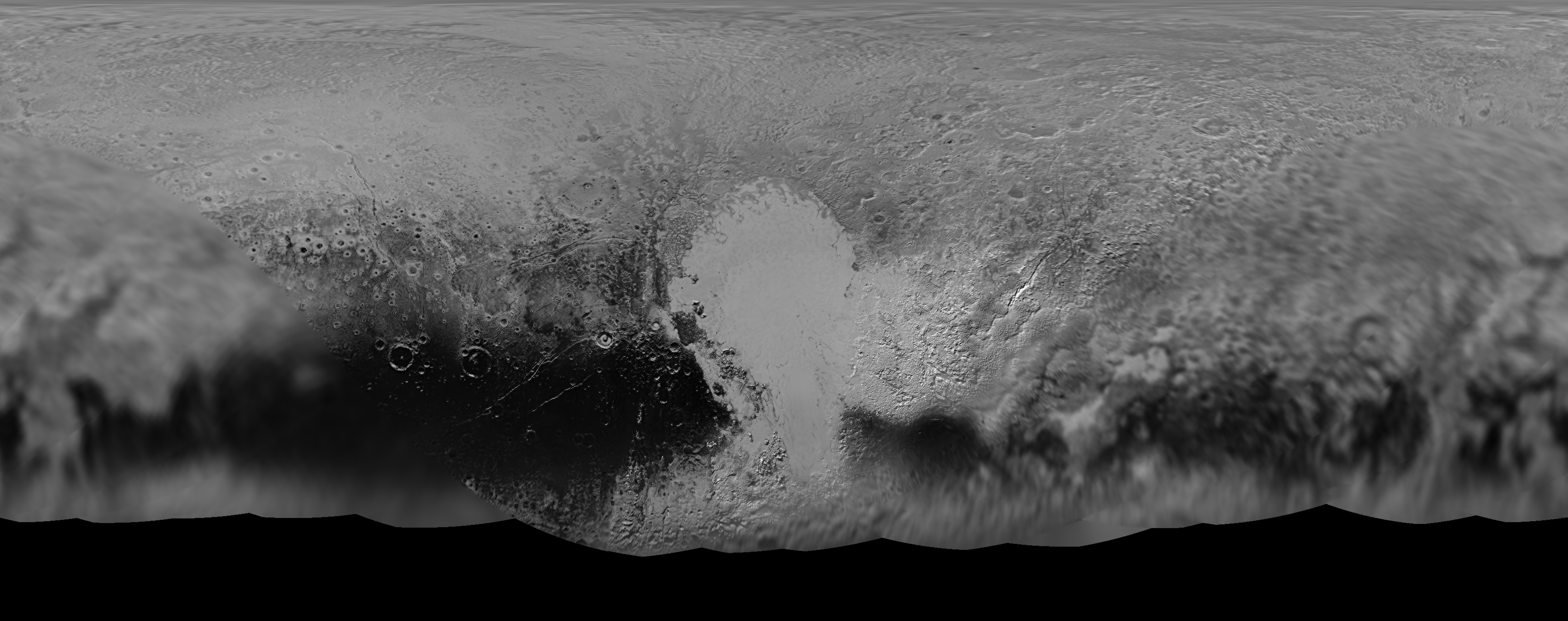
NASA’s New Horizons mission science team has produced this updated panchromatic (black-and-white) global map of Pluto. Credits: NASA/JHUAPL/SWRI
NASA’s New Horizons mission science team has produced this updated panchromatic (black-and-white) global map of Pluto. Credits: NASA/JHUAPL/SWRI
The science team leading NASA’s New Horizons mission that unveiled the true nature of Pluto’s long hidden looks during the history making maiden close encounter last July, have published a fresh global map that offers the sharpest and most spectacular glimpse yet of the mysterious, icy world.
The newly updated global Pluto map is comprised of all the highest resolution images transmitted back to Earth thus far and provides the best perspective to date.
Click on the lead image above to enjoy Pluto revealed at its finest thus far. Click on this link to view the highest resolution version.
Prior to the our first ever flyby of the Pluto planetary system barely 8 months ago, the planet was nothing more than a fuzzy blob with very little in the way of identifiable surface features – even in the most powerful telescopic views lovingly obtained from the Hubble Space Telescope (HST).
Dead center in the new map is the mesmerizing heart shaped region informally known as Tombaugh Regio, unveiled in all its glory and dominating the diminutive world.
The panchromatic (black-and-white) global map of Pluto published by the team includes the latest images received as of less than one week ago on April 25.
The images were captured by New Horizons’ high resolution Long Range Reconnaissance Imager (LORRI).
The science team is working on assembling an updated color map.
During its closest approach at approximately 7:49 a.m. EDT (11:49 UTC) on July 14, 2015, the New Horizons spacecraft swoop to within about 12,500 kilometers (nearly 7,750 miles) of Pluto’s surface and about 17,900 miles (28,800 kilometers) from Charon, the largest moon.
The map includes all resolved images of Pluto’s surface acquired in the final week of the approach period ahead of the flyby starting on July 7, and continuing through to the day of closest approach on July 14, 2015 – and transmitted back so far.
The pixel resolutions are easily seen to vary widely across the map as you scan the global map from left to right – depending on which Plutonian hemisphere was closest to the spacecraft during the period of close flyby.
They range from the highest resolution of 770 feet (235 meters), at center, to 18 miles (30 kilometers) at the far left and right edges.
The Charon-facing hemisphere (left and right edges of the map) had a pixel resolution of 18 miles (30 kilometers).
“This non-encounter hemisphere was seen from much greater range and is, therefore, in far less detail,” noted the team.
However the hemisphere facing New Horizons during the spacecraft’s closest approach on July 14, 2015 (map center) had a far higher pixel resolution reaching to 770 feet (235 meters).
Coincidentally and fortuitously the spectacularly diverse terrain of Tombaugh Regio and the Sputnik Planum area of the hearts left ventricle with ice flows and volcanoes, mountains and river channels was in the region facing the camera and sports the highest resolution imagery.
See below a newly released shaded relief map of Sputnik Planum.
This new shaded relief view of the region surrounding the left side of Pluto’s heart-shaped feature – informally named Sputnik Planum – shows that the vast expanse of the icy surface is on average 2 miles (3 kilometers) lower than the surrounding terrain. Angular blocks of water ice are “floating” in the bright deposits of softer, denser solid nitrogen. Credits: NASA/JHUAPL/SwRI
“Sputnik Planum – shows that the vast expanse of the icy surface is on average 2 miles (3 kilometers) lower than the surrounding terrain. Angular blocks of water ice along the western edge of Sputnik Planum can be seen “floating” in the bright deposits of softer, denser solid nitrogen,” according to the team.
Even more stunning images and groundbreaking data will continue streaming back from New Horizons until early fall, across over 3 billion miles of interplanetary space.
Thus the global map of Pluto will be periodically updated.
Its taking over a year to receive the full complement of some 50 gigabits of data due to the limited bandwidth available from the transmitter on the piano-shaped probe as it hurtled past Pluto, its largest moon Charon and four smaller moons.
Pluto is the last planet in our solar system to be visited in the initial reconnaissance of planets by spacecraft from Earth since the dawn of the Space Age.
This new global mosaic view of Pluto was created from the latest high-resolution images to be downlinked from NASA’s New Horizons spacecraft and released on Sept. 11, 2015. The images were taken as New Horizons flew past Pluto on July 14, 2015, from a distance of 50,000 miles (80,000 kilometers). This new mosaic was stitched from over two dozen raw images captured by the LORRI imager and colorized. Annotated with informal place names. Credits: NASA/Johns Hopkins University Applied Physics Laboratory/Southwest Research Institute/Marco Di Lorenzo/Ken Kremer/kenkremer.com
New Horizons remains on target to fly by a second Kuiper Belt Object (KBO) on Jan. 1, 2019 – tentatively named PT1, for Potential Target 1. It is much smaller than Pluto and was recently selected based on images taken by NASA’s Hubble Space Telescope.
Stay tuned here for Ken’s continuing Earth and planetary science and human spaceflight news.
Lucy, an SwRI mission proposal to study primitive asteroids orbiting near Jupiter, is one of five science investigations under the NASA Discovery Program up for possible funding. Credit: swri.org
In February of 2014, NASA’s Discovery Program put out the call for mission proposals, one or two of which will have the honor of taking part in Discovery Mission Thirteen. Hoping to focus the next round of exploration efforts to places other than Mars, the five semifinalists (which were announced this past September) include proposed missions to Venus, Near-Earth Objects, and asteroids.
When it comes to asteroid exploration, one of the possible contenders is Lucy – a proposed reconnaissance orbiter that would study Jupiter‘s Trojan Asteroids. In addition to being the first mission of its kind, examining the Trojans Asteroids could also lead to several scientific finds that will help us to better understand the history of the Solar System.
By definition, Trojan are populations of asteroids that share their orbit with other planets or moons, but do not collide with it because they orbit in one of the two Lagrangian points of stability. The most significant population of Trojans in the Solar System are Jupiter’s, with a total of 6,178 having been found as of January 2015. In accordance with astronomical conventions, objects found in this population are named after mythical figures from the Trojan War.
There are two main theories as to where Jupiter’s Trojans came from. The first suggests that they formed in the same part of the Solar System as Jupiter and were caught by the gas giant’s gravity as it accumulated hydrogen and helium from the protoplanetary disk. Since they would have shared the same approximate orbit as the forming gas giant, they would have been caught in its gravity and orbited it ever since.
The asteroids of the Inner Solar System and Jupiter. Credit: Wikipedia Commons
The second theory, part of the Nice model, proposes that the Jupiter Trojans were captured about 500-600 million years after the Solar System’s formation. During this period Uranus, Neptune – and to a lesser extent, Saturn – moved outward, whereas Jupiter moved slightly inward. This migration could have destabilized the primordial Kuiper Belt, throwing millions of objects into the inner Solar System, some of which Jupiter then captured.
In either case, the presence of Trojan asteroids around Jupiter can be traced back to the early Solar System. Studying them therefore presents an opportunity to learn more about its history and formation. And if in fact the Trojans are migrant from the Kuiper Belt, it would also be a chance for scientists to learn more about the most distant reaches of the solar system without having to send a mission all the way out there.
The mission would be led by Harold Levison of the Southwest Research Institute (SwRI) in Boulder, Colorado, with the Goddard Space Center managing the project. Its targets would most likely include asteroid (3548) Eurybates, (21900) 1999 VQ10, (11351) 1997 TS25, and the binary (617) Patroclus/Menoetius. It would also visit a main-belt asteroid (1981 EQ5) on the way.
The spacecraft would perform scans of the asteroids and determine their geology, surface features, compositions, masses and densities using a sophisticated suite of remote-sensing and radio instruments. In addition, during it’s proposed 11-year mission, Lucy would also gather information on the asteroids thermal and other physical properties from close range.
Artist’s concept of Jupiter’s Trojan asteroids hovering in the foreground in Jupiter’s path, with the “Greeks” at left in the background. Credit: NASA.
The project is named Lucy in honor of one of the most influential human fossils found on Earth. Discovered in the Awash Valley of Ethiopia in 1974, Lucy’s remains – several hundred bone fragments that belonged to a member the hominid species of Australopithecus afarensis – proved to be an extraordinary find that advanced our knowledge of hominid species evolution.
Levison and his team are hoping that a similar find can be made using the probe of the same name. As he and his colleagues describe it, the Lucy mission is aimed at “Surveying the diversity of Trojan asteroids: The fossils of planet formation.”
“This is a once-in-a-lifetime opportunity,” said Levinson. “Because the Trojan asteroids are remnants of that primordial material, they hold vital clues to deciphering the history of the solar system. These asteroids are in an area that really is the last population of objects in the solar system to be visited.”
The payload is expected to include three complementary imaging and mapping instruments, including a color imaging and infrared mapping spectrometer, a high-resolution visible imager, and a thermal infrared spectrometer. NASA has also offered an additional $5 to $30 million in funding if mission planners choose to incorporate a laser communications system, a 3D woven heat shield, a Deep Space atomic clock, and/or ion engines.
As one of the semifinalists, the Lucy mission has received $3 million dollars to conduct concept design studies and analyses over the course of the next year. After a detailed review and evaluation of the concept studies, NASA will make the final selections by September 2016. In the end, one or two missions will receive the mission’s budget of $450 million (not including launch vehicle funding or post-launch operations) and will be launched by 2020 at the earliest.
This color image of Pluto taken by NASA’s New Horizons spacecraft shows rounded and bizarrely textured mountains, informally named the Tartarus Dorsa, rise up along Pluto’s terminator and show intricate but puzzling patterns of blue-gray ridges and reddish material in between. This view, roughly 330 miles (530 kilometers) across, combines blue, red and infrared images taken by the Ralph/Multispectral Visual Imaging Camera (MVIC) on July 14, 2015, and resolves details and colors on scales as small as 0.8 miles (1.3 kilometers). Credits: NASA/JHUAPL/SWRI
Data from that priceless, once in a lifetime flyby is now trickling back to Earth.
The ‘snakeskin’ feature on Pluto’s utterly bizarre surface was unveiled to “astonished” scientists scrutinizing the latest data dump received over the past week, that included images taken by the Ralph instruments Multispectral Visual Imaging Camera (MVIC).
Features as small as 0.8 miles (1.3 kilometers) are resolved in detail.
The MVIC image stretches about 330 miles (530 kilometers) across the ‘snakeskin’ like landscape composed of rounded and bizarrely textured mountains that are informally named Tartarus Dorsa and that borders the bodies day-night terminator.
It shows intricate patterns of blue-gray ridges and reddish material in between that are puzzling researchers.
“It’s a unique and perplexing landscape stretching over hundreds of miles,” said William McKinnon, New Horizons Geology, Geophysics and Imaging (GGI) team deputy lead from Washington University in St. Louis.
“It looks more like tree bark or dragon scales than geology. This’ll really take time to figure out; maybe it’s some combination of internal tectonic forces and ice sublimation driven by Pluto’s faint sunlight.”
The Ralph/MVIC image is actually a composite of blue, red and infrared images.
The image of Tartarus Dorsa reveals a “multitude of previously unseen topographic and compositional details. It captures a vast rippling landscape of strange, aligned linear ridges that has astonished New Horizons team members,” say officials.
NASA’s New Horizons spacecraft captured this high-resolution enhanced color view of Pluto on July 14, 2015. The image combines blue, red and infrared images taken by the Ralph/Multispectral Visual Imaging Camera (MVIC). Pluto’s surface sports a remarkable range of subtle colors, enhanced in this view to a rainbow of pale blues, yellows, oranges, and deep reds. Many landforms have their own distinct colors, telling a complex geological and climatological story that scientists have only just begun to decode. The image resolves details and colors on scales as small as 0.8 miles (1.3 kilometers). The viewer is encouraged to zoom in on the image on a larger screen to fully appreciate the complexity of Pluto’s surface features. Credit: NASA/JHUAPL/SwRI
Another wider angle global view of Pluto downlinked on Sept. 19 shows a new “extended color” view of Pluto with an the extraordinarily rich color palette of the planet.
“We used MVIC’s infrared channel to extend our spectral view of Pluto,” said John Spencer, a GGI deputy lead from Southwest Research Institute (SwRI) in Boulder, Colorado.
“Pluto’s surface colors were enhanced in this view to reveal subtle details in a rainbow of pale blues, yellows, oranges, and deep reds. Many landforms have their own distinct colors, telling a wonderfully complex geological and climatological story that we have only just begun to decode.”
The image resolves details and colors on scales as small as 0.8 miles (1.3 kilometers).
High-resolution images of Pluto taken by NASA’s New Horizons spacecraft just before closest approach on July 14, 2015, reveal features as small as 270 yards (250 meters) across, from craters to faulted mountain blocks, to the textured surface of the vast basin informally called Sputnik Planum. Enhanced color has been added from the global color image. This image is about 330 miles (530 kilometers) across. For optimal viewing, zoom in on the image on a larger screen. Credits: NASA/JHUAPL/SWRI
Beyond MVIC, additional new images taken by New Horizons’ narrow-angle Long Range Reconnaissance Imager (LORRI) during the July 14 were downlinked on Sept. 20.
They focus on the Sputnik Planum ice plains on the left side of the famous heart shaped Tombaugh Regio feature and are the highest resolution yet – as seen below. The team added color based on the global MVIC map shown above.
High-resolution images of Pluto taken by NASA’s New Horizons spacecraft just before closest approach on July 14, 2015, are the sharpest images to date of Pluto’s varied terrain—revealing details down to scales of 270 meters. In this 75-mile (120-kilometer) section of the taken from a larger, high-resolution mosaic, the textured surface of the plain surrounds two isolated ice mountains. Credits: NASA/JHUAPL/SWRI
Barely 5 or 6 percent of the 50 gigabits of data captured by New Horizons has been received by ground stations back on Earth.
“With these just-downlinked images and maps, we’ve turned a new page in the study of Pluto beginning to reveal the planet at high resolution in both color and composition,” added New Horizons Principal Investigator Alan Stern, of SwRI.
“I wish Pluto’s discoverer Clyde Tombaugh had lived to see this day.”
Stern says it will take about a year for all the data to get back. Thus bountiful new discoveries are on tap.
This new global mosaic view of Pluto was created from the latest high-resolution images to be downlinked from NASA’s New Horizons spacecraft and released on Sept. 11, 2015. The images were taken as New Horizons flew past Pluto on July 14, 2015, from a distance of 50,000 miles (80,000 kilometers). This mosaic was stitched from over two dozen raw images captured by the LORRI imager and colorized. Right side mosaic comprises twelve highest resolution views of Tombaugh Regio heart shaped feature and shows objects as small as 0.5 miles (0.8 kilometers) in size. Credits: NASA/Johns Hopkins University Applied Physics Laboratory/Southwest Research Institute/ Ken Kremer/kenkremer.com/Marco Di Lorenzo
Stay tuned here for Ken’s continuing Earth and planetary science and human spaceflight news.
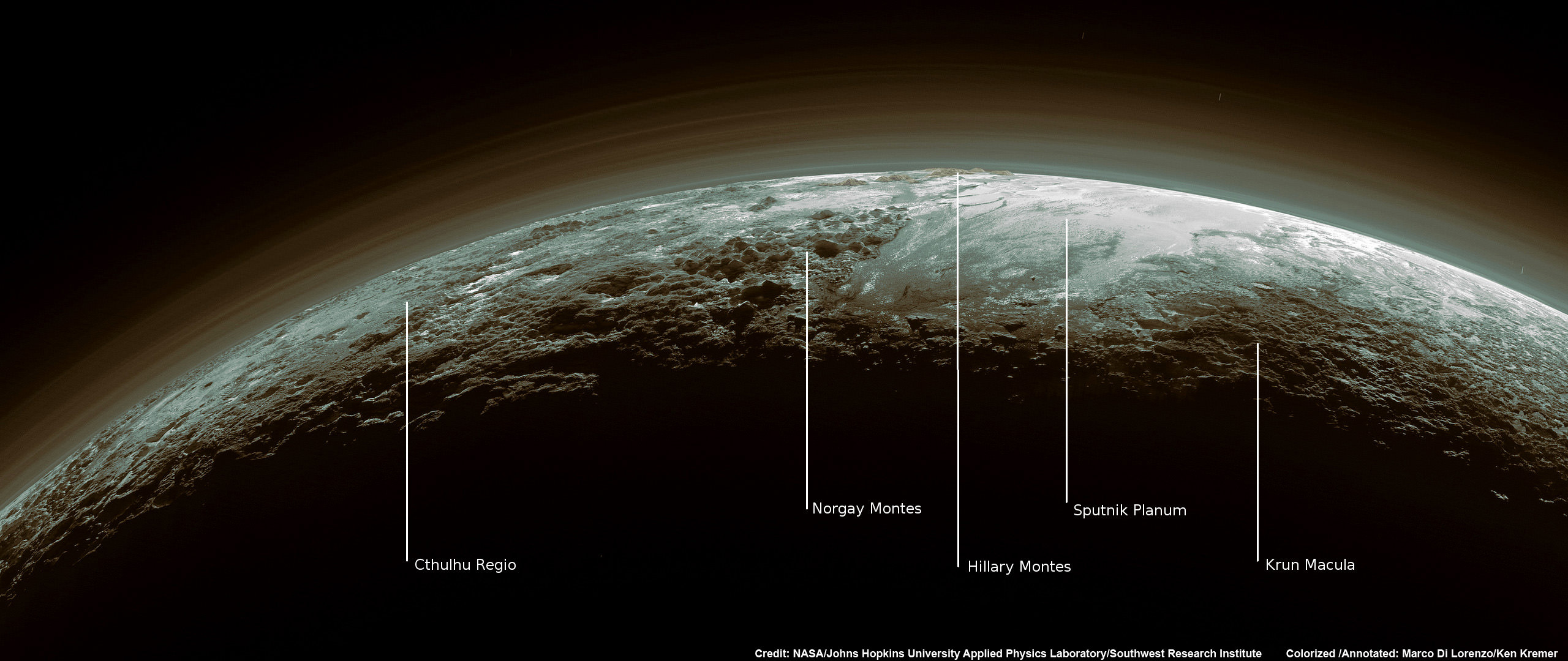
Just 15 minutes after its closest approach to Pluto on July 14, 2015, NASA’s New Horizons spacecraft looked back toward the sun and captured this near-sunset view of the rugged, icy mountains and flat ice plains extending to Pluto’s horizon – shown in this colorized rendition. The smooth expanse of the informally named icy plain Sputnik Planum (right) is flanked to the west (left) by rugged mountains up to 11,000 feet (3,500 meters) high, including the informally named Norgay Montes in the foreground and Hillary Montes on the skyline. To the right, east of Sputnik, rougher terrain is cut by apparent glaciers. The backlighting highlights more than a dozen layers of haze in Pluto’s tenuous but distended atmosphere. The image was taken from a distance of 11,000 miles (18,000 kilometers) to Pluto; the scene is 780 miles (1,250 kilometers) wide. Credit: NASA/Johns Hopkins University Applied Physics Laboratory/Southwest Research Institute. Colorized/Annotated: Marco Di Lorenzo/Ken Kremer/kenkremer.com


