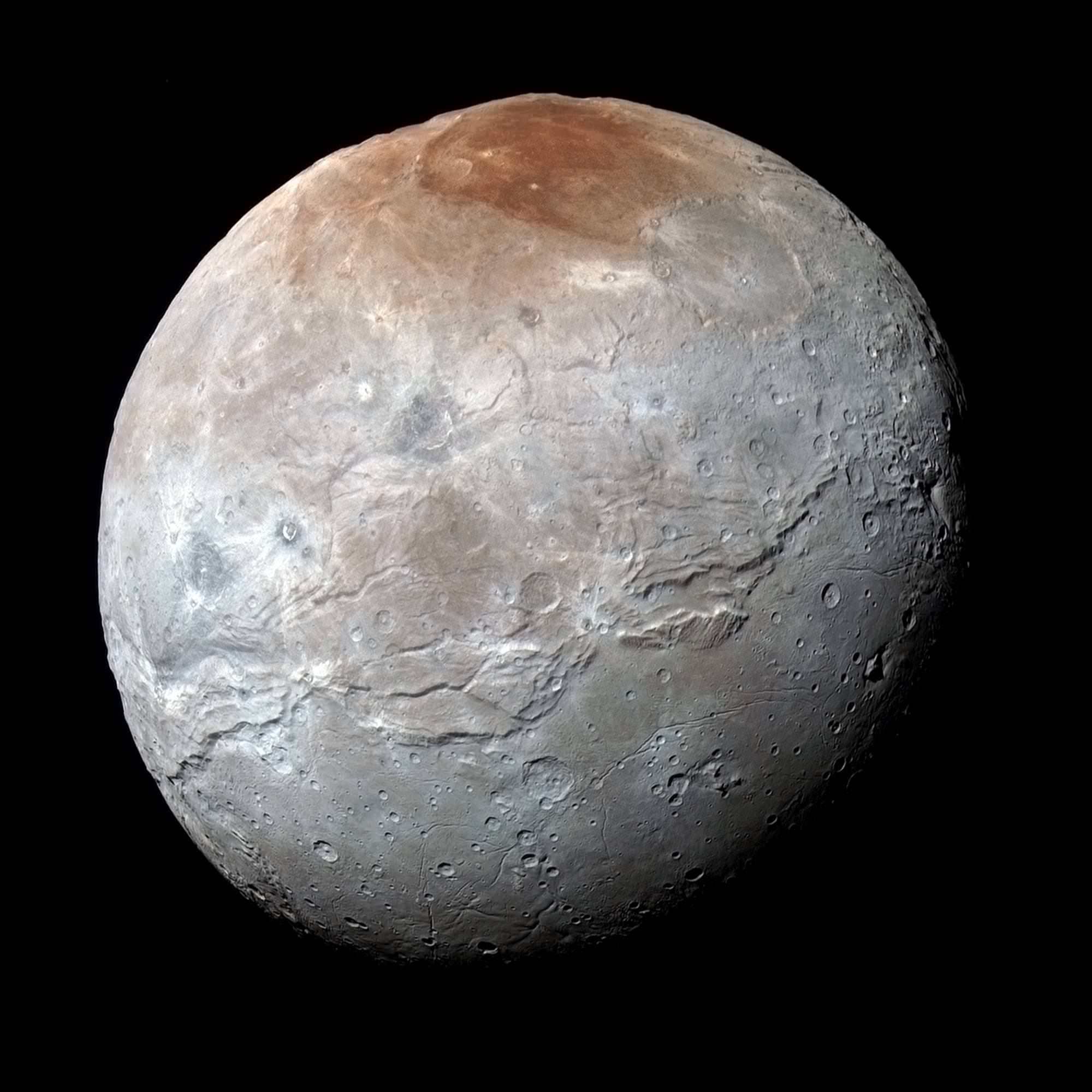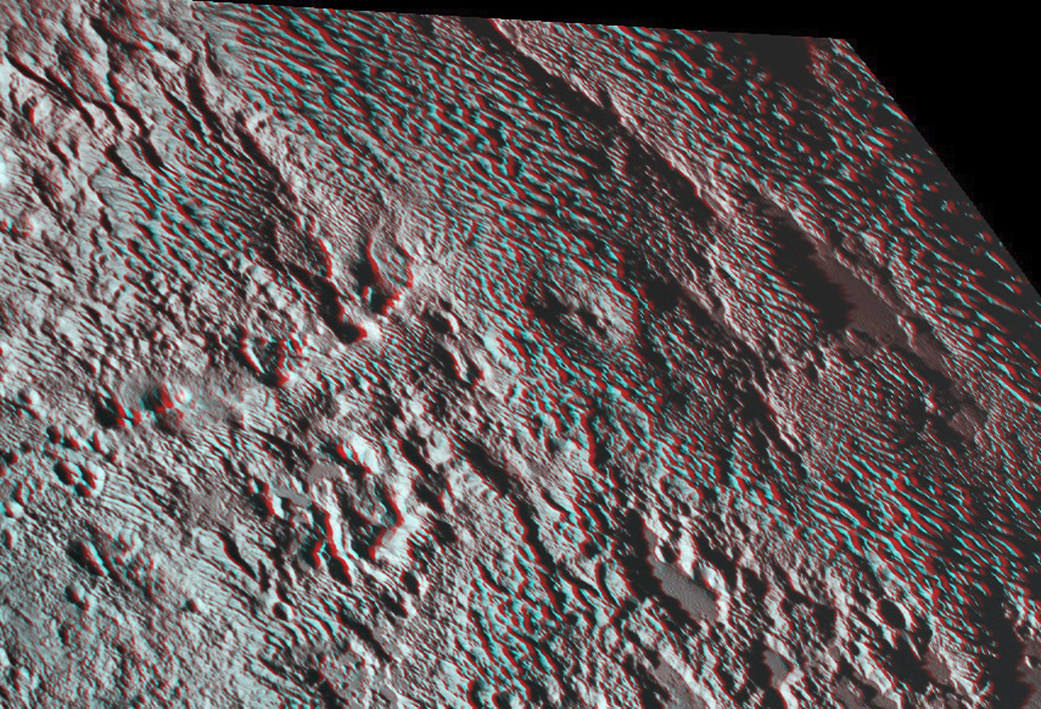
It’s time to whip out your 3-D glasses to enjoy and scrutinize the remarkable detail of spectacular terrain revealed in a new high resolution stereo image of Pluto – King of the Kuiper Belt! – taken by NASA’s New Horizons spacecraft.
The amazing new stereo Plutonian image focuses on an area dominated by a mysterious feature that geologists call ‘bladed’ terrain – seen above – and its unlike anything seen elsewhere in our solar system.
Its located in a broad region of rough highlands informally known as Tartarus Dorsa – situated to the east of the Pluto’s huge heart shaped feature called Tombaugh Regio. The best resolution is approximately 1,000 feet (310 meters).
The stereo view combines a pair of images captured by New Horizons Ralph/Multispectral Visible Imaging Camera (MVIC) science instruments. They were taken about 14 minutes apart on during history making first ever flyby of the Pluto planetary system on July 14, 2015.
The first was taken when New Horizons was 16,000 miles (25,000 kilometers) away from Pluto, the second when the spacecraft was 10,000 miles (about 17,000 kilometers) away.
The blades align from north to south, typically reach up to about 550 yards (500 meters) high and are spaced about 2-4 miles (3-5 kilometers). Thus they are among the planets steepest features. They are “perched on a much broader set of rounded ridges that are separated by flat valley floors,” according to descriptions from the New Horizons science team.

Mission scientists have also noted that the bladed terrain has the texture of “snakeskin” owing to their “scaly raised relief.”
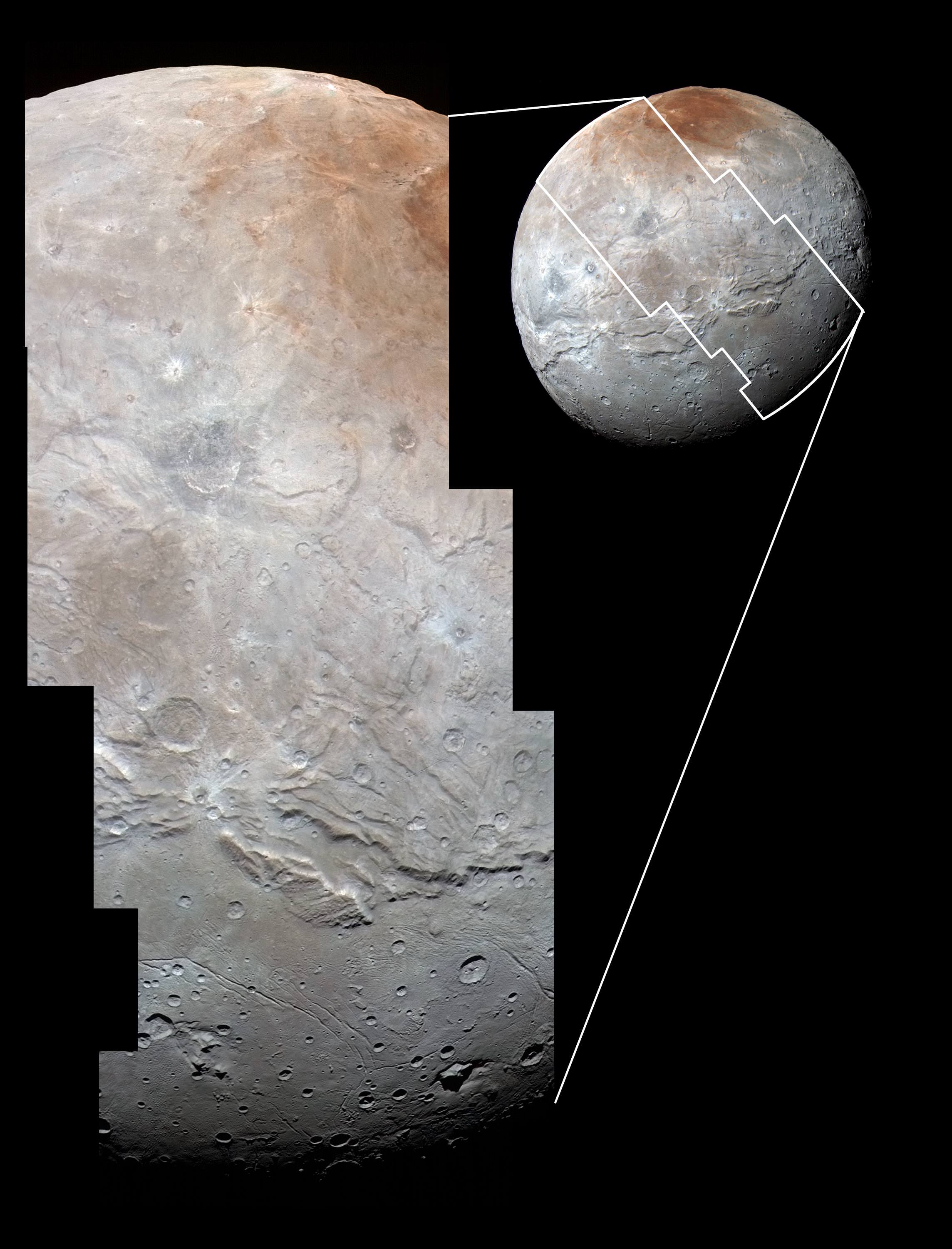
In the companion global image from NASA (below), the bladed terrain is outlined in red and shown to extend quite far to the east of Tombaugh Regio.
The composite image was taken on July 13, 2015, the day before the closest approach flyby, when the probe was farther away thus shows lower resolution. It combines a pair of images from two of the science instruments – a Ralph/Multispectral Visible Imaging Camera (MVIC) color scan and an image from the Long Range Reconnaissance Imager (LORRI).
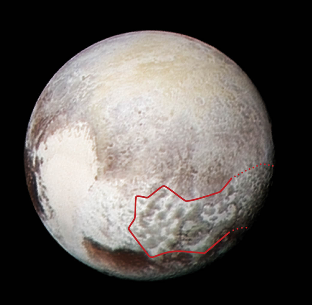
Credits: NASA/JHUAPL/SwRI
The MVIC scan was taken from a range of 1 million miles (1.6 million kilometers), at a resolution of 20 miles (32 kilometers) per pixel. The corresponding LORRI image was obtained from roughly the same range, but has a higher spatial resolution of 5 miles (8 kilometers) per pixel, say officials.
Scientists have developed several possible theories about the origins of the bladed terrain, including erosion from evaporating ices or deposition of methane ices.
Measurements from the Linear Etalon Imaging Spectral Array (LEISA) instrument reveal that that this region “is composed of methane (CH4) ice with a smattering of water,” reports New Horizons researcher Orkan Umurhan.
He speculates that “the material making up the bladed terrain is a methane clathrate. A clathrate is a structure in which a primary molecular species (say water, or H2O) forms a crystalline ‘cage’ to contain a guest molecule (methane or CH4, for example).”
But the question of whether that methane ice is strong enough to maintain the steep walled snakeskin features, will take much more research to determine a conclusive answer.
Umurhan suggests that more research could help determine if the “methane clathrates in the icy moons of the outer solar system and also in the Kuiper Belt were formed way back before the solar system formed – i.e., within the protosolar nebula – potentially making them probably some of the oldest materials in our solar system.”
Pluto continues to amaze and surprise us as the data streams back to eagerly waiting scientists on Earth over many more months to come – followed by years and decades of painstaking analysis.

During New Horizons flyby on July 14, 2015, it discovered that Pluto is the biggest object in the outer solar system and thus the ‘King of the Kuiper Belt.”
The Kuiper Belt comprises the third and outermost region of worlds in our solar system.
Pluto is the last planet in our solar system to be visited in the initial reconnaissance of planets by spacecraft from Earth since the dawn of the Space Age.
New Horizons remains on target to fly by a second Kuiper Belt Object (KBO) on Jan. 1, 2019 – tentatively named PT1, for Potential Target 1. It is much smaller than Pluto and was recently selected based on images taken by NASA’s Hubble Space Telescope.
Stay tuned here for Ken’s continuing Earth and planetary science and human spaceflight news.
………….
Learn more about NASA Mars rovers, Orion, SLS, ISS, Orbital ATK, ULA, SpaceX, Boeing, Space Taxis, NASA missions and more at Ken’s upcoming outreach events:
Apr 9/10: “NASA and the Road to Mars Human Spaceflight programs” and “Curiosity explores Mars” at NEAF (NorthEast Astronomy and Space Forum), 9 AM to 5 PM, Suffern, NY, Rockland Community College and Rockland Astronomy Club – http://rocklandastronomy.com/neaf.html
Apr 12: Hosting Dr. Jim Green, NASA, Director Planetary Science, for a Planetary sciences talk about “Ceres, Pluto and Planet X” at Princeton University; 7:30 PM, Amateur Astronomers Assoc of Princeton, Peyton Hall, Princeton, NJ – http://www.princetonastronomy.org/
Apr 17: “NASA and the Road to Mars Human Spaceflight programs”- 1:30 PM at Washington Crossing State Park, Nature Center, Titusville, NJ – http://www.state.nj.us/dep/parksandforests/parks/washcros.html