Sentinel-1A Satellite Takes A Direct Hit From Millimetre Size Particle

Sentinel-1 satellite, the first satellite to be launched as part of the ESA/EC's Copernicus program. Credit: ESA/ATG medialab

One of the worst things that can happen during an orbital mission is an impact. Near-Earth orbit is literally filled with debris and particulate matter that moves at very high speeds. At worst, a collision with even the smallest object can have catastrophic consequences. At best, it can delay a mission as technicians on the ground try to determine the damage and correct for it.

This was the case when, on August 23rd, the European Space Agency’s Sentinel-1A satellite was hit by a particle while it orbited the Earth. And after several days of reviewing the data from on-board cameras, ground controllers have determined what the culprit was, identified the affected area, and concluded that it has not interrupted the satellite’s operations.

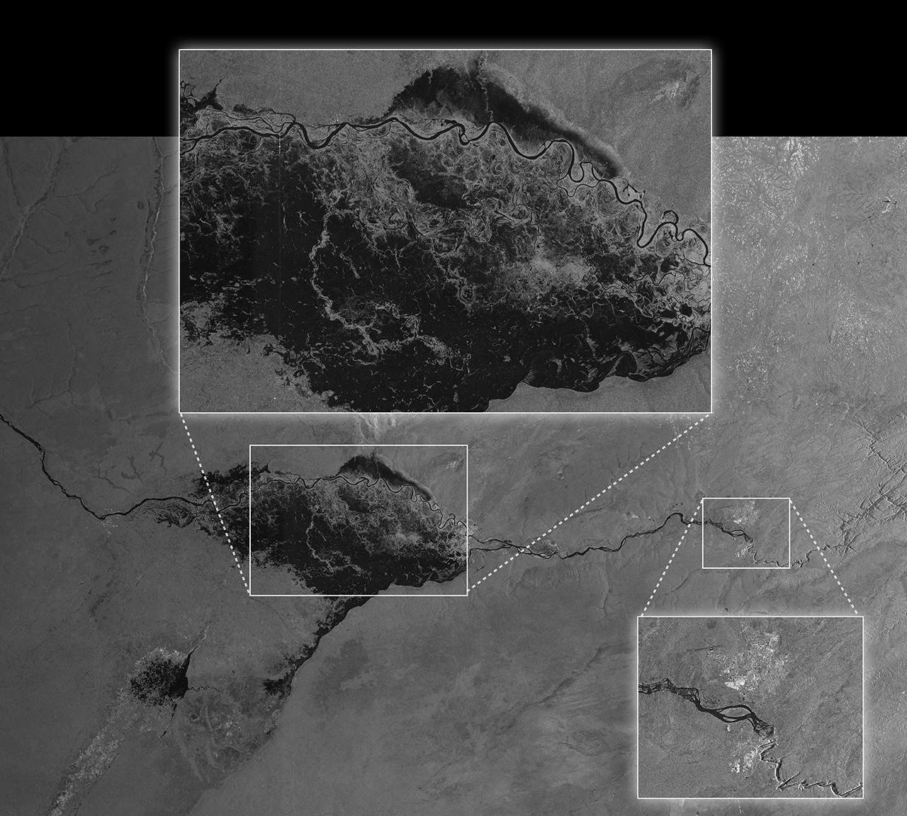
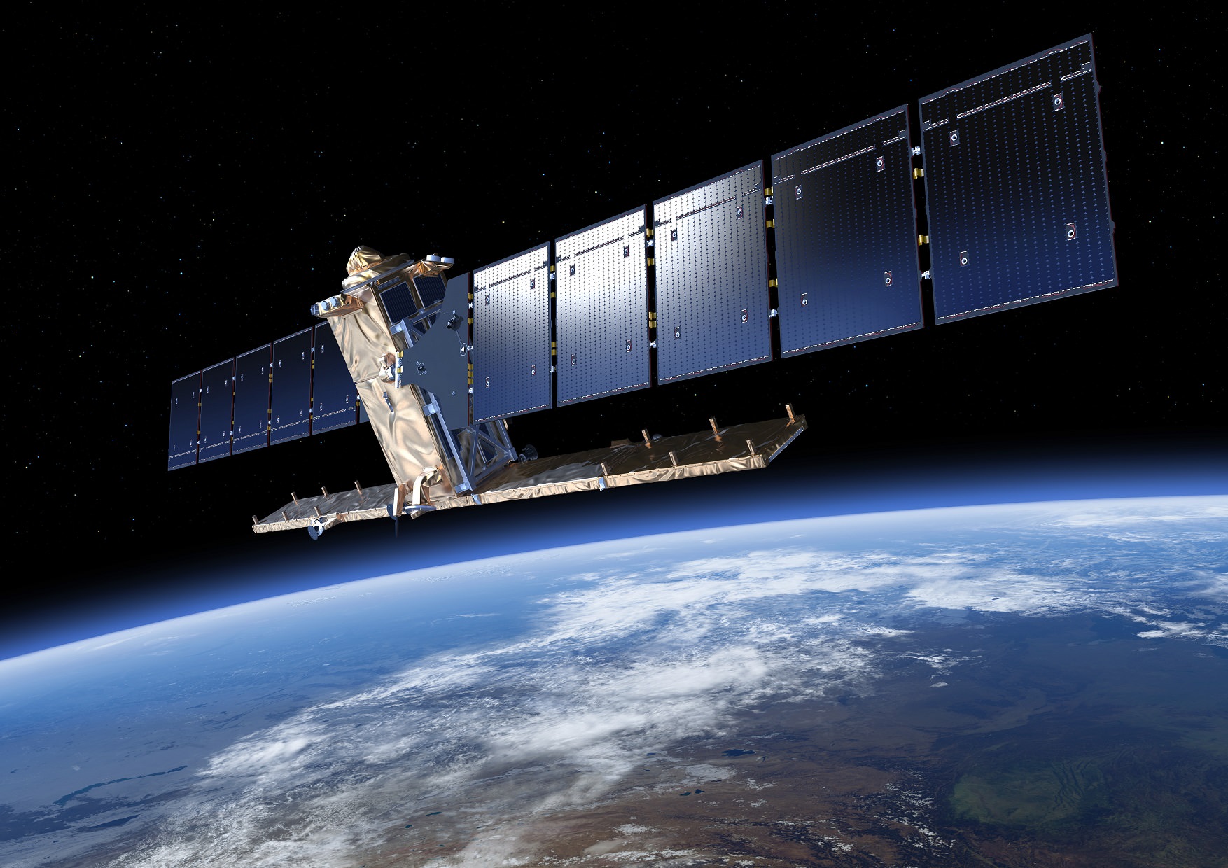
The Sentinel-1A mission was the first satellite to be launched as part of the ESA’s Copernicus program – which is the worlds largest single earth observation program to date. Since it was deployed in 2014, Sentinel-1A has been monitoring Earth using its C-band Synthetic Aperture Radar, which allows for crystal clear images regardless of weather or light conditions.

The picture shows Sentinel-1A’s solar array before and after the impact of a millimetre-size particle on the second panel. The damaged area has a diameter of about 40 cm, which is consistent on this structure with the impact of a fragment of less than 5 millimetres in size. Credit: ESA
Picturing obtained by one of the Sentinel-1A’s onboard cameras, showing the solar array before and after the impact of a millimeter-size particle on the second panel. Credit: ESA

In addition to tracking oil spills and mapping sea ice, the satellite has also been monitoring the movement of land surfaces. Recently, it provided invaluable insight into the earthquake in Italy that claimed at least 290 lives and caused widespread damage. These images were used by emergency aid organizations to assist in evacuations, and scientists have begun to analyze them for indications of how the quake occurred.

The first indication that something was wrong came on Tuesday, August 23rd, at 17:07 GMT (10:07 PDT, 13:07 EDT), when controllers noted a small power reduction. At the time, the satellite was at an altitude of 700 km, and slight changes in it’s orientation and orbit were also noticed.

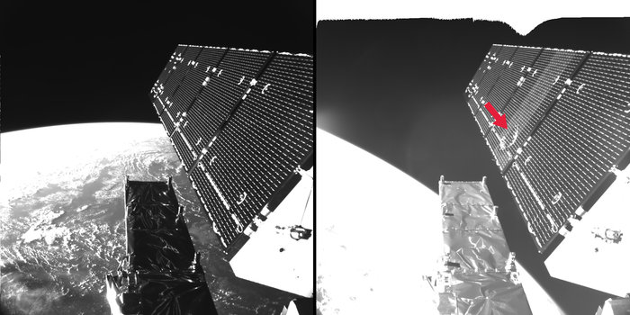
After conducting a preliminary investigation, the operations team at the ESA’s control center hypothesized that the satellite’s solar wing had suffered from an impact with a tiny object. After reviewing footage from the on-board cameras, they spotted a 40 cm hole in one of the solar panels, which was consistent with the impact of a fragment measuring less than 5 mm in size.

However, the power loss was not sufficient to interrupt operations, and the ESA was quick to allay fears that this would result in any interruptions of the Sentinel-1A‘s mission. They also indicated that the object’s small size prevented them from advanced warning.

Artist's impression of Sentinel-1A, showing its solar panels fully deployed. Credit and copyright: ESA–P. Carril, 2014
Artist’s impression of Sentinel-1A, showing its solar panels fully deployed. Credit and copyright: ESA–P. Carril, 2014

As Holger Krag – Head of the Space Debris Office at ESA’s establishment in Darmstadt, Germany – said in an agency press release:

“Such hits, caused by particles of millimeter size, are not unexpected. These very small objects are not trackable from the ground, because only objects greater than about 5 cm can usually be tracked and, thus, avoided by maneuvering the satellites. In this case, assuming the change in attitude and the orbit of the satellite at impact, the typical speed of such a fragment, plus additional parameters, our first estimates indicate that the size of the particle was of a few millimeters.

While it is not clear if the object came from a spent rocket or dead satellite, or was merely a tiny clump of rock, Krag indicated that they are determined to find out. “Analysis continues to obtain indications on whether the origin of the object was natural or man-made,” he said. “The pictures of the affected area show a diameter of roughly 40 cm created on the solar array structure, confirming an impact from the back side, as suggested by the satellite’s attitude rate readings.”

In the meantime, the ESA expects that Sentinel-1A will be back online shortly and doing the job for which it was intended. Beyond monitoring land movements, land use, and oil spills, Sentinel-1A also provides up-to-date information in order to help relief workers around the world respond to natural disasters and humanitarian crises.

The Sentinel-1 satellites, part of the European Union’s Copernicus Program, are operated by ESA on behalf of the European Commission.

Further Reading: Sentinel-1

Speedy Satellite Beams Pictures Of Massive Floods Only Weeks After Reaching Orbit

The Zambezi River in Namibia floods the Caprivi plain in this picture captured from Sentinel-1A. The satellite was not only noted for its high resolution of the flood, but its ability to send the image quickly -- it was downloaded only two hours after it was acquired. Credit: European Space Agency

After dodging space debris and living to tell the tale, Sentinel-1A is now being put through its paces for its primary mission: to beam back pictures of the Earth as quickly as possible, to provide officials with the information they need during natural disasters or weather events.

The picture above gives a taste of what the European satellite will do when it’s fully commissioned. The picture of flooding in Namibia was downloaded only two hours after acquisition and then made available generally less than an hour after that, the European Space Agency said. Not only that, believe it or not — the view was socked in by cloud when the image was taken.

“Sentinel-1A’s ability to ‘see’ through cloud and rain and in pitch darkness make it particularly useful for monitoring floods and for offering images for emergency response,” the European Space Agency stated. “In fact, this area of the Caprivi plain was shrouded in thick cloud when the satellite acquired the image on 13 April.”

The satellite can also monitor long-term but serious weather events such as climate change, as the picture below of Pine Island Glacier shows.

The northern part of the Antarctic Peninsula as seen from Sentinel-1 on April 13, 2014. Credit: ESA

“As well as monitoring glaciers, Sentinel-1A is poised to generate timely maps of sea-ice conditions, particularly for the increasingly busy Arctic waters,” ESA stated. “Images from its advanced radar can be used to distinguish clearly between the thinner more navigable first-year ice and the hazardous, much thicker multiyear ice to help assure safe year-round navigation in polar waters.”

Read more about the Sentinel-1A mission in this past Universe Today story.

Source: European Space Agency

European Satellite Dodged Space Debris Hours After Reaching Orbit

Artist's conception of Sentinel-1, an environment-monitoring satellite from the European Space Agency. Credit: ESA/ATG medialab

Yesterday, the European Space Agency disclosed a serious problem early in the Sentinel-1A mission, which lifted off April 3 on a mission to observe the Earth. The spacecraft — which reportedly cost 280 million Euros ($384 million) to launch — came close to a collision in orbit.

“At the end of the first day after the launch (4 April): all deployments have been executed during the night and completed early in the morning at the beginning of the first ‘day shift’,” read a blog post from the Sentinel-1A team on the European Space Agency’s website.

“As the first day shift nears its end, a serious alert is received: there is a danger of a collision with a NASA satellite called ACRIMSAT, which has run out of fuel and can no longer be maneuvered. Not much information at the beginning, we are waiting for more information, but a collision avoidance maneuver may be needed.  ‘Are you kidding? A collision avoidance maneuver during LEOP [launch and early orbit phase]? This has never been done before, this has not been simulated!’ ”

Worse, as controllers looked at the data they realized there was not one, but two possible points of collision. Cue the inevitable Gravity reference, and then a solution: to essentially move the satellite out of the way. The maneuver took about 39 seconds, and safely skirted Sentinel-1A out of danger.

You can read more about the situation in the blog post. ESA’s main Twitter feed and the ESA Operations Twitter feed also first reported the near-collision yesterday, nearly a week after it occurred. It should also be noted that the Europeans (among many other space agencies) are looking at ways to reduce space debris.

The successful liftoff of Sentinel-1A in April 2014. Credit: ESA-S.Corvaja, 2014

If You Could Ride on the Outside of a Rocket, Here’s Your View While Blasting Into Space

Separation of the third stage during the Sentinel-1 launch in April 2014. Credit: Arianespace/European Space Agency /Roscosmos (YouTube/screenshot)

Imagine clinging on to the side of a rocket, somehow able to hang on despite the high speeds and diminishing oxygen. Looking down, this is what you’ll see — the view in the video above. This incredible sequence shows Sentinel-1a during its initial climb to orbit last week and, if you wait long enough, you can even see the separation of the third stage.

“Arianespace’s successful Soyuz Flight VS07 — which deployed Sentinel-1A to Sun-synchronous orbit — gave the world a front-row seat in space,” the company stated on YouTube. “Cameras mounted on the Soyuz’ Fregat upper stage captured the spectacular footage … as Sentinel-1A was separated at approximately 700 km [434 miles] above the Earth to commence its life in orbit.”

Sentinel-1a is the first of a series of environmental monitoring satellites overseen by the European Space Agency, a set that promises views of the Earth in high-definition.

Read more about the mission here. You can also see more video views of Sentinel-1a in this story.

Two Rocket Launches Yesterday Provided Double The Space Fun

The successful liftoff of Sentinel-1A in April 2014. Credit: ESA-S.Corvaja, 2014

And we have liftoff — two times over! Launch fans got a double treat yesterday when two space missions successfully left Earth. First came a morning launch at 10:46 a.m. Eastern (2:46 p.m. UTC) when DMSP-19 (a satellite of the Defense Meteorological Satellite Program) took off from Vandenberg Air Force Base in California. You can watch the replay below the jump.

“The satellite launched today is equipped with a sophisticated sensor suite that can capture visible and infrared cloud cover; measure precipitation, surface temperature and soil moisture; and collect specialized global meteorological, oceanographic and solar-geophysical information in all weather conditions. DMSP-19 joins six other satellites in polar orbit providing weather information,” stated Lockheed Martin, the long-standing prime contractor of the program.

And just above this paragraph is the French Guiana launch of Sentinel-1A, the first half of a pair of environmental monitoring satellites that should show the Earth in high-definition to the European Space Agency and customers. Then below the jump you can see the successful separation of Sentinel-1A in space. The launch took place at 5:02 p.m. Eastern (9:02 p.m. UTC).

Watch Live: Next-Gen Environment Satellite Aims For Space

Artist's conception of Sentinel-1, an environment-monitoring satellite from the European Space Agency. Credit: ESA/ATG medialab

UPDATE, APRIL 4: The satellite safely made it into space! Watch the launch replay and successful satellite separation here.

Just in case you aren’t already in French Guiana, here’s your chance to watch a European environment radar satellite take a rocket ride. Tune into the webcast above to see Sentinel-1A’s launch. If the schedule holds, the launch will be at 5:02 p.m. EDT (9:02 p.m. UTC) on April 3, 2014. Watch live above!

ESA heralds Sentinel-1 as a “new era in Earth observation” because the satellite duo (yes, it will be eventually two satellites) will vastly improve their ability to send out information on natural disasters and quick-moving Earth observation events. Sentinel-1 will in fact be the first of a satellite series feeding into the same information system.

Once the second half of the duo launches in 2016, Sentinel-1 will have a wide swath of geographical coverage, could go to the same areas quickly, and would send data out quickly. Repeatable and rapid Earth observations will bring data quickly into the hands of the authorities who could make decisions about evacuations and other things. 

This information will be fed into Copernicus, a new system that will co-ordinate all of the Sentinel satellites for users to gain information.

“The Sentinels will provide a unique set of observations, starting with the all-weather, day and night radar images from Sentinel-1 to be used for land and ocean services,” ESA stated in an explanation about Copernicus.

“Sentinel-2 will deliver high-resolution optical images for land services and Sentinel-3 will provide data for services relevant to the ocean and land. Sentinel-4 and Sentinel-5 will provide data for atmospheric composition monitoring from geostationary and polar orbits, respectively.”

And here are a few of the other applications ESA foresees it would be useful for: sea-ice measurements, looking for oil spills, tracking ships, flagging land with “motion risks” and also doing mapping for the forestry industry.

As far as the webcast, there’s a schedule of speeches and events beforehand at the European Space Agency’s space operations center in Darmstadt, Germany. Be sure to tune in a bit earlier at 3:30 p.m. EST (7:30 p.m. UTC) to see the ceremonies.

Source: European Space Agency