Russian Crowdfunded Satellite May Soon Become Brightest “Star” in the Sky

Illustration of the “Beacon” inflating from its canister after reaching orbit. The Mayak Project used the Russian version of Kickstarter called Boomstarter to fund the project. Credit: cosmomayak.ru / Mayak Project
Artist’s view of the proposed Mayak (Beacon) satellite fully unfurled and orbiting Earth. Credit: cosmomayak.ru / Mayak Project

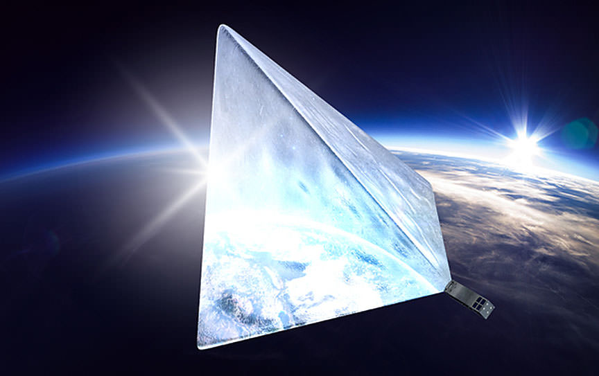
We may soon look up and see a satellite brighter than the space station and even Venus gliding across the night sky if a Russian crowdfunding effort succeeds. An enthusiastic team of students from Moscow University of Mechanical Engineering are using Boomstarter, the Russian equivalent of Kickstarter, to raise the money needed to build and launch a pyramid-shaped satellite made of highly reflective material they’re calling Mayak, Russian for “Beacon”.


Young engineers at Moscow University explain the Mayak Project

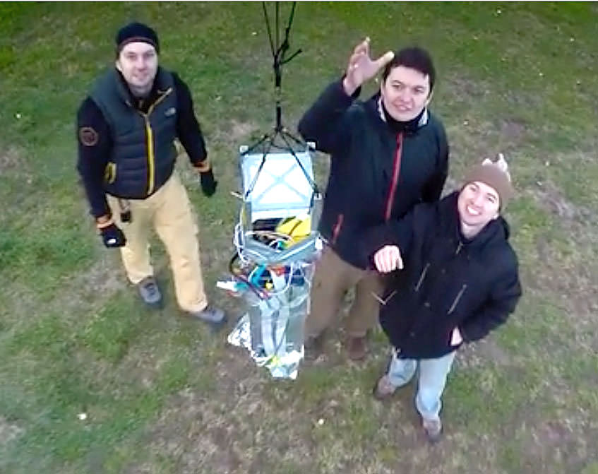
To date they’ve collected more than $23,000 or 1.7 million rubles. Judging from the video, the team has built the canister that would hold the satellite (folded up inside) and performed a high-altitude test using a balloon. If funding is secured, Beacon is scheduled to launch on a Soyuz-2 rocket from the Baikonur Cosmodrome in the second quarter of this year.

Illustration of the “Beacon” unfurling from its canister when it reaches orbit. The Mayak Project used the Russian version of Kickstarter called Boomstarter to fund the project. Credit: cosmomayak.ru / Mayak Project
Illustration of the “Beacon” inflating from its canister after reaching orbit. The Mayak Project used the Russian version of Kickstarter called Boomstarter to fund the project. Credit: cosmomayak.ru / Mayak Project

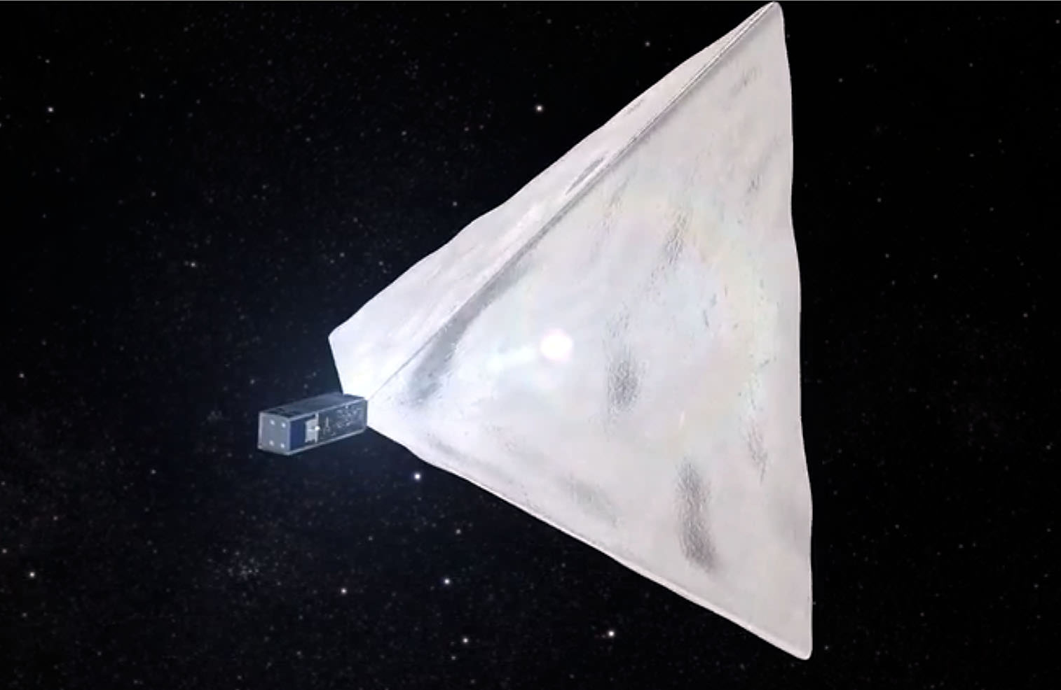
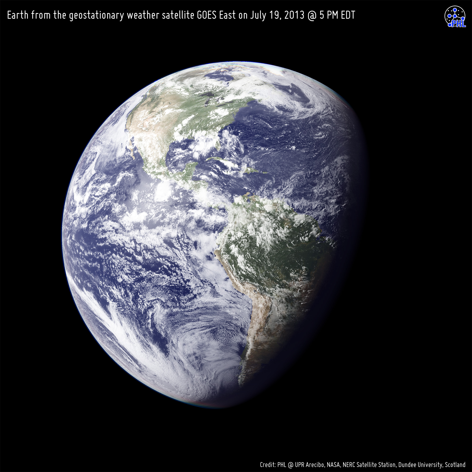
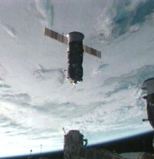
Once in orbit, Beacon will inflate into a pyramid with a surface area of 172 square feet (16 square meters). Made of reflective metallized film 20 times thinner than a human hair, the satellite is expected to become the brightest man-made object in orbit ever. That title is currently held by the International Space Station which can shine as brightly as magnitude -3 or about three times fainter than Venus. The brightest satellites, the Iridiums, can flare to magnitude -8 (as bright as the crescent moon) but only for a few seconds before fading back to invisibility. They form a “constellation” of  some 66 satellites that provide data and voice communications.

A student at the Mayak Lab in Moscow describes the container used to hold the reflective "Beacon" satellite. Credit:
A student at the Mayak Lab in Moscow describes the container used to hold the reflective “Beacon” satellite. Credit: cosmomayak.ru / Mayak Project

A concurrently-developed mobile app would allow users to know when Beacon would pass over a particular location. The students hope to achieve more than just track a bright, moving light across the sky. According to their website, the goal of the project is the “popularization of astronautics and space research in Russia, as well as improving the attractiveness of science and technology education among young people.” They want to show that almost anyone can build and send a spacecraft into orbit, not just corporations and governments.

Further, the students hope to test aerodynamic braking in the atmosphere and find out more about the density of air at orbital altitudes. Interested donors can give anywhere from 300 rubles (about $5) up 300,000 ($4,000). The more money, the more access you’ll have to the group and news of the satellite’s progress; the top donor will get invited to watch the launch on-site.

Moscow University students release the satellite on a test run. Credit: cosmomayak.ru / Mayak Project
Liftoff! Moscow University students release the satellite on a test run. Credit: cosmomayak.ru / Mayak Project

Once finished with the Mayak Project, the team wants to built another version that uses that atmosphere for braking its speed and returning it — and future satellites — safely back to Earth without the need for retro-rockets.

I think all these goals are worthy, and I admire the students’ enthusiasm. I only hope that satellite launching doesn’t become so cheap and popular that we end up lighting up the night sky even further. What do you think?

This is Our Planet From a Million Miles Away

Earth imaged on July 6, 2015 by NOAA's DSCOVR satellite from L1. Credit: NOAA/NASA/GSFC

This picture of our home planet truly is EPIC – literally! The full-globe image was acquired with NASA’s Earth Polychromatic Imaging Camera (aka EPIC; see what they did there) on board NOAA’s DSCOVR spacecraft, positioned nearly a million miles (1.5 million km) away at L1.

L1 is one of five Lagrange points that exist in space where the gravitational pull between Earth and the Sun are sort of canceled out, allowing spacecraft to be “parked” there. (Learn more about Lagrange points here.) Launched aboard a SpaceX Falcon 9 on Feb. 11, 2015, the Deep Space Climate Observatory (DSCOVR) arrived at L1 on June 8 and, after a series of instrument checks, captured the image of Earth’s western hemisphere above on July 6.

The EPIC instrument has the capability to capture images in ten narrowband channels from infrared to ultraviolet; the true-color picture above was made from images acquired in red, green, and blue visible-light wavelengths.

More than just a pretty picture of our blue marble, this image will be used by the EPIC team to help calibrate the instrument to remove some of the blue atmospheric haze from subsequent images. Once the camera is fully set to begin operations daily images of our planet will be made available on a dedicated web site starting in September.

DSCOVR's location at L1 (NOAA/NASA)
DSCOVR’s location at L1 (NOAA/NASA)

Designed to provide early warnings of potentially-disruptive geomagnetic storms resulting from solar outbursts, DSCOVR also carries Earth-observing instruments that will monitor ozone and aerosols in the atmosphere and measure the amount of energy received, reflected, and emitted by Earth – the planet’s “energy budget.

But also, from its permanent location a million miles away, DSCOVR will be able to get some truly beautiful – er, EPIC – images of our world.

DSCOVR is a joint mission between NOAA, NASA, and the U.S. Air Force. Learn more about DSCOVR here.

Source: NASA

UPDATE: President Obama liked this image so much, he decided to Tweet about it with a message of planetary conservation!

The POTUS' Tweet about the DSCOVR image on July 20, 2015.
The POTUS’ Tweet about the DSCOVR image on July 20, 2015.

UPDATE 7/29/15: Here’s another view from DSCOVR on July 6, showing Europe, Africa, and the Middle East:

DSCOVR image of Earth from July 6, 2015. (NASA/NOAA)

What is the Moon’s Real Name?

What is the Moon’s Real Name?

We call it the Moon, but… what’s its real name? You know, the name that scientists call the Moon.

As of 2015, there are 146 official moons in the Solar System, and then another 27 provisional moons, who are still waiting on the status of their application. All official moons have names after gods or Shakespeare characters. Names like Callisto, Titan, or Prometheus. But there’s one moon in the Solar System with a super boring name… the one you’re most familiar with: Moon.

But come on, that’s such a boring name. Clearly that’s just its common name. So what’s the Moon’s real name? Its scientific name. The neato cool name. Like Krelon, Krona, Avron or Mua’Dib.

Are you ready for this? The answer is: The Moon. Here’s some hand-waving and excuse making. Really, this is our own damn fault. Until Galileo first turned his telescope to the skies in 1610, and realized that Jupiter had tiny spots of light orbiting around it, astronomers had no idea other planets had moons.

Humans have been around for a few hundred thousand years, and the Moon was a familiar object in the sky. We’ve only had evidence of other moons for a little over 400 years. We didn’t collectively understand the Earth was a planet until Copernicus developed the heliocentric model of the Solar System.

We still have a little trouble with that, even though we’re firing a probe directly at the Sun. We didn’t give into the idea that the Sun was a star until recently. Giordano Bruno proposed the idea in 1590 and we burned him at the stake for suggesting it. Seriously, I can’t stare at this any longer. Yes, we’re awful. I’m going to talk about “the Moon” again.

Scientists classify the Moon as a natural satellite. Somehow this helps distinguish it from the artificial satellites we’ve been launching for the last 60 years.

High resolution photo map of the moon's far side imaged by NASA's Lunar Reconnaissance Orbiter. Mare Moscoviense lies at upper left and Tsiolkovsky at lower left. Click for a hi res image. Credit: NASA
High resolution photo map of the moon’s far side imaged by NASA’s Lunar Reconnaissance Orbiter. Credit: NASA

What about terms like “Luna”? That’s Latin for Moon. It’s not an official title or scientific term, but ooh, fancy. Latin.

If you want to make sure people know you’re talking about “The Moon” and not “a moon”, it’s all about capitalization. Put a capital “M” in front of “oon” and you’re good to go.

The name of our solar system? It’s the Solar System (again, capitalized). Our galaxy? The Galaxy with a capital G. The universe? Capital U Universe.

What about the Sun? Isn’t it “sol”? That’s just the Latin word for “sun”. Helios? Greek God version of the Sun.

If we ever discover that we’re really living in a multiverse, we’ll need to give those other universes names. And people will wonder what the actual official title is for the Universe. I’ll make another video when that happens, I promise.

The official advice from the International Astronomical Union, who are the people you’re still mad at about Pluto, is that the capitalization is what makes the definition.

Supermoon through the clouds on September 9, 2014. Credit and copyright: scul-001 on Flickr.

Not everyone in the world adheres to the capitalization so carefully, which can tend to some confusion. Are we talking about the sun or the Sun? As someone who writes space articles, let me assure you, messing this up will light up the comments section with “Which is better Deep Space 9 vs. Voyager” level of shrill all caps screaming.

Calling it “the Moon” is kind of boring, but that’s only because scientific discovery has pushed our understanding of the Universe so far out. It’s amazing to think that we’ve discovered so many other moons in the Solar System, and soon, we’ll find them around other stars.

So, for now it’s The Universe. When we find others, this one will still be THE Capital-U Universe and the new ones will be Nimoy and Sagan and Clarke.

Why don’t we give the Moon a new name. Something with a little more razzle-dazzle. Make your suggestions in the comments below. Alternately, suggest a fancy Latin name of “Guide to Space”, I’ve got dibs on “Aether Libris”.

Thanks for watching! Never miss an episode by clicking subscribe.

No, This Is Not a Photo of India on Diwali

Yes, it's India, but it's not a photo captured from space during Diwali night. (Credit: NASA)

Diwali, the Indian festival of lights, falls on Thursday, Oct. 23 this year and with it come celebrations, gift-giving, and brilliant lighting and firework displays all across the subcontinent of India… but this isn’t a picture of that. What is it exactly? Find out below…

Over the past several years this image has repeatedly resurfaced online, especially around the time of Diwali. And understandably so: it’s a beautiful view of India seemingly decorated for the festival… one can easily imagine the entire country awash in colorful lights from shore to shore.

But it’s not a photo at all, or even a singular image. Rather it’s a composite of many images acquired from a USAF Defense Meteorological Satellite Program (DMSP) satellite over the course of several years, and assembled by NOAA scientist Chris Elvidge to show the country’s growing population and urban areas.

In a 2012 article by Robert Johnson on Business Insider a NASA spokesperson described the colors in the image: “The white lights were the only illumination visible before 1992. The blue lights appeared in 1992. The green lights in 1998. And the red lights appeared in 2003.”

So what does India look like at night during the five-day-long Diwali festival? Click here and see.

While city lighting in India is definitely visible from space, it’s not the rainbow explosion of neon colors that Internet hoaxers and uninformed online enthusiasts would eagerly have you believe. According to Adam Voiland on the NASA Earth Observatory site, “in reality, any extra light produced during Diwali is so subtle that it is likely imperceptible when observed from space.”

So this year, don’t fall for any false descriptions of this picture… and, Happy Diwali!

Sources: Business Insider, Mashable, NASA Earth Observatory, EarthSky. Read more about the 2014 celebration of Diwali here.

HT to Peter Caltner on Twitter for re-alerting me of this.

How Many Satellites are in Space?

How Many Satellites are in Space?

The space age began on October 4, 1957 with the launch of the first artificial satellite, Sputnik 1. This tiny spacecraft lasted only three months in orbit, finally burning up in the Earth’s atmosphere.

Following in these historic footsteps, many more spacecraft have been sent into Earth’s orbit, around the Moon, the Sun, the other planets, and even out of the Solar System itself. At the time that I’m recording this video, there are 1071 operational satellites in orbit around the Earth. 50 percent of which were launched by the United States.

Half of that 1071 are in Low-Earth Orbit, just a few hundred kilometers above the surface. Some of the most notable of these include the International Space Station, the Hubble Space Telescope, and many Earth observation satellites.

About a twentieth are in Medium-Earth Orbit, around 20,000 kilometers up, which are generally global positioning satellites used for navigation. A small handful are in elliptical orbits, where their orbit brings them closer and further to the Earth.
The rest are in geostationary orbit, at an altitude of almost 36,000 kilometers.

If we could see these satellites from Earth’s surface, they would appear to hang motionless in the sky. The fact that they remain over the geographic same area means they provide the perfect platform for telecommunications, broadcast or weather observations.

But there are many, many more artificial objects orbiting the Earth. In this collection of space debris we’re talking spent boosters, dead satellites, and even misplaced gloves. According to the United States Space Surveillance Network, there are more than 21,000 objects larger than 10 cm orbiting the Earth. Just a small fraction of these are operational satellites. It’s estimated there are a further 500,000 bits and pieces between 1 and 10 cm in size.

Near Earth orbit is so polluted with junk that the International Space Station is often moved to avoid impact with dangerous chunks of space debris. Many of these objects are created through collisions, and some scientists are worried that future space travel might be too risky if we get too much junk orbiting the planet. We might seal ourselves inside a shield of shrieking metal moving at 29,000 km/hour.

Looking outwards from our own orbit, at any time there are a handful of satellites orbiting the Moon. Right now, NASA’s Lunar Reconnaissance Orbiter and Lunar Atmosphere and Dust Environment Explorer are in lunar orbit. Further still, there’s 1 spacecraft around Mercury, 1 at Venus, 3 visiting Mars and 1 orbiting Saturn. There’s a handful of spacecraft orbiting the Sun, although they’re leading or trailing the Earth in its orbit. And a few spacecraft are on trajectories to take them out of the Solar System entirely. NASA’s Voyager spacecraft, exited the Sun’s heliosphere in 2013, and entered the interstellar medium.

Starting with Sputnik’s lonely journey over 50 years ago, It’s amazing to consider just how many satellites we’ve already launched into space in just a few decades. With more launches all the time, space is becoming a busy place, with so many exciting missions to look forward to.

We have written many articles about satellites for Universe Today. Here’s an article about two satellites that collided in Earth orbit, and here are some pictures of satellites.

You can learn more about the US Space Surveillance Network from the United States Strategic Command website.

We have also recorded a whole episode of Astronomy Cast about space junk. Listen here, Episode 82: Space Junk.

30 Years of City Growth Seen From Space

China's now-industrialized Pearl River Delta, seen in October 1973 (top) and January 2003 (bottom)

Since the launch of its first satellite in 1972, the eight NASA/USGS Landsat satellites have made the longest continuous observations of Earth’s surface, providing invaluable data for research in agriculture, geology, forestry, regional planning, education, mapping, global change research, as well as important emergency response and disaster relief information. In addition, having such a long span of data allows us to easily see the expansion of human development in many areas — unprecedented before-and-after views of city growth seen from space.

These images, taken over the course of the Landsat program, illustrate the visible impact of over three decades of human development:

Chandler, Arizona imaged in 1985 (top) and 2011 (bottom.)  As its economy shifted from agriculture to manufacturing and electronics, Chandler's population multiplied 8 times to over 236,000.
Chandler, Arizona imaged in 1985 (top) and 2011 (bottom.) As its economy shifted from agriculture to manufacturing and electronics, Chandler’s population multiplied 8 times to over 236,000.
The explosion of Istanbul's population from 2 to 3 million people is evident in these Landsat images, comparing 1975 to 2011. Vegetation appears red in the imaging wavelengths used here.
The explosion of Istanbul’s population from 2 to 13 million people is evident in these Landsat images, comparing 1975 to 2011. Vegetation appears red in the imaging wavelengths used here.
A few years ago one of the fastest-growing cities in the US, Las Vegas is seen here in images taken in 1984 (top) and 2011 (bottom.) The sprawling development -- as well as the decrease in water level of Lake Mead -- is evident.
A few years ago one of the fastest-growing cities in the US, Las Vegas is seen here in images taken in 1984 (top) and 2011 (bottom.) The sprawling development — as well as the decrease in water level of Lake Mead — is evident.
Some of the most dramatic -- and rapid --  changes have occurred in Dubai, whose artificial offshore islands suddenly appear between images taken in 2000 (top) and 2010 (bottom.) Once barely visible against the desert landscape, Dubai is now an international center of business, tourism, and oil production.
Some of the most dramatic — and rapid — changes have occurred in Dubai, whose palm- and continent-shaped artificial islands suddenly appear between images taken in 2000 (top) and 2010 (bottom.) Once barely visible against the desert landscape, Dubai is now an international center of business, tourism, and oil production.

See more of these images on NASA Goddard Space Flight Center’s Flickr album here.

The Landsat Program is a series of Earth-observing satellite missions jointly managed by NASA and the U.S. Geological Survey. In 1972, the launch of ERTS-1 (Earth Resources Technology Satellite, later renamed Landsat 1) started the era of a series of satellites that have since continuously acquired space-based land remote sensing data.

The latest satellite in the Landsat series, the Landsat Data Continuity Mission (LDCM) — now named Landsat 8 — was launched on February 11, 2013. Landsat 8 data is now available free to the public online here.

Read more on the USGS Landsat mission page here.

Image credits: USGS/NASA

Could Cassini See You On “The Day The Earth Smiled?”

The face of Earth aimed toward Cassini during imaging on July 19, 2013

So along with the rest of the world, you smiled. You waved. You went outside on July 19, wherever you were, and looked upwards and out into the solar system knowing that our robotic representative Cassini would be capturing a few pixels’ worth of photons bouncing off our planet when they eventually reached Saturn, 900 million miles away. But did Cassini actually capture any photons coming from where you were? The image above will tell you.

Assembled by the Planetary Habitability Laboratory at the University of Puerto Rico at Arecibo (where the enormous 305-meter radio telescope is located) this image shows what side of Earth was facing Cassini when its “pale blue dot” images were obtained, at approximately 22:47 UTC (Cassini time.)

Didn’t make it into Cassini’s photo? That’s ok… maybe MESSENGER had already caught you earlier that very same day:

The view of Earth seen by MESSENGER from Mercury on July 19, 2013

Before Cassini took its images — several hours before, in fact — the MESSENGER spacecraft was holding some photo shoots of its own from 61 million miles in the other direction!

The image above shows the side of Earth that was facing Mercury on the morning of July 19, 2013, when MESSENGER was acquiring images in our direction during a hunt for any possible satellites of the innermost planet.

Earth was as bright (-4.8 magnitude) as the maximum brightness of Venus at the moment the image was taken from Mercury.

Of course, in both series of images specific details of our planet can’t be made out — Earth was barely more than a pixel in size (regardless of any bloom caused by apparent brightness.) Clouds, countries, continents, oceans… the entire population of our world, reduced to a single point of light — a “mote of dust suspended in a sunbeam.”

For both portrayals, high-resolution black and white images from the GOES East and Meteosat meteorological satellites were combined with color information from NASA Visible Earth to generate true-color images of our planet as it would have looked to each respective imaging spacecraft… if they had the impossibly-precise optics to resolve Earth from such distances, of course.

But it’s ok that they don’t… we can still use our imaginations.

Read more here on the PHL’s news release.

Earth from the geostationary weather satellite GOES East on July 19, 2013 at 5 PM EST. This is approximately the view that Cassini would have had of Earth during imaging.

Image credits: PHL @ UPR Arecibo, NASA/Johns Hopkins University Applied Physics Laboratory/Carnegie Institution of Washington, NERC Satellite Station, Dundee University, Scotland. Thanks to Prof. Abel Méndez (PHL/UCR) for the heads-up on these.

A Heat Wave So Big You Can See It From Space

Image taken by NOAA's GOES East satellite at 12:45 p.m. EDT on July 15, 2013. (NOAA/NASA GOES Project)

Hot enough for ya? If you live anywhere on the eastern half of the United States (like me) you’ve probably been sweating it out over the past several days in what certainly feels like the warmest week yet for the season. The cause of the oppressive weather? A large mid-level ridge centered over the Ohio Valley — large enough to be easily visible from space.

The image above was taken by the GOES East satellite at 12:45 p.m. EDT on July 15. The clear area over Ohio shows the center of the system, which has been driving temperatures up into the 90s for much of the eastern U.S. and is expected to expand into the plains by mid-week. Along with increased humidity, heat index values will exceed 100 ºF and even approach 110 ºF on Friday.

From the NASA Image of the Day page:

A very anomalous weather pattern is in place over the U.S. for mid-July. Trapped between an upper level ridge centered over the Ohio Valley and the closed upper level low over the Texas/Oklahoma border, atypical hot, muggy air is stifling a broad swath of the eastern U.S. The closed low is expected to drift west toward New Mexico bringing heavy, localized rain to some areas and temperatures running 10-20 degrees below mid-July averages. Across the east, temperatures will warm well into the 90s and stay there through the week. (NOAA)

Rendering of a GOES satellite (NOAA)

As of the time of this writing heat advisories are in place in many parts of Michigan, southern Minnesota, and southern New England, and excessive heat warnings are active in eastern Pennsylvania and west central New Jersey. (Source)

Click here for summer heat safety tips.

Meanwhile, a closed low — seen above as a large, moisture-laden spiraling cloud system — is moving west across Texas and New Mexico, and is expected to bring lower-than-average temperatures along with heavy rains and flash flooding.

Keep up to date with weather alerts for your area at the NOAA’s National Weather Service site here, and see the latest GOES satellite images here.

Image Credit: NOAA/NASA GOES Project

At an altitude of 22,336 miles, the geosynchronous GOES satellites continuously provide observations of 60 percent of the Earth including the continental United States, providing weather monitoring and forecast operations as well as a continuous and reliable stream of environmental information and severe weather warnings.

Did a Piece of Mir Really Land in Massachusetts?

Screenshot closeup of the Amesbury Mass. find.

We love a good space debris mystery. Hey, who doesn’t, right?  Regular readers of Universe Today know that it’s a shooting gallery out there, from meteor fireballs caught on dashboard cams to rogue space junk reentries lighting up our skies. 

But an unusual story that made its rounds across the internet this past weekend caught our attention. What at first glance was a simple “Man finds space rock” story morphed into an extraordinary claim, which, in the words of the late great Carl Sagan, “demand extraordinary evidence.”

The find was made by Phil Green of Amesbury, Massachusetts. Mr. Green was searching the local riverbed for arrowheads when he came across the unusual find. The black pitted rock immediately struck him as something bizarre.  It didn’t register as metallic to his metal detector, but Mr. Green kept it in his backyard for about five years until it was noticed by a friend.

“I didn’t really think much of it, and then a fellow came over, saw it and said that’s a meteor,” Green told local reporters.

From here, the story takes a strange turn. Green told local reporters that the rock was sent off for analysis, only to be returned to him just a few weeks ago. The analysis confirmed that the rock was indeed from space… sort of. It also stated that the vitreous material “shows a composition similar to that used in ballast by the Soviet space program starting in the mid-1980s.”

And the word was out. The media quickly ran with the “Man finds a piece of Mir” story.

There are just a few problems with the tale. Mir reentered in 2001, six years before the 2007. A few articles do bother to note this, mentioning that Mir ended its career in the “so-called spacecraft cemetery of the southern Pacific Ocean,” about as far away from Massachusetts as you can get.

A few articles do also mention the possibility of a reentry of a Progress resupply vehicle being a potential source, or perhaps an unrelated Russian space vehicle.

But there seems to be a potential problem of the certification. Several articles state that the piece of debris coming from Mir was “confirmed by NASA.” However, Universe Today contacted NASA Chief Scientist for Orbital Debris Nicholas L. Johnson and NASA Headquarters official Joshua Buck, who both told us that no such NASA validation exists. Mr. Johnson went on to tell Universe Today that, “The NASA Orbital Debris Program Office has not been presented with any claim regarding debris from the Mir space station,” adding “I can tell you that it is not possible for debris from the Mir reentry to have landed in the U.S.”

A name that occasionally turns up in reports online as validating the find (withheld by request) also tells Universe Today that they had nothing to do with the discovery. Mr. Green or the original validation source  have thus far been unavailable for comment.

We did uncover two documented reentries that occurred over the general region over the last few decades. One is the reentry of Mir-R 1986-017B (The rocket booster that launched the core module of Mir) seen from a trans-Atlantic airliner on February 24th 1986 about 500 kilometres off of the east coast of Newfoundland. Another possible suspect is the June 26/27th 2004 reentry of a SL-12 auxiliary rocket motor with the NORAD ID 1992-088E, seen to the west from New Jersey to Ontario.

Like the International Space Station, Mir was placed in a 51.6° inclined orbit. This made it accessible from the Baikonur Cosmodrome as well as visits from the U.S. Space Shuttle. Payloads going to and from the station would cover an identical ground track ranging from 51.6° north to south latitude.

The story is also reminiscent of the reentry of debris from Sputnik 4, which struck a small town in Wisconsin in 1962. This was analyzed by mineralogist Ursula Marvin and confirmed to be of Russian origin.

A Progress spacecraft inbound for docking with the International Space Station. (Credit: NASA).

Probably the biggest question in our minds is: what links the object back to an errant Russian spacecraft? What do they use for ballast, anyhow? How did they arrive at the often quoted “85% certainty?” of the object’s origin?

Still, the find does look like something interesting. The pitting and the melted fusion crust are all reminiscent of reentry. We’ll keep researching this story, and for the time being we’ll leave it up to you, the diligent and insightful readers of Universe Today, to make up your own minds on this strange and interesting tale.

Weird Gravity Waves Pulse From a Tropical Cyclone

Nighttime image of southern India and Tropical Cyclone Mahasen (NASA/NOAA)

Last Monday, May 13, the Suomi NPP satellite captured a fascinating image of Tropical Cyclone Mahasen as it moved northeast over the Bay of Bengal. The clouds of the storm itself weren’t optically visible in the darkness of a nearly new Moon, but lightning flashes within it were… as well as the eerie ripples of atmospheric gravity waves spreading outwards from its center.

According to the Space Physics Research Group at the University of California, Berkeley:

Gravity waves are the oscillations of air parcels by the lifting force of bouyancy and the restoring force of gravity. These waves propagate vertically as well as horizontally, and actively transport energy and momentum from the troposphere to the middle and upper atmosphere. Gravity waves are caused by a variety of sources, including the passage of wind across terrestrial landforms, interaction at the velocity shear of the polar jet stream and radiation incident from space. They are found to affect atmospheric tides in the middle atmosphere and terrestrial weather in the lower atmosphere. (Source)

Atmospheric gravity waves aren’t to be confused with gravitational waves in space, which are created by very dense, massive objects (like white dwarf stars or black holes) orbiting each other closely.

When the image was captured, Tropical Cyclone Mahasen was moving north through the Indian Ocean along a track that placed landfall along the Bangladesh coast. As it moved off the coast of India Suomi’s VIIRS Day-Night Band was able to resolve lightning flashes towards the center of the storm, along with mesopheric gravity waves emanating outwards like ripples in a pond.

Such gravity waves are of particular interest to air traffic controllers so assist in identifying areas of turbulence.

Since the moon was in a new phase, the lights and other surface features of India and Sri Lanka are clearly visible although the clouds of Mahasen are not — a tradeoff that occurs as the amount of moonlight cycles throughout the month.

TS Mahasen on May 17, 2013 (Chelys/EOSnap)

Over the course of the next few days Mahasen weakened into a deep depression, making landfall as a tropical storm on Bangladesh on May 16. In preparation for the storm large-scale evacuations were recommended for parts of Myanmar; however, this resulted in the overcrowding of boats and several vessels capsized. (Source: eosnap.com)

NASA launched the National Polar-orbiting Operational Environmental Satellite System Preparatory Project (or NPP) on October 28, 2011 from Vandenberg Air Force Base. On Jan. 24, NPP was renamed Suomi National Polar-orbiting Partnership, or Suomi NPP, in honor of the late Verner E. Suomi. It’s the first satellite specifically designed to collect data to improve short-term weather forecasts and increase understanding of long-term climate change.

Suomi NPP orbits Earth about 14 times a day, observing nearly the entire surface of the planet.

Main image source: NASA Goddard Space Flight Center