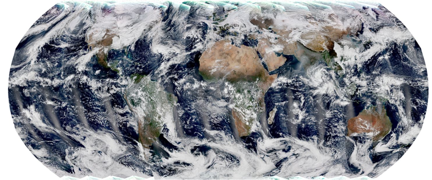
Polar-orbiting satellites capture swaths of data throughout the globe, and observe the entire planet twice each day. The global mosaic, captured by the VIIRS instrument on the recently launched NOAA-21 satellite, is a composite image created from these swaths. Image Credit: NOAA STAR VIIRS Imagery Team.
You’d have to be in some kind of sense-of-wonder-repressed coma not to appreciate satellite images of Earth. If you are, then images from the NOAA’s newest satellite might pull you out of it.
And they’re only a taste of the fascinating images that it will provide.
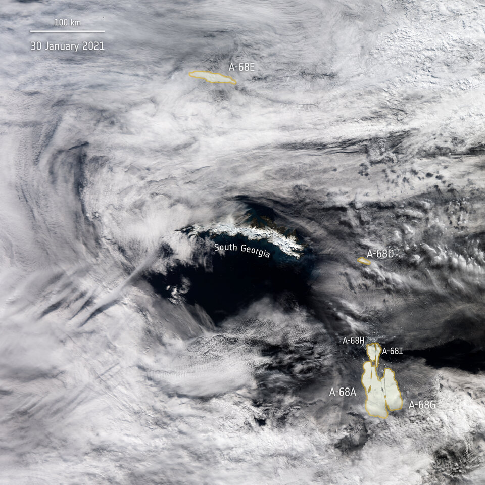
A-68 iceberg positions as seen by Copernicus Sentinel-3 mission on January 30 2021. Image Credit: ESA
Iceberg A-68A, the massive frigid behemoth posing a threat to South Georgia Island, might be breaking into pieces. Satellite images from the European Space Agency showed large cracks forming in the iceberg.
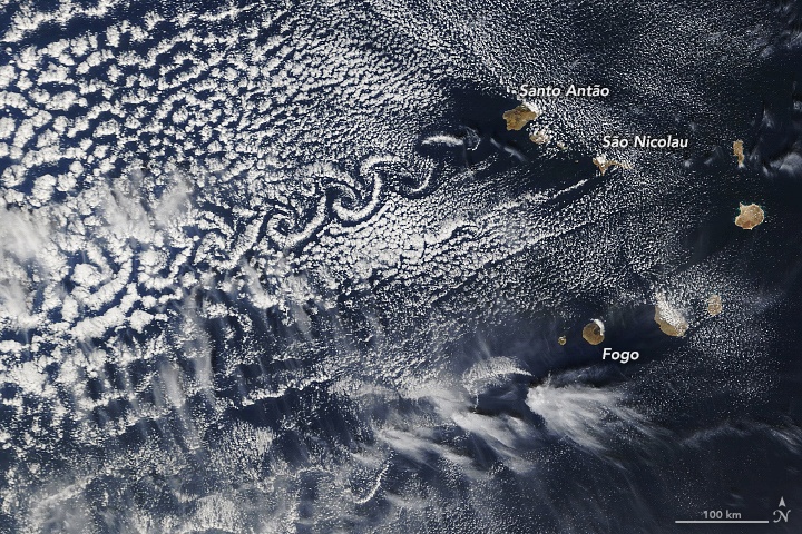
Three peaks in Cape Verde form von Kármán vortex streets when wind conditions are right. Image Credit: Lauren Dauphin, using MODIS data from NASA EOSDIS/LANCE and GIBS/Worldview.
This is an image of some of the islands that make up the nation of Cape Verde. While most in that group of ten islands are flat, some are very tall: Fogo, Santa Antão, and São Nicolau. Those three stand well above their compatriots, with Fogo reaching an altitude of 2,829 metres (9,281 feet).
The three tall volcanic islands sometimes interact with the wind to create von Kármán vortices, also called von Kármán vortex streets.
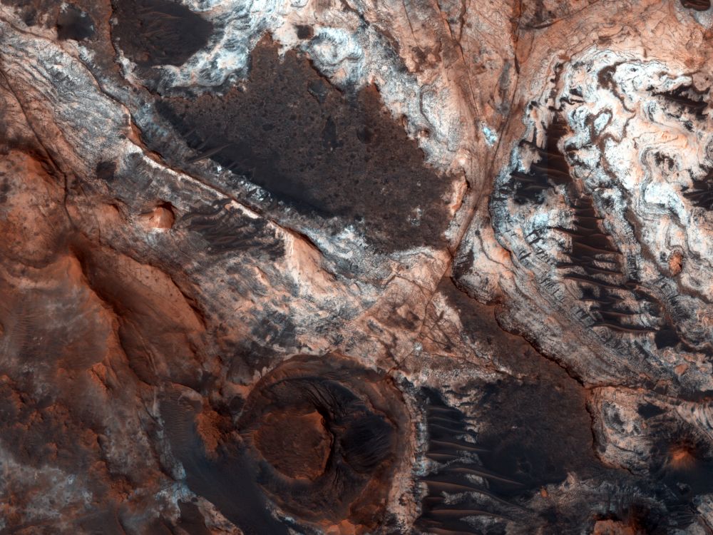
This image shows a small portion of Mawrth Vallis, one of the many outflow channels feeding north into the Chryse Basin. This ancient valley once hosted flowing water. The erosive power of the flowing water rapidly cut down into the underlying layers of rock to expose a host of diverse geologic landforms visible today. Image Credit: NASA/JPL/UArizona
Here on Earth, geologists seek out deep channels into Earth’s rock, carved over the ages by flowing water. The exposed rock walls are like a visual timeline of a region’s geological history. On Mars, the surface water is long gone. But it flowed long enough to expose layers of rock just like here on Earth.
One of those water-exposed areas on Mars is Mawrth Vallis, an outflow channel that feeds into the Chryse Basin.
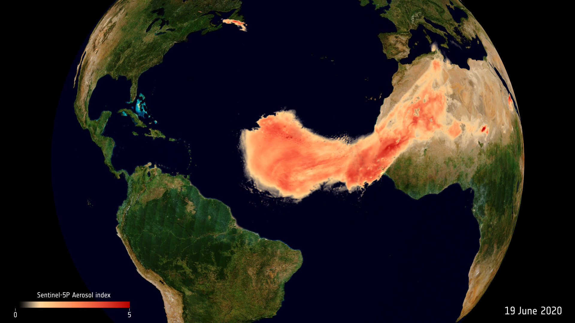
The Saharan dust plume over the Atlantic Ocean. Image Credit: contains modified Copernicus Sentinel data (2020), processed by ESA, CC BY-SA 3.0 IGO
Dust plumes are a natural phenomena, part of Earth’s nutrient cycle. They occur when high-velocity winds pick up tiny dry particles from the Earth’s surface and carry them long distances. Every summer, dust plumes from Africa’s Sahara desert travel across the Atlantic Ocean.
They’re usually not this big, and they often sink into the ocean. But this one’s coming right to America.
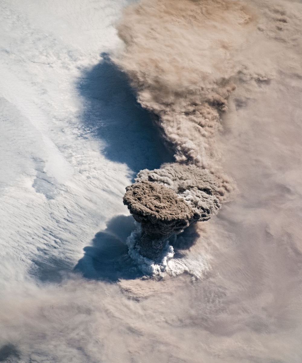
The Raikoke Volcano erupting on June 22nd, as imaged by NASA astronauts on the ISS. Image Credit: NASA
The Raikoke Volcano, dormant for a very long time, has awoken from its slumber. The volcanic island is in the Kuril Island chain, near the Kamchatka Peninsula in Russia. Unlike its more volcanically active neighbours, Raikoke has been dormant since 1924.
Thanks to astronauts on the International Space Station, we have gorgeous photos of the eruption.
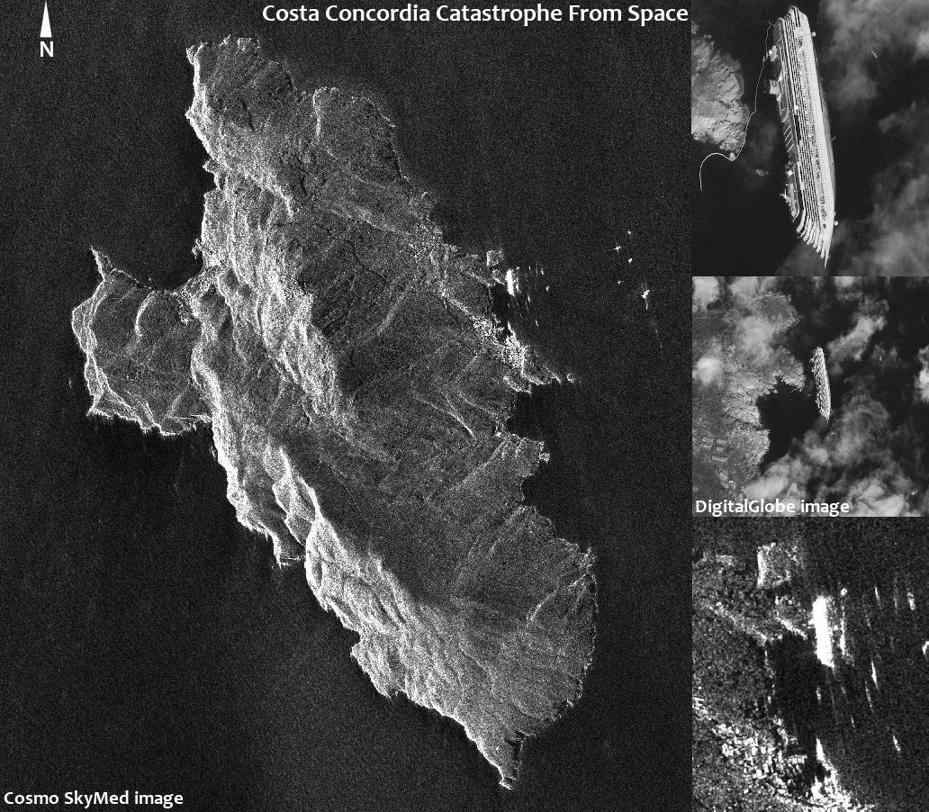
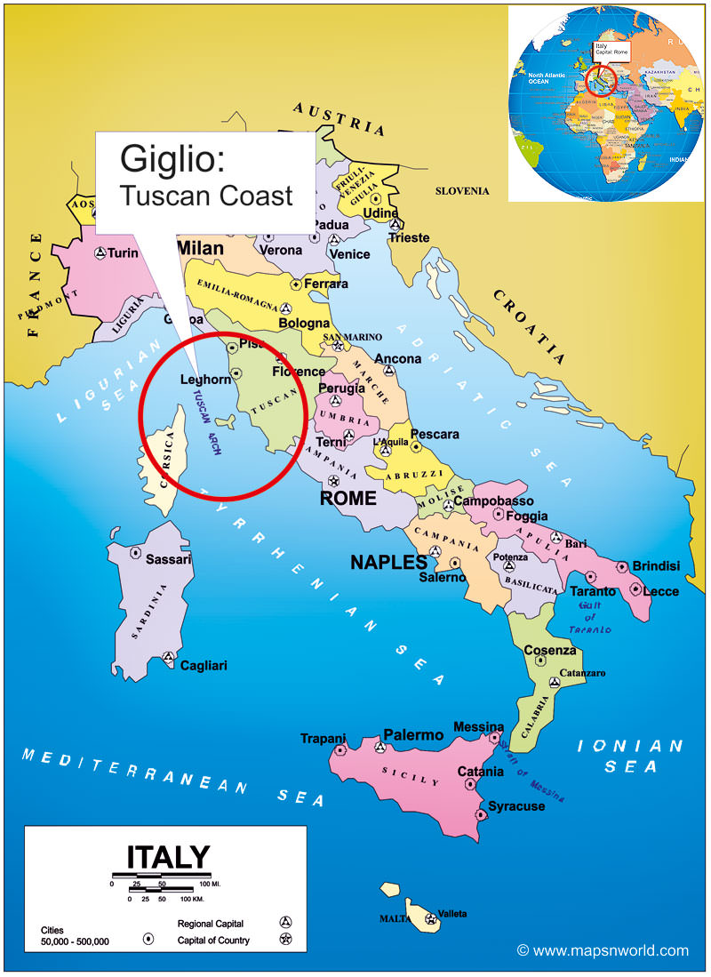
Space Radar Image of Costa Concordia Cruise Ship Catastrophe, Giglio, Italy- January 17, 2012. Image mosaic shows side-by-side comparison of radar and photo imagery from space satellites showing the deadly wreckage of the Costa Concordia luxury cruise ship which ran aground off the shoreline of Giglio,Italy on Friday, January 13, 2012. Image Credit: COSMO-SkyMed (left, bottom right) & DIGITALGLOBE (top, middle right). Mosaic: Marco di Lorenzo/Ken Kremer More Images and Passenger Video below
[/caption]
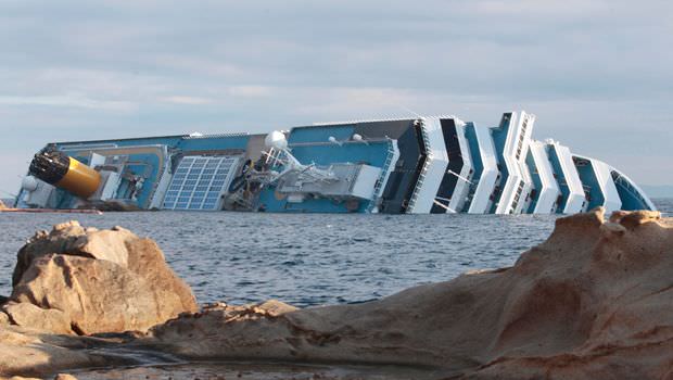
An amazing new radar image from space (above and below) shows the wreckage of the deadly Costa Concordia catastrophe just hours after the luxury cruise liner struck gigantic rocks jutting up from the shoreline of the Island of Giglio [Isola del Giglio] off the coast of Tuscany, Italy on Friday the 13th of January 2012, sending thousands of terrified tourists screaming for their very lives.
The radar image was snapped by chance during a routine reconnaissance survey by an Italian COSMO-SkyMed satellite orbiting above the Earth, according to the Italian Space Agency (ASI) and clearly shows the Costa Concordia wreckage and entire island of Giglio.
Our composite mosaic above combines the COSMO-SkyMed space radar image with the DigitalGlobe WorldView satellite photo, to provide a side-by-side comparison of the wreckage from the two different satellite systems which have different resolutions. Read my prior story with the stunning DigitalGlobe image – here at Universe Today.
At least 11 people were killed in the still unfolding tragedy and another two dozen people are still missing today, January 19.
Look at this dramatic new YouTube video of passengers scrambling to stay alive
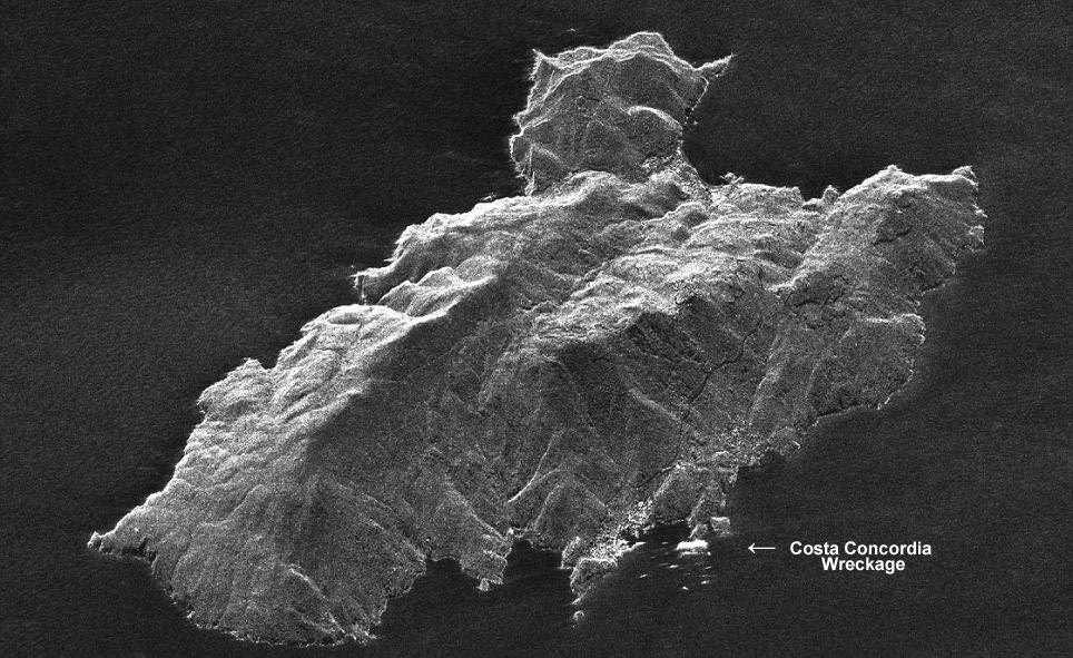
The COSMO-SkyMed satellite normally takes repeat radar images every 16 days. In the case of an oil spill, the satellite would enter automatically an “emergency mode” and start taking very-high resolution images of the affected region, according to ASI.
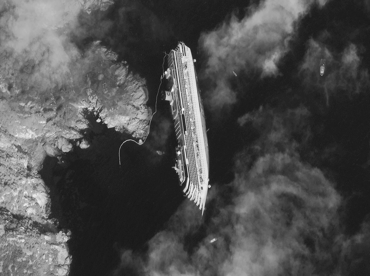
Severe weather is approaching and could break the ship apart according to news reports. Space Radar Image of Costa Concordia Cruise Ship Wreckage, Giglio, Italy- January 13, 2012
COSMO-SkyMed space radar image taken just hours after Costa Concordia luxury cruise ship ran aground off the shoreline of Giglio, Italy on 13 Jan. 2012. Credit: COSMO-SkyMed
The Costa Concordia is loaded with several thousand gallons of diesel fuel oil and officials are concerned about the very real potential for a leak which could contaminate the beautiful surroundings and harm the local environment
Location Map of Costa Concordia Shipwreck
off the Tuscan coastline of Giglio, Italy
The deadly Jan. 13 collision tore a 70 meter long gash in the ship’s hull, causing the Costa Concordia cruise liner to begin listing. Ultimately the ship fell on its side as it was steered into shallow waters.
Rescue operations resumed today although the ship is still shifting and hazardous to the brave rescue teams.
Helicopters lowered emergency workers onto the top of the wreckage. Divers working below used explosives to blast open new holes in the hull to get to any survivors.
And still more Italian emergency personnel could be seen scaling up the sides – all in a desperate attempt to reach survivors from every possible angle.
But sadly, hopes are fading. A 5 year old Italian girl and her father are among the missing.
Costa Concordia Shipwreck occurred on January 13, 2012
COSMO-SkyMed is a constellation of four Italian satellites that are equipped with Synthetic Aperture Radar (SAR) sensors that provide global coverage of the planet that serves both military and civilian uses such as seismic hazard analysis, environmental disaster monitoring, and agricultural mapping.
The COSMO-SkyMed space radar system provides all weather imagery and is funded by the Italian government and managed by the Italian Space Agency (ASI). Satellite Close-up of Wreckage of Costa Concordia Luxury Cruise Ship of the coast of Giglio, Italy.
Credit: DIGITALGLOBE
Capsized Costa Concordia Cruise Ship, Giglio, Italy- January 17, 2012; The Costa Concordia luxury cruise ship ran aground in the Tuscan waters off of Giglio,Italy on Friday, January, 2012. Credit: DIGITALGLOBE See the Full Image below
[/caption]
The deadly Costa Concordia shipwreck has been captured in a stunning high resolution image from space that vividly shows the magnitude of the awful disaster with the huge luxury cruise ship precariously tipped on its side just off of the Tuscan coastline of the Italian Island of Giglio [Isola del Giglio]. See the full image and close-up below.
The newly released image was taken by a commercial owned by DigitalGlobe and flying some 300 miles overhead in low Earth orbit. The photo from a WorldView satellite was snapped on January 17, 2012 and shows exactly where the cruise ship ran aground five days ago on Friday, January 13, 2012 when it was steered way to close to the shoreline.
The photo is a surreal view of the massive ship on its side, submerged on the shoreline in the Mediterranean Sea snapped through scattered clouds. The sight is something really hard to believe – imagine the movie Titanic.
Location Map of Costa Concordia Shipwreck
off the Tuscan coastline of Giglio, Italy
The Costa Concordia cruise ship had just left port with over 3200 passengers and 1000 crew members aboard and was sailing extremely close to Giglio Island when it apparently struck underwater rocks that suddenly ripped a gigantic gash through the hull and capsized the ship, sending the terrified passengers scrambling for their lives.
The Mediterranean waters temperature was about 57 F.
Shocking infrared video shows people frantically crawling over the side of the listing ship – tilted completely on its side – frantically trying to get into the lifeboats using rope lines – at night.
Passengers said it was an “Out of body experience.” Strangers helping strangers
Amazing new video shows the rocks clearly embedded in the hull of the wrecked ship.
The ship soon began listing off the Italian coastline in darkness. At a moment’s notice objects started flying through the air and the frightened passengers boarded lifeboats as fast as they could, apparently with no practice training beforehand.
Full view of Capsized Costa Concordia Cruise Ship, Giglio, Italy- January 17, 2012
The Costa Concordia luxury cruise ship ran aground in the Tuscan waters off of Giglio,Italy on Friday, January, 2012. Giglio Island at left, the Mediterranean Sea at right. Credit: DIGITALGLOBE
11 people are confirmed dead so far and about two dozen people are still missing today as emergency rescue crews furiously search every nook and cranny on the cruise ship in a desperate bid to find anyone who may still be alive.
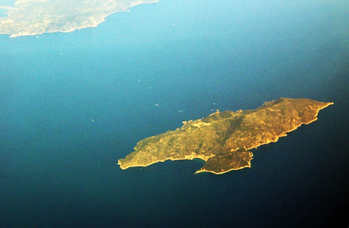
Giglio Island, Italy off the coastline of Tuscany - Location Costa Concordia Shipwreck
Click to enlarge
Rescues divers have used explosives to gain entry to portions of the ship searching for any survivors.
Rescue efforts were temporarily suspended today (Jan. 18) due to rough seas. The Costa Concordia is loaded with several thousand gallons of diesel fuel oil which could contaminate the surroundings.
Satellite Close-up of Wreckage of Costa Concordia Luxury Cruise Ship of the coast of Giglio, Italy. Credit: DIGITALGLOBE
According to the DigitalGlobe website, the Colorado based company owns and operates the most sophisticated constellation of high-resolution commercial earth imaging satellites – . QuickBird, WorldView-1 and WorldView-2 which are capable of collecting over 500 million km2 of quality imagery per year with high resolution cameras.
The DigitalGlobe satellites are used for defense and intelligence, civil agencies, mapping and analysis, environmental monitoring and oil and gas exploration.
Costa Concordia Shipwreck
Artist concept shows DigitalGlobe Quickbird satellite soaring over Italy and Sicily. Credit: DigitalGlobe
Merapi Volcano on November 10, 2010, when the Moderate Resolution Imaging Spectroradiometer (MODIS) on NASA’s Terra satellite. Credit: NASA
[/caption]
For about three weeks, Indonesia’s Mount Merapi has been belching out lava, as well as ash and gas, clouding the atmosphere above. This satellite image, taken by NASA’s MODIS instrument on the Terra satellite, shows the volcano now settling down and is the most cloud-free satellite view of the volcano that we’ve been able to see. Thick ash is still rising and the volcano is still considered to be erupting at dangerous levels. Merapi is one of Indonesia’s most active volcanoes, and this eruption has been the most violent since the 1870’s.
The dark brown streak down the southern face of the volcano is ash and other volcanic material deposited by a pyroclastic flow or lahar. The volcano has been blamed for 156 deaths and about 200,000 people had to evacuate. The ash also caused flights to be delayed or canceled.
See below for a thermal image of the lava flow.
The Advanced Spaceborne Thermal Emission and Reflection Radiometer (ASTER) on NASA’s Terra satellite captured the thermal signature of hot ash and rock and a glowing lava dome on Mount Merapi on Nov. 1, 2010. Credit: NASA.
As a very active volcano, Merapi poses a constant threat to thousands of people in Indonesia. The Advanced Spaceborne Thermal Emission and Reflection Radiometer (ASTER) on NASA’s Terra satellite captured the thermal signature of hot ash and rock and a glowing lava dome. The thermal data is overlaid on a three-dimensional map of the volcano to show the approximate location of the flow. The three-dimensional data is from a global topographic model created using ASTER stereo observations.
For more information see NASA’s Earth Observatory website.


 on NASA’s Terra satellite captured the thermal signature of hot ash and rock and a glowing lava dome on Mount Merapi on Nov. 1, 2010. Credit: NASA.")