Sentinel-1 Satellites Confirm San Francisco’s Millenium Tower Is Sinking

The Millennium Tower luxury skyscraper in San Francisco is sinking and tilting. Image by MichaelTG - Own work, CC BY-SA 4.0, https://commons.wikimedia.org/w/index.php?curid=51657571

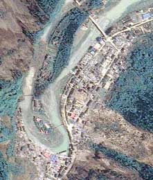
The Millennium Tower is a luxury skyscraper in San Francisco. It has been sinking and tilting since it’s construction 8 years ago. In fact, the 58 story building has sunk 8 inches, and tilted at least 2 inches. San Francisco is experiencing a building boom, and planners and politicians want to know why the Millennium Tower is having these problems.

Now they’re getting a little help from space.

The European Space Agency’s (ESA) Copernicus Sentinel-1 satellites have trained their radar on San Francisco. They’ve found that the Millennium Tower is sinking, or subsiding, at the alarming rate of almost 50 mm per year. Although the exact cause is not yet known for sure, it’s suspected that the building’s supporting piles are not resting on solid bedrock.

An artist's illustration of the Sentinel-1. Image: ESA/ATG Medialab
An artist’s illustration of the Sentinel-1. Image: ESA/ATG Medialab

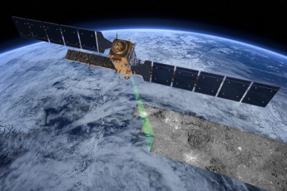
The Sentinel-1 satellites are part of the ESA’s Copernicus Program. There are two of the satellites in operation, and two more are on the way. They employ Synthetic Aperture Radar to provide continuous imagery during the day, during the night, and through any kind of weather.

The satellites have several applications:

  • Monitoring sea ice in the arctic
  • Monitoring the arctic environment and other marine environments
  • Monitoring land surface motion
  • Mapping land surfaces, including forest, water, and soil
  • Mapping in support of humanitarian aid in crisis situations

Though the Sentinels were not specifically designed to monitor buildings, they’re actually pretty good at it. Buildings like the Millennium Tower are especially good at reflecting radar. When multiple passes are made with the satellites, they provide a very accurate measurement of ground subsidence.

Radar data from Sentinel-1 shows the displacement in San Francisco's Bay Area. Yellow-red areas are sinking, while blue areas are rising. Green areas are not moving. Image: ESA SEOM INSARAP study / PPO.labs / Norut / NGU
Radar data from Sentinel-1 shows the displacement in San Francisco’s Bay Area. Yellow-red areas are sinking, while blue areas are rising. Green areas are not moving. Image: ESA SEOM INSARAP study / PPO.labs / Norut / NGU

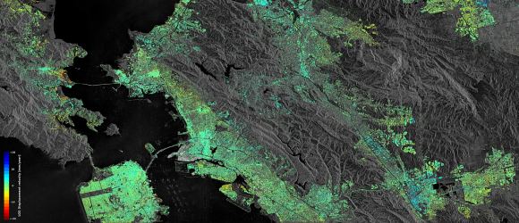
The Millennium Tower is not the only thing in San Francisco Bay Area that Sentinel-1 can see moving. It’s also spotted movement in buildings along the Hayward Fault, an area prone to earthquakes, and the sinking of reclaimed land in San Rafael Bay. It’s also spotted some rising land near the city of Pleasanton. The recent replenishing of groundwater is thought to be the cause of the rising land.

Now other parts of the world, especially in Europe, are poised to benefit from Sentinel-1’s newfound prowess at reading the ground. In Oslo, Norway, the train station is built on reclaimed land. Newer buildings have proper foundations right on solid bedrock, but the older parts of the station are experiencing severe subsidence.

Sentinel-1 data shows that the Oslo train station, the red/yellow area in the center of the image, is sinking at the rate of 12-18mm per year. Image:  Copernicus Sentinel data (2014–16) / ESA SEOM INSARAP study / InSAR Norway project / NGU / Norut / PPO.labs
Sentinel-1 data shows that the Oslo train station, the red/yellow area in the center of the image, is sinking at the rate of 12-18mm per year. Image: Copernicus Sentinel data (2014–16) / ESA SEOM INSARAP study / InSAR Norway project / NGU / Norut / PPO.labs

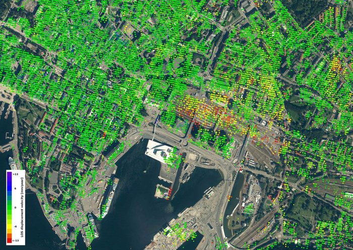
John Dehls is from the Geological Survey of Norway. He had this to say about Sentinel: “Experience and knowledge gained within the ESA’s Scientific Exploitation of Operational Missions programme give us strong confidence that Sentinel-1 will be a highly versatile and reliable platform for operational deformation monitoring in Norway, and worldwide.”

As for the Millennium Tower in San Francisco, the problems continue. The developer of the building is blaming the problems on the construction of a new transit center for the city. But the agency in charge of that, the Transbay Joint Powers Authority, denies that they are at fault. They blame the developer’s poor structural design, saying that it’s not properly built on bedrock.

Now, the whole thing is before the courts. A $500 million class-action lawsuit has been filed on behalf of the residents, against the developer, the transit authority, and other parties.

It’s a good bet that data from the Sentinel satellites will be part of the evidence in that lawsuit.

Famous Earthquakes

Earthquakes are among the most devastating forces of nature. What we have are seven of the world’s most famous earthquakes, chronologically listed below. Not all included here are necessarily the strongest (in terms of magnitude) but they made the headlines when they hit. Here they are:

Shaanxi Earthquake of 1556

– This was the deadliest quake ever recorded. It claimed the lives of about 830,000 people. At that time, most inhabitants in the affected areas were living in Yaodongs or artificial caves. They were buried alive when the huge tremors caused the cliffs in which these caves were located in, to collapse.

San Francisco Earthquake of 1906

– Although its tremors were also felt in Southern Oregon, it is the resulting fire in San Francisco that had a more devastating impact on the economy. Is has been often compared recently to Hurricane Katrina because of its similar economic bearing.

The Great Chilean Earthquake of 1960

– Like the one that hit Asia in 2004, this 9.5-rated quake resulted in a massive tsunami reaching up to as high as 10.7 meters. This magnitude is the highest recorded ever. Although the tsunami originated in Cañete, Chile, the waves raced north-westward to Japan and the Philippines, wreaking havoc there.

Great Alaska Earthquake of 1964

– With a magnitude of 9.2, it is the second strongest earthquake to be ever recorded. It caused tsunamis, landslides, and resulted in major landscape changes. Some places near Kodiak is said to have been raised 9.1 meters high, while those near Portage were dropped by 2.4 meters. Here are more articles about Alaska earthquakes.

Great Tangshan Earthquake of 1976

– This is the deadliest quake of the 20th Century, with the number of deaths hitting somewhere near 250,000. Weak building structures and the time this disaster struck (4 am) contributed a lot to that sickening number.

Bam Earthquake of 2003

– The death toll in this tremor reached over 26,000. Like the one in Tangshan, the use of poor construction materials was one of the leading culprits for the deaths. Most of the affected buildings were made of mud bricks.

Indian Ocean Earthquake of 2004

– The resulting tsunami that killed 230,000 people was caused by a subduction between the India and Burma plate. Its 30 m-high waves destroyed virtually everything in its path, making this quake not only one of the most famous earthquakes but also one of the famous natural disasters in history.

Excluding poor building infrastructure, we can see that high death tolls in these famous earthquakes result when the tremors are accompanied by tsunamis. This happens when the quake’s epicenter is found at the bottom of the ocean.

You can read more about famous earthqueakes here in Universe Today. Here are the links:

There’s more about it at USGS. Here are a couple of sources there:

Here are two episodes at Astronomy Cast that you might want to check out as well:

Sources:
http://en.wikipedia.org/wiki/1906_San_Francisco_earthquake
http://en.wikipedia.org/wiki/2006_Hawaii_earthquake
http://en.wikipedia.org/wiki/1556_Shaanxi_earthquake
http://earthquake.usgs.gov/earthquakes/world/events/1960_05_22.php
http://en.wikipedia.org/wiki/1964_Alaska_earthquake
http://en.wikipedia.org/wiki/1976_Tangshan_earthquake
http://en.wikipedia.org/wiki/2003_Bam_earthquake
http://en.wikipedia.org/wiki/2004_Indian_Ocean_earthquake_and_tsunami