What Curiosity Looks Like From 200 Kilometers Up

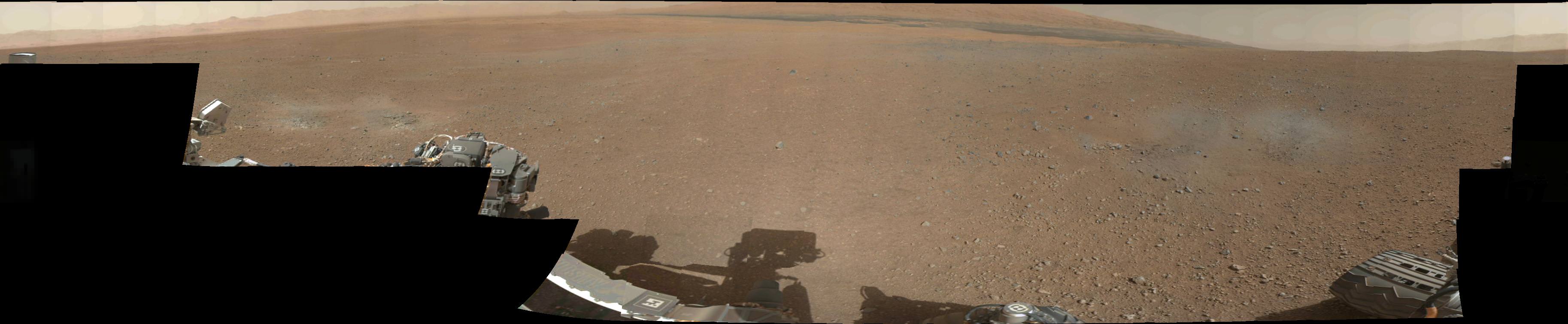
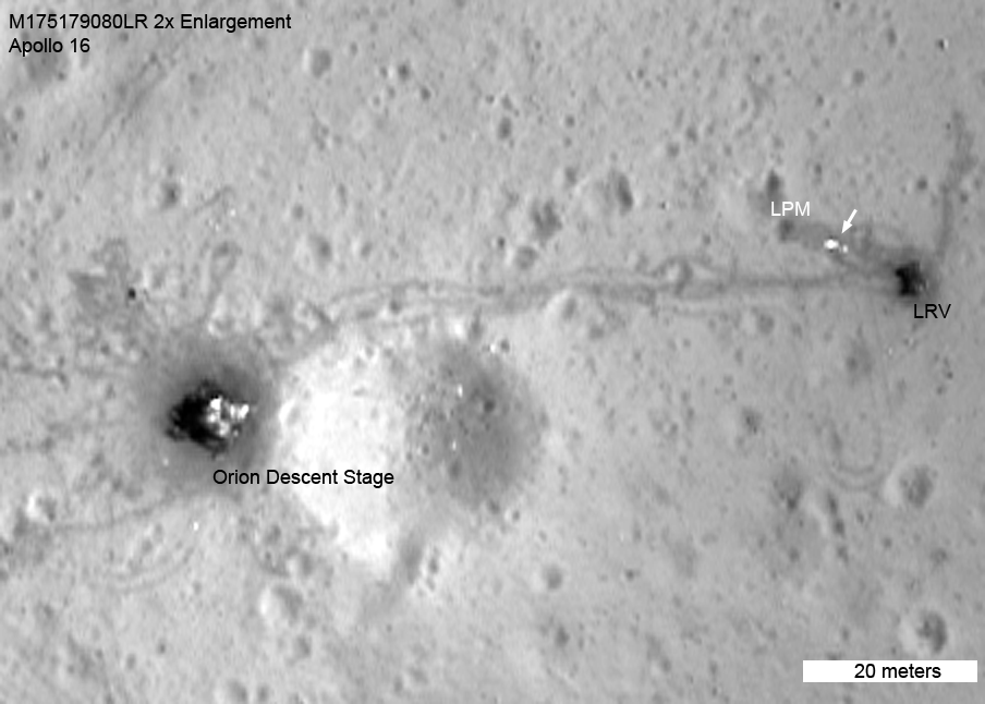
Here’s a look down at Curiosity from the HiRISE camera aboard NASA’s Mars Reconnaissance Orbiter, orbiting approximately  200 km (125 miles) above the surface of Mars. This new image, released today, shows the rover inside Gale Crater surrounded by a skirt of blue-tinted material, including several bright radiating marks –the  result of the descent stage rockets clearing layers of dust from the surface.

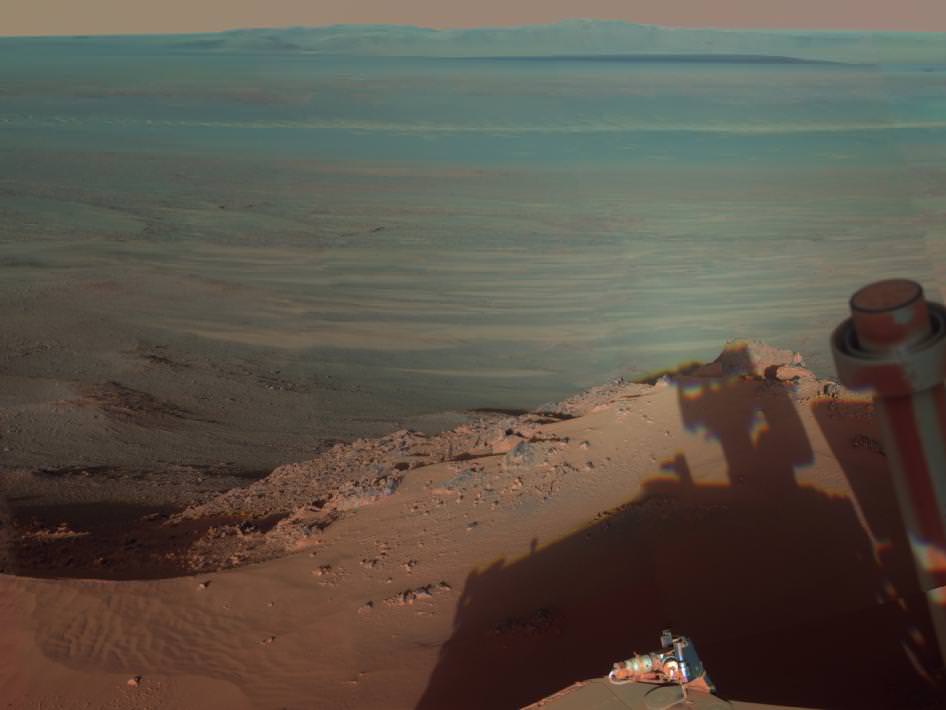
In this exaggerated-color view the blue indicates material of a different texture and composition than the surrounding area. HiRISE captures images in visible light wavelengths as well as near-infrared, which we can’t see. To us, the blue material would look grey.

North is up, and Curiosity’s ultimate exploration target, Gale Crater’s central peak, Mount Sharp, is off frame to the lower right.

Click here for a full-size version of the HiRISE image scan, showing the scene above plus some areas further north and south — including portions of the dark dune fields visible in recent images from Curiosity.

It’s nice to know that Curiosity has friends in high places!

Image: NASA/JPL/University of Arizona


Curiosity’s First 360-Degree Color Panorama

Doesn’t Gale Crater look lovely this time of year? This is the first 360-degree panorama of color images taken by Curiosity’s color Mast Camera. The individual images used in this first panorama may only have been thumbnail-sized, but the effect is no less stunning.

(Click the image to panoramify.)

 The images were acquired on August 9 EDT. Although taken during late afternoon at Gale crater, the individual images still had to be brightened as Mars only receives half the amount of sunlight that Earth does.

Full-size 1200×1200 pixel images will be available at a later date.

The two grey patches in the foreground at left and right are the result of Curiosty’s sky crane rockets blasting the Martian surface. Scientists will be investigating these areas as they expose material that was previously hidden beneath Mars’ red dust.

The base of Gale Crater’s 3.4-mile (5.5 km) high central peak, named Mt. Sharp in honor of planetary science pioneer Robert P. Sharp, can be seen in the distance at center. (Check out an oblique view of a portion of Mt. Sharp acquired by HiRISE camera here.)

You can play with an interactive 360-degree panorama at the NASATech website, put together by John O’Connor, and if you look closely, visible is the full JPL logo on the middle right wheel — in Morse Code!

As always, you can find more news from the MSL mission here.

Image: NASA/JPL-Caltech

A Panorama of Curiosity’s Surroundings

Taken this morning (mission Sol 2) with the rover’s left Navcam, here’s a high-res panorama of Curiosity’s view at its landing site within Gale crater. The wide-angle view was assembled from two separate raw images, so while the mountainous rim of the crater is lined up horizontally there’s some distortion in alignment of objects closer to the rover due to the angle of the Navcam lens. Still, it’s a very cool view of Curiosity’s surroundings!

See the latest images from the MSL mission here, and check out 3D anaglyph images from Curiosity here.

Image: NASA/JPL-Caltech. Edited by J. Major.

(Image updated to link to full-size version.)

Will Curiosity Look for Life on Mars? Not Exactly…

“Curiosity is not a life detection mission. We’re not actually looking for life and we don’t have the ability to detect life if it was there. What we are looking for is the ingredients of life.”
– John Grotzinger, MSL Project Scientist

And with these words this latest video from NASA’s Jet Propulsion Laboratory begins, explaining what Curiosity’s goal will be once it arrives on Mars on August 5. There will be a lot of media coverage of the event and many news stories as the date approaches, and some of these will undoubtedly refer to Mars Science Laboratory as a “search for life on Mars” mission… but in reality the focus of MSL is a bit subtler than that (if no less exciting.)

But hey, one can always dream

Video: NASA/JPL

Kickstart Your DNA (And a Rover) To The Moon!


Omega Envoy, the non-profit research lab Earthrise Space, Inc.’s team competing for the Google Lunar X PRIZE, has launched a Kickstarter project to help fund a 4-axis CNC milling machine needed to continue development on their proposed lunar rover. CNC machines don’t come cheap, but in typical Kickstarter fashion Earthrise Space is offering incremental rewards to anyone who donates to their project — from mentions on their site to t-shirts, Moon globes and facility tours (and even 5-gallon tubs of duck sauce) and, if you’re lucky enough to have deep pockets and a desire to help a student training ground get their designs off the ground, you can even have your DNA sent to the Moon!

From the Google Lunar X PRIZE article:

For the first time in human history, individuals will have the opportunity to send a sample of their DNA to the lunar surface. For a pledged donation of $10,000 or more, ESI will collect your DNA sample, package it into a storage container mounted on the company’s Lunar Descent Vehicle and fly it to the surface of the moon where it will be preserved for all time.

“We are excited to be exploring new approaches for fundraising and for public engagement, including through the crowdsourcing Kickstarter platform,” said ESI’s Chief Operating Officer (COO) Joseph Palaia. “We are hopeful that this Kickstarter project helps us to make significant progress towards our near-term fundraising goals, while also providing some incredible rewards for our supporters.”

With the Google Lunar X PRIZE, a total of $30 million in prize money is available to the first privately funded team to safely land a robot on the surface of the Moon, have that robot travel 500 meters over the surface, and send HD video, images and data back to Earth.

Of the 26 teams in the competition, ESI is one of only six teams which have been selected for a NASA Innovative Lunar Demonstrations Data contract worth up to $10M. But the contract is awarded incrementally and a multi-axis CNC machine is needed to take their designs to the next level (and meet upcoming contract goals.) Donate to their Kickstarter project here.

At whatever level you contribute, know that you are helping students build real spacecraft, and you’re going to be getting some pretty amazing rewards as well! The students appreciate your support!

— Omega Envoy team, ESI

Find out more about ESI’s project on the Earthrise Space Inc. website, and check out the other Google Lunar X PRIZE competitors here.

Source: Google Lunar X PRIZE blog

Opportunity Gets a View From The Edge

Opportunity's shadow aims eastward to the rim of Endeavour crater

[/caption]

The rover Opportunity captured a view into Endeavour crater as a low Sun cast a long shadow in this image, acquired back on March 9.

Endeavour is a large crater — 14 miles (22 km) wide, it’s about the same area as the city of Seattle. Opportunity arrived at its edge in August of 2011 after several years of driving across the Meridiani Plains.

Opportunity is currently the only operational manmade object on the surface of Mars… or any other planet besides Earth, for that matter. It’s a distinction it will hold until the arrival of Mars Science Laboratory at Gale Crater this August.

From the NASA news release by JPL’s Guy Webster:

The scene is presented in false color to emphasize differences in materials such as dark dunes on the crater floor. This gives portions of the image an aqua tint.

Opportunity took most of the component images on March 9, 2012, while the solar-powered rover was spending several weeks at one location to preserve energy during the Martian winter. It has since resumed driving and is currently investigating a patch of windblown Martian dust near its winter haven.

Opportunity and its rover twin, Spirit, completed their three-month prime missions on Mars in April 2004. Both rovers continued for years of bonus, extended missions. Both have made important discoveries about wet environments on ancient Mars that may have been favorable for supporting microbial life. Spirit stopped communicating in 2010. Since landing in the Meridiani region of Mars in January 2004, Opportunity has driven 21.4 miles (34.4 kilometers).

Image credit: NASA/JPL-Caltech/Cornell/Arizona State University

Lunar Satellite Reveals Apollo 16 Remains

LROC image of the Apollo 16 site showing the Orion LM. (NASA/GSFC/Arizona State University)


NASA’s Lunar Reconnaissance Orbiter (LRO) made a low pass over the Apollo 16 site last fall, capturing images of the leftovers from John Young and Charlie Duke’s 1972 exploration of the Descartes Highlands. The video above takes us on a tour of the Apollo 16 site from lunar orbit, and includes audio from the original communications and some very nice comparative photos and video clips showing the same features from ground level.

The goal of Apollo 16 was to explore for the first time a lunar highlands location, and collect samples of what were initially thought to be volcanic rocks. The rocks were believed to be of a different material than what was collected during previous missions.

As it turned out, the rocks collected by Duke and Young weren’t volcanic in origin at all; they ended up being breccias — cemented-together chunks ejected from ancient cratering events hundreds of miles away.

Apollo 16 also set up various experiment packages to study lunar geology, magnetism and the solar wind. The Lunar Roving Vehicle (LRV) allowed Young and Duke to travel across a much wider area than they would have otherwise been able to on foot. It was the second mission to use an LRV, and the rover — as well as its tracks — are still there today, looking exactly as they did when they were left 40 years ago.

[/caption]

The Apollo 16 ascent stage lifted off from the lunar surface on the evening of April 23, 1972 and docked with the Command Module containing Ken Mattingly. The following day the astronauts began their trip back to Earth, completing the 250,000-mile traverse three days later on April 27.

The Moon would be visited again in December of that same year during Apollo 17, the last mission of the program and the last time that humans would walk on the surface of another world. Now, 40 years later, satellites orbiting the Moon take pictures of what was left behind by these historic events. Perhaps someday soon the sites will be visited from ground level… maybe even by a new generation of astronauts.

Panorama of the Descartes Highlands site made from 3 Hasselblad film image scans combined together. (NASA/JSC/J. Major)

Read more about this on Arizona State University’s LROC site, and explore the full-frame Narrow-Angle Camera image from the LROC here.

Video: NASA/GSFC/Arizona State University

Revisiting The First Rover

LROC image of Lunokhod 1 (NASA/GSFC/ASU)

[/caption]

Before there was Curiosity, before Spirit, and Opportunity, and even long before Sojourner, there was Lunokhod 1, the Soviet Union’s lunar rover that explored Mare Imbrium from November of 1970 to September the following year. It was a curious-looking machine, a steampunk fantasy reminiscent of something out of a Jules Verne novel. But until the Mars Exploration Rovers nearly 40 years later, Lunokhod 1 held the record for the longest-operating robotic rover on the surface of another world.

These images from the Lunar Reconnaissance Orbiter Camera (LROC) are the most detailed yet of the now-silent Soviet rover and its lander, Luna 17.

The lander, Luna 17, was launched from Earth orbit on November 10, 1970, and entered lunar orbit five days later. It successfully soft-landed in Mare Imbrium on November 17 and deployed the Lunokhod (“moon walker” in Russian) rover, which was powered by batteries that were recharged via solar power during the lunar day.

Luna 17 and Lunokhod 1's tracks. (NASA/GSFC/ASU)

The 5600 kg (12,345 lb.) Lunokhod 1 boasted a suite of scientific tools for exploring the lunar surface. It was equipped with a cone-shaped antenna, a highly directional helical antenna, four television cameras, and special extendable devices to impact the lunar soil for soil density and mechanical property tests.

An x-ray spectrometer, an x-ray telescope, cosmic-ray detectors, and a laser device were also included.

The super-steampunk Lunokhod 1 rover. (NASA/GSFC)

Operating for nearly 300 days — almost four times longer than planned — by the time it officially ceased operations in October 1971 Lunokhod 1 had traveled 10,540 meters and had transmitted more than 20,000 images, and had conducted over 500 lunar soil tests.

The images above were obtained during a low-altitude pass by LRO, which came within 33 km (20.5 miles) of the lunar surface.

Via the LROC site by Arizona State University.

Luna 17 seen from Lunokhod 1

Interview and tour with GLXP team Omega Envoy – SpacePod 2011.05.30

Spacevidcast’s Jason Rhian had a chance to go behind the scenes with the Google Lunar X PRIZE team Omega Envoy to take a peek at their new facility and the progress of their lunar rover. Omega Envoy is one of nearly 30 teams competing to win part of the $30 million dollar pot for sending a rover to the moon and completing specific tasks.
Continue reading “Interview and tour with GLXP team Omega Envoy – SpacePod 2011.05.30”