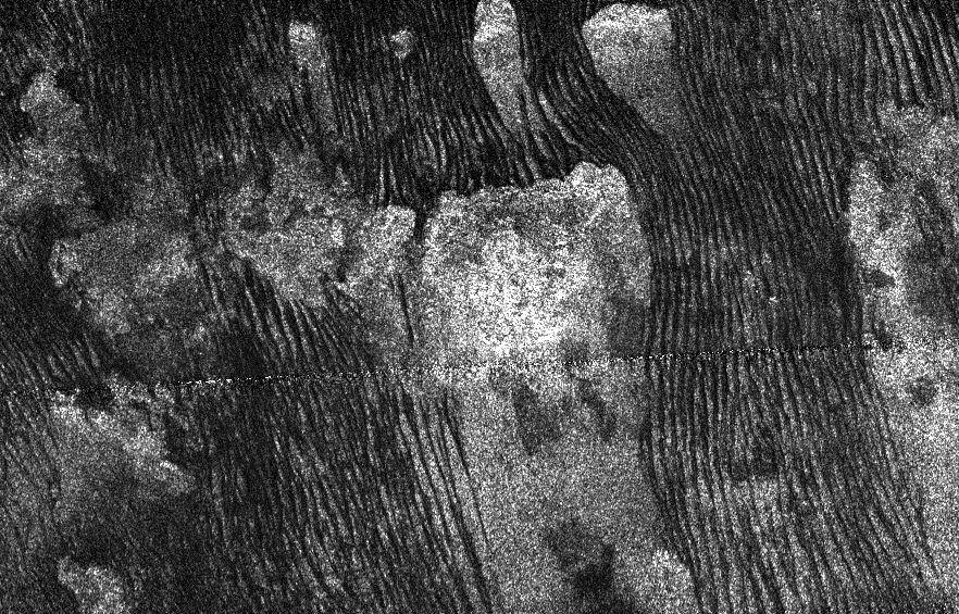
Radar image of rows of dunes on Titan. Credit: NASA/JPL-Caltech
Looking like the flowing designs carved by a Zen gardener’s rake, long parallel dunes of hydrocarbon sand stretch across the surface of Saturn’s moon Titan. The image above, acquired by Cassini in July 2013, reveals these intriguing and remarkably Earthlike landforms in unprecedented detail via radar, which can easily pierce through Titan’s thick clouds.
I’m feeling a little more enlightened already.
Although it piles into dunes like sand does here, Titan’s sand is not the same as what you’d find on a beach here on Earth. According to an ESA “Space in Images” article:
While our sand is composed of silicates, the ‘sand’ of these alien dunes is formed from grains of organic materials about the same size as particles of our beach sand. The small size and smoothness of these grains means that the flowing lines carved into the dunes show up as dark to the human eye.
Titan’s surface is almost completely hidden from view by its thick orange “smog” (NASA/JPL-Caltech/SSI. Composite by J. Major)
Radar imaging, although capable of seeing through Titan’s opaque orange atmosphere, doesn’t capture visible-light images. Instead it’s sensitive to the varying textures of a landscape as they reflect microwaves; the smoother an object or an area is the darker it appears to radar, while irregular, rugged terrain shows up radar-bright.
The pixelated “seam” cutting horizontally across the center is the result of image artifacting.
A 25-acre sinkhole near Bayou Corne, Louisiana that formed in Aug. 2012. In 2014, a new analysis of NASA radar data found that the sinkhole was evident in that information before its collapse. Credit: On Wings of Care, New Orleans, La.
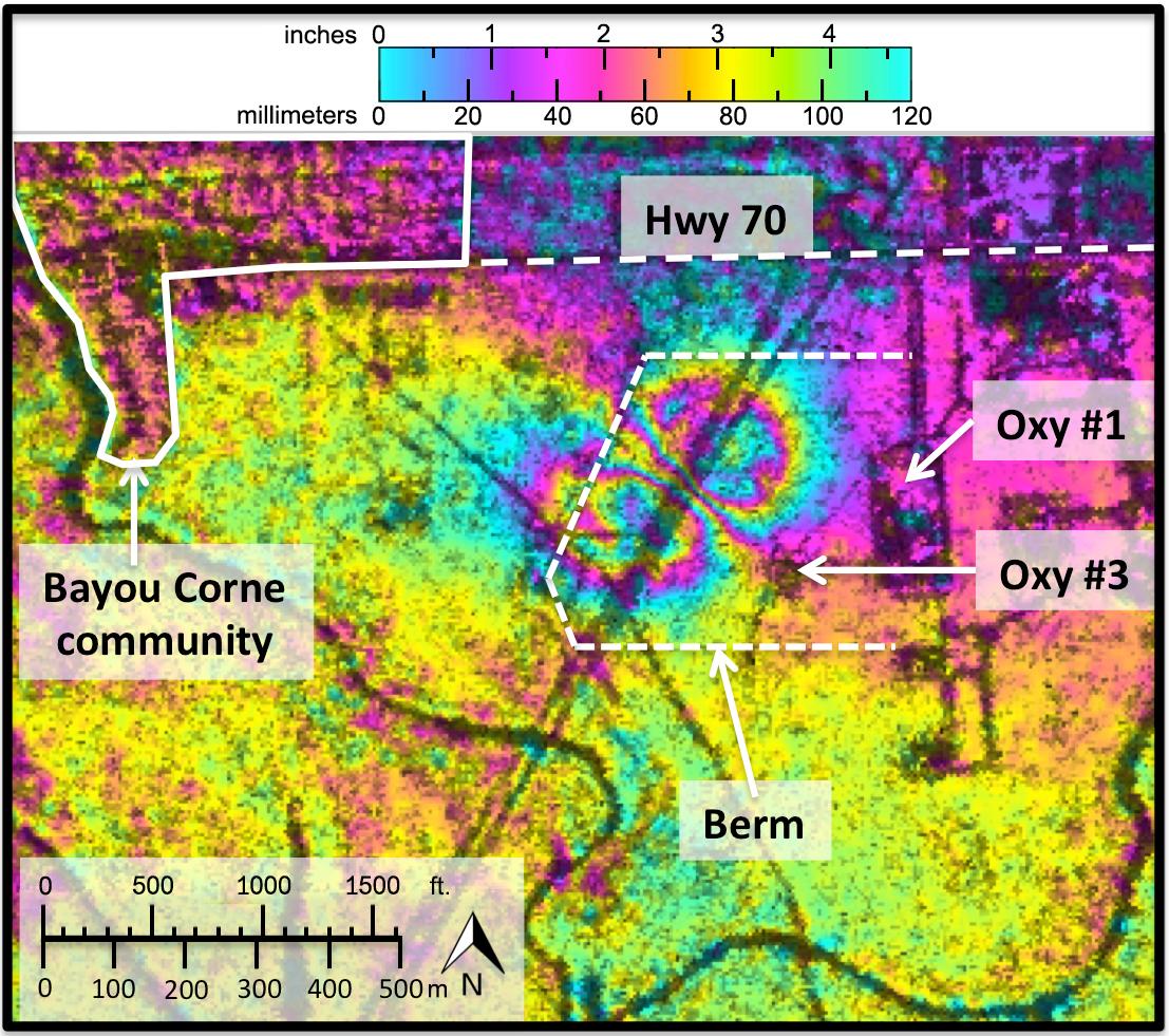
A Louisiana sinkhole the size of 19 American football fields shifted sideways in radar measurements before its collapse and resulting evacuations in 2012, a study reveals.
The implication is that if certain types of radar measurements are collected regularly from above, it is possible to see some sinkholes before they collapse. The researchers added, however, that their discovery was “serendipitous” and there are no plans to immediately use a NASA robotic Gulfstream plane used for the study to fly over spots that could be vulnerable to sinkholes.
Data showed the ground near Bayou Corne moving horizontally up to 10.2 inches (26 centimeters) toward where the sinkhole appeared suddenly in August 2012. The hole started out at about 2 acres of size (1 hectare) — an area smaller than the initial ground movements — and now measures about 25 acres (10 hectares).
The research was published in the journal Geology in February, and was first made available online in December. NASA highlighted the information in a press release published in early March.
“While horizontal surface deformations had not previously been considered a signature of sinkholes, the new study shows they can precede sinkhole formation well in advance,” stated Cathleen Jones, leader of the research and a part of NASA’s Jet Propulsion Laboratory in California.
Regions and rock types of the United States that could be vulnerable to sinkholes. Credit: U.S. Geological Survey
“This kind of movement may be more common than previously thought, particularly in areas with loose soil near the surface.”
Jones and her NASA JPL colleague, Blom, found the information in NASA’s interferometric synthetic aperture radar (inSAR), which flew over the region in June 2011 and July 2012 on the agency’s Uninhabitated Aerial Vehicle Synthetic Aperture Radar. The radar can see shifts in the Earth’s surface.
The sinkhole — which is full of water and ground-up solids and is still getting bigger — collapsed after several small earthquakes and after the community became aware of “bubbling natural gas” in the area, NASA stated.
A sinkhole threatens the nearby community of Bayou Corne, Louisiana in this image released on NASA’s website in March 2014. Credit: NASA/JPL-Caltech
“It was caused by the collapse of a sidewall of an underground storage cavity connected to a nearby well operated by Texas Brine Company and owned by Occidental Petroleum,” the agency added.
“On-site investigation revealed the storage cavity, located more than 3,000 feet (914 meters) underground, had been mined closer to the edge of the subterranean Napoleonville salt dome than thought.” (A salt dome is a location in sedimentary rocks where salt is pushed up beneath the surface.)
Measurements of the area were taken as recently as October 2013, as the growing sinkhole is threatening the nearby community as well as a highway in the region.
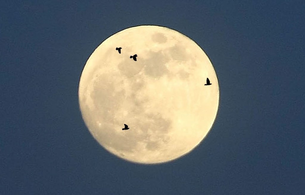
The moon provides the perfect backdrop for watching birds migrate at night. Observers with spotting scopes and small telescopes can watch the show anytime the moon is at or near full. Photo illustration: Bob King
Tonight’s the Harvest Moon, the full Moon closest to the fall equinox. A perfect time to catch a big orange Moon on the horizon AND the annual fall bird migration. Every September and October anyone with a small telescope or spotting scope magnifying 30x can enjoy the sight of one bird after another flying over the cratered lunar landscape. It’s so easy.
Point your telescope at the Moon and watch for dark silhouettes to flutter across its face. Because the angle of the full Moon’s path to the horizon is very shallow in September and October, the time difference between successive moonrises is only about 20-30 minutes instead of the usual 50-60. That means you’ll catch both moonlight and bird flight on successive nights without having to stay up late.
The Harvest Moon rises over Lake Superior in Duluth, Minn last September. When you’re out moon and birdwatching, look for the dark band below the rising moon. That’s the Earth’s shadow. It’s visible for about 15-20 after sunset and topped by the pink-tinged “Belt of Venus”, where the atmosphere is still reflecting reddened sunlight. Credit: Bob King
Many birds migrate at night both because it’s cooler and to avoid predators that could otherwise pick them off in a daylight run. Identifying the many warblers, blackbirds, sparrows, vireos, orioles and other species that fly across the moon while we sleep may be next to impossible for anyone but an expert, but seeing them is easy. Two night ago for fun, I counted a dozen birds in the five-minute interval around 10 o’clock through my 10-inch telescope at low power (76x). Assuming they continued to fly by at a steady rate, I could potentially have spotted 144 birds in just an hour’s time.
Two of my favorite migrating birds: the winter wren (left) and chestnut-sided warbler. Credit: Bob King
As you might suspect, most of those birds crossed the Moon from north to south (about two-thirds) with the other third traveling either east to west or northeast to southwest. Only one little silhouette flapped back up north in the ‘wrong’ direction.
According to the Chipper Woods Bird Observatory, located in Indianapolis, most nighttime migrators begin their flight right after sunset and continue until about 2 a.m. Peak time is between 11 p.m. and 1 a.m. Bird typically migrate at altitudes ranging from 1,500 to 5,000 feet, but on some nights, altitudes may range from 6,000 and 9,000 feet. I could tell the high ones from the low ones by their size and sharpness. Nearby birds flew by out of focus, while distant ones were sharply defined and took longer to cross the moon.
Check out this animation showing a wave of bird migration after sunset on Aug. 27 made with NEXRAD. Birds are visible funneling down both shores of Lake Superior and moving south of Duluth, Minn (city at center). Credit: NWS
While birders may continue to use the moon night birding, they now have a new tool – NEXRAD or NEXt-generation of Weather RADar. About 150 NEXRAD sites were set up in the 1990s to track weather and storm systems across the U.S. When precipitation gets pinged by the radar’s pulse it reflects back a signal that identifies it as rain, snow or whatever. Included in the information is the material’s speed and direction of travel. NEXRAD works equally well on meteorite falls, birds and even insects. While storm activity typically shows up as familiar blotches of yellow, orange and red, birds appear as fine stipplings. By compiling NEXRAD loops, during particularly heavy migration times, you can actually watch swarms of birds wing their way south. Click HERE for a map of all U.S. NEXRAD locations, each of which links to current radar maps.
On the less technological side, watching birds pass across the Moon in a small telescope is a very pleasant activity reminiscent of meteor shower watching. At first you see nothing, then blip! a bird (meteor) flies by. You wait another minute and then suddenly two more appear in tandem. Both activities give you that delicious sense of anticipation of what the next moment might hold.
The best time to watch the nighttime avian exodus is around full Moon, when the big, round disk offers an ideal spotlight on the birds’ behavior, but anytime between waxing and waning gibbous phase will work. It’s an enchanting sight to see Earth’s creatures streak across an alien landscape, and another instance of how a distant celestial body “touches” Earth in unexpected ways.
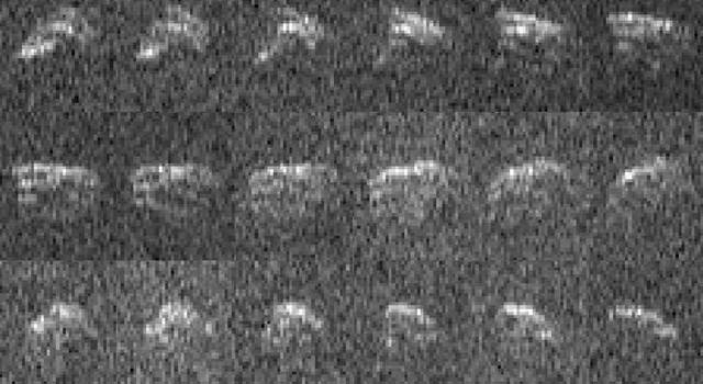
Radar images of asteroid 1998 QE2 and its satellite on June 7. Each frame in the animation is a sum of 4 images, spaced apart by about 10 minutes. (Arecibo Observatory/NASA/Ellen Howell)
On the last day of May 2013 asteroid 1998 QE2 passed relatively closely by our planet, coming within 6 million kilometers… about 15 times the distance to the Moon. While there was never any chance of an impact by the 3 km-wide asteroid and its surprise 750 meter satellite, astronomers didn’t miss out on the chance to observe the visiting duo as they soared past as it was a prime opportunity to learn more about two unfamiliar members of the Solar System.
By bouncing radar waves off 1998 QE2 from the giant dish at the Arecibo Observatory in Puerto Rico, researchers were able to construct visible images of the asteroid and its ocean-liner-sized moon, as well as obtain spectrum data from NASA’s infrared telescope in Hawaii. What they discovered was quite surprising: QE2 is nothing like any asteroid ever seen near Earth.
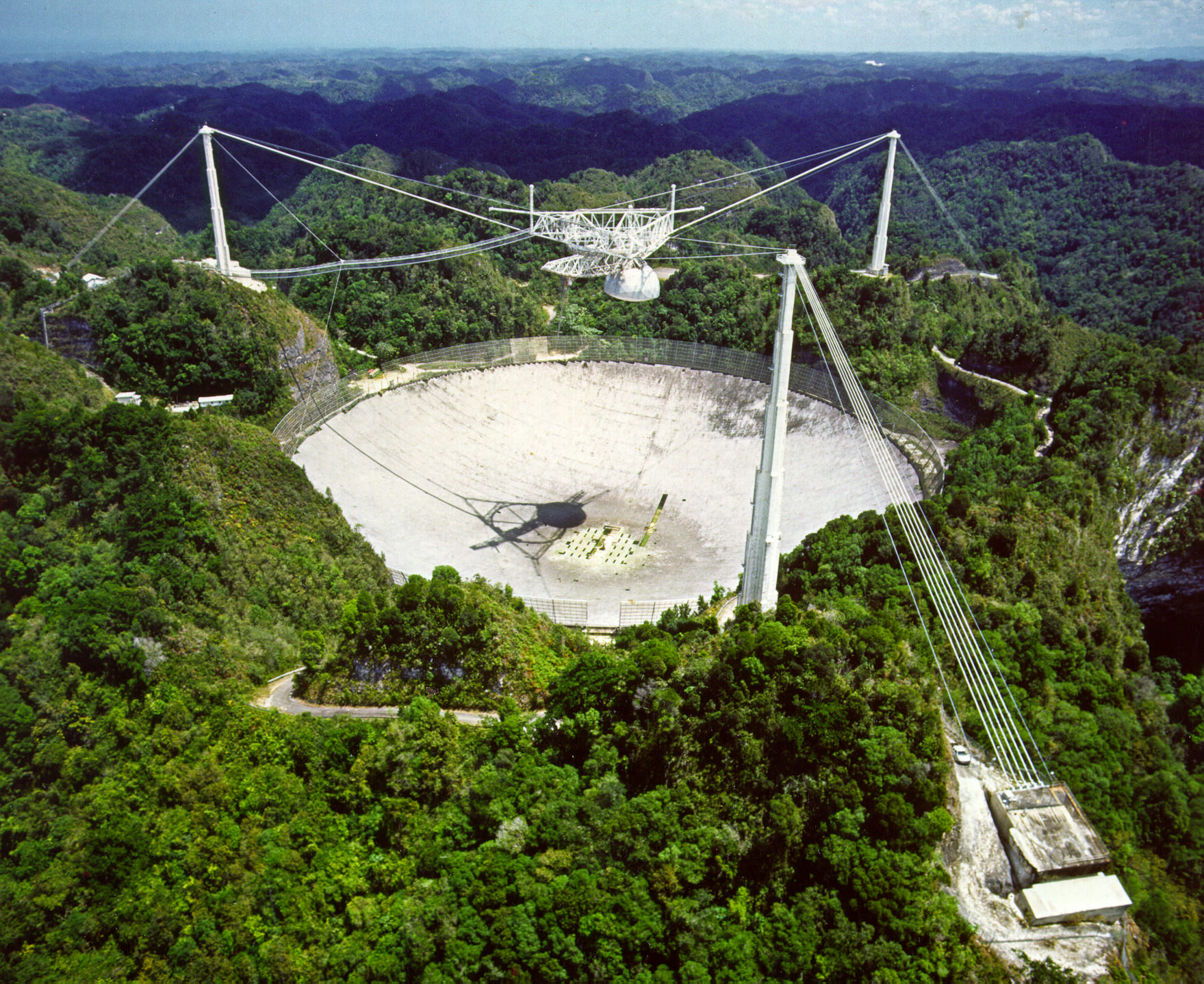
The 305-meter dish at Arecibo Observatory in Puerto Rico (Image courtesy of the NAIC – Arecibo Observatory, a facility of the NSF)
Both Arecibo Observatory and NASA’s Goldstone Deep Space Communications Complex in California are unique among telescopes on Earth for their ability to resolve features on asteroids when optical telescopes on the ground merely see them as simple points of light. Sensitive radio receivers collect radio signals reflected from the asteroids, and computers turn the radio echoes into images that show features such as craters and, in 1998 QE2’s case, a small orbiting moon.
QE2’s moon appears brighter than the asteroid as it is rotating more slowly; thus its Doppler echoes compress along the Doppler axis of the image and appear stronger.
Of the asteroids that come close to Earth approximately one out of six have moons. Dr. Patrick Taylor, a USRA research astronomer at Arecibo, remarked that “QE2’s moon is roughly one-quarter the size of the main asteroid,” which itself is a lumpy, battered world.
Dr. Taylor also noted that our own Moon is a quarter the size of Earth.
QE2’s moon will help scientists determine the mass of the main asteroid and what minerals make up the asteroid-moon system. “Being able to determine its mass from the moon helps us understand better the asteroid’s material,” said Dr. Ellen Howell, a USRA research astronomer at Arecibo Observatory who took both radar images of the asteroid at Arecibo and optical and infrared images using the Infrared Telescope Facility in Hawaii. While the optical images do not show detail of the asteroid’s surface, like the radar images do, instead they allow for measurements of what it is made of.
“What makes this asteroid so interesting, aside from being an excellent target for radar imaging,” Howell said, “is the color and small moon.”
Radar images of asteroid 1998 QE2 and its satellite (top) on June 6. (Arecibo Observatory/NASA/Ellen Howell)
“Asteroid QE2 is dark, red, and primitive – that is, it hasn’t been heated or melted as much as other asteroids,” continued Howell. “QE2 is nothing like any asteroid we’ve visited with a spacecraft, or plan to, or that we have meteorites from. It’s an entirely new beast in the menagerie of asteroids near Earth.”
Spectrum of 1998 QE2 taken May 30 at the NASA Infrared Telescope Facility (IRTF) on Mauna Kea was “red sloped and linear,” indicating a primitive composition not matching any meteorites currently in their collection.
For more radar images of 1998 QE2, visit the Arecibo planetary radar page here.
Source: Universities Space Research Association press release.
These radar images of asteroid 2013 ET were obtained when the asteroid was about 693,000 miles from Earth. The images span 1.3 hours or about 1/3 or the asteroid's rotation rate. Click to enlarge. Credit: NASA/JPL-Caltech/GSSR
Another space rock sat pretty for NASA’s big dish photographer. The 70-meter (230-feet) Goldstone antenna zinged radio waves at 2013 ET on March 10 when the asteroid flew by Earth at 2.9 lunar distances or about 693,000 miles (1.1 million km).
By studying the returned echoes, astronomers pieced together 18 images of a rugged, irregular-shaped object about 130 feet (40 m) across. Radar measurements of an asteroid’s distance and speed nail down its orbit with great accuracy, enabling scientists to predict whether or not it might become a danger to the planet at a future date.
The Goldstone dish dish, based in the Mojave Desert near Barstow, Cal. is used for radar mapping of planets, comets, asteroids and the moon. Credit: NASA
It’s also the only way outside of a sending a spacecraft to the object of seeing a small asteroid’s shape and surface features. Most optical telescopes cannot resolve asteroids as anything more than points of light.
By convention, radar images appear “lit” from above. That’s the side closest to the antenna. As you examine a radar image from top to bottom, distance from the antenna increases and the asteroid fades. If the equator of the asteroid faces the antenna, it will appear brightly illuminated at the top of the image. If the antenna faces one of the poles, the pole will be on top and lit up. It takes a bit of getting used to.
Nine radar images of near-Earth asteroid 2007 PA8 obtained between by NASA’s 230-foot-wide (70-meter) Deep Space Network antenna. The part of the asteroid closest to the antenna is at top. Credit: NASA/JPL-Caltech
The asteroid’s width in the images depends on the asteroid’s rotation rate and the antenna’s perspective. If the antenna stares directly down over the equator and the asteroid rotates rapidly, the images will be stretched from Doppler-shifting of the returned radar echo.
Radio waves are a form of light just like the familiar colors of the rainbow. If radio light is moving toward you, its waves bunch together more tightly and appear slightly bluer than if they were at rest. Astronomers call this a Doppler shift or blueshift. If they’re moving away, the light waves get stretched and become “redshifted”.
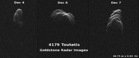
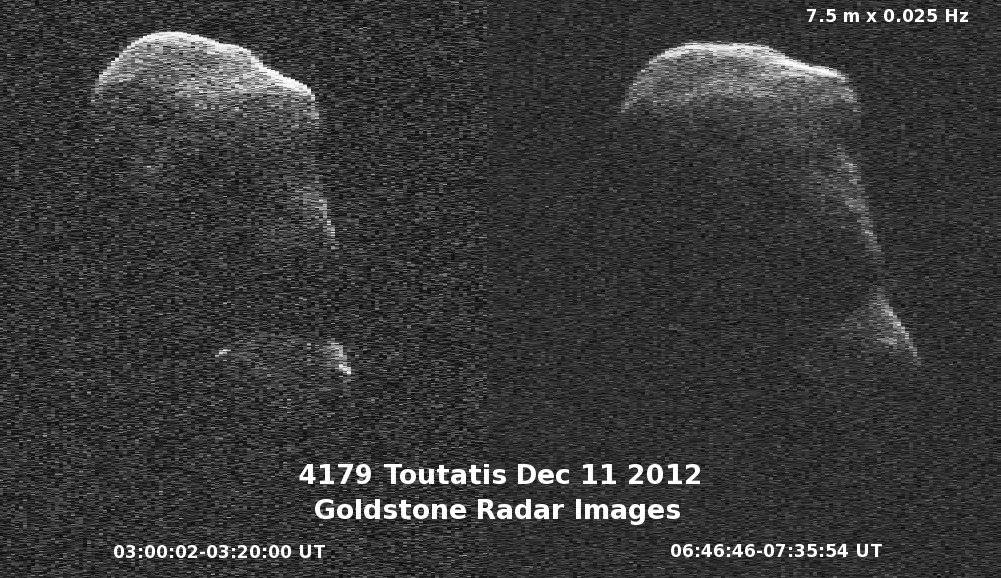
Three views of asteroid 4179 Toutatis made in early Dec. 2012 by Goldstone. In all three, distance from the antenna increases from top to bottom and Doppler frequency increases toward the right, indicating Toutatis rotates from right to left, since that’s the side of the asteroid approaching the observer. Credit: NASA/JPL-Caltech
A slow-rotating asteroid will appear narrower to radar eyes, and if it doesn’t rotate at all, will show up as a “spike” of light. When the antenna happens to be point directly at a pole, the asteroid will appear to be rotating neither toward nor away from the observer and also look like a spike.
Most asteroids fall somewhere in between, and their radar portraits are close to their true shapes. Radar images show us surface textures, shape, size, rotation rate and surface features like craters. 2013 ET joins the ranks of numerous asteroids probed by radio waves from Earth as we try to grasp the complexity of our planetary neighborhood while hoping for we don’t stare down cosmic disaster anytime soon.
NASA has compiled the radar images taken of Asteroid Toutatis during its flyby of Earth this week to create a short movie, which shows the asteroid slowly tumbling. The 64-frame movie was generated from data gathered on December 12 and 13, 2012 by NASA’s 70-meter Goldstone Deep Space Network antenna in Goldstone, California.
NASA provides more information about the video and (4179) Toutatis:
On Dec. 12, the day of its closest approach to Earth, Toutatis was about 18 lunar distances, 4.3 million miles (6.9 million kilometers) from Earth. On Dec. 13, the asteroid was about 4.4 million miles (7 million kilometers), or about 18.2 lunar distances.
The radar data images of asteroid Toutatis indicate that it is an elongated, irregularly shaped object with ridges and perhaps craters. Along with shape detail, scientists are also seeing some interesting bright glints that could be surface boulders. Toutatis has a very slow, tumbling rotational state. The asteroid rotates about its long axis every 5.4 days and precesses (changes the orientation of its rotational axis) like a wobbling, badly thrown football, every 7.4 days.
The orbit of Toutatis is well understood. The next time Toutatis will approach at least this close to Earth is in November of 2069, when the asteroid will safely fly by at about 7.7 lunar distances, or 1.8 million miles (3 million kilometers). An analysis indicates there is zero possibility of an Earth impact over the entire interval over which its motion can be accurately computed, which is about the next four centuries.
This radar data imagery will help scientists improve their understanding of the asteroid’s spin state, which will also help them understand its interior.
The resolution in the image frames is 12 feet (3.75 meters) per pixel.
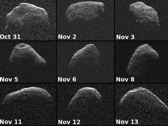
Radar images of asteroid 2007 PA8 acquired on October 28, 29 and 30. (NASA/JPL-Caltech/Gemini)
Take a good look at asteroid 2007 PA8 — over the past week it was making its closest pass of Earth for the next 200 years… and NASA’s 230-foot (70-meter) -wide Deep Space Network antenna at Goldstone, California snapped its picture as it went by.
All right, maybe no “pictures” were “snapped”… 2007 PA8 is a small, dark body that only came within four million miles (6.5 million kilometers) today, Nov. 5 (0.043 AU, or 17 times the distance from Earth to the Moon). But the radar capabilities of the Deep Space Network antenna in California’s Mojave Desert can bounce radar off even the darkest asteroids, obtaining data that can be used to create a detailed portrait.
In the image above, a composite of radar data acquired on October 28, 29 and 30, we can see the irregular shape of 2007 PA8 as it rotates slowly — only once every 3-4 days. The perspective is looking “down” at the 1-mile (1.6-km) -wide asteroid’s north pole, showing ridges and perhaps even some craters.
Although classified as a Potentially Hazardous Asteroid (PHA) by the IAU’s Minor Planet Center the trajectory of 2007 PA8 is well understood. It is not expected to pose any impact threat to Earth in the near or foreseeable future.
2007 PA8 was discovered by LINEAR on August 9, 2007.
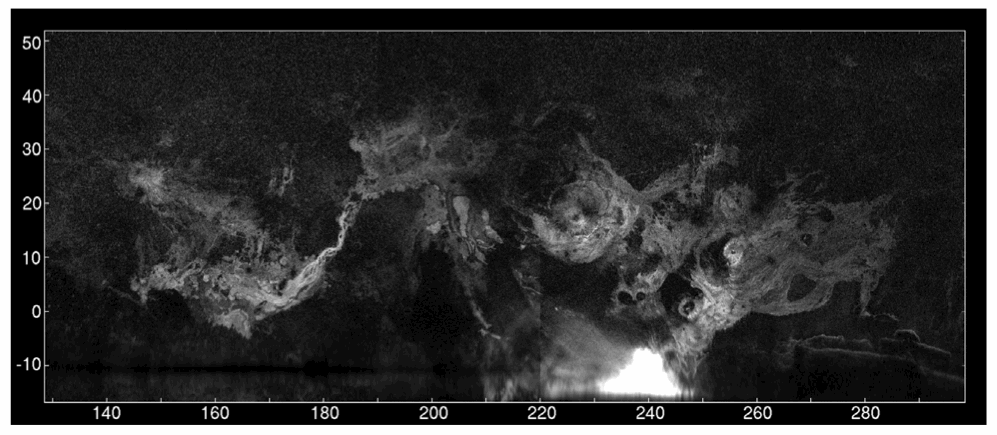
A radar map of Mars’ major volcanic regions created by the Arecibo Observatory in Puerto Rico (John Harmon et al., NAIC)
Even though we currently have several missions exploring Mars both from orbit and on the ground, there’s no reason that robots should be having all the fun; recently a team of radio astronomers aimed the enormous 305-meter dish at Puerto Rico’s Arecibo Observatory at Mars, creating radar maps of the Red Planet’s volcanic regions and capturing a surprising level of detail for Earth-based observations.
The team, led by John Harmon of the National Astronomy and Ionosphere Center, bounced radar waves off Mars from Arecibo’s incredibly-sensitive dish, targeting the volcanic Tharsis, Elysium, and Amazonis regions. Depolarized radar imagery best reveals surface textures; the rougher and less uniform a surface is, the brighter it appears to radar while smooth, flat surfaces appear dark.
What the radar maps portray are very bright — and therefore rough — areas on most of the major volcanoes, although some regions do appear dark, such as the summit of Pavonis Mons.
This likely indicates a covering by smoother, softer material, such as dust or soil. This is actually in line with previous observations of the summit of Pavonis Mons made with the HiRISE camera aboard NASA’s Mars Reconnaissance Orbiter, which showed the summit to appear curiously soft-edged and “out-of-focus”, creating a blurry optical illusion of sorts.
It’s thought that the effect is the result of the build-up of dust over millennia, carried across the planet by dust storms but remaining in place once settled because the Martian wind is just so extremely thin — especially at higher altitudes.
The team also found bright areas located away from the volcanoes, indicating rough flows elsewhere, while some smaller volcanoes appeared entirely dark — again, indicating a possible coating of smooth material like dust or solidified lava flows.
The resolution of the radar maps corresponds to the wavelength of the signals emitted from Arecibo; the 12.6 centimeter signal allows for surface resolution of Mars of about 3 km.
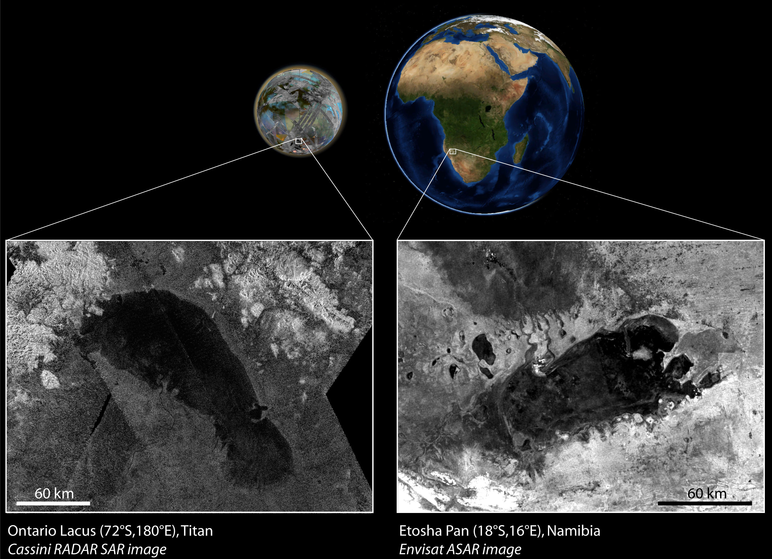
Titan's Ontario Lacus is found to bear a striking resemblance to Namibia's Etosha Pan. (NASA/JPL/ESA)
[/caption]
A large lake on Saturn’s cloud-covered Titan seems very similar to the Etosha Pan, a salt-encrusted dry lakebed in northern Namibia that periodically fills with water. As it turns out, Titan’s “great lake” may also be temporary.
Ontario Lacus, so named because of its similarity both in shape and size to Lake Ontario here on Earth, was first discovered near the south pole of Titan by the Cassini spacecraft in 2009. Its smooth, dark appearance in radar images indicated a uniform and reflective surface, implying a large — although likely shallow — body of liquid.
Of course, on Titan the liquid isn’t water — it’s methane, which is the main ingredient of the hydrologic cycle found on the giant moon. That far from the Sun the temperatures at Titan’s poles fall to a frigid -300ºF (-185ºC), much too cold for water to exist as a liquid and so, on this world, methane has taken its place.
A research team led by Thomas Cornet of the Université de Nantes, France has taken a closer look at Cassini’s radar data of Ontario Lacus and found evidence of channels carved into the southern portion. According to the team, this likely indicates that the lakebed surface is exposed.
Cassini image of Ontario Lacus. (NASA/JPL/SSI)
“We conclude that the solid floor of Ontario Lacus is most probably exposed in those areas,” said Cornet.
In addition, sediment layers surrounding the lake suggest that the liquid level has varied.
All in all, this reveals a striking resemblance between Ontario Lacus and Namibia’s Etosha Pan — an “ephemeral lake” that is dry for much of the year, occasionally filling with a shallow layer of water which evaporates, leaving salty rings of sediment.
The inherent otherworldly nature of Etosha Pan is further underlined — and perhaps foreshadowed! — by its use as a backdrop in the 1968 sci-fi film 2001: A Space Odyssey.
Although Ontario Lacus was initially thought to be permanently filled with liquid hydrocarbons, the team’s findings draw a strong correlation with this well-known Earthly environment, suggesting a much more temporary nature and showing the value of comparative research.
Satellite image of Etosha Pan, acquired on April 28, 2012. (Chelys/EOSnap)
“These results emphasise the importance of comparative planetology in modern planetary sciences,” said Nicolas Altobelli, Cassini project scientist for ESA.”Finding familiar geological features on alien worlds like Titan allows us to test the theories explaining their formation.”
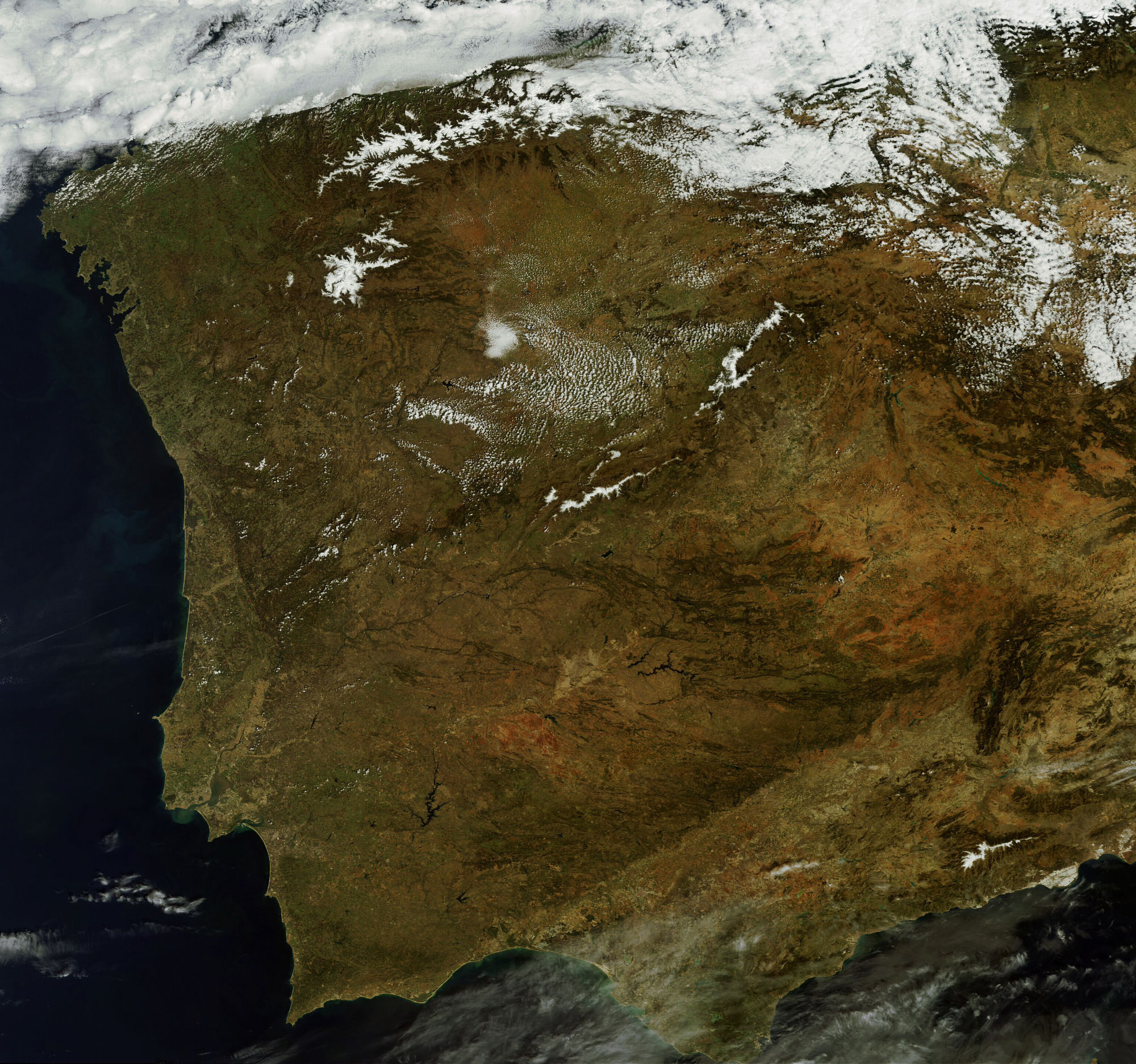
This MERIS image of Spain and Portugal could be Envisat's last. (Chelys/EOsnap)
[/caption]
The European Space Agency’s venerable Envisat satellite may have sent back its final image, according to recent news from the Agency.
On April 8, ESA lost communication with the Earth-observation satellite, preventing reception of data as it passed over the Kiruna station in Sweden. Although it’s been confirmed that the satellite is still in orbit, the recovery team has not been able to re-establish contact.
The image above, showing part of the Iberian peninsula, was from the last data to be received from Envisat before it fell silent.
Radar image of Envisat. (Fraunhofer Institute for High Frequency Physics and Radar Techniques.)
Launched in March 2002, Envisat has been helping researchers examine our planet for over ten years — five years longer than its original mission duration. It has completed more than 50,000 orbits and returned thousands of images, as well as a wealth of data about the land, oceans and atmosphere.
Envisat data was instrumental in over 4,000 projects from 70 countries.
Germany’s Tracking and Imaging Radar captured an image of the satellite, revealing that it is still intact and in a stable orbit. Still, all attempts at recovery have so far been unsuccessful.
A contingency agreement with the Canadian Space Agency on Radarsat will be activated to fulfill user requirements if Envisat cannot be brought back online.