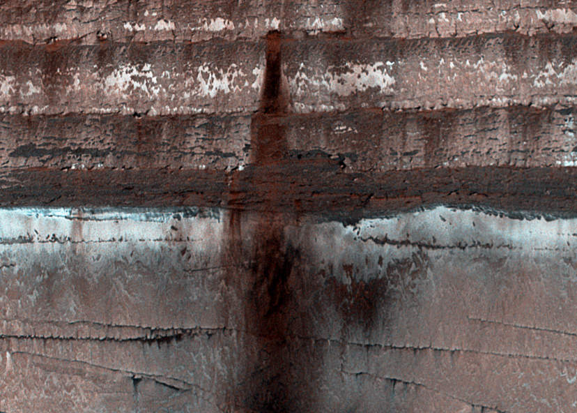
Loose soil, dust and rock stains an icy cliffside on Mars (NASA/JPL/University of Arizona)
Mars may be geologically inactive but that doesn’t mean there’s nothing happening there — seasonal changes on the Red Planet can have some very dramatic effects on the landscape, as this recent image from the HiRISE camera shows!
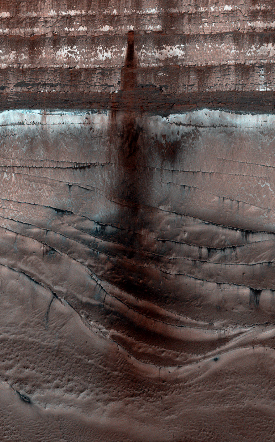
The full extent of the 1000-meter-long dusty landslide (NASA/JPL/University of Arizona)
When increasing light from the springtime Sun warms up the sides of sheer cliffs made from countless layers of water and carbon dioxide ice near Mars’ north pole, some of that CO2 ice sublimes, sending cascades of loose soil and dust down to the terraced base below. This uncovered material stains the frost-covered polar surface dark, outlining the paths of avalanches for HiRISE to easily spot from orbit. (See the original HiRISE image here.)
The rust-colored avalanche shown above has fallen hundreds of meters from the middle of a layered ice deposit, spreading nearly a kilometer across the frozen ridges at the base of the cliff. The view was acquired on Sept. 13, 2013.
Check out a video explaining this view and the processes that created it below, narrated by Phil Plait (aka the Bad Astronomer).
Mars’ seasonal polar caps are composed primarily of carbon dioxide frost. This frost sublimates (changes from solid directly to gas) in the spring, boosting the pressure of Mars’ thin atmosphere. In the fall the carbon dioxide condenses, causing the polar caps to reach as far as ~55 degrees latitude by late winter. By learning about current processes on a local level we can learn more about how to interpret the geological record of climate changes on Mars. (Source)
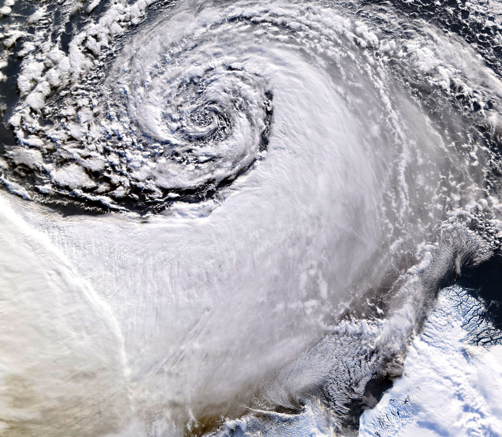
Satellite image of a cloud vortex off the coast of Greenland (NASA/MODIS/Chelys)
Looking south across the southern tip of Greenland, this satellite image shows an enormous cloud vortex spiraling over the northern Atlantic ocean on January 26, 2013. An example of the powerful convection currents in the upper latitudes, these polar low cyclones are created when the motion of cold air is energized by the warmer ocean water beneath.
Sometimes referred to as Arctic cyclones, these spiraling storms can bring gale-force winds and heavy snowfall over a wide area of ocean during their 12- to 36-hour lifespans. Hurricane-type storms don’t only form in the tropics!
This image was captured by the MODIS instrument on NASA’s Aqua satellite from its polar orbit 705 km (438 miles) above the Earth. The view has been rotated so south is up; the southernmost tip of Greenland can be seen at lower right. Click for an impressive high-resolution view.
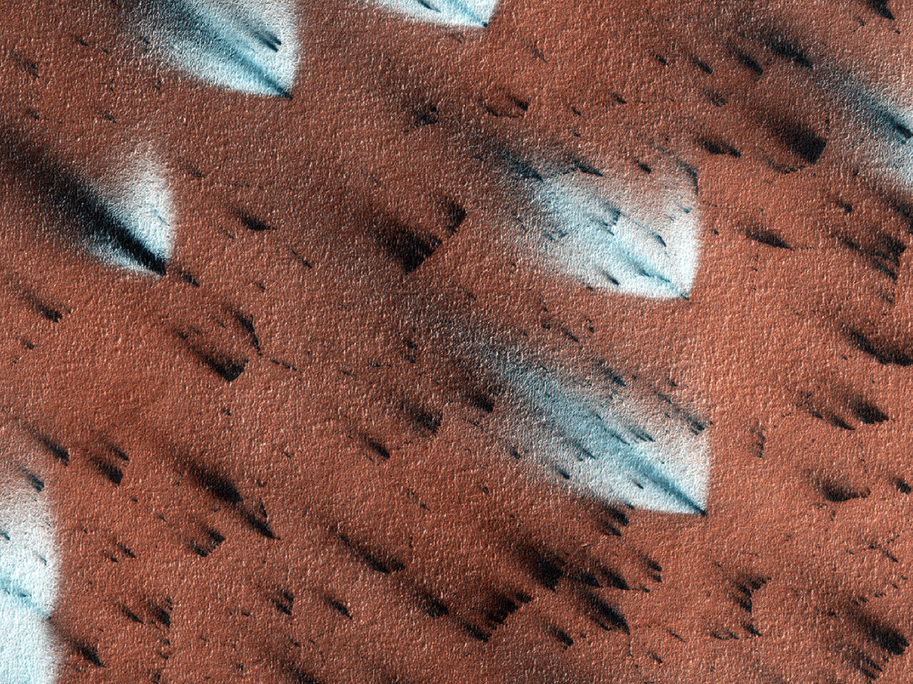
Mars may not be tectonically active but that doesn’t mean there’s nothing happening on the Red Planet’s surface. This video from NASA’s Jet Propulsion Laboratory shows the dramatic seasonal changes that take place in Mars’ polar regions when the frozen carbon dioxide — called “dry ice” — coating the basalt sand dunes begins to thaw and cracks, releasing jets of sublimating CO2 gas that carry dark material upwards and outwards, staining the frozen surface of the dunes. Imagine what it would be like to be standing nearby when these jets erupt!
This process occurs around the upper latitudes of Mars every spring and is responsible for the dark (and sometimes light) mottled discolorations observed across sandy and dune-covered terrain.
Bright fans are created when surface conditions cause escaping CO2 gas to condense back onto the surface. (NASA/JPL/University of Arizona)
If a prevailing wind happens to be blowing when the gases are escaping the cracks in the ice, whatever material they are carrying will be spread by the wind across the dunes in long streaks and fans. Read more about this process here.
“It’s an amazingly dynamic process. We had this old paradigm that all the action on Mars was billions of years ago. Thanks to the ability to monitor changes with the Mars Reconnaissance Orbiter, one of the new paradigms is that Mars has many active processes today.”
– Candice Hansen, Planetary Science Institute
The images in the video were acquired by the HiRISE camera aboard the Mars Reconnaissance Orbiter, which has been orbiting and observing Mars in unprecedented detail for over six years. See more HiRISE images of the Martian surface here.
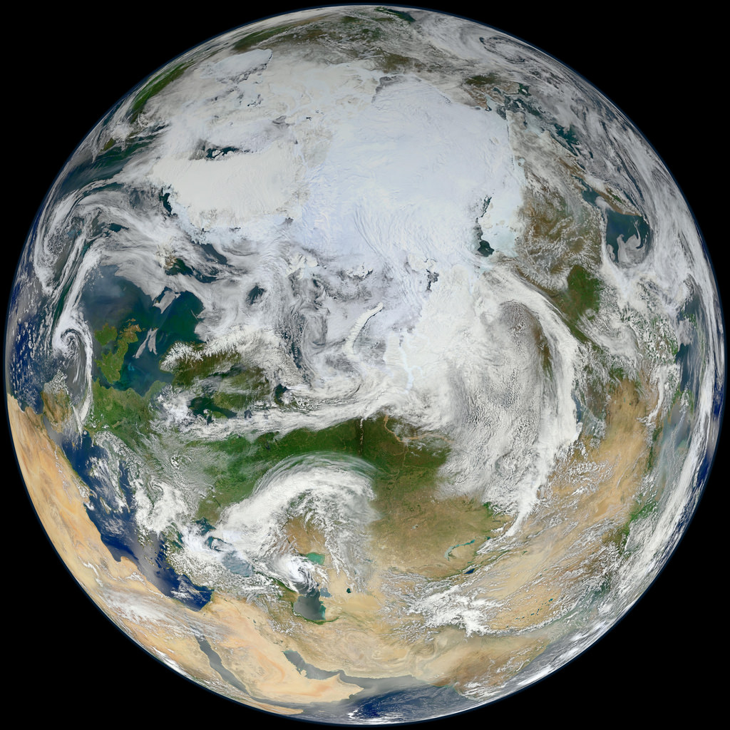
This latest portrait of Earth from NASA’s Suomi NPP satellite puts the icy Arctic in the center, showing the ice and clouds that cover our planet’s northern pole. The image you see here was created from data acquired during fifteen orbits of Earth.
In January of this year Suomi NPP images of Earth were used to create an amazing “Blue Marble” image that spread like wildfire across the internet, becoming one of the latest “definitive” images of our planet. Subsequent images have been released by the team at Goddard Space Flight Center, each revealing a different perspective of Earth.
NASA launched the National Polar-orbiting Operational Environmental Satellite System Preparatory Project (or NPP) on October 28, 2011 from Vandenberg Air Force Base. On Jan. 24, NPP was renamed Suomi National Polar-orbiting Partnership, or Suomi NPP, in honor of the late Verner E. Suomi. It’s the first satellite designed to collect data to improve short-term weather forecasts and increase understanding of long-term climate change.
Suomi NPP orbits the Earth about 14 times each day and observes nearly the entire surface of the planet.
Ice-coated mountaintops of Alexander Island, one of the largest islands off Antarctica. Credit: Michael Studinger/NASA.
[/caption]
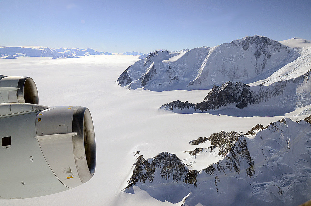
Views from the window of NASA’s DC-8 reveal sweeping expanses of ice and rock as part of the ongoing 2011 Operation IceBridge survey of Antarctica’s ice cover.
Now in its third season, Operation IceBridge is a six-year-long mission to study the dynamics of the Antarctic and Arctic ice sheets. It’s the largest ever aerial survey of the polar ice and will yield valuable data on the state of Earth’s vast reservoirs of frozen water, including the land and sea underneath and how they are being affected by today’s rapidly changing climate.
The ridges of the Shackleton Range cast shadows onto Antarctica's ice. Credit: Michael Studinger/NASA.
Researchers – like Michael Studinger, who took the incredible photos seen here – fly over Greenland during the months of March through May and over Antarctica in October and November. NASA’s instrument-laden DC-8 flies over these remote locations at a low altitude of about 1,500 feet, often with little or no advance weather data.
98 percent of Antarctica is covered with ice. Information obtained by Operation IceBridge will be combined with satellite data to create the most accurate models possible of Antarctic ice loss and how it will affect future sea level rise.
Mountains piled with snow and ice rise above the clouds on Alexander Island. Credit: Michael Studinger/NASA.
This season’s Antarctic IceBridge campaign features NASA’s DC-8, at 157 feet long the largest plane in the agency’s airborne research fleet, and will also feature the debut of the Gulfstream V (G-V) operated by the National Science Foundation and National Center for Atmospheric Research.
While the DC-8 flies at low altitudes, the G-V will fly above 30,000 feet to utilize its Land, Vegetation and Ice Sensor (LVIS), which makes detailed topographic studies of the surface.
“With IceBridge, our aim is to understand what the world’s major ice sheets could contribute to sea-level rise. To understand that you have to record how ice sheets and glaciers are changing over time.”
– Michael Studinger, IceBridge project scientist at NASA’s Goddard Space Flight Center in Greenbelt, Md.
The wing of NASA's DC-8 cuts across the frozen expanse of the Brunt Ice Shelf, with its 100-foot-high cliff face. Credit: Michael Studinger/NASA.
Our beautiful, precious, life-supporting Earth as seen on July 6, 2015 from a distance of one million miles by a NASA scientific camera aboard the Deep Space Climate Observatory spacecraft. Credits: NASA
For those people who have had the privilege of jet-setting or traveling the globe, its pretty obvious that the world is a pretty big place. When you consider how long it took for human beings to settle every corner of it (~85,000 years, give or take a decade) and how long it took us to explored and map it all out, terms like “small world” cease to have any meaning.
But to complicate matters a little, the diameter of Earth – i.e. how big it is from one end to the other – varies depending on where you are measuring from. Since the Earth is not a perfect sphere, it has a different diameter when measured around the equator than it does when measured from the poles. So what is the Earth’s diameter, measured one way and then the other?
Oblate Spheroid:
Thanks to improvements made in the field of astronomy by the 17th and 18th centuries – as well as geodesy, a branch of mathematics dealing with the measurement of the Earth – scientists have learned that the Earth is not a perfect sphere. In truth, it is what is known as an “oblate spheroid”, which is a sphere that experiences flattening at the poles.
Data from the Earth2014 global relief model, with distances in distance from the geocentre denoted by color. Credit: Geodesy2000
According to the 2004 Working Group of the International Earth Rotation and Reference Systems Service (IERS), Earth experiences a flattening of 0.0033528 at the poles. This flattening is due to Earth’s rotational velocity – a rapid 1,674.4 km/h (1,040.4 mph) – which causes the planet to bulge at the equator.
Equatorial vs Polar Diameter:
Because of this, the diameter of the Earth at the equator is about 43 kilometers (27 mi) larger than the pole-to-pole diameter. As a result, the latest measurements indicate that the Earth has an equatorial diameter of 12,756 km (7926 mi), and a polar diameter of 12713.6 km (7899.86 mi).
In short, objects located along the equator are about 21 km further away from the center of the Earth (geocenter) than objects located at the poles. Naturally, there are some deviations in the local topography where objects located away from the equator are closer or father away from the center of the Earth than others in the same region.
The most notable exceptions are the Mariana Trench – the deepest place on Earth, at 10,911 m (35,797 ft) below local sea level – and Mt. Everest, which is 8,848 meters (29,029 ft) above local sea level. However, these two geological features represent a very minor variation when compared to Earth’s overall shape – 0.17% and 0.14% respectively.
Meanwhile, the highest point on Earth is Mt. Chiborazo. The peak of this mountain reaches an attitude of 6,263.47 meters (20,549.54 ft) above sea level. But because it is located just 1° and 28 minutes south of the equator (at the highest point of the planet’s bulge), it receives a natural boost of about 21 km.
Mean Diameter:
Because of the discrepancy between Earth’s polar and equatorial diameter, astronomers and scientists often employ averages. This is what is known as its “mean diameter”, which in Earth’s case is the sum of its polar and equatorial diameters, which is then divided in half. From this, we get a mean diameter of 12,742 km (7917.5 mi).
The difference in Earth’s diameter has often been important when it comes to planning space launches, the orbits of satellites, and when circumnavigating the globe. Given that it takes less time to pass over the Arctic or Antarctica than it does to swing around the equator, sometimes this is the preferred path.