This Is the Very First Photo of Earth From Space

The first photo of Earth from space was taken on Oct. 24, 1947 (Credit: White Sands Missile Range/Applied Physics Laboratory)

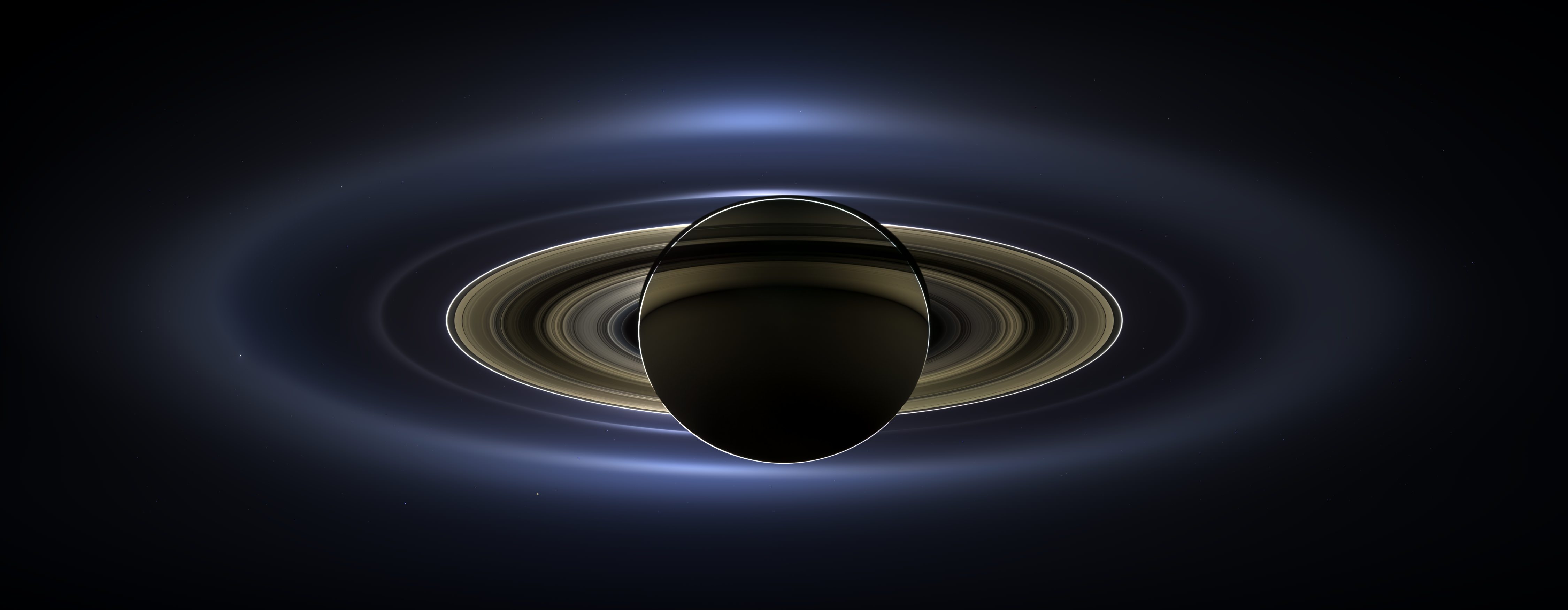
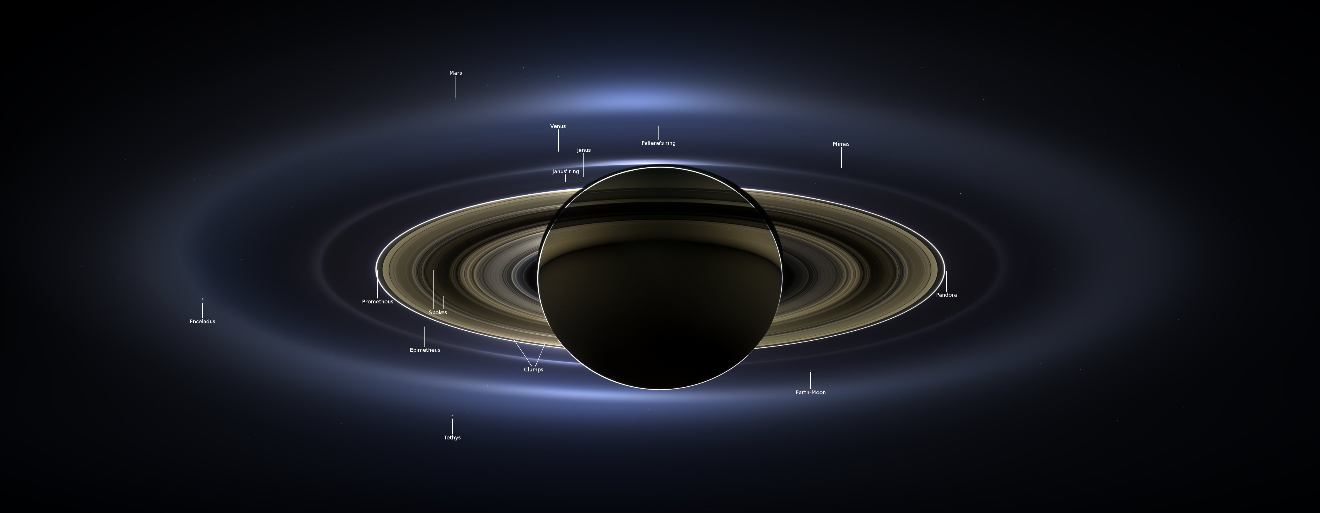
These days we see photos of our planet taken from space literally every day. Astronauts living aboard the International Space Station, weather and Earth-observing satellites in various orbits, even distant spacecraft exploring other planets in our Solar System… all have captured images of Earth from both near and far. But there was a time not that long ago when there were no pictures of Earth from space, when a view of our planet against the blackness of the cosmos was limited to the imagination of dreamers and artists and there was nothing but the Moon orbiting our world.

On this day in 1946, before Apollo, before Mercury, even before Sputnik, that was no longer the case.

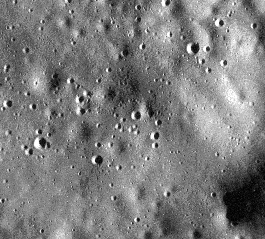
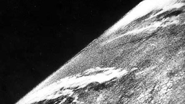
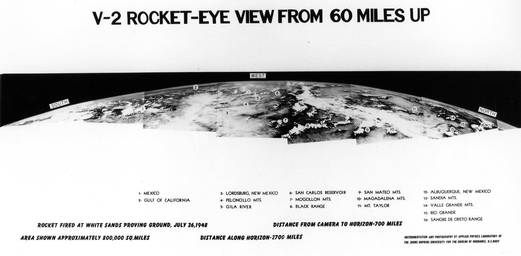
The image above shows the first photo captured of Earth from space, taken by a camera mounted to a V-2 rocket that was launched from the U.S. Army’s White Sands Missile Range in New Mexico. Taken to the United States by the dozen from Germany after the end of World War II, the V-2 (for “Vergeltungswaffe 2”) missiles were used by the Army to improve on their own rocket designs and also by scientists who were permitted to fill their payloads with experiments.

On October 24, 1946, a V-2 was launched from the Missile Range while a mounted 35mm movie camera captured images every 1.5 seconds. It reached an altitude of 65 miles before crashing back to Earth and, while the camera was destroyed on impact, the film cassette survived. The grainy photo seen above was on that roll, one of our first views of Earth from above the atmosphere.

(Okay, technically there’s still atmosphere above 65 miles — even the ISS orbiting at 260-plus statute miles has to give itself a boost to compensate for drag now and again — but the official aeronautical delineation of “space” begins at about 62 miles, or 100 km: the Kármán Line. V-2 #13 passed that mark in 1946 by 3 miles.)

In the following years more V-2 rockets would be launched, some reaching heights of 100 miles, giving us many more detailed views of our planet as it looks from space and prompting Clyde Holliday, the APL engineer who developed the mounted film cameras, to envision that “the entire land area of the globe might be mapped in this way.”

Assembled panorama of V-2 images taken from an altitude of 60 miles in 1948 (JHUAPL/US Navy)

Now, 68 years later, seeing pictures of Earth from space are a much more common, if no less amazing, occurrence. But it all started with that one launch of a missile designed for war but repurposed for science.

Read more here in an article for Smithsonian’s Air & Space by Tony Reichhardt, and watch a contemporary news reel below about the 1946 V-2 launch:

Source: Air & Space

MESSENGER Completes Second Burn to Maintain Mercury Orbit

Illustration of MESSENGER in orbit around Mercury (NASA/JPL/APL)

A little over a week before NASA’s MAVEN spacecraft fired its rockets to successfully enter orbit around Mars, MESSENGER performed a little burn of its own – the second of four orbit correction maneuvers (OCMs) that will allow it to remain in orbit around Mercury until next March. Although it is closing in on the end of its operational life it’s nice to know we still have a few more months of images and discoveries from MESSENGER to look forward to!

MESSENGER's orientation after the start of orbit correction maneuver 10 (OCM-10). Credit: NASA/Johns Hopkins University Applied Physics Laboratory/Carnegie Institution of Washington
MESSENGER’s orientation after the start of orbit correction maneuver 10 (OCM-10). Credit: NASA/Johns Hopkins University Applied Physics Laboratory/Carnegie Institution of Washington

The first OCM burn was performed on June 17, raising MESSENGER’s orbit from 115 kilometers (71.4 miles) to 156.4 kilometers (97.2 miles) above the surface of Mercury. That was the ninth OCM of the MESSENGER mission, and at 11:54 a.m. EDT on Sept. 12, 2014, the tenth was performed.

Read more: Mercury’s Ready for Its Close-up, Mr. MESSENGER

According to the mission news article:

At the time of this most recent maneuver, MESSENGER was in an orbit with a closest approach of 24.3 kilometers (15.1 miles) above the surface of Mercury. With a velocity change of 8.57 meters per second (19.17 miles per hour), the spacecraft’s four largest monopropellant thrusters (with a small contribution from four of the 12 smallest monopropellant thrusters) nudged the spacecraft to an orbit with a closest approach altitude of 94 kilometers (58.4 miles). This maneuver also increased the spacecraft’s speed relative to Mercury at the maximum distance from Mercury, adding about 3.2 minutes to the spacecraft’s eight-hour, two-minute orbit period.

OCM-10 lasted for 2 1/4 minutes and added 3.2 minutes to the spacecraft’s 8-hour, 2-minute-long orbit. (Source)

The next two burns will occur on October 24 and January 21.

After its two final successful burns MESSENGER will be out of propellant, making any further OCMs impossible. At the planned end of its mission MESSENGER will impact Mercury’s surface in March of 2015.

WATCH: A Tribute to MESSENGER

Built and operated by The Johns Hopkins University Applied Physics Laboratory (JHUAPL), MESSENGER launched from Cape Canaveral Air Force Station on August 3, 2004. It entered orbit around Mercury on March 18, 2011, the first spacecraft ever to do so. Since then it has performed countless observations of our Solar System’s innermost planet and has successfully mapped 100% of its surface. Check out the infographic below showing some of the amazing numbers racked up by MESSENGER since its launch ten years ago, and read more about the MESSENGER mission here.

"MESSENGER by the Numbers" - and infographic by NASA
“MESSENGER by the Numbers” – an infographic by NASA


Mercury’s Hot Flow Revealed by MESSENGER

A hot flow anomaly, or HFA, has been identified around Mercury (Credit: NASA/Duberstein)

Our Sun is constantly sending a hot stream of charged atomic particles out into space in all directions. Pouring out from holes in the Sun’s corona, this solar wind flows through the Solar System at speeds of over 400 km/s (that’s 893,000 mph). When it encounters magnetic fields, like those generated by planets, the flow of particles is deflected into a bow shock — but not necessarily in a uniform fashion. Turbulence can occur just like in air flows on Earth, and “space weather” results.

One of the more curious effects is a regional reversal of the flow of solar wind particles. Called a “hot flow anomaly,” or HFA, these energetic phenomena occur almost daily in Earth’s magnetic field, as well as on Jupiter and Saturn, and even on Mars and Venus where the magnetic fields are weak (but there are still planets blocking the stream of charged particles.)

Not to be left out in the cold, Mercury is now known to display HFAs, which have been detected for the first time by the MESSENGER spacecraft.

A NASA news release describes how the HFAs were confirmed:

The first measurement was of magnetic fields that can be used to detect giant electric current sheets that lead to HFAs. The second was of the heating of the charged particles. The scientists then analyzed this information to quantify what kind of turbulence exists in the region, which provided the final smoking gun of an HFA.

“Planets have a bow shock the same way a supersonic jet does,” explains Vadim Uritsky at NASA’s Goddard Space Flight Center. “These hot flow anomalies are made of very hot solar wind deflected off the bow shock.”

The different colors in this MESSENGER image of Mercury indicate the chemical, mineralogical, and physical differences between the rocks that make up the planet’s surface.  Credit: NASA/Johns Hopkins University Applied Physics Laboratory/Carnegie Institution of Washington.
Enhanced-color image of Mercury indicating the chemical and physical differences across its surface.  Credit: NASA/Johns Hopkins University Applied Physics Laboratory/Carnegie Institution of Washington.

The solar wind is not 100% uniform; it has discontinuities within its own complex magnetic fields. When these shifting fields pile up against a planet’s bow shock they can create turbulence patterns that trap hot plasma, which in turn produces its own magnetic fields. The shockwaves, heat, and energy produced are powerful enough to actually reverse the flow of the solar wind within the HFA bulge.

And the word “hot” is putting it lightly — plasma temperatures in an HFA can reach 10 million degrees.

Read more: “Extreme” Solar Wind Blasts Mercury’s Poles

Mercury may be only a little larger than our Moon but it does possess an internally-generated dipolar magnetic field, unlike the Moon, Venus, and Mars which have only localized or shallow fields. The confirmed presence of HFAs on Mercury indicates that they may be a feature in all planetary bow shocks, regardless of how their magnetic fields — if any — are produced.

The team’s results were published in the February 2014 issue of the Journal of Geophysical Research: Space Physics.

___________________

In related news, on June 17 MESSENGER successfully completed the first orbit adjustment maneuver to prepare it for its new — and final — low-altitude campaign, during which it will obtain its highest-resolution images ever of the planet’s surface and perform detailed investigations of its composition and magnetic field. Read more on the MESSENGER site here.

Source: NASA

Mercury’s Ready For Its Close-Up, Mr. MESSENGER

One of the highest-resolution images of Mercury's surface ever acquired.

Are you ready for a good close look at Mercury? At an incredible 5 meters per pixel, this is one of the highest-resolution images of Mercury’s surface ever captured. It was acquired on March 15 with the MESSENGER spacecraft’s MDIS (Mercury Dual Imaging System) instrument and shows an 8.3-km (5.2-mile) -wide section of Mercury’s north polar region, speckled with small craters and softly rolling hills.

Because MESSENGER was moving so quickly relative to the targeted area it was imaging, a short exposure time was necessary to avoid blurring. As a result the image appears a bit grainy. See the original map projection here.

Wondering what the next-best image was of Mercury? Find out below:

The previous record for most extreme close-up of Mercury was held by this image:

7 meter/pixel targeted observation of Mercury by the MESSENGER spacecraft

It was acquired as a targeted observation by MESSENGER’s Narrow-Angle Camera on April 30, 2012, and has a resolution of 7 meters/pixel. It shows an impact melt-covered area about 11 km (7 miles) across near Gaugin crater.

(Although Mercury’s surface may at first appear strikingly similar to the Moon’s, it’s been known since the Mariner 10 mission that the two worlds are very different at fundamental geologic and compositional levels. Read more on that here.)

Images like these are extremely special; during the first two years of MESSENGER’s mission in orbit around Mercury, over 150,000 images were acquired but only five images had resolutions better than 10 meters per pixel.

Artist's impression of MESSENGER orbiting Mercury
Artist’s impression of MESSENGER orbiting Mercury

On April 20, 2014, MESSENGER completed its 3,000th orbit of Mercury (3,075 to date) and is steadily moving into an even lower-altitude orbit. MESSENGER now comes within less than 200 km (124 miles) of the planet’s surface when it passes over its north pole every eight hours… that’s less than half the altitude of the Space Station!

Orbiting at such a low altitude and so often will allow MESSENGER to examine Mercury’s surface in unprecedented detail. Now that 100% of the planet has been successfully mapped by MESSENGER it can spend its second — and last — extended mission investigating specific scientific targets.

Watch: A Tribute to MESSENGER 

“The final year of MESSENGER’s orbital operations will be an entirely new mission,” said Sean Solomon, Principal Investigator for MESSENGER. “With each orbit, our images, our surface compositional measurements, and our observations of the planet’s magnetic and gravity fields will be higher in resolution than ever before. We will be able to characterize Mercury’s near-surface particle environment for the first time. Mercury has stubbornly held on to many of its secrets, but many will at last be revealed.”

Read more in a recent news release from the MESSENGER team here.

Want to explore a high-res map of Mercury and see where MESSENGER is right now? Click here.

Image credits: NASA/Johns Hopkins University Applied Physics Laboratory/Carnegie Institution of Washington

Cassini’s View of Another Pale Blue Dot

Uranus as seen by Cassini on July 19, 2013 (NASA/JPL-Caltech/SSI)

When you hear the words “pale blue dot” you’re probably reminded of the famous quote by Carl Sagan inspired by an image of Earth as a soberingly tiny speck, as imaged by Voyager 1 on Feb. 14, 1990 from beyond the orbit of Pluto. But there’s another pale blue world in our Solar System: the ice giant Uranus, and its picture was captured much more recently by the Cassini spacecraft from orbit around Saturn on April 11, 2014.

Released today by the Cassini Imaging Team, the image above shows Uranus as a tiny blue orb shining far beyond the bright hazy bands of Saturn’s F ring.

“Do you relish the notion of being a Saturnian, and gazing out from the lofty heights of Saturn at the same planets we see here from the Earth?”
– Carolyn Porco, Cassini Imaging Team Leader

Uranus’ coloration is a result of methane high in its frigid atmosphere. According to the description on the CICLOPS site, “methane on Uranus — and its sapphire-colored sibling, Neptune — absorbs red wavelengths of incoming sunlight, but allows blue wavelengths to escape back into space, resulting in the predominantly bluish color seen here.”

This was also the first time Uranus had been imaged by the Cassini spacecraft, which has been in orbit around Saturn since 2004. In fact its ten-year orbital anniversary will come on July 1.

This image adds one more planet to the list of worlds captured on Camera by Cassini, which made headlines last fall when a glorious mosaic was released that featured a backlit Saturn in eclipse surrounded by its luminous rings, the specks of several of its moons, and the distant dots of Venus, Mars, and the Earth and Moon. Made from 141 separate exposures, the mosaic was captured on July 19, 2013 — known by many space aficionados as “the day the Earth smiled” as it was the first time the world’s population was alerted beforehand that its picture would be taken from over 900 million miles away.

Saturn — with its terrestrial spacecraft in tow — was about 28.6 AU away from Uranus when the image was acquired. That’s about  4.28 billion kilometers (2.66 billion miles). From that distance the glow of the 51,118-kilometer (31,763-mile) -wide Uranus is reduced to a mere few pixels (which required digital brightening by about 4.5x, as well.)

Read more on the Cassini Imaging Central Laboratory for Operations (CICLOPS) page here and in a news release from NASA’s JPL here.

Image credit: NASA/JPL-Caltech/SSI. Source: Carolyn Porco, CICLOPS Director

An Afternoon on Mars

A post-processed mosaic of MSL Mastcam images from Sol 582 (NASA/JPL-Caltech/MSSS. Edit by Jason Major)
Afternoon on Mars (MSL Mastcam mosaic)(NASA/JPL-Caltech/MSSS. Edit by Jason Major)

Here’s a pretty picture for your Friday: a mosaic of Mastcam images acquired by Curiosity on mission Sol 582, also known to us Earthlings as Thursday, March 27, 2014. Barsoom sure looks lovely this time of year!

The mosaic was assembled from five raw images downlinked to the MSL site earlier today. I pasted them together in Photoshop, aligning the edge of one to the next using landscape objects as visual markers, and then did a little bad pixel cleanup (Mastcam has a notorious black smudge a few pixels wide just off-center) and then cropped the result, with a bit of surface cloning at the lower right to fill in some missing Martian soil. The I hit it with an HDR filter, which I’m usually not a fan of but in in this instance it turned out pretty nice.

See s hi-resolution version of this on my Flickr album.

You can find all the raw images from Curiosity — including the ones I used to compose this image — here.

Image credit: NASA/JPL-Caltech/MSSS. Edit/composite by Jason Major.

Mercury Shrinking: the First Rock from the Sun Contracted More than Once Thought

MESSENGER image of Mercury from its third flyby (NASA/Johns Hopkins University Applied Physics Laboratory/Carnegie Institution of Washington)

Whatever Mercury’s did to trim down its waistline has worked better than anyone thought — the innermost planet in our Solar System has reduced its radius* by about 7 kilometers (4.4 miles), over double the amount once estimated by scientists.

Of course you wouldn’t want to rush to begin the Mercury diet — its planetary contraction has taken place over the course of 3.8 billion years, since the end of the Late Heavy Bombardment. Still — lookin’ good, Mercury!

These findings come thanks to the MESSENGER spacecraft, in orbit around Mercury since 2011. Now that MESSENGER has successfully mapped literally all of Mercury’s surface, detailed measurements of more than 5,900 landforms created by cooling and contraction of the planet’s crust have allowed researchers to more precisely determine its geologic history and answer some decades-old questions raised by Mariner 10 images.

“This discrepancy between theory and observation, a major puzzle for four decades, has finally been resolved,” said MESSENGER Principal Investigator Sean Solomon. “It is wonderfully affirming to see that our theoretical understanding is at last matched by geological evidence.”

This image shows a long collection of ridges and scarps on the planet Mercury called a fold-and-thrust belt. The belt stretches over 336 miles (540 km). The colors correspond to elevation—yellow-green is high and blue is low. Image courtesy NASA/Johns Hopkins University Applied Physics Laboratory/Carnegie Institution of Washington.
This image shows a fold-and-thrust belt stretching over 540 km on Mercury. The colors correspond to elevation— yellow/green is high and blue is low. (Courtesy NASA/Johns Hopkins University Applied Physics Laboratory/Carnegie Institution of Washington.)

Using high-definition images acquired with MESSENGER’s MDIS (Mercury Dual Imaging System) instrument, planetary geologist at the Carnegie Institution of Washington and study lead author Paul Byrne and his colleagues identified 5,934 lobate scarps and wrinkle ridges on Mercury that are the result of contraction. From measurements of these features, the team determined that the planet’s radial contraction was much more than that estimated by models based on incomplete imaging from NASA’s Mariner 10 mission — the very first spacecraft to visit (but not orbit) Mercury.

Watch: Fly Across Mercury with MESSENGER!

“These new results resolved a decades-old paradox between thermal history models and estimates of Mercury’s contraction,” said Byrne. “Now the history of heat production and loss and global contraction are consistent.

“Interestingly, our findings are also reminiscent of now-obsolete models for how large-scale geological deformation occurred on Earth when the scientific community thought that the Earth only had one tectonic plate,” Byrne said. “Those models were developed to explain mountain building and tectonic activity in the nineteenth century, before plate tectonics theory.”

Unlike Earth, Mercury has only one global tectonic plate.

The findings were published in the Sunday, March 16 edition of the journal Nature Geoscience.

Source: MESSENGER press release. Read more about tectonic features on Mercury here.

*Mercury’s current radius is  2,440 kilometers (1,516 miles).

This Time-Lapse ISS Video Isn’t Just Another Time-Lapse ISS Video

It’s actually remarkably beautiful, and well worth two minutes of your time.*

Assembled from actual photographs taken by astronauts aboard the Space Station, many of them by Don Pettit during Expedition 31 (Don took a lot of photos) this timelapse “The World Outside My Window” by David Peterson ramps up the artistic value by featuring super-duper high definition, smoothed frame transitions and a musical score by “Two Steps From Hell.” (Don’t worry, that sounds scarier than it is.) Even if you’ve seen some of these clips before, they’re worth another go.

After all, there’s no good reason not to be reminded of how beautiful our planet is from space. Enjoy!

*It’s actually two minutes and twenty-eight seconds but I don’t think you’ll mind.

The Day the Earth Smiled: Saturn Shines in this Amazing Image from the Cassini Team

The "pale blue dot" of Earth as seen from Cassini on July 19, 2013.

This summer, for the first time ever, the world was informed that its picture was going to be taken from nearly a billion miles away as the Cassini spacecraft captured images of Saturn in eclipse on July 19. On that day we were asked to take a moment and smile and wave at Saturn, from wherever we were, because the faint light from our planet would be captured by Cassini’s camera, shielded by Saturn from the harsh glare of the Sun.

A few preliminary images were released just a few days later showing the “pale blue dot” of Earth nestled within the glowing bands of Saturn’s rings. It was an amazing perspective of our planet, and we were promised that the full mosaic of Cassini images was being worked on and would be revealed in the fall.

Well, it’s fall, and here it is:

The full mosaic from the Cassini imaging team of Saturn on July 19, 2013... the "Day the Earth Smiled"
The full mosaic from the Cassini imaging team of Saturn on July 19, 2013… the “Day the Earth Smiled”

Simply beautiful!

Cassini Imaging Team leader Carolyn Porco wrote on her Facebook page:

“After much work, the mosaic that marks that moment the inhabitants of Earth looked up and smiled at the sheer joy of being alive is finally here. In its combination of beauty and meaning, it is perhaps the most unusual image ever taken in the history of the space program.”

Download a full-size version here.

Earth and Moon seen by Cassini on July 19, 2013

In this panorama of the Saturnian system, a view spanning 404,880 miles (651,591 km), we see the planet silhouetted against the light from the Sun. It’s a unique perspective that highlights the icy, reflective particles that make up its majestic rings and also allows our own planet to be seen, over 900 million miles distant. And it’s not just Earth that was captured, but the Moon, Venus, and Mars were caught in the shot too.

Read more: Could Cassini See You on the Day the Earth Smiled?

According to the description on the CICLOPS page, “Earth’s twin, Venus, appears as a bright white dot in the upper left quadrant of the mosaic… between the G and E rings. Mars also appears as a faint red dot embedded in the outer edge of the E ring, above and to the left of Venus.”

This was no simple point-and-click. Over 320 images were captured by Cassini on July 19 over a period of four hours, and this mosaic was assembled from 141 of those images. Because the spacecraft, Saturn, and its moons were all in constant motion during that time, affecting not only positions but also levels of illumination, imaging specialists had to adjust for that to create the single image you see above. So while all elements may not be precisely where they were at the same moment in time, the final result is no less stunning.

“This version was processed for balance and beauty,” it says in the description. (And I’ve no argument with that.)

See below for an annotated version showing the position of all visible objects, and read the full article on the CICLOPS page for an in-depth description of this gorgeous and historic image.

2013 Saturn mosaic, annotated version.

“I hope long into the future, when people look again at this image, they will recall the moment when, as crazy as it might have seemed, they were there, they were aware, and they smiled.”

–Carolyn Porco, Cassini Imaging Team Leader

Also, check out another version of this image from NASA made up of submitted photos from people waving at Saturn from all over the world. (Full NASA press release here.)

All images credit NASA/JPL-Caltech/Space Science Institute

UPDATE 11/13: CICLOPS Director Carolyn Porco describes how this image was acquired and assembled in this interview video from the World Science Festival: