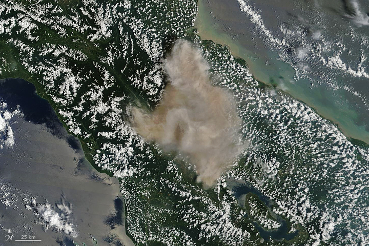
The Eruption of Sinabung Volcano, Indonesia, as seen from space. Credit: NASA Earth Observatory.
NASA’s Earth Observatory is a vital part of the space agency’s mission to advance our understanding of Earth, its climate, and the ways in which it is similar and different from the other Solar Planets. For decades, the EO has been monitoring Earth from space in order to map it’s surface, track it’s weather patterns, measure changes in our environment, and monitor major geological events.
For instance, Mount Sinabung – a stratovolcano located on the island of Sumatra in Indonesia – became sporadically active in 2010 after centuries of being dormant. But on February 19th, 2018, it erupted violently, spewing ash at least 5 to 7 kilometers (16,000 to 23,000 feet) into the air over Indonesia. Just a few hours later, Terra and other NASA Earth Observatory satellites captured the eruption from orbit.
The images were taken with Terra’s Moderate Resolution Imaging Spectroradiometer (MODIS), which recorded a natural-color image of the eruption at 11:10 am local time (04:10 Universal Time). This was just hours after the eruption began and managed to illustrate what was being reported by sources on the ground. According to multiple reports from the Associated Press, the scene was one of carnage.
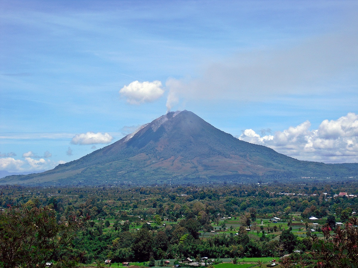
Mount Sinabung on September 13th, 2010, after it became sporatically-active again. Credit: Kenrick95/Wikipedia Commons
According to eye-witness accounts, the erupting lava dome obliterated a chunk of the peak as it erupted. This was followed by plumes of hot gas and ash riding down the volcano’s summit and spreading out in a 5-kilometer (3 mile) diameter. Ash falls were widespread, covering entire villages in the area and leading to airline pilots being issued the highest of alerts for the region.
In fact, ash falls were recorded as far as away as the town of Lhokseumawe – located some 260 km (160 mi) to the north. To address the threat to public health, the Indonesian government advised people to stay indoors due to poor air quality, and officials were dispatched to Sumatra to hand out face masks. Due to its composition and its particulate nature, volcanic ash is a severe health hazard.
On the one hand, it contains sulfur dioxide (SO²), which can irritate the human nose and throat when inhaled. The gas also reacts with water vapor in the atmosphere to produce acid rain, causing damage to vegetation and drinking water. It can also react with other gases in the atmosphere to form aerosol particles that can create thick hazes and even lead to global cooling.
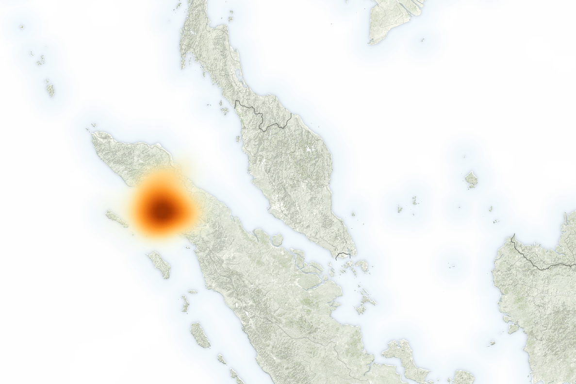
These levels were recorded by the Suomi-NPP satellite using its Ozone Mapper Profiler Suite (OMPS). The image below shows what SO² concentrations were like at 1:20 p.m. local time (06:20 Universal Time) on February 19th, several hours after the eruption. The maximum concentrations of SO² reached 140 Dobson Units in the immediate vicinity of the mountain.
Map showing concentrations of sulfur dioxide (SO²) due to the eruption of Mount Sinabung on the island of Sumatra, Indonesia. Credit: NASA/EO
Erik Klemetti, a volcanologist, was on hand to witness the event. As he explained in an article for Discovery Magazine:
“On February 19, 2018, the volcano decided to change its tune and unleashed a massive explosion that potentially reached at least 23,000 and possibly to up 55,000 feet (~16.5 kilometers), making it the largest eruption since the volcano became active again in 2013.”
Klemetti also cited a report that was recently filed by the Darwin Volcanic Ash Advisory Center – part of the Australian Government’s Bureau of Meteorology. According to this report, the ash will drift to the west and fall into the Indian Ocean, rather than continuing to rain down on Sumatra. Other sensors on NASA satellites have also been monitoring Mount Sinabung since its erupted.
In addition, data from the Aura satellite‘s Ozone Monitoring Instrument (OMI) recently indicated rising levels of SO² around Sinabung, which could mean that fresh magma is approaching the surface. As Erik Klemetti concluded:
“This could just be a one-off blast from the volcano and it will return to its previous level of activity, but it is startling to say the least. Sinabung is still a massive humanitarian crisis, with tens of thousands of people unable to return to their homes for years. Some towns have even been rebuilt further from the volcano as it has shown no signs of ending this eruptive period.”
Be sure to check out this video of the eruption, courtesy of New Zealand Volcanologist Dr. Janine Krippner:
The age of the oceanic crust - red is most recent, and blue is the oldest - which corresponds to the location of mid-ocean ridges. Credit: NCEI/NOAA
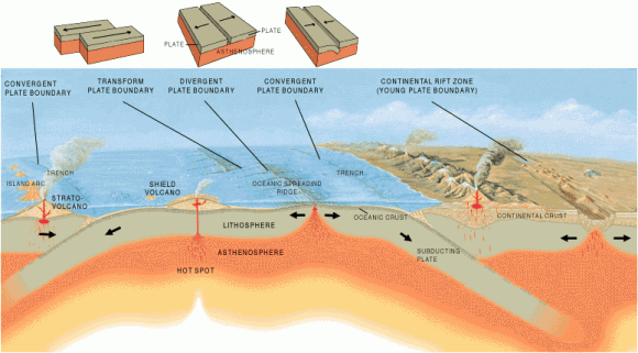
If you took geology in high school, then chances are you remember learning something about how the Earth’s crust – the outermost layer of Earth – is arranged into a series of tectonic plates. These plates float on top of the Earth’s mantle, the semi-viscous layer that surrounds the core, and are in constant motion because of convection in the mantle. Where two plates meet, you have what it is known as a boundary.
These can be “divergent” or “convergent”, depending on whether the plates are moving apart or coming together. Where they diverge, hot magma can rise from below, creating features like long ridges or mountain chains. Interestingly enough, this is how one of the world’s largest geological features was formed. It called the Mid-Atlantic Ridge, which run from north to south along the ocean floor in the Atlantic.
Description:
The Mid-Atlantic Ridge (MAR) is known as a mid-ocean ridge, an underwater mountain system formed by plate tectonics. It is the result of a divergent plate boundary that runs from 87° N – about 333 km (207 mi) south of the North Pole – to 54 °S, just north of the coast of Antarctica.
The different types of Tectonic Plate Boundaries, ranging from convergent and transform to divergent. Credit: USGS/Jose F. Vigil
Like other ocean ridge systems, the MAR developed as a consequence of the divergent motion between the Eurasian and North American, and African and South American Plates. In the North Atlantic, it separates the Eurasian and North American Plates; whereas in the South Atlantic, it separates the African and South American Plates.
The MAR is approximately 16,000 km (10,000 mi) long and between 1,000 and is 1,500 km (620 and 932 mi) wide. The peaks of the ridge stand about 3 km (1.86 mi) in height above the ocean floor, and sometimes reach above sea level, forming islands and island groups. The MAR is also part of the longest mountain chain in the world, extending continuously across the oceans floors for a total distance of 40,389 km (25,097 mi).
The MAR also has a deep rift valley at is crest which marks the location where the two plates are moving apart. This rift valley runs along the axis of the ridge for nearly its entire length, measuring some 80 to 120 km (50 to 75 miles) wide. The rift marks the actual boundary between adjacent tectonic plates, and is where magma from the mantle reaches the seafloor.
Where this magma is able to reach the surface, the result is basaltic volcanoes and islands. Where it is still submerged, it produces “pillow lava”. As the plates move further apart, new ocean lithosphere is formed at the ridge and the ocean basin gets wider. This process, known as “sea floor spreading”, is happening at an average rate of about 2.5 cm per year (1 inch).
The Earth’s Tectonic Plates, with convergent and divergent boundaries indicated with red arrows. Credit: msnucleus.org
In other words, North America and Europe are moving away from each other at a very slow rate. This process also means that the basaltic rock that makes up the ridge is younger than the surrounding crust.
Notable Features:
As noted, the ridge (while mainly underwater) does have islands and island groups that were created by volcanic activity. In the Northern Hemisphere, these include Jan Mayen Island and Iceland (Norway), and the Azores (Portugal). In the Southern Hemisphere, MAR features include Ascension Island, St. Helena, Tristan da Cunha, Gough Island (all UK territories) and Bouvet Island (Norway).
Near the equator, the Romanche Trench divides the North Atlantic Ridge from the South Atlantic Ridge. This narrow submarine trench has a maximum depth of 7,758 m (25,453 ft), one of the deepest locations of the Atlantic Ocean. This trench, however, is not regarded an official boundary between any of the tectonic plates.
History of Exploration:
The ridge was initially discovered in 1872 during the expedition of the HMS Challenger. In the course of investigating the Atlantic for the sake of laying the transatlantic telegraph cable, the crew discovered a large rise in the middle of the ocean floor. By 1925, its existence was confirmed thanks to the invention of sonar.
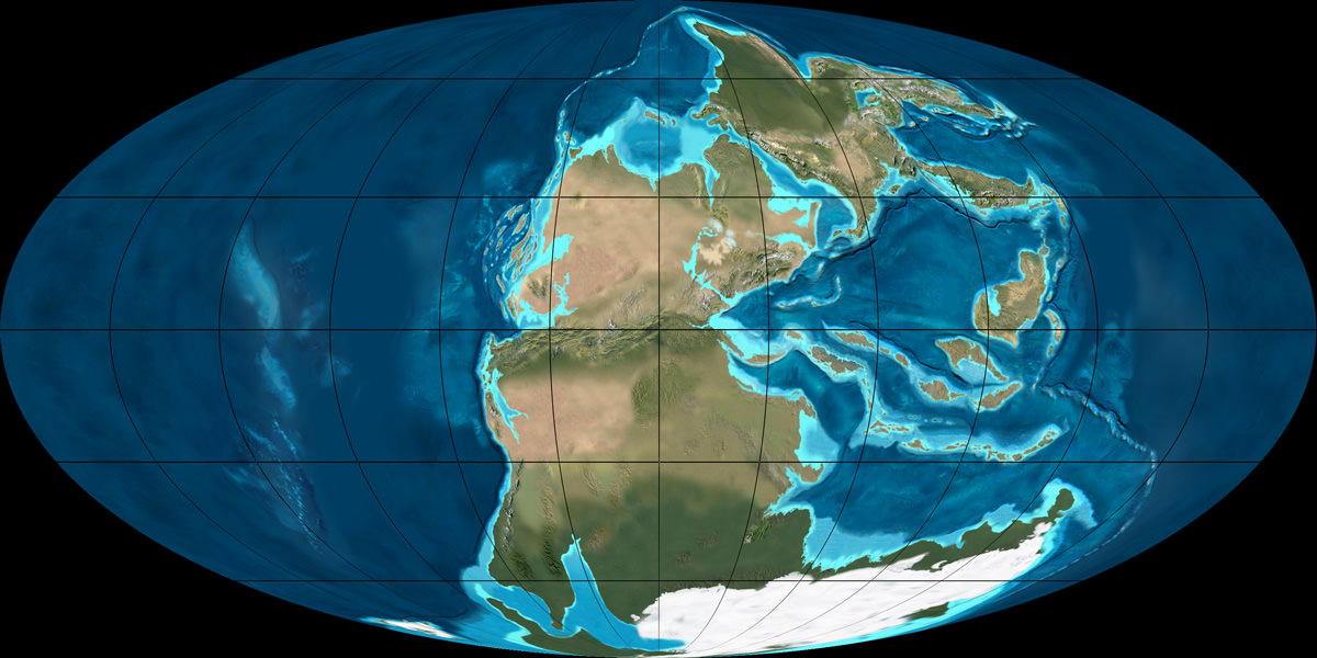
The super-continent Pangaea during the Permian period (300 – 250 million years ago). Credit: NAU Geology/Ron Blakey
By the 1960s, scientists were able to map the Earth’s ocean floors, which revealed a seismically-active central valley, as well as a network of valleys and ridges. They also discovered that the ridge was part of a continuous system of mid-ocean ridges that extended across the entire ocean floor, connecting all the divergent boundaries around the planet.
This discovery also led to new theories in terms of geology and planetary evolution. For instance, the theory of “seafloor spreading” was attributed to the discovery of the MAR, as was the acceptance of continental drift and plate tectonics. In addition, it also led to the theory that all the continents were once part of subcontinent known as “Pangaea”, which broke apart roughly 180 million years ago.
Much like the “Pacific Ring of Fire“, the discovery of the Mid-Atlantic Ridge has helped inform our modern understanding of the world. Similar to convergent boundaries, subduction zones and other geological forces, the process that created it is also responsible for the world as we know it today.
Basically, it is responsible for the fact that the Americas have been drifting away from Africa and Eurasia for millions of years, the formation of Australia, and the collision between the India Subcontinent and Asia. Someday – millions of years from now – the process of seafloor spreading will cause the Americas and Asia to collide, thus forming a new super continent – “Amasia”.
The Earth's layers, showing the Inner and Outer Core, the Mantle, and Crust. Credit: discovermagazine.com
Like all the other terrestrial planets, (Mercury, Venus, and Mars) the Earth is made up of many layers. This is the result of it undergoing planetary differentiation, where denser materials sink to the center to form the core while lighter materials form around the outside. Whereas the core is composed primarily of iron and nickel, Earth’s upper layer are composed of silicate rock and minerals.
This region is known as the mantle, and accounts for the vast majority of the Earth’s volume. Movement, or convection, in this layer is also responsible for all of Earth’s volcanic and seismic activity. Information about structure and composition of the mantle is either the result of geophysical investigation or from direct analysis of rocks derived from the mantle, or exposed mantle on the ocean floor.
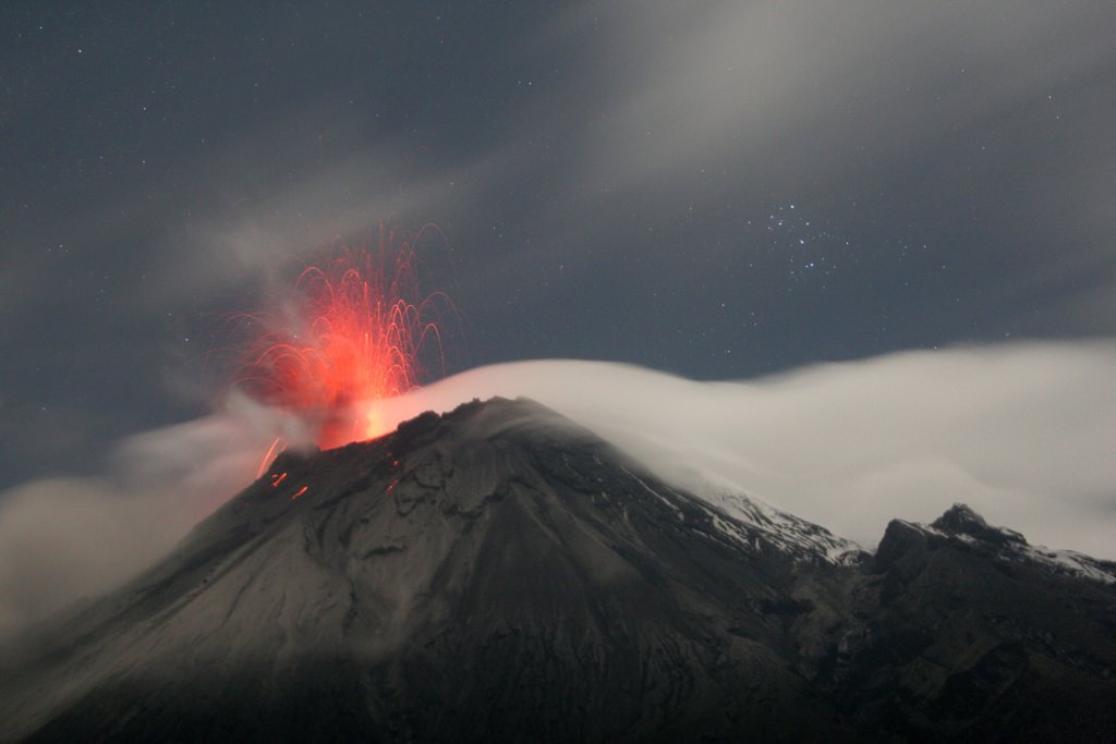
Tungurahua ("throat of fire"), an active stratovolcano in Ecuador. Credit: Patrick Taschler
Without a doubt, volcanoes are one of the most powerful forces of nature a person can bear witness to. Put simply, they are what results when a massive rupture takes place in the Earth’s crust (or any planetary-mass object), spewing hot lava, volcanic ash, and toxic fumes onto the surface and air. Originating from deep within the Earth’s crust, volcanoes leave a lasting mark on the landscape.
But what are the specific parts of a volcano? Aside from the “volcanic cone” (i.e. the cone-shaped mountain), a volcano has many different parts and layers, most of which are located within the mountainous region or deep within the Earth. As such, any true understanding of their makeup requires that we do a little digging (so to speak!)
While volcanoes come in a number of shapes and sizes, certain common elements can be discerned. The following gives you a general breakdown of a volcanoes specific parts, and what goes into making them such a titanic and awesome natural force.
Magma Chamber:
A magma chamber is a large underground pool of molten rock sitting underneath the Earth’s crust. The molten rock in such a chamber is under extreme pressure, which in time can lead to the surrounding rock fracturing, creating outlets for the magma. This, combined with the fact that the magma is less dense than the surrounding mantle, allows it to seep up to the surface through the mantle’s cracks.
Lava cooling after an eruption from Kilauea, a shield volcano near Kalapana, Hawaii Credit: kalapanaculturaltours.com
When it reaches the surface, it results in a volcanic eruption. Hence why many volcanoes are located above a magma chamber. Most known magma chambers are located close to the Earth’s surface, usually between 1 km and 10 km deep. In geological terms, this makes them part of the Earth’s crust – which ranges from 5–70 km (~3–44 miles) deep.
Lava:
Lava is the silicate rock that is hot enough to be in liquid form, and which is expelled from a volcano during an eruption. The source of the heat that melts the rock is known as geothermal energy – i.e. heat generated within the Earth that is leftover from its formation and the decay of radioactive elements. When lava first erupted from a volcanic vent (see below), it comes out with a temperature of anywhere between 700 to 1,200 °C (1,292 to 2,192 °F). As it makes contact with air and flows downhill, it eventually cools and hardens.
Main Vent:
A volcano’s main vent is the weak point in the Earth’s crust where hot magma has been able to rise from the magma chamber and reach the surface. The familiar cone-shape of many volcanoes are an indication of this, the point at which ash, rock and lava ejected during an eruption fall back to Earth around the vent to form a protrusion.
Throat:
The uppermost section of the main vent is known as the volcano’s throat. As the entrance to the volcano, it is from here that lava and volcanic ash are ejected.
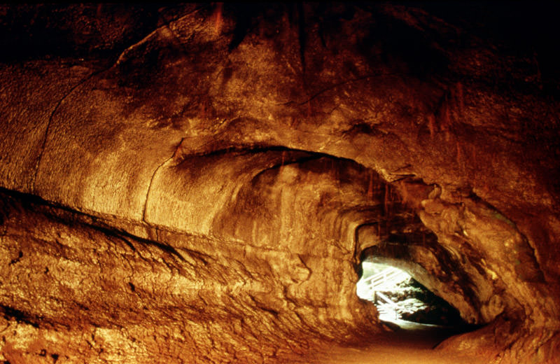
Thurston lava tube is located on Kilauea in Hawaii. Credit: P. Mouginis-Mark, LPI
Crater:
In addition to cone structures, volcanic activity can also lead to circular depressions (aka. craters) forming in the Earth. A volcanic crater is typically a basin, circular in form, which can be large in radius and sometimes great in depth. In these cases, the lava vent is located at the bottom of the crater. They are formed during certain types of climactic eruptions, where the volcano’s magma chamber empties enough for the area above it to collapse, forming what is known as a caldera.
Pyroclastic Flow:
Otherwise known as a pyroclastic density current, a pyroclastic flow refers to a fast-moving current of hot gas and rock that is moving away from a volcano. Such flows can reach speeds of up to 700 km/h (450 mph), with the gas reaching temperatures of about 1,000 °C (1,830 °F). Pyroclastic flows normally hug the ground and travel downhill from their eruption site.
Their speeds depend upon the density of the current, the volcanic output rate, and the gradient of the slope. Given their speed, temperature, and the way they flow downhill, they are one of the greatest dangers associated with volcanic eruptions and are one of the primary causes of damage to structures and the local environment around an eruption site.
Ash Cloud:
Volcanic ash consists of small pieces of pulverized rock, minerals and volcanic glass created during a volcanic eruption. These fragments are generally very small, measuring less than 2 mm (0.079 inches) in diameter. This sort of ash forms as a result of volcanic explosions, where dissolved gases in magma expand to the point where the magma shatters and is propelled into the atmosphere. The bits of magma then cool, solidifying into fragments of volcanic rock and glass.
Because of their size and the explosive force with which they are generated, volcanic ash is picked up by winds and dispersed up to several kilometers away from the eruption site. Due to this dispersal, ash an also have a damaging effect on the local environment, which includes negatively affecting human and animal health, disrupting aviation, disrupting infrastructure, and damaging agriculture and water systems. Ash is also produced when magma comes into contact with water, which causes the water to explosively evaporate into steam and for the magma to shatter.
Volcanic Bombs:
In addition to ash, volcanic eruptions have also been known to send larger projectiles flying through the air. Known as volcanic bombs, these ejecta are defined as those that measure more than 64mm (2.5 inches) in diameter, and which are formed when a volcano ejects viscous fragments of lava during an eruption. These cool before they hit the ground, are thrown many kilometers from the eruption site, and often acquire aerodynamic shapes (i.e. streamlined in form).
While the term applies to any ejecta larger than a few centimeters, volcanic bombs can sometimes be very large. There have been recorded instances where objects measuring several meters were retrieved hundreds of meters from an eruptions. Small or large, volcanic bombs are a significant volcanic hazard and can often cause serious damage and multiple fatalities, depending on where they land. Luckily, such explosions are rare.
Secondary Vent:
On large volcanoes, magma can reach the surface through several different vents. Where they reach the surface of the volcano, they form what is referred to as a secondary vent. Where they are interrupted by accumulated ash and solidified lava, they become what is known as a Dike. And where these intrude between cracks, pool and then crystallize, they form what is called a Sill.
Cross-section of a stratovolcano: 1. Magma chamber 2. Bedrock 3. Vent 4. Base 5. Sill 6. Dike 7. Layers of ash 8. Flank 9. Layers of lava 10. Throat 11. Parasitic cone 12. Lava flow 13. Vent 14. Crater 15. Ash cloud. Credit: MesserWoland
Secondary Cone:
Also known as a Parasitic Cone, secondary cones build up around secondary vents that reach the surface on larger volcanoes. As they deposit lava and ash on the exterior, they form a smaller cone, one that resembles a horn on the main cone.
Yes indeed, volcanoes are as powerful as they are dangerous. And yet, without these geological phenomena occasionally breaking through the surface and reigning down fire, smoke, and clouds of ash, the world as we know it would be a very different place. More than likely, it would be a geologically dead one, with no change or evolution in its crust. I think we can all agree that while such a world would be much safer, it would also be painfully boring!
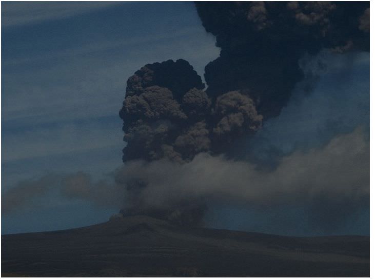
Sarychev volcano, (located in Russia's Kuril Islands, northeast of Japan) in an early stage of eruption on June 12, 2009. Credit: NASA
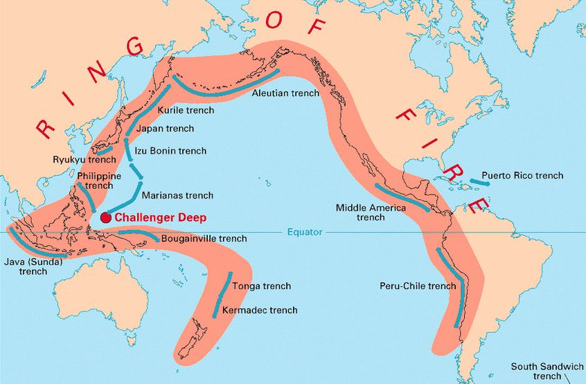
What if someone were to tell you that there’s a region in the world where roughly 90% of the world’s earthquakes occur. What if they were to tell you that this region is also home to over 75% of the world’s active and dormant volcanoes, and all but 3 of the world’s 25 largest eruptions in the last 11,700 years took place here.
Chances are, you’d think twice about buying real-estate there. But strangely enough, hundreds of millions of people live in this area, and some of the most densely-packed cities in the world have been built atop its shaky faults. We are talking about the Pacific Ring of Fire, a geologically and volcanically active region that stretches from one side of the Pacific to the other.
Definition:
Also known as the circum-Pacific belt, the “Ring of Fire” is a 40,000 km (25,000 mile) horseshoe-shaped basin that is associated with a nearly continuous series of oceanic trenches, volcanic arcs, and volcanic belts and/or plate movements. This ring accounts for 452 volcanoes (active and dormant), stretching from the southern tip of South America, up along the coast of North America, across the Bering Strait, down through Japan, and into New Zealand – with several active and dormant volcanoes in Antarctica closing the ring.
Tectonic Activity:
The Ring of Fire is the direct result of plate tectonics and the movement and collisions of lithospheric plates. These plates, which constitute the outer layer of the planet, are constantly in motion atop the mantle. Sometimes they collide, pull apart, or slide alongside each other; resulting in convergent boundaries, divergent boundaries, and transform boundaries.
The Pacific Ring of Fire, a string of volcanic regions extending from the South Pacific to South America. Credit: Public Domain
In the case of the former, subduction zones are often the result, where the heavier plate slips under the lighter plate – forming a deep trench. This subduction changes the dense mantle into buoyant magma, which rises through the crust to the Earth’s surface. Over millions of years, this rising magma creates a series of active volcanoes known as a volcanic arc.
These ocean trenches and volcanic arcs run parallel to one another. For instance, the Aleutian Islands in the U.S. state of Alaska run parallel to the Aleutian Trench. Both geographic features continue to form as the Pacific Plate subducts beneath the North American Plate. Meanwhile, the Andes Mountains of South America run parallel to the Peru-Chile Trench, created as the Nazca Plate subducts beneath the South American Plate.
In the case of divergent boundaries, these are formed when tectonic plates pull apart, forming rift valleys on the seafloor. When this happens, magma wells up in the rift as the old crust pulls itself in opposite directions, where it is cooled by seawater to form new crust. This upward movement and eventual cooling of this magma has created high ridges on the ocean floor over millions of years.
The East Pacific Rise is a site of major seafloor spreading in the Ring of Fire, located on the divergent boundary of the Pacific Plate and the Cocos Plate (west of Central America), the Nazca Plate (west of South America), and the Antarctic Plate. The largest known group of volcanoes on Earth is found underwater along the portion of the East Pacific Rise between the coasts of northern Chile and southern Peru.
The different type of tectonic plate boundaries. Credit: oceanexplorer.noaa.gov
A transform boundary is formed when tectonic plates slide horizontally and parts get stuck at points of contact. Stress builds in these areas as the rest of the plates continue to move, which causes the rock to break or slip, suddenly lurching the plates forward and causing earthquakes. These areas of breakage or slippage are called faults, and the majority of Earth’s faults can be found along transform boundaries in the Ring of Fire.
The San Andreas Fault, stretching along the central west coast of North America, is one of the most active faults on the Ring of Fire. It lies on the transform boundary between the North American Plate, which is moving south, and the Pacific Plate, which is moving north. Measuring about 1,287 kilometers (800 miles) long and 16 kilometers (10 miles) deep, the fault cuts through the western part of the U.S. state of California.
Plate Boundaries:
The eastern section of the Ring of Fire is the result of the Nazca Plate and the Cocos Plate being subducted beneath the westward moving South American Plate. Meanwhile, the Cocos Plate is being subducted beneath the Caribbean Plate, in Central America. A portion of the Pacific Plate along with the small Juan de Fuca Plate are being subducted beneath the North American Plate.
Along the northern portion, the northwestward-moving Pacific plate is being subducted beneath the Aleutian Islands arc. Farther west, the Pacific plate is being subducted along the Kamchatka Peninsula arcs on south past Japan.
The Earth’s Tectonic Plates. Credit: msnucleus.org
The southern portion is more complex, with a number of smaller tectonic plates in collision with the Pacific plate from the Mariana Islands, the Philippines, Bougainville, Tonga, and New Zealand. This portion excludes Australia, since it lies in the center of its tectonic plate.
Indonesia lies between the Ring of Fire along the northeastern islands adjacent to and including New Guinea and the Alpide belt along the south and west from Sumatra, Java, Bali, Flores, and Timor. The famous and very active San Andreas Fault zone of California is a transform fault which offsets a portion of the East Pacific Rise under southwestern United States and Mexico.
Volcanic Activity:
Most of the active volcanoes on The Ring of Fire are found on its western edge, from the Kamchatka Peninsula in Russia, through the islands of Japan and Southeast Asia, to New Zealand. Mount Ruapehu in New Zealand is one of the more active volcanoes in the Ring of Fire, with yearly minor eruptions, and major eruptions occurring about every 50 years.
Krakatau, perhaps better known as Krakatoa, is an island volcano in Indonesia. Krakatoa erupts less often than Mount Ruapehu, but much more spectacularly. Beneath Krakatoa, the denser Australian Plate is being subducted beneath the Eurasian Plate. An infamous eruption in 1883 destroyed the entire island, sending volcanic gas, volcanic ash, and rocks as high as 80 kilometers (50 miles) in the air. A new island volcano, Anak Krakatau, has been forming with minor eruptions ever since.
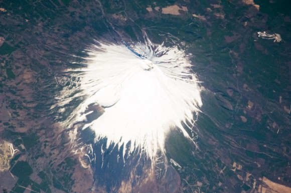
Mount Fuji, Japan, as seen from the ISS. Credit: NASA
Mount Fuji, Japan’s tallest and most famous mountain, is an active volcano in the Ring of Fire. Mount Fuji last erupted in 1707, but recent earthquake activity in eastern Japan may have put the volcano in a “critical state.” Mount Fuji sits at a “triple junction,” where three tectonic plates (the Amur Plate, Okhotsk Plate, and Philippine Plate) interact.
The Ring of Fire’s eastern half also has a number of active volcanic areas, including the Aleutian Islands, the Cascade Mountains in the western U.S., the Trans-Mexican Volcanic Belt, and the Andes Mountains. Mount St. Helens, in the U.S. state of Washington, is an active volcano in the Cascade Mountains.
Below Mount St. Helens, both the Juan de Fuca and Pacific plates are being subducted beneath the North American Plate. Its historic 1980 eruption lasted 9 hours and covered 11 U.S. states with tons of volcanic ash. The eruption caused the deaths of 57 people, over a billion dollars in property damage, and reduced hundreds of square miles to wasteland.
Popocatépetl is one of the most active and dangerous volcanoes in the Ring of Fire, with 15 recorded eruptions since 1519. The volcano lies on the Trans-Mexican Volcanic Belt, which is the result of the small Cocos Plate subducting beneath the North American Plate. Located close to the urban areas of Mexico City and Puebla, Popocatépetl poses a risk to the more than 20 million people that live close enough to be threatened by a destructive eruption.
Map of the Earth showing the relation between fault lines (blue) and zones of volcanic activity (red). Credit: zmescience.com
Earthquakes:
Scientists have known for some time that the majority of the seismic activity occurs along plate boundaries. Hence why roughly 90% of the world’s earthquakes – which is estimated to be around 500,000 a year, one-fifth of which are detectable – occur around the Pacific Rim, where multiple plate boundaries exist.
As a result, earthquakes are a regular occurrence in places like Japan, Indonesia and New Zealand in Asia and the South Pacific; Alaska, British Columbia, California and Mexico in North America; and El Salvador, Guatemala, Peru and Chile in Central and South America. Where fault lines run beneath the ocean, larger earthquakes in these regions also trigger tsunamis.
The most well-known tsumanis to take place in the Ring of Fire include the 2004 Indian Ocean earthquake and tsunami. This was the most devastating tsunami of its kind in modern times, killing around 230,000 people and laying waste to communities throughout Indonesia, Thailand, and Southern Asia.
In 2010, an earthquake triggered a tsunami which caused 4334 confirmed deaths and devastating several coastal towns in south-central Chile, including the port at Talcahuano. The earthquake also generated a blackout that affected 93 percent of the Chilean population.
In 2011, an earthquake off the Pacific coast of Tohoku led to a tsunami that struck Japan and led to 5,891 deaths, 6,152 injuries, and 2,584 people to be declared missing across twenty prefectures. The tsunami also caused meltdowns at three reactors in the Fukushima Daiichi Nuclear Power Plant complex.
The Ring of Fire is a crucial region for many reasons. It serves as one of the main boundary regions for the tectonic plates of over half of the globe. It also affects the lives of millions if not billions of people who live in these regions. For many of the people who live in the Pacific Ring of Fire, the reality of a volcanic eruption or earthquake is commonplace and a challenge they have come to deal with over time.
At the same time, the volcanic activity has also provided many valuable resources, such as rich farmland and the possibility of tapping geothermal activity for heating and electricity. As always, nature gives with one hand and takes with the other!
If you have enjoyed this article there are several others on Universe Today that you will find interesting. Here is one called 10 Interesting Facts About Volcanoes. There is also a great article about plate tectonics.
You can also find some good resources online. There is a companion site for the PBS program Savage Earth that talks about the Ring of Fire. You can also check out the USGS site to see a detailed map of the Pacific Ring of Fire and more detailed information about plate tectonics.
You can also listen to Astronomy Cast. Episode 141 talks about volcanoes.
The Pacific Ring of Fire, a strong of volcanic . Credit:
The Pacific Ring of Fire wraps around the Pacific Ocean, including countries like Japan, Canada, New Zealand and Chile. And the inhabitants within those countries are prone to… oh… killer earthquakes, volcanoes and tsunamis. Let’s chat about the history of this region and the kinds of risks they face.
And the podcast is also available as a video, as Fraser and Pamela now record Astronomy Cast as part of a Google+ Hangout (usually recorded every Monday at 3 pm Eastern Time):
[/caption]Mount Krakatoa is a volcanic island found in Indonesia. Its most famous eruption in 1883 is one of the biggest in recorded history. You guessed it right; Krakatoa belongs to the Pacific Ring of Fire, the volatile horseshoe-shaped area bordering the Pacific Ocean.
Better known as Krakatau in Indonesia, its eruption in 1883 produced a series of tsunamis that smashed into 165 coastal villages in Java and Sumatra. 36,000 people perished when those giant waves hit. Most of those who were killed during the 1883 eruption, which lasted for two days (Aug 26 to 27), were actually victims of the tsunamis.
Some of the giant waves from that eruption, which rose up to 40 meters, managed to reach the southern part of the Arabian Peninsula, some 7,000 km away. When the 2004 Indian Ocean Tsunami (a.k.a. the 2004 Indonesian Tsunami) struck, it reminded the scientific community of the 1883 eruption because of the proximity of their points of origin.
The eruption also had a large impact on the global climate. On the average, temperature dropped by as much as 1.2ºC in the succeeding year. In the years that followed, global climates were very erratic, stabilizing only 4 years after.
Mount Krakatoa’s lava was known to be made of dacite or rhyolite. This explains the magnitude of its eruption. Generally speaking, volcanic eruptions are more explosive if their lava is composed of dacite or rhyolite. They are cooler and stickier than basalt, allowing them to accumulate pressure before being set free.
Although the 1883 eruption destroyed more than 60% of the volcanic island, a submarine eruption in 1927 produced a new island in its stead. This volcano is aptly called Anak Krakatau, which is Indonesian for “Child of Krakatoa”. Anak Krakatau’s radius is estimated to be 2 kilometers and rises up to a maximum height of 300 meters above sea level. Studies have shown in to be growing at a rate of 5 meters per year.
Before 1883, three volcanoes known as Rakata, Danan, and Perbuwatan combined to what then became Krakatoa island.
Mount Krakatoa is an example of a stratovolcano, a tall, conical volcano with multiple strata of solidified lava, tephra, as well as volcanic ash. These type of volcanoes typically have steep sides and usually erupt frequently & violently. Most of the popular eruptions have been made by stratovolcanoes. Other known stratovolcanoes are Mount St. Helens and Mount Pinatubo.
Indonesia is the country that holds the biggest number of active volcanoes, at 130. Iceland, another volcano-dotted country, holds about the same number (of volcanoes) but not all are as active as those in Indonesia.
We have some articles in Universe Today that are related to Mount Krakatoa. Here are two of them: