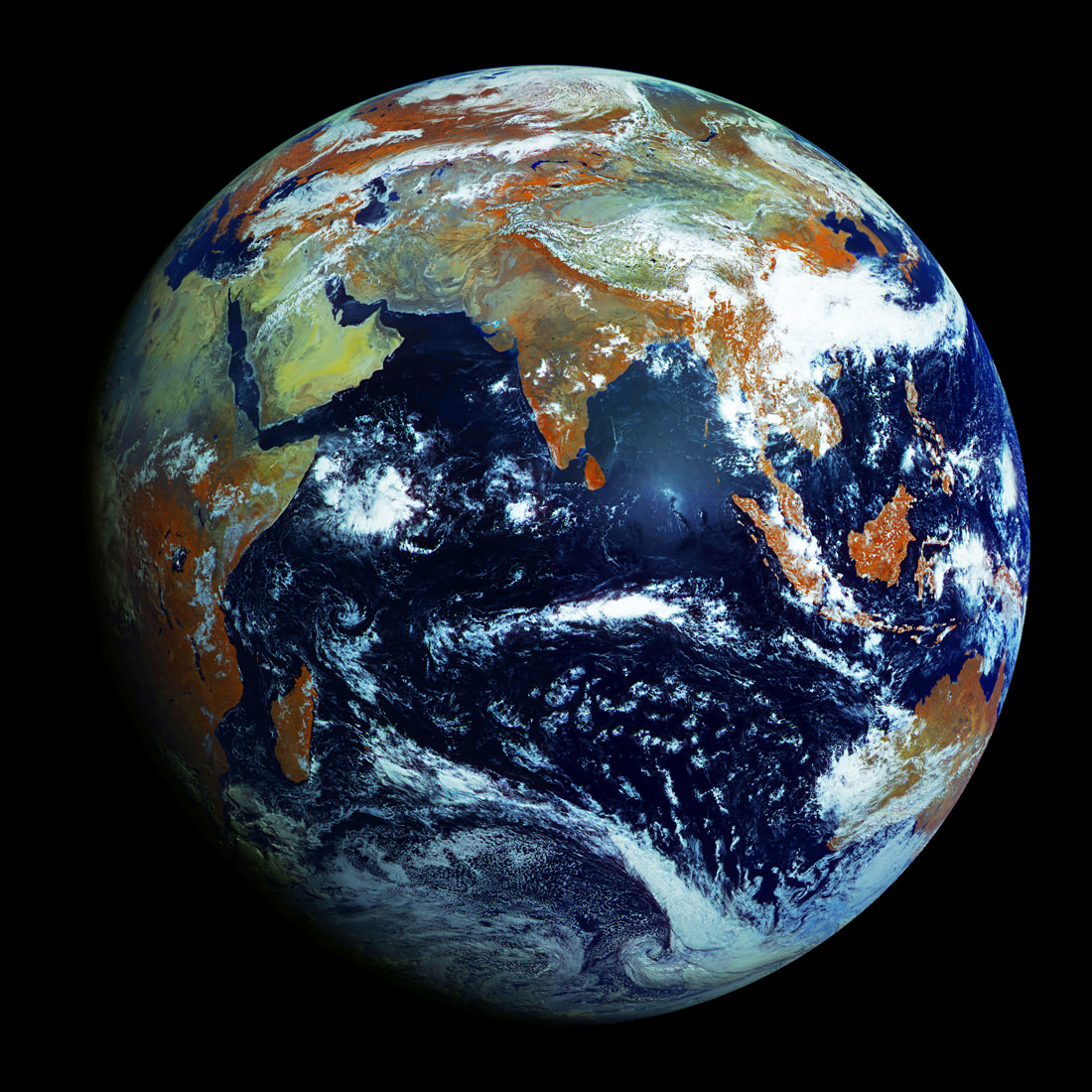
Full-disk image of Earth from Russia's Elektro-L satellite. (NTs OMZ)
[/caption]
Unlike most satellite images of Earth, this one was not assembled from multiple swath scans or digitally projected onto a globe model — it’s the full disk of our planet in captured as a single, enormous 121 megapixel image, acquired by Russia’s Elektro-L weather-forecasting satellite.
Like NASA’s GOES satellites, Elektro-L is parked in a geostationary orbit approximately 36,000 km (22,300 miles) above our planet. Unlike NASA’s satellites, however, Elektro-L captures images in near-infrared as well as visible wavelengths, providing detail about not only cloud movement but also vegetation variations. Its wide-angle Multichannel Scanning Unit (MSU) takes images every 15-30 minutes, showing the same viewpoint of Earth across progressive times of the day.
At a resolution of 0.62 miles per pixel, full-size Elektro-L images are some of the most detailed images of Earth acquired by a weather satellite.
Download the full-size image here (100+ megabytes).
Launched aboard a Zenit rocket on January 20, 2011, Elektro-L was the first major spacecraft to be developed in post-Soviet Russia. Parked over Earth at 76 degrees east longitude, Elektro-L provides local and global weather forecasting and analysis of ocean conditions, as well as “space weather” monitoring — measurements of solar radiation and how it interacts with Earth’s magnetic field. Its initial lifespan is projected to be ten years.
A second Elektro-L satellite is anticipated to launch in 2013.
Image credit: Russian Federal Space Agency / Research Center for Earth Operative Monitoring (NTS OMZ). See more images and video from Elektro-L on James Drake’s Planet Earth here. (Tip of the geostationary hat to Jesus Diaz at Gizmodo.)
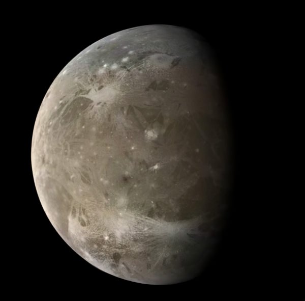
Galileo image of Ganymede, Jupiter's - and the Solar System's - largest moon. (Ted Stryk)
[/caption]
The European Space Agency has given the go-ahead for an exciting mission to explore the icy moons of Jupiter, as well as the giant planet itself.
JUICE — JUpiter ICy moons Explorer — will consist of a solar-powered spacecraft that will spend 3.5 years within the Jovian system, investigating Ganymede, Europa and the upper atmosphere of Jupiter. Anticipated to launch in June 2022, JUICE would arrive at Jupiter in early 2030.
As its name implies, JUICE’s main targets are Jupiter’s largest icy moons — Ganymede and Europa — which are thought to have liquid oceans concealed beneath their frozen surfaces.
The largest moon in the Solar System, Ganymede is also thought to have a molten iron core generating a magnetic field much like Earth’s. The internal heat from this core may help keep Ganymede’s underground ocean liquid, but the dynamics of how it all works are not quite understood.
JUICE will also study the ice-coated Europa, whose cueball-smooth surface lined with cracks and jumbled mounds of frozen material seem to be sure indicators of a subsurface ocean, although how deep and how extensive is might be are still unknown — not to mention its composition and whether or not it could be hospitable to life.
The rust-colored cracks lining Europa's otherwise smooth surface hint at a subsurface ocean. (Ted Stryk)
“JUICE will give us better insight into how gas giants and their orbiting worlds form, and their potential for hosting life,” said Professor Alvaro Giménez Cañete, ESA’s Director of Science and Robotic Exploration.
The JUICE spacecraft was originally supposed to join a NASA mission dedicated to the investigation of Europa, but NASA deemed their proposed mission too costly and it was cancelled. According to Robert Pappalardo, study scientist for the Europa mission based at JPL, NASA may still supply some instruments for the spacecraft “assuming that the funding situation in the United States can bear it.”
Artist's rendering of JUICE at Jupiter. (ESA/AOES)
JUICE will also capture images of Jupiter’s moon Callisto and search for aurorae in the gas giant’s upper atmosphere, as well as measure the planet’s powerful magnetic field. Once arriving in 2030, it will spend at least three years exploring the Jovian worlds.
Read more in today’s news release from Nature, and stay tuned to ESA’s JUICE mission page here.
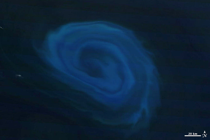
Tendrils of ice particles, called frazil, extend out into Antarctica's Mackenzie Bay. (NASA/EO-1 - ALI)
[/caption]
Ghostly green tendrils drift out into Mackenzie Bay off the coast of eastern Antarctica in this image, acquired by NASA’s Earth-Observing (EO-1) satellite on Feb. 12, 2012.
The tendrils are made of fine particles of ice called frazil, the result of upwelling cold water from deep beneath the Amery ice shelf.
Sea water flowing in currents under the Amery ice shelf gets cooled to temperatures below freezing, the result of greater water pressures existing at depth. As some of the water rises and flows along the underside of the shelf toward the open ocean, it gradually encounters less pressure since the ice thickness decreases the further away from shore it extends.
When the supercold water approaches the surface where pressure is lowest, it instantly freezes, forming needle-like ice particles called frazil.
Only 3 -4 millimeters wide, the frazil crystals can still be concentrated enough to be visible from orbit as it drifts into the bay, flowing around icebergs as it is carried along by wind and currents. (The largest iceberg in the image is a little over 4 km/2.5 miles long.)
Eventually the warmer surface water that surrounds the southern continent melts the frazil, and the tendrils fade away.
Scheduled to fly for a year and only designed to last a year and a half, EO-1 celebrated its eleventh anniversary on November 21, 2011. During its time in orbit the satellite has accomplished far more than anyone dreamed, and its Earth-observing mission continues on. Read more on the EO-1 site here.
A 150-km (93-mile) - wide eddy in the southern Indian Ocean. (NASA/Terra-MODIS)
[/caption]
A serpentine eddy swirls in the southern Indian Ocean several hundred kilometers off the coast of South Africa in this natural-color image, acquired by NASA’s Terra satellite on December 26, 2011.
The blue color is created by blooms of phytoplankton, fertilized by the nutrient-rich deep water drawn up by the 150-km-wide eddy.
The counter-clockwise anticyclonic structure of the eddy may resemble a hurricane or typhoon, but unlike those violent storms eddies bring nourishment rather than destruction.
“Eddies are the internal weather of the sea,” said Dennis McGillicuddy, an oceanographer at the Woods Hole Oceanographic Institution in Massachusetts.
And also unlike atmospheric storms, ocean eddies can last for months, even up to a year. The largest ones can contain up to 1,200 cubic miles (5,000 cubic kilometers) of water.
The nutrient-drawing power of eddies can supply the relatively barren waters of the open ocean with nutrients, creating “oases in the oceanic desert,” according to McGillicuddy.
The eddy imaged here likely peeled off from the Agulhas Current, which flows along the southeastern coast of Africa and around the tip of South Africa. Agulhas eddies tend to be among the largest in the world.
The image below shows the eddy in context with the surrounding area:
Eddy off the coast of South Africa. December 26, 2011. (NASA/Terra-MODIS)
MODIS (or Moderate Resolution Imaging Spectroradiometer) is a key instrument aboard NASA’s Terra (EOS AM) satellite. Terra MODIS views the entire Earth’s surface every 1 to 2 days, acquiring data in 36 spectral bands. These data improve our understanding of global dynamics and processes occurring on the land, in the ocean, and in the lower atmosphere.
Artist's rendering of the KM3NeT array. (Marco Kraan/Property KM3NeT Consortium)
[/caption]
The hunt for elusive neutrinos will soon get its largest and most powerful tool yet: the enormous KM3NeT telescope, currently under development by a consortium of 40 institutions from ten European countries. Once completed KM3NeT will be the second-largest structure ever made by humans, after the Great Wall of China, and taller than the Burj Khalifa in Dubai… but submerged beneath 3,200 feet of ocean!
KM3NeT – so named because it will encompass an area of several cubic kilometers – will be composed of lengths of cable holding optical modules on the ends of long arms. These modules will stare at the sea floor beneath the Mediterranean in an attempt to detect the impacts of neutrinos traveling down from deep space.
Successfully spotting neutrinos – subatomic particles that don’t interact with “normal” matter very much at all, nor have magnetic charges – will help researchers to determine which direction they originated from. That in turn will help them pinpoint distant sources of powerful radiation, like quasars and gamma-ray bursts. Only neutrinos could make it this far and this long after such events since they can pass basically unimpeded across vast cosmic distances.
“The only high energy particles that can come from very distant sources are neutrinos,” said Giorgio Riccobene, a physicist and staff researcher at the National Institute for Nuclear Physics. “So by looking at them, we can probe the far and violent universe.”
Each Digital Optical Module (DOM) is a standalone sensor module with 31 3-inch PMTs in a 17-inch glass sphere.
In effect, by looking down beneath the sea KM3NeT will allow scientists to peer outward into the Universe, deep into space as well as far back in time.
The optical modules dispersed along the KM3NeT array will be able to identify the light given off by muons when neutrinos pass into the sea floor. The entire structure would have thousands of the modules (which resemble large versions of the hovering training spheres used by Luke Skywalker in Star Wars.)
In addition to searching for neutrinos passing through Earth, KM3NeT will also look toward the galactic center and search for the presence of neutrinos there, which would help confirm the purported existence of dark matter.
Read more about the KM3NeT project here, and check out a detailed article on the telescope and neutrinos on Popsci.com.
Height of the KM3NeT telescope structure compared to well-known buildings
2 billion years ago Mars may have featured a frigid ocean. Credit: Taylor Perron/UC Berkeley.
[/caption]
Many planetary scientists suspect that Mars, now cold and very dry, once had a liquid water ocean covering parts of its surface. But this does not necessarily mean that the Red Planet was ever a tropical paradise… a recent paper by a team of astrobiologists suggests that Mars was much more bitter than balmy.
Astrobiologist Alberto Fairyn and colleagues have published a paper in the journal Nature Geoscience suggesting that the marked absence of phyllosilicates in Mars’ northern lowlands is indicative of a cold ocean environment, with perhaps even a boundary of frozen glaciers.
Phyllosilicates are minerals that, on Earth, are found readily in marine sediments and sedimentary rock that was formed in the presence of an ocean environment. These same minerals have also been seen via orbiting spacecraft spectrometers to be present in sediments located in Mars’ equatorial regions, but not in the northern latitudes. Fairyn and his team, intrigued by the disparity between existing models that described Mars as being once warm and wet and the lack of phyllosilicates in the north, used new climatic and geochemical models to deduce that Mars’ northern oceans must have been consistently near freezing, with portions even covered over by ice.
The current presence of moraines in the northern highlands also suggests that glaciers may have surrounded these frigid seas, which may have prevented the transportation of phyllosilicates down to the northern ocean basin. Again, to use our own planet as an analogy, moraines are rocky debris left over from the movement of glaciers. Their existence on Mars strongly suggests a period of early glaciation.
The research by Fairyn et al. contradict – or, more aptly, combine – two leading concepts of early Mars: one, that it was cold and dry and the existence of any liquid water was restricted to the equator for small periods of time; and two, that it was once globally warmer and wetter and sustained rivers, lakes and oceans of liquid water for extended periods.
Thus a cold Mars with an Arctic, icy ocean seems to be a more fitting causation of the current state of the planet, suggests Fairyn.
More research is planned, including running through more low-temperature models and hunting for ancient coastal areas that may have been impacted by icebergs. This will no doubt prove to be a challenge since much of the evidence is now buried deep beneath newer sediments and volcanic deposits. Still, Fairyn is confident that his model may help solve a long-standing debate over the history of the Red Planet.
Jason Major is a graphic designer, photo enthusiast and space blogger. Visit his website Lights in the Dark and follow him on Twitter @JPMajor or on Facebook for the most up-to-date astronomy awesomeness!
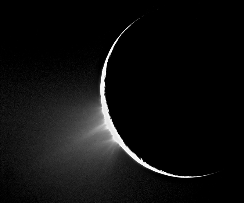
Enceladus' signature ice geysers in action. NASA / JPL / SSI
[/caption]
Researchers on the Cassini mission team have identified large salt grains in the plumes emanating from Saturn’s icy satellite Enceladus, making an even stronger case for the existence of a salty liquid ocean beneath the moon’s frozen surface.
Cassini first discovered the jets of water ice particles in 2005; since then scientists have been trying to learn more about how they behave, what they are made of and – most importantly – where they are coming from. The running theory is that Enceladus has a liquid subsurface ocean of as-of-yet undetermined depth and volume, and pressure from the rock and ice layers above combined with heat from within force the water up through surface cracks near the moon’s south pole. When this water reaches the surface it instantly freezes, sending plumes of ice particles hundreds of miles into space.
Enceladus inside the E ring
Much of the ice ends up in orbit around Saturn, creating the hazy E ring in which Enceladus resides.
Although the discovery of the plumes initially came as a surprise, it’s the growing possibility of liquid water that’s really intriguing – especially that far out in the Solar System and on a little 504-km-wide moon barely the width of Arizona. What’s keeping Enceladus’ water from freezing as hard as rock? It could be tidal forces from Saturn, it could be internal heat from its core, a combination of both – or something else entirely… astronomers are still hard at work on this mystery.
Now, using data obtained from flybys in 2008 and 2009 during which Cassini flew directly through the plumes, researchers have found that the particles in the jets closest to the moon contain large sodium- and potassium-rich salt grains. This is the best evidence yet of the existence of liquid salt water inside Enceladus – a salty underground ocean.
“There currently is no plausible way to produce a steady outflow of salt-rich grains from solid ice across all the tiger stripes other than salt water under Enceladus’s icy surface.”
– Frank Postberg, Cassini team scientist, University of Heidelberg, Germany
Looking down into a jetting "tiger stripe"
If there indeed is a reservoir of liquid water, it must be pretty extensive since the numerous plumes are constantly spraying water vapor at a rate of 200 kg (400 pounds) every second – and at several times the speed of sound! The plumes are ejected from points within long, deep fissures that slash across Enceladus’ south pole, dubbed “tiger stripes”.
Recently the tiger stripe region has also been found to be emanating a surprising amount of heat, even further supporting a liquid water interior – as well as an internal source of energy. And where there’s liquid water, heat energy and organic chemicals – all of which seem to exist on Enceladus – there’s also a case for the existence of life.
“This finding is a crucial new piece of evidence showing that environmental conditions favorable to the emergence of life can be sustained on icy bodies orbiting gas giant planets.”
– Nicolas Altobelli, ESA project scientist for Cassini
Enceladus has intrigued scientists for many years, and every time Cassini takes a closer look some new bit of information is revealed… we can only imagine what other secrets this little world may hold. Thankfully Cassini is going strong and more than happy to keep on investigating!
“Without an orbiter like Cassini to fly close to Saturn and its moons — to taste salt and feel the bombardment of ice grains — scientists would never have known how interesting these outer solar system worlds are.”
– Linda Spilker, Cassini project scientist at JPL
The findings were published in this week’s issue of the journal Nature.
Image credits: NASA / JPL / Space Science Institute
__________________
Jason Major is a graphic designer, photo enthusiast and space blogger. Visit his website Lights in the Dark and follow him on Twitter @JPMajor or on Facebook for the most up-to-date astronomy awesomeness!
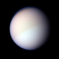
Titan holds yet more secrets, far beneath its haze...
[/caption]
Saturn’s moon Titan just keeps throwing surprises at us. A multi-layered atmosphere thicker than our own? Check. A hydrologic cycle that relies on methane as the operating liquid? Check. Rivers, streams and lakes filled with this same liquid? Check, check and check. And now, scientists are suspecting that Titan may have yet another surprise: a subsurface ocean.
Observations of Titan’s rotation and orbit, carried out by researchers at the Royal Observatory of Belgium using Cassini data, point at an unusual rotational inertia; that is, its resistance to changes in its motion, also known as moment of inertia or angular mass. Basically Titan moves in a way that is not indicative of a solid body of its previously assumed density and mass. Rather, its motion – both around its own axis and in its tidally-locked orbit around Saturn – are more in line with an object that isn’t uniformly solid.
Titan's thick clouds hide its surface well. NASA / JPL / SSI / J.Major
According to the math, Titan may very well be filled with liquid!
Or, at least, have a liquid layer of considerable depth beneath its surface. How far below the surface, how deep and exactly what kind of liquid are all speculative at this point…it’s suggested that it may be a subsurface ocean of yet more methane. This would help answer the question of where Titan gets all of its methane in the first place; methane, – a.k.a. natural gas – is a compound that breaks down quickly in sunlight. In fact, the high-level haze that surrounds the moon like a wispy blue shell is made up of this broken-down methane. So if this stuff is raining down onto the surface in giant, frigid drops and filling streams and lakes, but is still being broken down by ultraviolet light from the Sun to enshroud the entire moon (Titan is BIG, remember…at 5,150 km – 3,200 miles – wide, it’s over a third the size of Earth!) then there has to be somewhere that this methane is coming from.
If these calculations are right, it may be coming from underground.
We propose a new Cassini state model for Titan in which we assume the presence of a liquid water ocean beneath an ice shell… with the new model, we find a closer agreement between the moment of inertia and the rotation state than for the solid case, strengthening the possibility that Titan has a subsurface ocean.
– Rose-Marie Baland et al.
Of course in order for this hypothesis to be proven many more numbers are going to have to be crunched and more data reviewed. And more possibilities considered, too; Titan’s orbital irregularities may in fact be the result of external forces, such as a close pass by a comet or other large body. Still, there’s something to be investigated here and you can bet there’ll be no shortage of attention on a problem as intriguing as this!
Titan may soon be joining the short list of moons speculated to possess subsurface oceans, alongside Jupiter’s Europa and Ganymede and sister Saturnian satellite Enceladus…and who knows how many others?
How many oceans are there in the world? This question may not be as easy to answer as you may think. First we need to see the origins of the word ocean. The Ancient Greeks gave us the word ocean and it described what was to them the outer sea that surrounded the known world. Even then the ancients later believed that there were only 7 seas, the Mediterranean, the Caspian, the Adriatic, the Red Sea, the Black Sea, the Persian Gulf and the Indian Ocean.
The number of oceans in the world varies on how you look at it. From the scientific point of view there is only one major ocean called the World Ocean and if you include inland seas such as the Black Sea and Caspian Sea there are 3. The scientific method of counting oceans looks at saline bodies of water that have oceanic crust.
Another way to look at it is to divide the world ocean by the different continents and other major geographic regions it touches. Using this method there are 5 oceans. There is the Atlantic Ocean which separates the American Continents from Europe and Africa. Then there is the Pacific which separates Asia and the Americas. The Southern Ocean is tricky but is named as such because it encircles Antarctica touches Australia and the southern end of South America. The Indian Ocean is named after Indian subcontinent. The Arctic Ocean is named for its location north of all the continents and being the North Pole. Originally only the Southern Ocean was not officially recognized so this only demonstrates how the designation can easily change.
The way you count the oceans can vary depending on your profession or understanding of the Ocean. Either way you look at the large bodies of salt water are very important. They are a major source of food, regulate the Earth’s climate and are the major source water for all life.
So in the end it becomes not so important to know how many oceans there are but what the ocean is and how important it is to life on this planet.
If you enjoyed this article there are several other articles on Universe Today that you will like and find interesting. There is a great article on sea floor spreading and another interesting piece on ancient oceans.
You can also find some great resources on oceans online. You can learn more about oceans currents and how they affect climate. You can also learn about Ocean Biomes on University of Richmond website.
You should also check out Astronomy Cast. Episode 143 talks about astrobiology.